Media:Transmitters serving the area between Wujal Wujal to Port Douglas, including Cape Tribulation are requested to USE the Standard Emergency Warning Signal before broadcasting the following warning.
TOP PRIORITY FOR IMMEDIATE BROADCAST
TROPICAL CYCLONE ADVICE NUMBER 36
Issued at 9:01 pm EST on Wednesday 13 December 2023
Headline:
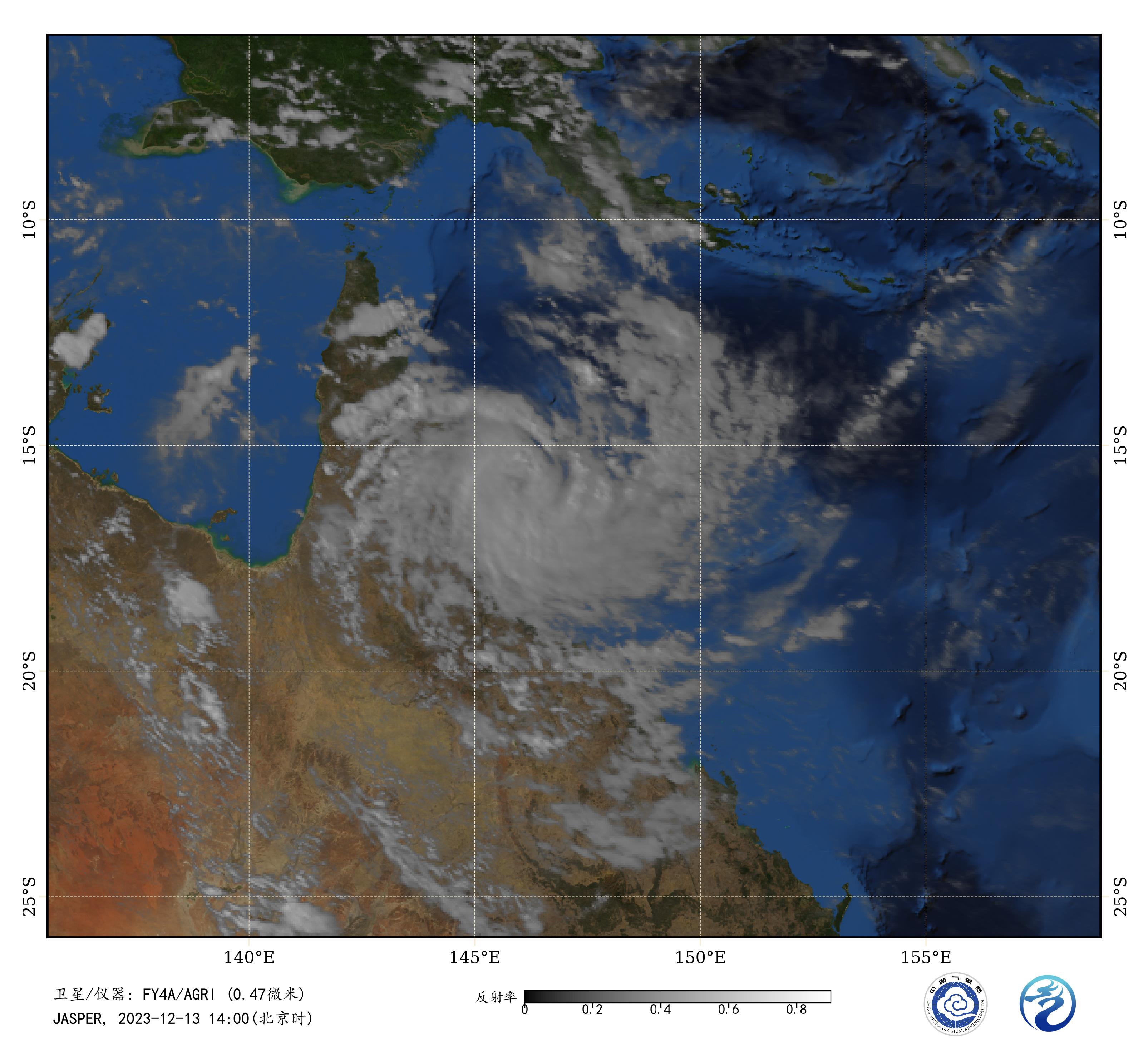
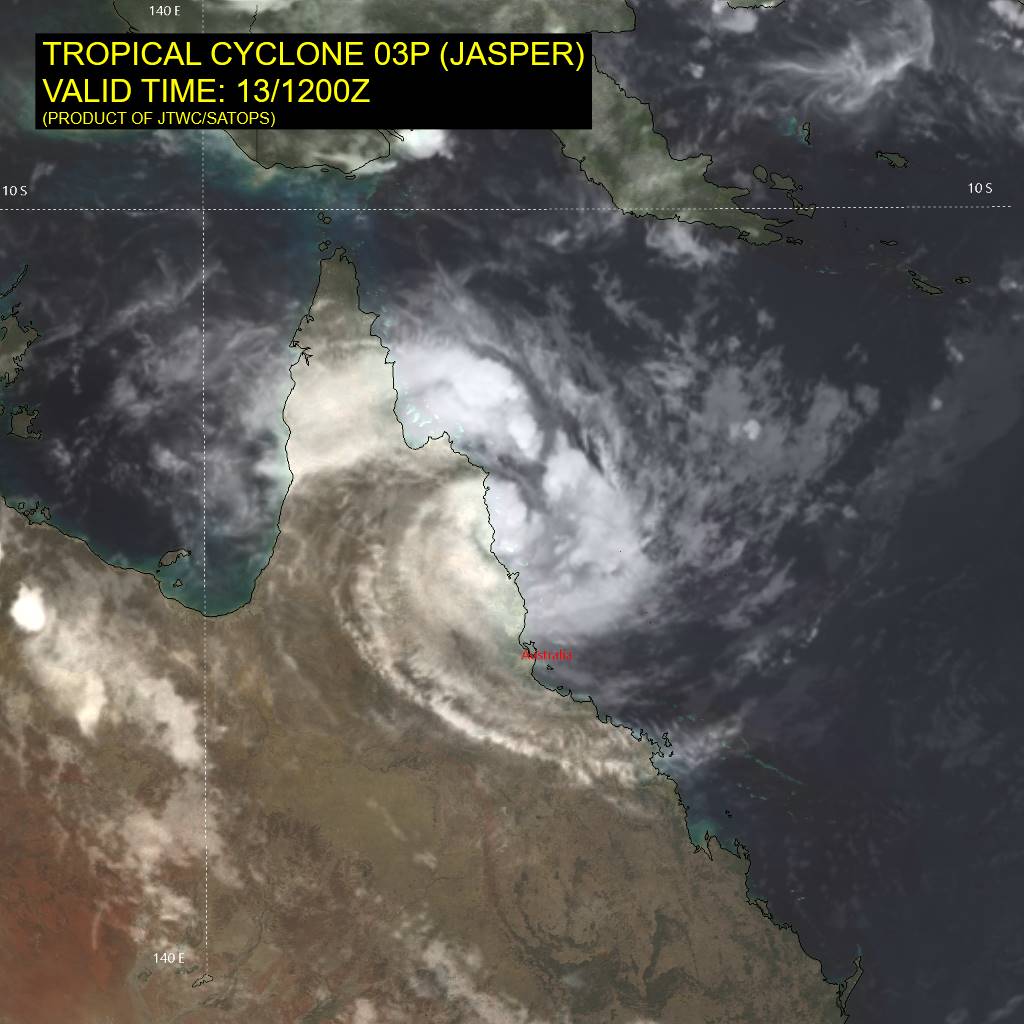
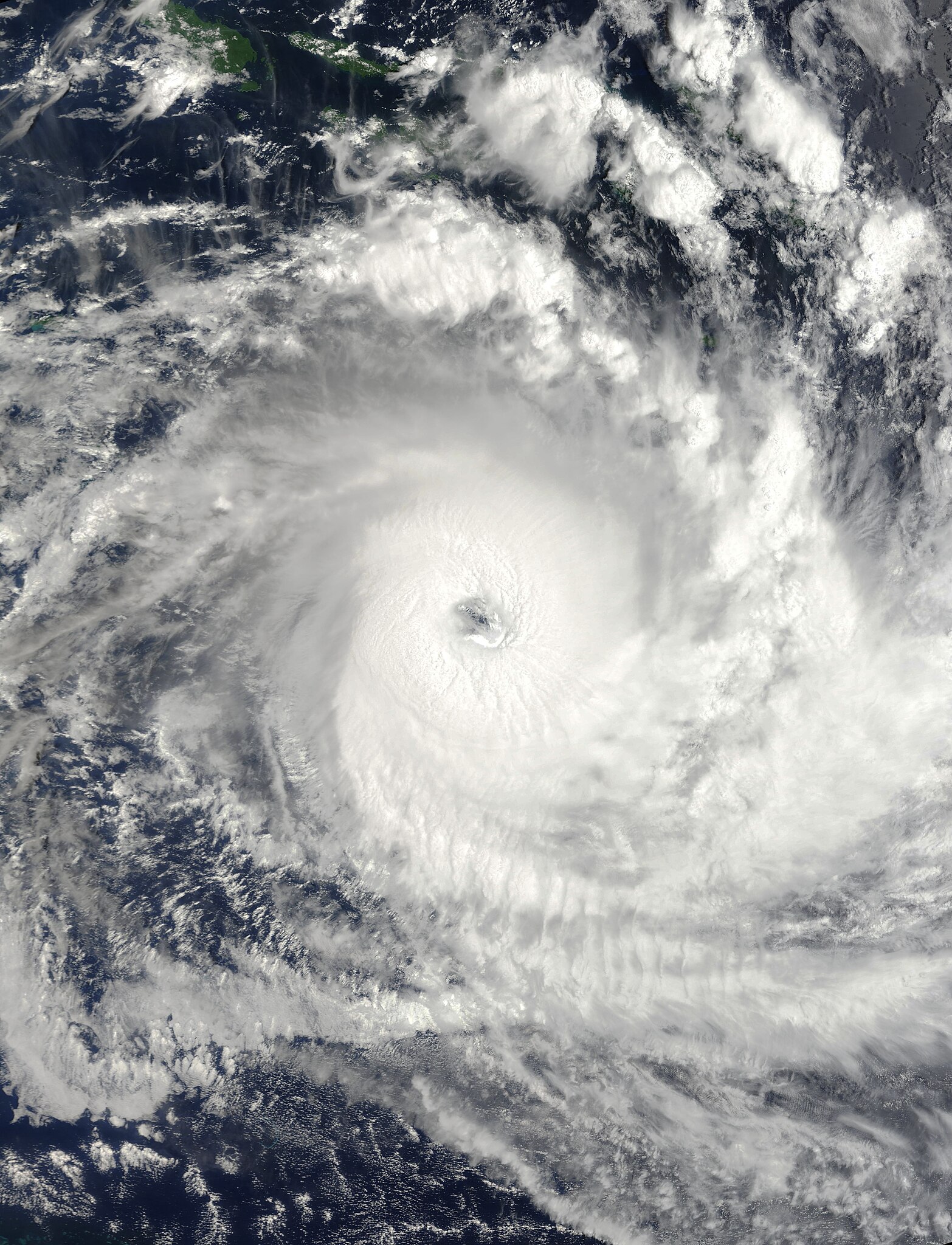
Tropical Cyclone Jasper, Category 2, is producing damaging to destructive wind gusts on the Far North Queensland coast and the centre is now over land near Wujal Wujal.
Areas Affected:
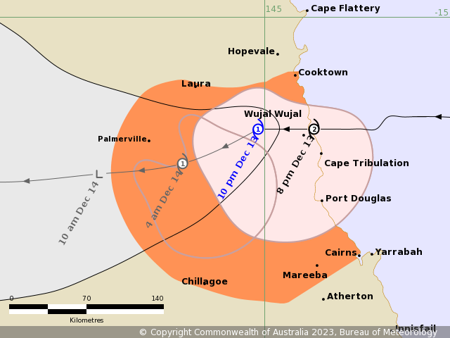
Warning Zone
Cooktown to Cairns, not including Cairns, and extending inland to include the Atherton Tablelands, Chillagoe and Palmerville
Watch Zone
None
Cancelled Zone
Cape Melville to Cooktown and Cairns to Cardwell.
Details of Tropical Cyclone Jasper at 9:00 pm AEST:
Intensity: Category 2, sustained winds near the centre of 95 kilometres per hour with wind gusts to 130 kilometres per hour.
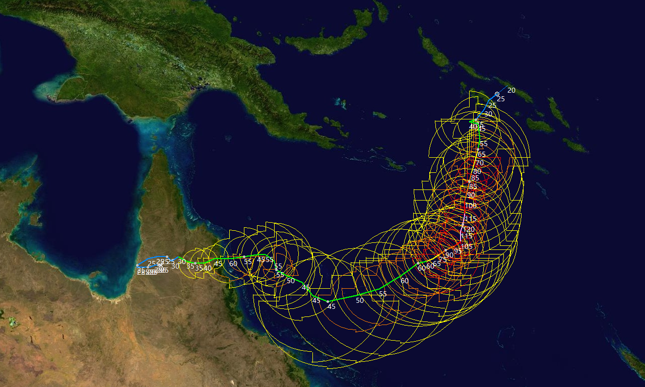
Location: within 20 kilometres of 15.9 degrees South 145.2 degrees East, estimated to be 130 kilometres north northwest of Cairns and 50 kilometres south of Cooktown.
Movement: west at 12 kilometres per hour.
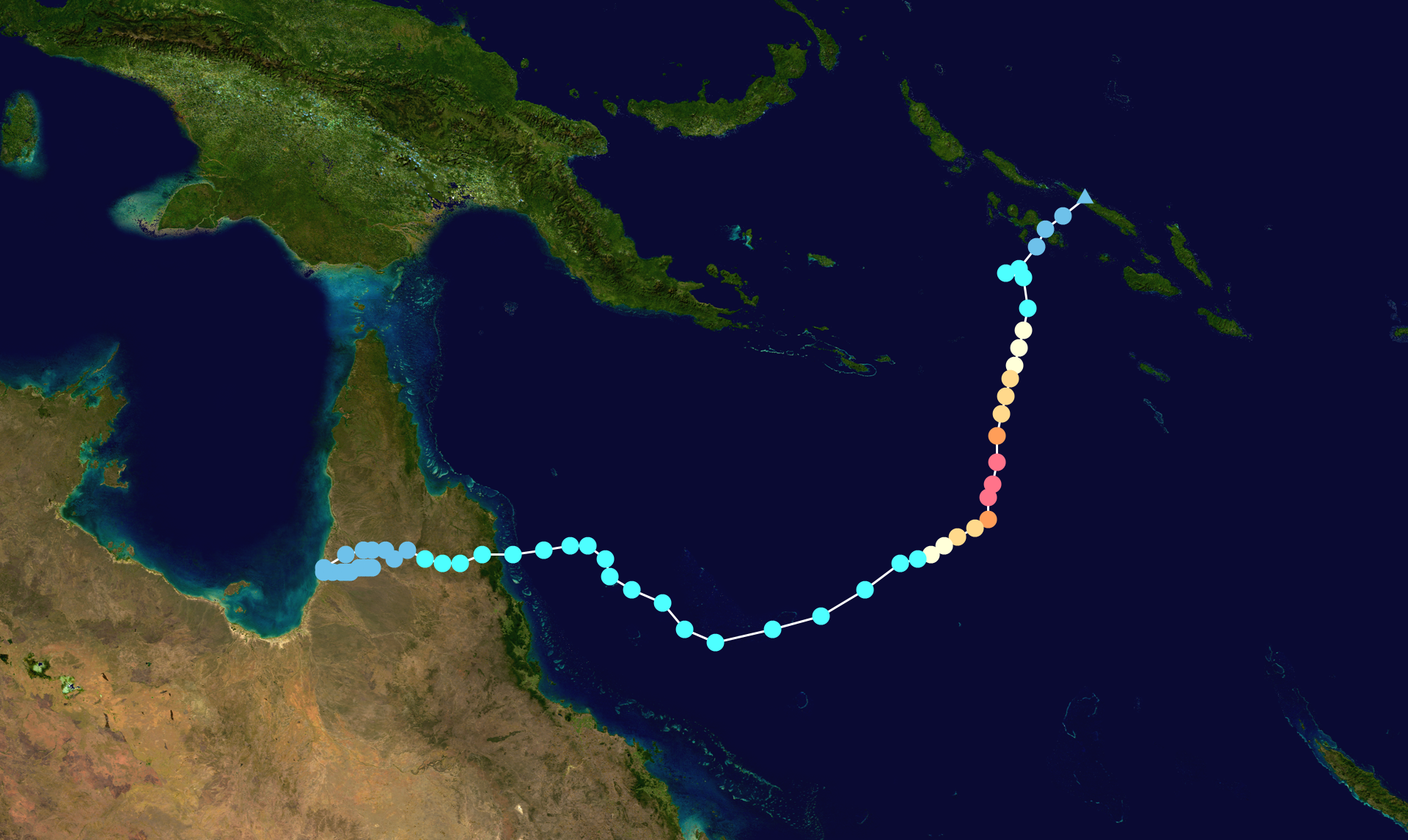
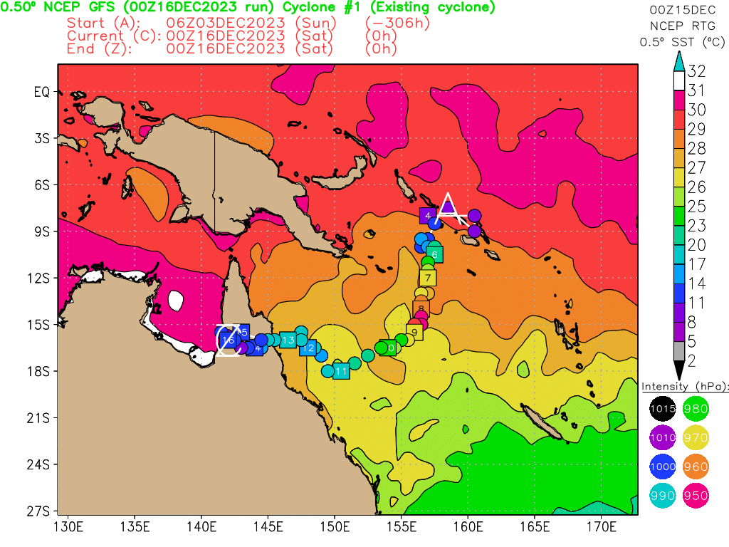
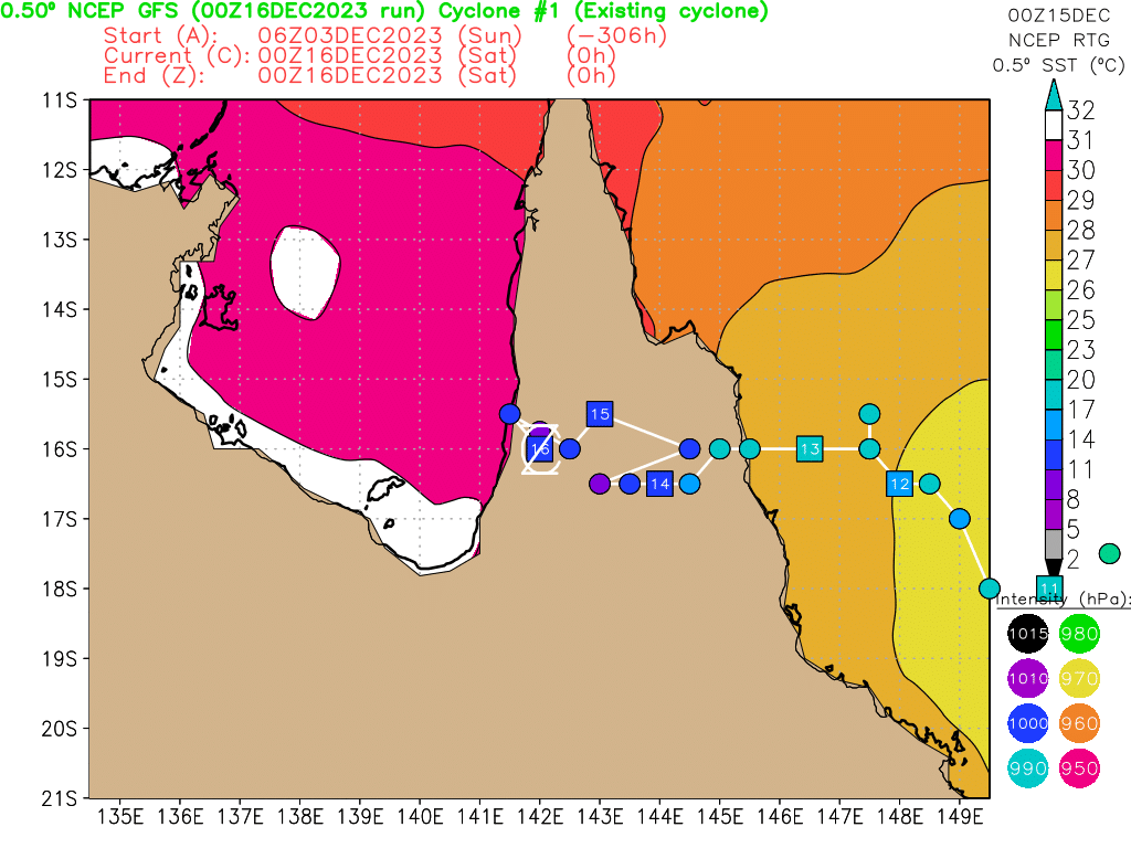
Tropical Cyclone Jasper, a Category 2 system, is producing damaging to destructive wind gusts to the Far North Queensland coast and had now moved over land near Wujal Wujal, just north of Cape Tribulation. Jasper is expected to weaken overnight as it moves inland.
Hazards:
Locally INTENSE RAINFALL which may lead to DANGEROUS AND LIFE-THREATENING FLASH FLOODING is forecast to develop from tonight along the coast and adjacent ranges between Cape Tribulation to Cairns as well as areas near the centre of Tropical Cyclone Jasper. Isolated six-hourly rainfall totals between 250 to 300 mm are likely with 24-hourly totals between 400 to 500 mm possible.
HEAVY RAINFALL which may lead to FLASH FLOODING is also forecast to develop between Cape Flattery and Ingham. Six-hourly rainfall totals between 100 to 150 mm are likely, with isolated falls up to 250 mm along the coast and adjacent ranges. 24-hourly rainfall totals between 150 to 250 mm are likely, with isolated falls up to 350 mm possible.
Please refer to Severe Weather Warning for HEAVY, LOCALLY INTENSE RAINFALL and DAMAGING WINDS for people in parts of Peninsula, Gulf Country and Northern Goldfields and Upper Flinders Forecast Districts.
DESTRUCTIVE wind gusts of up to 140 km/h are expected near and to the south of the track between Wujal Wujal and Port Douglas.
GALES with DAMAGING WIND GUSTS of up to 120 km/h are occurring along the coast between Cooktown and Cairns, but not including Cairns.
DAMAGING WIND GUSTS may extend further inland to the Atherton Tablelands and as far as Palmerville and Chillagoe tonight.
Along the track of the cyclone, the DAMAGING WIND GUSTS may temporarily eased to lighter winds as the eye of the cyclone passes over.
Flood watches and warnings are current for the North Tropical Coast, parts of the Cape York Peninsula and Gulf Country.
A storm tide is expected along the north Queensland coast on the high tide during Thursday morning with total waters generally expected to approach or marginally exceed the Highest Astronomical Tide level. Large waves may produce minor flooding along the foreshore.
Recommended Action:
People between Wujal Wujal and Port Douglas should remain inside until the cyclone has passed and listen to the next advice.
- People in the path of the cyclone should stay calm and remain in a secure shelter while the destructive winds continue.
- Do not venture outside if you find yourself in the eye of the cyclone
- Heed the advice and follow the instructions of Police, Emergency Services personnel and local authorities.
- Boats and outside property should be secured.
People between Cooktown Cairns and inland to Chillagoe and Palmerville should take precautions and listen to the next advice.
- For cyclone preparedness and safety advice, visit Queensland's Disaster Management Services website (www.disaster.qld.gov.au)
- For emergency assistance call the Queensland State Emergency Service (SES) on 132 500 (for assistance with storm damage, rising flood water, fallen trees on buildings or roof damage).
- If you choose to take shelter away from your home, stay COVID-19 safe and pack a mask and hand sanitiser (if you have them).
- For emergency assistance call the Queensland State Emergency Service (SES) on 132 500 (for assistance with storm damage, rising flood water, fallen trees on buildings or roof damage).
Next Advice:
The next advice will be issued by 10:00 pm AEST Wednesday 13 December.
This warning is also available through TV and Radio Broadcasts; the Bureau's website at www.bom.gov.au or call 1300 659 210. The Bureau and the State Emergency Service would appreciate this warning being broadcast regularly.
A map showing the track of the cyclone is available at: http://www.bom.gov.au/cyclone
JTWC11Z分析已登陆
TPPS10 PGTW 131150

A. TROPICAL CYCLONE 03P (JASPER)

B. 13/1130Z

C. 16.20S

D. 145.15E

E. FIVE/HMWRI9

F. N/A

G. IR/EIR

H. REMARKS: 38A/PBO SBC/ANMTN. DVORAK VALUES UNAVAILABLE DUE TO
LLCC OVER LAND.

I. ADDITIONAL POSITIONS:
   13/0643Z  15.93S  145.82E  GPMI
   13/0742Z  15.87S  145.53E  SSMS
   13/0834Z  15.78S  145.48E  SSMS


   PETERSEN
IDQ20018
TROPICAL CYCLONE TECHNICAL BULLETIN: AUSTRALIA - EASTERN REGION
Issued by AUSTRALIAN BUREAU OF METEOROLOGY TROPICAL CYCLONE WARNING CENTRE
at: 1214 UTC 13/12/2023
Name: Tropical Cyclone Jasper
Identifier: 02U
Data At: 1200 UTC
Latitude: 15.9S
Longitude: 144.9E
Location Accuracy: within 10nm (20 km)
Movement Towards: west (266 deg)
Speed of Movement: 7 knots (12 km/h)
Maximum 10-Minute Wind: 40 knots (75 km/h)
Maximum 3-Second Wind Gust: 55 knots (100 km/h)
Central Pressure: 992 hPa
Radius of 34-knot winds NE quadrant: 20 nm (35 km)
Radius of 34-knot winds SE quadrant: 60 nm (110 km)
Radius of 34-knot winds SW quadrant: 35 nm (65 km)
Radius of 34-knot winds NW quadrant: 20 nm (35 km)
Radius of 48-knot winds NE quadrant:
Radius of 48-knot winds SE quadrant:
Radius of 48-knot winds SW quadrant:
Radius of 48-knot winds NW quadrant:
Radius of 64-knot winds: nm ( km)
Radius of Maximum Winds: 20 nm (35 km)
Dvorak Intensity Code: over land
Pressure of outermost isobar: 1002 hPa
Radius of outermost closed isobar: 50 nm (95 km)
FORECAST DATA
Date/Time : Location : Loc. Accuracy: Max Wind : Central Pressure
(UTC) : degrees : nm (km): knots(km/h): hPa
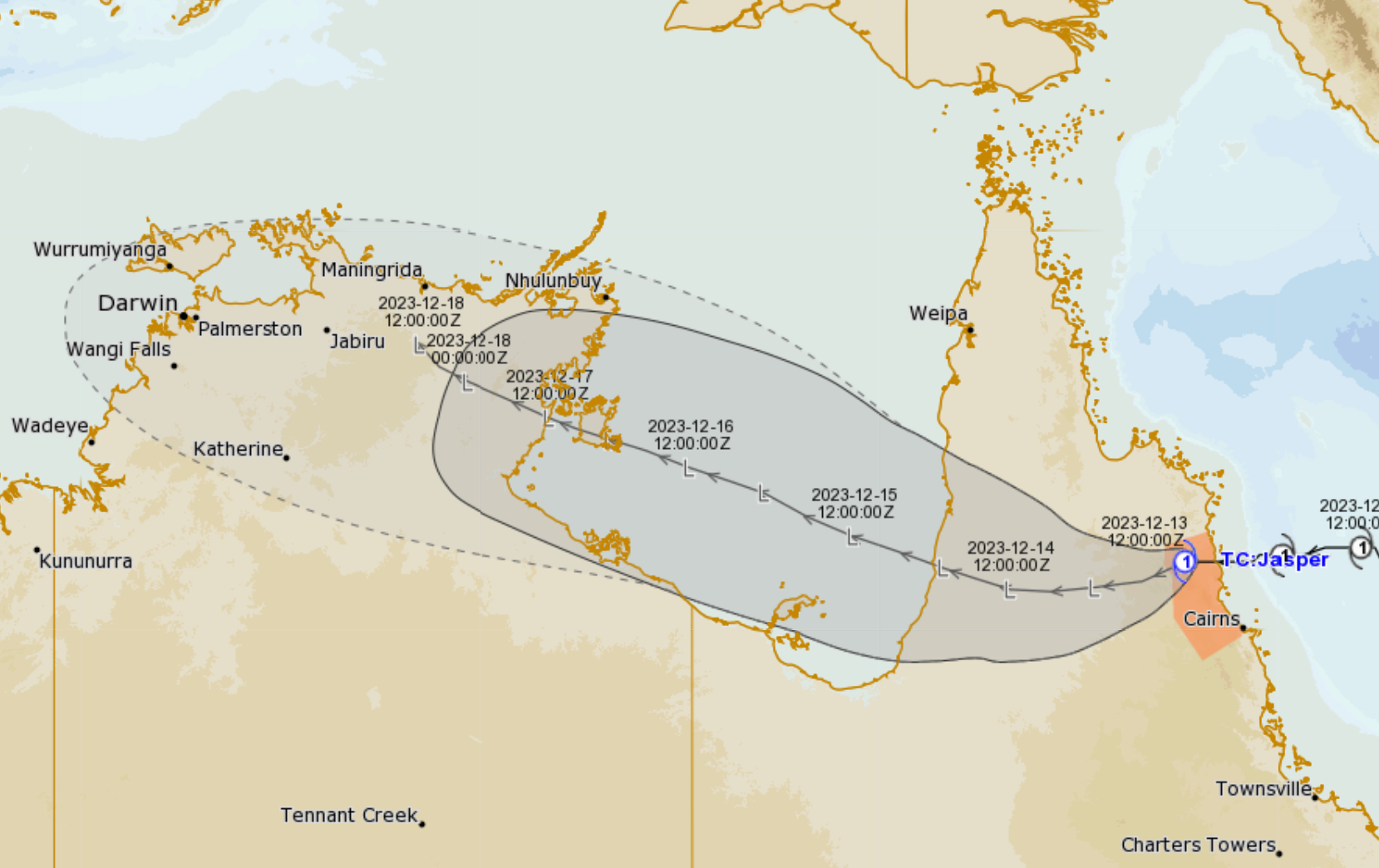
+06: 13/1800: 16.2S 144.3E: 025 (050): 035 (065): 994
+12: 14/0000: 16.3S 143.7E: 045 (080): 030 (055): 997
+18: 14/0600: 16.3S 143.1E: 060 (110): 030 (055): 997
+24: 14/1200: 16.3S 142.5E: 075 (135): 030 (055): 997
+36: 15/0000: 16.0S 141.5E: 100 (185): 025 (045): 999
+48: 15/1200: 15.5S 140.3E: 120 (220): 030 (055): 997
+60: 16/0000: 14.9S 139.0E: 135 (250): 030 (055): 997
+72: 16/1200: 14.6S 138.0E: 150 (280): 030 (055): 997
+96: 17/1200: 13.9S 136.0E: 175 (320): 035 (065): 994
+120: 18/1200: 12.9S 134.1E: 200 (375): 030 (055): 996
REMARKS:
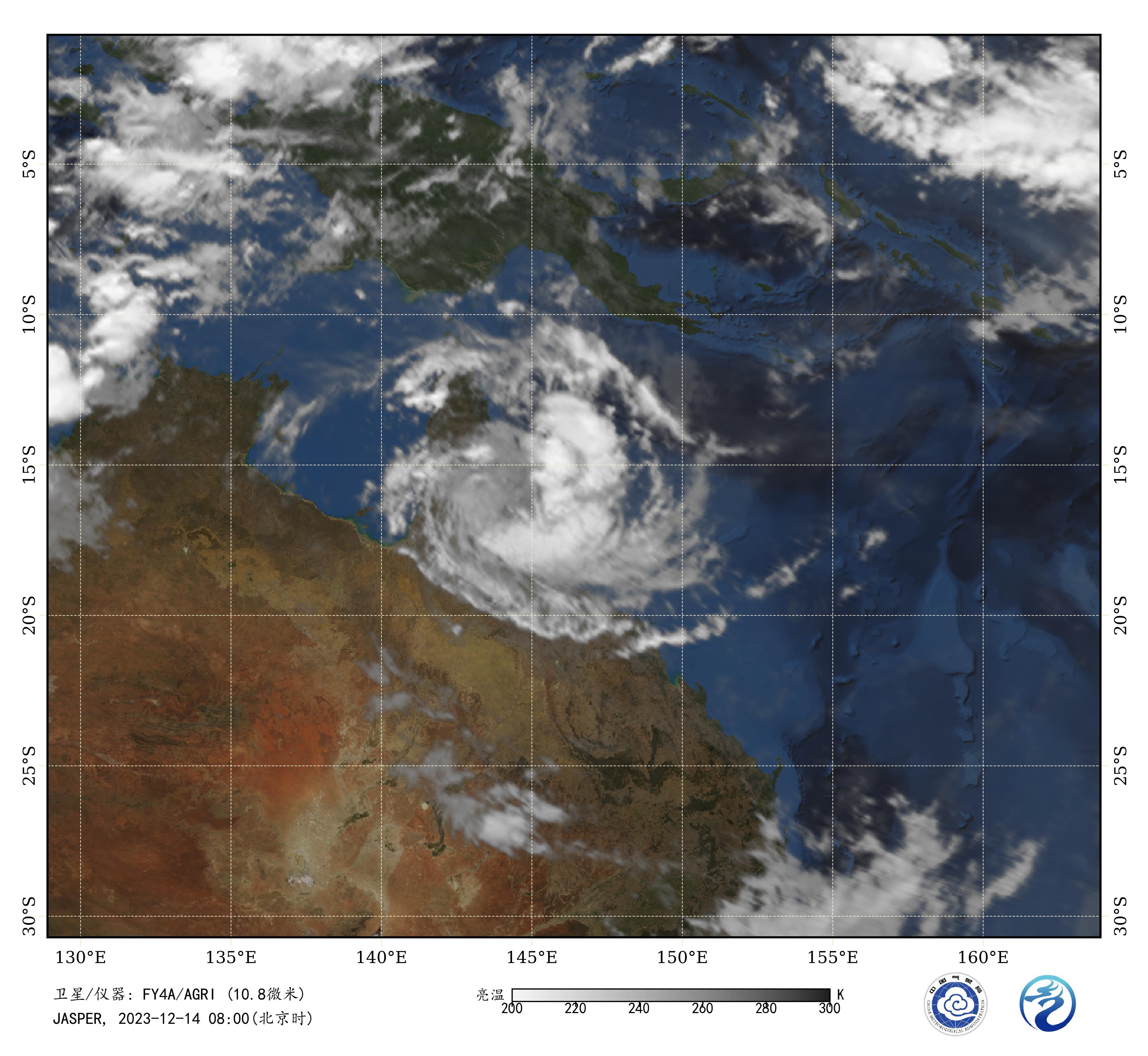
Tropical Cyclone Jasper has made landfall near Wujal Wujal and is weakening
rapidly as it moves inland over elevated terrain.
Position is good based on Cairns radar and local observations.
Dvorak and objective guidance is unavailable since Jasper is located over land.
Intensity is estimated at 40 knots based on recent coastal observations before
landfall. At 1130UTC Low Isles Easterly 34 knots.
In the longer term, model guidance continues Jasper's westerly track across
Cape York Peninsula and into the Gulf of Carpentaria. Redevelopment over the
Gulf of Carpentaria is possible this weekend.
Copyright Commonwealth of Australia
==
The next bulletin for this system will be issued by: 13/1930 UTC.
WTPS31 PGTW 131500
MSGID/GENADMIN/JOINT TYPHOON WRNCEN PEARL HARBOR HI//
SUBJ/TROPICAL CYCLONE 03P (JASPER) WARNING NR 035//
RMKS/
1. TROPICAL CYCLONE 03P (JASPER) WARNING NR 035
   01 ACTIVE TROPICAL CYCLONE IN SOUTHPAC
   MAX SUSTAINED WINDS BASED ON ONE-MINUTE AVERAGE
   WIND RADII VALID OVER OPEN WATER ONLY
    ---
   WARNING POSITION:
   131200Z --- NEAR 15.8S 145.0E
     MOVEMENT PAST SIX HOURS - 260 DEGREES AT 08 KTS
     POSITION ACCURATE TO WITHIN 020 NM
     POSITION BASED ON CENTER LOCATED BY A COMBINATION OF
     SATELLITE, RADAR, SYNOPTIC DATA AND EXTRAPOLATION
   PRESENT WIND DISTRIBUTION:
   MAX SUSTAINED WINDS - 050 KT, GUSTS 065 KT
   WIND RADII VALID OVER OPEN WATER ONLY
   DISSIPATING AS A SIGNIFICANT TROPICAL CYCLONE OVER LAND
   RADIUS OF 050 KT WINDS - 000 NM NORTHEAST QUADRANT
                            020 NM SOUTHEAST QUADRANT
                            025 NM SOUTHWEST QUADRANT
                            000 NM NORTHWEST QUADRANT
   RADIUS OF 034 KT WINDS - 040 NM NORTHEAST QUADRANT
                            030 NM SOUTHEAST QUADRANT
                            045 NM SOUTHWEST QUADRANT
                            035 NM NORTHWEST QUADRANT
   REPEAT POSIT: 15.8S 145.0E
    ---
   FORECASTS:
   12 HRS, VALID AT:
   140000Z --- 16.0S 143.6E
   MAX SUSTAINED WINDS - 040 KT, GUSTS 050 KT
   WIND RADII VALID OVER OPEN WATER ONLY
   DISSIPATING AS A SIGNIFICANT TROPICAL CYCLONE OVER LAND
    ---
   24 HRS, VALID AT:
   141200Z --- 16.0S 142.6E
   MAX SUSTAINED WINDS - 035 KT, GUSTS 045 KT
   WIND RADII VALID OVER OPEN WATER ONLY
   DISSIPATING AS A SIGNIFICANT TROPICAL CYCLONE OVER LAND
   VECTOR TO 36 HR POSIT: 275 DEG/ 04 KTS
    ---
   36 HRS, VALID AT:
   150000Z --- 15.9S 141.8E
   MAX SUSTAINED WINDS - 030 KT, GUSTS 040 KT
   WIND RADII VALID OVER OPEN WATER ONLY
   DISSIPATED AS A SIGNIFICANT TROPICAL CYCLONE OVER LAND
   VECTOR TO 48 HR POSIT: 290 DEG/ 05 KTS
    ---
   EXTENDED OUTLOOK:
   48 HRS, VALID AT:
   151200Z --- 15.5S 140.8E
   MAX SUSTAINED WINDS - 030 KT, GUSTS 040 KT
   WIND RADII VALID OVER OPEN WATER ONLY
   DISSIPATED AS A SIGNIFICANT TROPICAL CYCLONE OVER WATER
   VECTOR TO 72 HR POSIT: 295 DEG/ 05 KTS
    ---
   72 HRS, VALID AT:
   161200Z --- 14.7S 139.1E
   MAX SUSTAINED WINDS - 030 KT, GUSTS 040 KT
   WIND RADII VALID OVER OPEN WATER ONLY
   DISSIPATED AS A SIGNIFICANT TROPICAL CYCLONE OVER WATER
    ---
REMARKS:
131500Z POSITION NEAR 15.8S 144.7E.
13DEC23. TROPICAL CYCLONE 03P (JASPER), LOCATED APPROXIMATELY 80 NM
NORTHWEST OF CAIRNS, AUSTRALIA, HAS TRACKED WESTWARD AT 08 KNOTS OVER
THE PAST SIX HOURS. ANIMATED ENHANCED INFRARED SATELLITE IMAGERY AND A
COMPOSITE RADAR LOOP FROM MOSSMAN, AUSTRALIA, INDICATE THAT TC JASPER
HAS MADE LANDFALL OVER THE EASTERN COAST OF CAPE YORK PENINSULA. IT
WILL CONTINUE TO TRACK WESTWARD AND FURTHER INLAND UNDER THE STEERING
INFLUENCE OF THE STR TO THE SOUTHEAST. ENVIRONMENTAL CONDITIONS WILL
BECOME MORE UNFAVORABLE AS DRY AIR ENTRAINMENT, INTERACTION WITH THE
RUGGED TERRAIN, AND INCREASING VWS WILL RAPIDLY ERODE THE SYSTEM TO
DISSIPATION BY TAU 24, LIKELY SOONER. THE REMNANTS OF TC 03P WILL
CONTINUE WESTWARD INTO THE GULF OF CARPENTARIA AFTER TAU 36. THIS IS
THE FINAL WARNING ON THIS SYSTEM BY THE JOINT TYPHOON WRNCEN PEARL
HARBOR HI. THE SYSTEM WILL BE CLOSELY MONITORED FOR SIGNS OF
REGENERATION. MINIMUM CENTRAL PRESSURE AT 131200Z IS 986 MB.//
NNNN
Media: The Standard Emergency Warning Signal should NOT be used with this warning.
PRIORITY
TROPICAL CYCLONE ADVICE NUMBER 38
Issued at 11:59 pm EST on Wednesday 13 December 2023
Headline:
Ex-tropical cyclone Jasper is no longer of tropical cyclone intensity.
Areas Affected:
Warning Zone
None
Watch Zone
None
Cancelled Zone
Cooktown to Cairns, and extending inland to include the Atherton Tablelands, Chillagoe and Palmerville.
Details of Ex-Tropical Cyclone Jasper at 12:00 am AEST:
Intensity: Tropical Low, sustained winds near the centre of 55 kilometres per hour with wind gusts to 85 kilometres per hour.
Location: within 20 kilometres of 15.8 degrees South 144.7 degrees East, estimated to be 165 kilometres northwest of Cairns and 75 kilometres southwest of Cooktown.
Movement: west at 13 kilometres per hour.
Ex-tropical cyclone Jasper is no longer of tropical cyclone intensity, however, impacts from heavy to intense rainfall and damaging wind gusts with showers and thunderstorms are still likely.
Hazards:
A Severe Weather Warning and Flood watches and warnings are current for Ex-tropical cyclone Jasper
Visit: www.bom.gov.au/qld/warnings/
Recommended Action:
None.
Next Advice:
No further advices will be issued for this system unless it reintensifies.
This warning is also available through TV and Radio Broadcasts; the Bureau's website at www.bom.gov.au or call 1300 659 210. The Bureau and the State Emergency Service would appreciate this warning being broadcast regularly.