ABPW10 PGTW 131500
MSGID/GENADMIN/JOINT TYPHOON WRNCEN PEARL HARBOR HI//
SUBJ/SIGNIFICANT TROPICAL WEATHER ADVISORY FOR THE WESTERN AND SOUTH
PACIFIC OCEANS REISSUED/131500Z-140600ZFEB2024//
RMKS/
1. WESTERN NORTH PACIFIC AREA (180 TO MALAY PENINSULA):
A. TROPICAL CYCLONE SUMMARY: NONE.
B. TROPICAL DISTURBANCE SUMMARY: NONE.
C. SUBTROPICAL SYSTEM SUMMARY: NONE.
2. SOUTH PACIFIC AREA (WEST COAST OF SOUTH AMERICA TO 135 EAST):
A. TROPICAL CYCLONE SUMMARY: NONE.
B. TROPICAL DISTURBANCE SUMMARY:
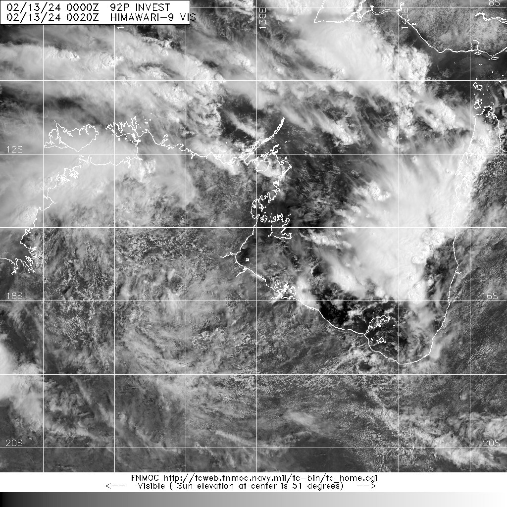
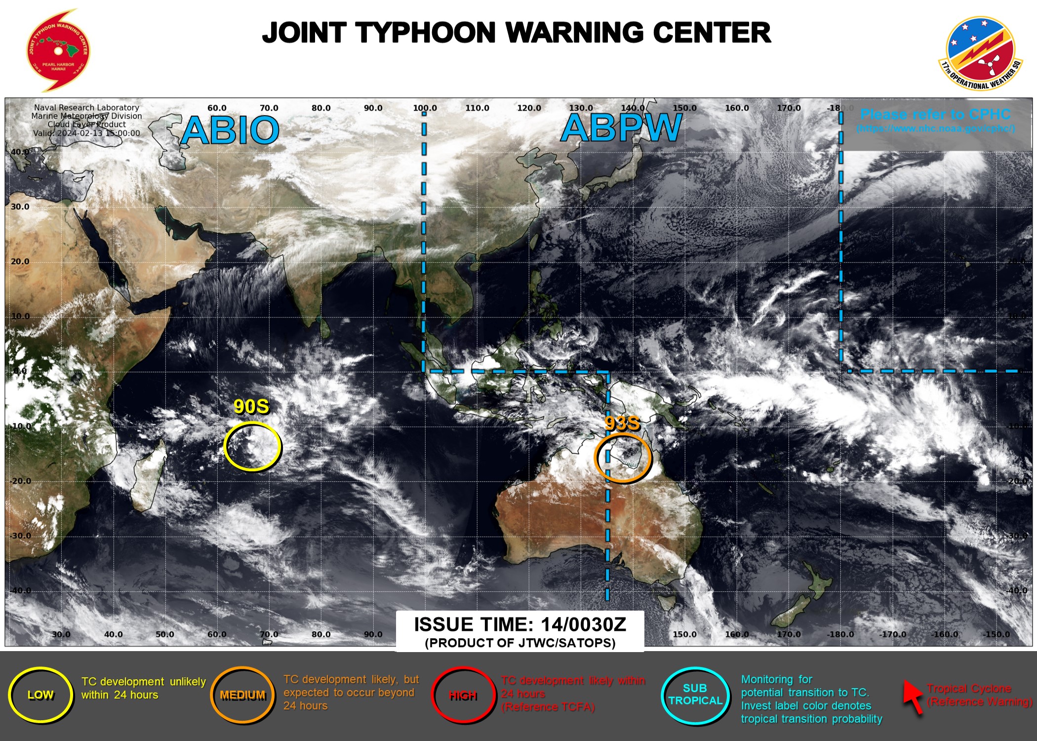
(1) AN AREA OF CONVECTION (INVEST 93S) HAS PERSISTED NEAR 14.1S
135.1E, APPROXIMATELY 230 NM EAST-SOUTHEAST OF DARWIN. ENHANCED
INFRARED IMAGERY AND A 130933Z SSMIS 91GHZ SATELLITE MICROWAVE IMAGE
DEPICTS INTERMITTENT FLARING CONVECTION WITH SHALLOW LOW-LEVEL BANDING
WRAPPING INTO A PARTIALLY EXPOSED, WELL-DEFINED LLCC. ENVIRONMENTAL
ANALYSIS REVEALS A MARGINALLY FAVORABLE ENVIRONMENT FOR CYCLOGENESIS
WITH WARM (29-30 C) SEA SURFACE TEMPERATURES, MODERATE EQUATORWARD
DIVERGENCE ALOFT, OFFSET BY HIGH (20-30 KTS) VERTICAL WIND SHEAR.
GLOBAL MODELS ARE IN GOOD AGREEMENT THAT 93S WILL GENERALLY TRACK
EASTWARD AND FURTHER DEVELOP OVER THE GULF OF CARPENTARIA DURING THE
NEXT 36-48 HOURS. MAXIMUM SUSTAINED SURFACE WINDS ARE ESTIMATED AT 18
TO 23 KNOTS. MINIMUM SEA LEVEL PRESSURE IS ESTIMATED TO BE NEAR 1005
MB. THE POTENTIAL FOR THE DEVELOPMENT OF A SIGNIFICANT TROPICAL CYCLONE
WITHIN THE NEXT 24 HOURS IS LOW.
(2) NO OTHER SUSPECT AREAS.
C. SUBTROPICAL SYSTEM SUMMARY: NONE.
3. JUSTIFICATION FOR REISSUE: ADDED LOW AREA IN PARA. 2.B.(1).//
NNNN
ABPW10 PGTW 140030
MSGID/GENADMIN/JOINT TYPHOON WRNCEN PEARL HARBOR HI//
SUBJ/SIGNIFICANT TROPICAL WEATHER ADVISORY FOR THE WESTERN AND SOUTH
PACIFIC OCEANS REISSUED/140030Z-140600ZFEB2024//
RMKS/
1. WESTERN NORTH PACIFIC AREA (180 TO MALAY PENINSULA):
A. TROPICAL CYCLONE SUMMARY: NONE.
B. TROPICAL DISTURBANCE SUMMARY: NONE.
C. SUBTROPICAL SYSTEM SUMMARY: NONE.
2. SOUTH PACIFIC AREA (WEST COAST OF SOUTH AMERICA TO 135 EAST):
A. TROPICAL CYCLONE SUMMARY: NONE.
B. TROPICAL DISTURBANCE SUMMARY:
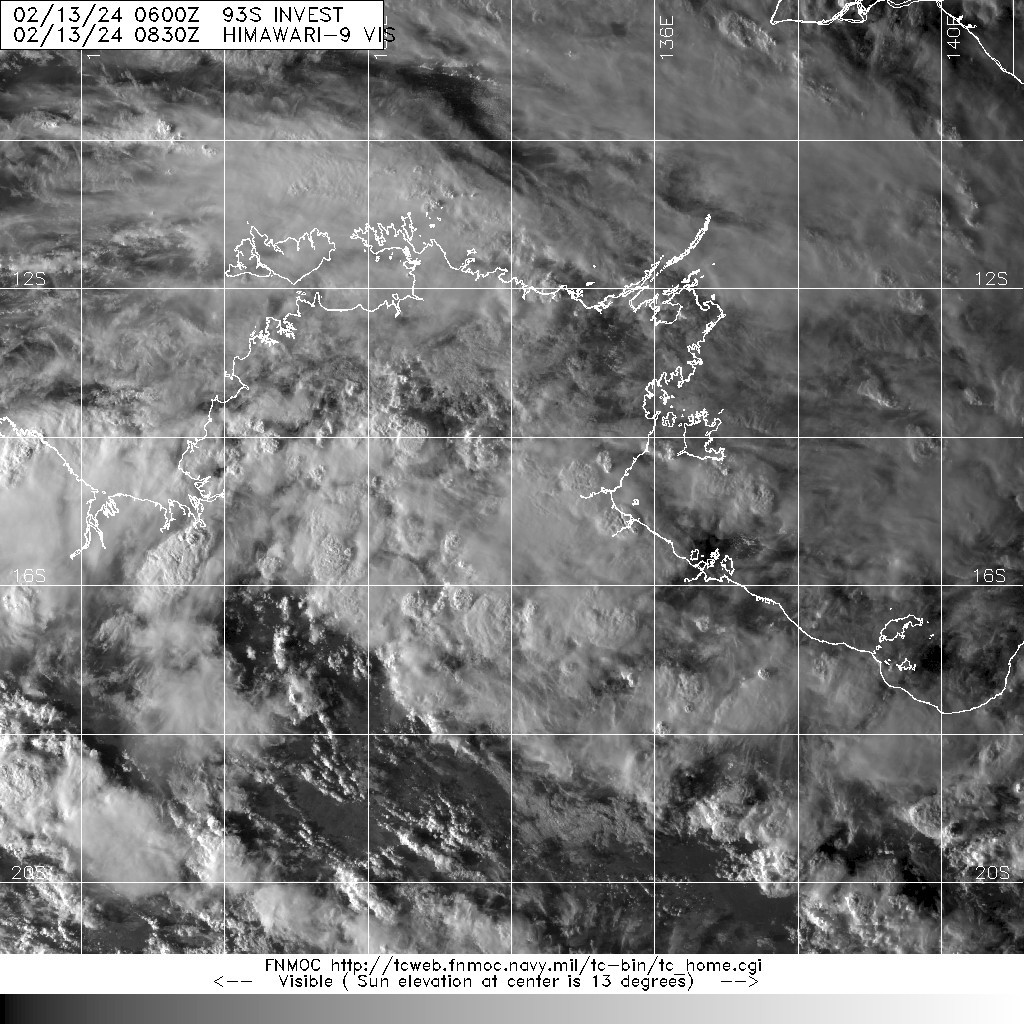
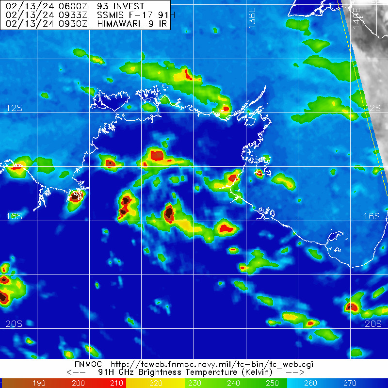
(1) THE AREA OF CONVECTION (INVEST 93S) PREVIOUSLY LOCATED NEAR
14.1S 135.1E IS NOW LOCATED NEAR 15.5S 136.9E, APPROXIMATELY 145 NM
WEST-NORTHWEST OF MORNINGTON ISLAND, AUSTRALIA. ANIMATED MULTISPECTRAL
SATELLITE IMAGERY (MSI) DEPICTS AN ELONGATED LOW LEVEL CIRCULATION (LLC)
WITH PERSISTENT DEEP FLARING CONVECTION. ENVIRONMENTAL ANALYSIS REVEALS
A FAVORABLE ENVIRONMENT FOR CYCLOGENESIS WITH WARM (29-30 C) SEA SURFACE
TEMPERATURES, MODERATE EQUATORWARD DIVERGENCE ALOFT, AND LOW (5-10 KTS)
VERTICAL WIND SHEAR. GLOBAL MODELS ARE IN GOOD AGREEMENT THAT 93S WILL
GENERALLY TRACK EASTWARD THEN TURN SOUTHWARD OR SOUTHWESTWARD WHILE
GRADUALLY DEVELOPING WITHIN THE GULF OF CARPENTARIA DURING THE NEXT 24-
36 HOURS. MESOSCALE GUIDANCE IS ALSO IN GOOD AGREEMENT THAT INVEST 93S
WILL INTENSIFY NEAR WARNING CRITERIA OVER THE NEXT 36-48 HOURS PRIOR TO
POTENTIALLY MOVING BACK INLAND. MAXIMUM SUSTAINED SURFACE WINDS ARE
ESTIMATED AT 23 TO 28 KNOTS. MINIMUM SEA LEVEL PRESSURE IS ESTIMATED TO
BE NEAR 1003 MB. THE POTENTIAL FOR THE DEVELOPMENT OF A SIGNIFICANT
TROPICAL CYCLONE WITHIN THE NEXT 24 HOURS IS UPGRADED TO MEDIUM.
(2) NO OTHER SUSPECT AREAS.
C. SUBTROPICAL SYSTEM SUMMARY: NONE.
3. JUSTIFICATION FOR REISSUE: UPGRADED AREA IN PARA 2.B.(1) TO MEDIUM.//
NNNN
IDD20150
Australian Bureau of Meteorology
Tropical Cyclone Warning Centre
Media: The Standard Emergency Warning Signal should NOT be used with this warning.
PRIORITY
TROPICAL CYCLONE ADVICE NUMBER 1
Issued at 4:29 pm ACST [4:59 pm AEST] on Wednesday 14 February 2024
Headline:
Tropical Low 07U likely to bring strong winds and heavy rainfall to the southern Gulf of Carpentaria coast later Thursday and Friday.
Areas Affected:
Warning Zone
None.
Watch Zone
Port Roper (NT) to Burketown (Qld), including Mornington Island and Borroloola, but not including Ngukurr.
Cancelled Zone
None.
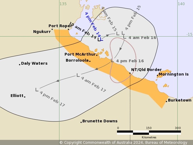
Details of Tropical Low at 3:30 pm ACST [4:00 pm AEST]:
Intensity: Tropical Low, sustained winds near the centre of 35 kilometres per hour with wind gusts to 85 kilometres per hour.
Location: within 75 kilometres of 15.1 degrees South 136.8 degrees East, estimated to be 120 kilometres north northeast of Borroloola and 305 kilometres northwest of Mornington Is.
Movement: slow moving.
Tropical Low 07U is moving slowly in the Gulf of Carpentaria. There is a moderate chance it strengthens into a tropical cyclone overnight Thursday or during Friday. On Friday it is expected to move southwest taking it over the southern Gulf of Carpentaria coast and then weaken overland. On the weekend it will be moving west over the Northern Territory.
Hazards:
GALES with DAMAGING GUSTS to 100 kilometres per hour could develop along the coast between Port McArthur and Mornington Island early Friday morning. Damaging gusts could extend west to Port Roper in the Northern Territory and east to Burketown in Queensland during Friday depending on the movement of 07U.
Periods of heavy rainfall could develop along the southern Gulf of Carpentaria coast during Thursday, becoming more likely on Friday as 07U moves closer to the coast.
Recommended Action:
For people in the Northern Territory NTES advises:
- People in Borroloola and surrounding areas should consider what action they will take should the cyclone threat increase.
- Check your household plan.
- Listen for the next advice.
For cyclone safety and preparation advice www.securent.nt.gov.au
Ensure family, friends and neighbours have received and understood this message.
For people in Queensland between the QLD/NT border and Burketown should consider what action they will need to take if the cyclone threat increases.
- Information is available from your local government
- For cyclone preparedness and safety advice, visit Queensland's Disaster Management Services website (www.disaster.qld.gov.au)
- For emergency assistance call the Queensland State Emergency Service (SES) on 132 500 (for assistance with storm damage, rising flood water, fallen trees on buildings or roof damage).
Next Advice:
The next advice will be issued by 10:30 pm ACST Wednesday 14 February [11:00 pm AEST Wednesday 14 February].
This advice is available on telephone at 1300 659 210
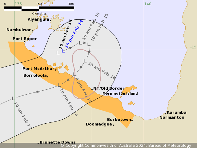
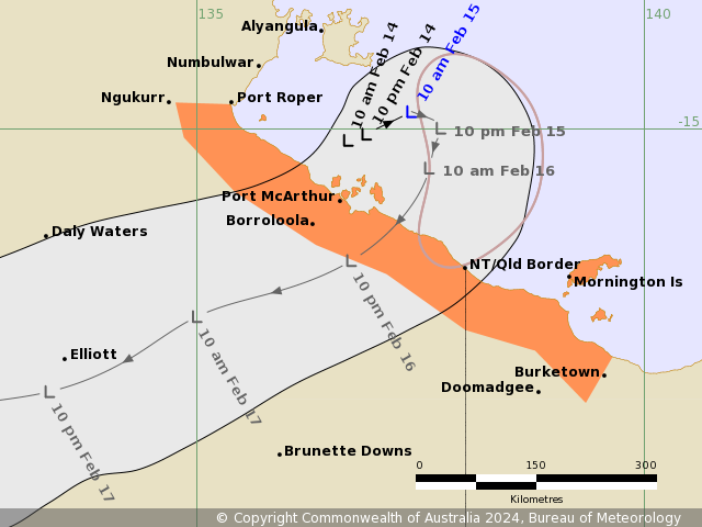
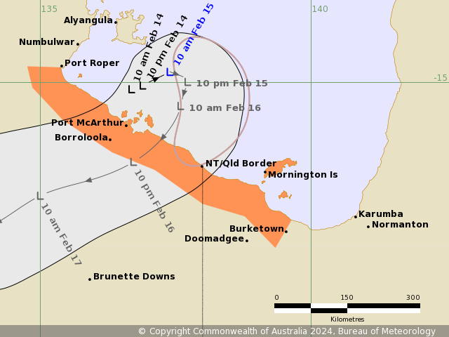
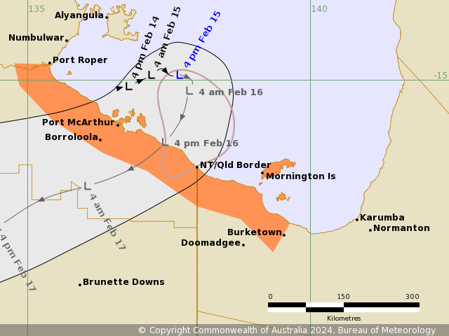
A map showing the track of the cyclone is available at: http://www.bom.gov.au/cyclone
IDD20150

Australian Bureau of Meteorology
Tropical Cyclone Warning Centre

Media: The Standard Emergency Warning Signal should NOT be used with this warning.

PRIORITY
TROPICAL CYCLONE ADVICE NUMBER 2
Issued at 10:12 pm ACST [10:42 pm AEST] on Wednesday 14 February 2024

Headline:
Tropical Low 07U likely to bring strong winds and heavy rainfall to the southern Gulf of Carpentaria later Thursday and Friday.

Areas Affected:
Warning Zone
None.

Watch Zone
Port Roper (NT) to Burketown (Qld), including Mornington Island and Borroloola, but not including Ngukurr.

Cancelled Zone
None.

Details of Tropical Low at 9:30 pm ACST [10:00 pm AEST]:
Intensity: Tropical Low, sustained winds near the centre of 35 kilometres per hour with wind gusts to 85 kilometres per hour.

Location: within 65 kilometres of 15.1 degrees South 136.9 degrees East, estimated to be 130 kilometres north northeast of Borroloola and 300 kilometres northwest of Mornington Is.

Movement: slow moving.

Tropical Low 07U is moving slowly in the Gulf of Carpentaria. There is a moderate chance it strengthens into a tropical cyclone overnight Thursday or during Friday. On Friday it is expected to move southwest taking it over the southern Gulf of Carpentaria coast and then weaken overland. On the weekend it will be moving west over the Northern Territory.

Hazards:
GALES with DAMAGING WIND GUSTS to 100 kilometres per hour could develop along the coast between Port McArthur and Mornington Island early Friday morning. Damaging wind gusts could extend west to Port Roper in the Northern Territory and east to Burketown in Queensland during Friday depending on the movement of 07U.

HEAVY RAINFALL could develop along the southern Gulf of Carpentaria coast during Thursday, becoming more likely on Friday as 07U moves closer to the coast. Locally INTENSE RAINFALL is also possible depending on the development of 07U.

Tides will be HIGHER THAN NORMAL between King Ash Bay and Port Roper. Large waves may produce MINOR FLOODING of low-lying coastal areas.

Recommended Action:
For people in the Northern Territory NTES advises:

- People in Borroloola and surrounding areas should consider what action they will take should the cyclone threat increase.

- Check your household plan.

- Listen for the next advice.

For cyclone safety and preparation advice www.securent.nt.gov.au

Ensure family, friends and neighbours have received and understood this message.

For people in Queensland between the QLD/NT border and Burketown should consider what action they will need to take if the cyclone threat increases.

- Information is available from your local government

- For cyclone preparedness and safety advice, visit Queensland's Disaster Management Services website (www.disaster.qld.gov.au)

- For emergency assistance call the Queensland State Emergency Service (SES) on 132 500 (for assistance with storm damage, rising flood water, fallen trees on buildings or roof damage).

Next Advice:
The next advice will be issued by 4:30 am ACST Thursday 15 February [5:00 am AEST Thursday 15 February].

This advice is available on telephone at 1300 659 210

A map showing the track of the cyclone is available at: http://www.bom.gov.au/cyclone
IDD20150
Australian Bureau of Meteorology
Tropical Cyclone Warning Centre
Media: The Standard Emergency Warning Signal should NOT be used with this warning.
PRIORITY
TROPICAL CYCLONE ADVICE NUMBER 3
Issued at 4:15 am ACST [4:45 am AEST] on Thursday 15 February 2024
Headline:
Tropical Low 07U likely to bring strong winds and heavy rainfall to the southern Gulf of Carpentaria later Thursday and during Friday.
Areas Affected:
Warning Zone
None.
Watch Zone
Port Roper (NT) to Burketown (Qld), including Mornington Island and Borroloola, but not including Ngukurr.
Cancelled Zone
None.
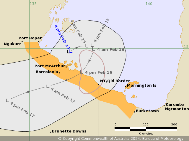
Details of Tropical Low at 3:30 am ACST [4:00 am AEST]:
Intensity: Tropical Low, sustained winds near the centre of 45 kilometres per hour with wind gusts to 85 kilometres per hour.
Location: within 55 kilometres of 14.9 degrees South 137.2 degrees East, estimated to be 160 kilometres northeast of Borroloola and 295 kilometres northwest of Mornington Island.
Movement: slow moving.
Tropical Low 07U is moving slowly in the Gulf of Carpentaria. There is a moderate chance it strengthens into a tropical cyclone overnight Thursday or during Friday. On Friday it is expected to move southwest taking it over the southern Gulf of Carpentaria coast and then weaken overland. On the weekend it will be moving west over the Northern Territory.
Hazards:
GALES with DAMAGING WIND GUSTS to 100 kilometres per hour could develop along the coast between Port McArthur and Mornington Island on Friday morning. Damaging wind gusts could extend west to Port Roper in the Northern Territory and east to Burketown in Queensland during Friday depending on the movement of 07U.
HEAVY RAINFALL could develop along the southern Gulf of Carpentaria coast during Thursday, becoming more likely on Friday as 07U moves closer to the coast. Locally INTENSE RAINFALL is also possible depending on the development of 07U.
Tides will be HIGHER THAN NORMAL between King Ash Bay and Port Roper. Large waves may produce MINOR FLOODING of low-lying coastal areas.
Recommended Action:
For people in the Northern Territory NTES advises:
- People in Borroloola and surrounding areas should consider what action they will take should the cyclone threat increase.
- Check your household plan.
- Listen for the next advice.
For cyclone safety and preparation advice www.securent.nt.gov.au
Ensure family, friends and neighbours have received and understood this message.
For people in Queensland between the QLD/NT border and Burketown should consider what action they will need to take if the cyclone threat increases.
- Information is available from your local government
- For cyclone preparedness and safety advice, visit Queensland's Disaster Management Services website (www.disaster.qld.gov.au)
- For emergency assistance call the Queensland State Emergency Service (SES) on 132 500 (for assistance with storm damage, rising flood water, fallen trees on buildings or roof damage).
Next Advice:
The next advice will be issued by 10:30 am ACST Thursday 15 February [11:00 am AEST Thursday 15 February].
This advice is available on telephone at 1300 659 210
A map showing the track of the cyclone is available at: http://www.bom.gov.au/cyclone
IDD20150
Australian Bureau of Meteorology
Tropical Cyclone Warning Centre
Media: The Standard Emergency Warning Signal should NOT be used with this warning.
TOP PRIORITY FOR IMMEDIATE BROADCAST
TROPICAL CYCLONE ADVICE NUMBER 4
Issued at 10:27 am ACST [10:57 am AEST] on Thursday 15 February 2024
Headline:
Tropical Low 07U likely to bring strong winds and heavy rainfall to the southern Gulf of Carpentaria coast tonight and during Friday.
Areas Affected:
Warning Zone
Port Roper (NT) to Burketown (Qld), including Mornington Island and Borroloola, but not including Ngukurr.
Watch Zone
None.
Cancelled Zone
None.
Details of Tropical Low at 9:30 am ACST [10:00 am AEST]:
Intensity: Tropical Low, sustained winds near the centre of 55 kilometres per hour with wind gusts to 85 kilometres per hour.
Location: within 55 kilometres of 14.8 degrees South 137.4 degrees East, estimated to be 185 kilometres northeast of Borroloola and 280 kilometres northwest of Mornington Island.
Movement: slow moving.
Tropical Low 07U remains slow moving in the Gulf of Carpentaria and is expected to move to the southwest on Friday across the southern Gulf of Carpentaria coast. There is a moderate chance it strengthens into a tropical cyclone overnight Thursday or during Friday. Later Friday it will weaken inland and then move west across the Northern Territory.
Hazards:
GALES with DAMAGING WIND GUSTS to 100 kilometres per hour could develop along the coast between Port McArthur and Mornington Island on Friday morning. Damaging wind gusts could extend west to Port Roper in the Northern Territory and east to Burketown in Queensland during Friday depending on the movement of 07U.
HEAVY RAINFALL could develop along the southern Gulf of Carpentaria coast during Thursday, becoming more likely on Friday as 07U moves closer to the coast. Locally intense rainfall is also possible depending on the development of 07U.
Tides will be HIGHER THAN NORMAL across southern Gulf of Carpentaria on Friday and extending to western Gulf of Carpentaria Saturday. Large waves may produce MINOR FLOODING of low-lying coastal areas as the system nears the coast on Friday.
Recommended Action:
For people in the Northern Territory NTES advises:
- People in Borroloola and surrounding areas should consider what action they will take should the cyclone threat increase.
- Check your household plan.
- Listen for the next advice.
For cyclone safety and preparation advice www.securent.nt.gov.au
Ensure family, friends and neighbours have received and understood this message.
For people in Queensland between the QLD/NT border and Burketown should consider what action they will need to take if the cyclone threat increases.
- Information is available from your local government
- For cyclone preparedness and safety advice, visit Queensland's Disaster Management Services website (www.disaster.qld.gov.au)
- For emergency assistance call the Queensland State Emergency Service (SES) on 132 500 (for assistance with storm damage, rising flood water, fallen trees on buildings or roof damage).
Next Advice:
The next advice will be issued by 1:30 pm ACST Thursday 15 February [2:00 pm AEST Thursday 15 February].
This advice is available on telephone at 1300 659 210
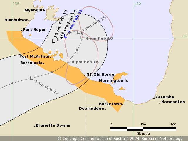
A map showing the track of the cyclone is available at: http://www.bom.gov.au/cyclone
IDD20150
Australian Bureau of Meteorology
Tropical Cyclone Warning Centre
Media: The Standard Emergency Warning Signal should NOT be used with this warning.
TOP PRIORITY FOR IMMEDIATE BROADCAST
TROPICAL CYCLONE ADVICE NUMBER 6
Issued at 4:20 pm ACST [4:50 pm AEST] on Thursday 15 February 2024
Headline:
Tropical Low 07U likely to bring strong winds and heavy rainfall to the southern Gulf of Carpentaria coast ahead of expected coastal crossing on Friday.
Areas Affected:
Warning Zone
Port Roper (NT) to Burketown (Qld), including Mornington Island and Borroloola, but not including Ngukurr.
Watch Zone
None.
Cancelled Zone
None.
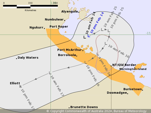
Details of Tropical Low at 3:30 pm ACST [4:00 pm AEST]:
Intensity: Tropical Low, sustained winds near the centre of 55 kilometres per hour with wind gusts to 85 kilometres per hour.
Location: within 35 kilometres of 14.9 degrees South 137.7 degrees East, estimated to be 200 kilometres northeast of Borroloola and 255 kilometres northwest of Mornington Island.
Movement: east southeast at 6 kilometres per hour.
Tropical Low 07U remains slow moving in the Gulf of Carpentaria and is expected to move to the southwest on Friday to make landfall between the NT/Qld border and Port Roper (NT). There is a moderate chance it strengthens into a tropical cyclone on Friday ahead of coastal crossing. Even if it doesn't develop into a tropical cyclone, parts of the Gulf of Carpentaria coast are likely to experience strong to gale force winds and heavy rainfall.
Later Friday it will weaken inland and then move west across the Northern Territory.
Hazards:
GALES with DAMAGING WIND GUSTS to 100 kilometres per hour could develop along the coast between Port McArthur and Mornington Island on Friday morning. There is a small chance that damaging wind gusts could extend west to Port Roper in the Northern Territory or east to Burketown in Queensland during Friday depending on the movement of 07U.
HEAVY RAINFALL is expected to develop along the southern Gulf of Carpentaria coast today, becoming more likely on Friday as 07U moves closer to the coast. Locally intense rainfall is also possible depending on the development of 07U.
Tides will be HIGHER THAN NORMAL across southern Gulf of Carpentaria on Friday and extending to western Gulf of Carpentaria Saturday. Large waves may produce MINOR FLOODING of low-lying coastal areas as the system nears the coast on Friday.
Recommended Action:
For people in the Northern Territory NTES advises:
- People in Borroloola and surrounding areas should activate their household plan now.
- Start preparations for a cyclone, know where you will shelter.
- Listen for the next advice.
For cyclone safety and preparation advice www.securent.nt.gov.au
Ensure family, friends and neighbours have received and understood this message.
For people in Queensland between the QLD/NT border and Burketown should consider what action they will need to take if the cyclone threat increases.
- Information is available from your local government
- For cyclone preparedness and safety advice, visit Queensland's Disaster Management Services website (www.disaster.qld.gov.au)
- For emergency assistance call the Queensland State Emergency Service (SES) on 132 500 (for assistance with storm damage, rising flood water, fallen trees on buildings or roof damage).
Next Advice:
The next advice will be issued by 7:30 pm ACST Thursday 15 February [8:00 pm AEST Thursday 15 February].
This advice is available on telephone at 1300 659 210
A map showing the track of the cyclone is available at: http://www.bom.gov.au/cyclone