-

IDD20150
Australian Bureau of Meteorology
Tropical Cyclone Warning CentreMedia: The Standard Emergency Warning Signal should NOT be used with this warning.
TOP PRIORITY FOR IMMEDIATE BROADCAST
TROPICAL CYCLONE ADVICE NUMBER 7
Issued at 7:30 pm ACST [8:00 pm AEST] on Thursday 15 February 2024Headline:
Tropical Low 07U likely to bring strong winds and heavy rainfall to the southern Gulf of Carpentaria coast ahead of expected coastal crossing on Friday.Areas Affected:
Warning Zone
Port Roper (NT) to Burketown (Qld), including Mornington Island and Borroloola, but not including Ngukurr.Watch Zone
None.Cancelled Zone
None.Details of Tropical Low at 6:30 pm ACST [7:00 pm AEST]:
Intensity: Tropical Low, sustained winds near the centre of 55 kilometres per hour with wind gusts to 85 kilometres per hour.Location: within 35 kilometres of 15.2 degrees South 137.9 degrees East, estimated to be 195 kilometres east northeast of Borroloola and 215 kilometres northwest of Mornington Island.
Movement: southeast at 7 kilometres per hour.
Tropical Low 07U remains slow moving in the Gulf of Carpentaria and is expected to move to the southwest on Friday to make landfall between the NT/Qld border and Port Roper (NT). There is a moderate chance it strengthens into a tropical cyclone on Friday ahead of coastal crossing. Even if it doesn't develop into a tropical cyclone, parts of the Gulf of Carpentaria coast are likely to experience strong to gale force winds and heavy rainfall.
Later Friday it will weaken inland and then move west across the Northern Territory.
Hazards:
GALES with DAMAGING WIND GUSTS to 100 kilometres per hour could develop along the coast between Port McArthur and Mornington Island on Friday morning. There is a small chance that damaging wind gusts could extend west to Port Roper in the Northern Territory or east to Burketown in Queensland during Friday depending on the movement of 07U.HEAVY RAINFALL is expected to develop along the southern Gulf of Carpentaria coast overnight Thursday, becoming more likely on Friday as 07U moves closer to the coast. Locally intense rainfall is also possible depending on the development of 07U.
Tides will be HIGHER THAN NORMAL across southern Gulf of Carpentaria on Friday and extending to western Gulf of Carpentaria Saturday. Large waves may produce MINOR FLOODING of low-lying coastal areas as the system nears the coast on Friday.
Recommended Action:
For people in the Northern Territory NTES advises:- People in Borroloola and surrounding areas should activate their household plan now.
- Start preparations for a cyclone, know where you will shelter.
- Listen for the next advice.
For cyclone safety and preparation advice www.securent.nt.gov.au
Ensure family, friends and neighbours have received and understood this message.
For people in Queensland between the QLD/NT border and Burketown should consider what action they will need to take if the cyclone threat increases.
- Information is available from your local government
- For cyclone preparedness and safety advice, visit Queensland's Disaster Management Services website (www.disaster.qld.gov.au)
- For emergency assistance call the Queensland State Emergency Service (SES) on 132 500 (for assistance with storm damage, rising flood water, fallen trees on buildings or roof damage).
Next Advice:
The next advice will be issued by 10:30 pm ACST Thursday 15 February [11:00 pm AEST Thursday 15 February].This advice is available on telephone at 1300 659 210
A map showing the track of the cyclone is available at: http://www.bom.gov.au/cyclone
Time (ACST) Intensity Category Latitude
(decimal deg.)Longitude
(decimal deg.)Estimated Position
Accuracy (km)0hr 7 pm February 15 tropical low 15.2S 137.9E 35 +6hr 1 am February 16 tropical low 15.3S 138.0E 65 +12hr 7 am February 16 tropical low 15.6S 137.9E 85 +18hr 1 pm February 16 tropical low 16.0S 137.7E 95 +24hr 7 pm February 16 tropical low 16.5S 137.3E 95 +36hr 7 am February 17 tropical low 17.2S 135.7E 90 +48hr 7 pm February 17 tropical low 18.0S 134.1E 110 +60hr 7 am February 18 tropical low 18.5S 132.1E 145 +72hr 7 pm February 18 tropical low 19.0S 130.6E 190 -

IDD20150

Australian Bureau of Meteorology
Tropical Cyclone Warning Centre

Media: The Standard Emergency Warning Signal should NOT be used with this warning.

TOP PRIORITY FOR IMMEDIATE BROADCAST
TROPICAL CYCLONE ADVICE NUMBER 8
Issued at 10:24 pm ACST [10:54 pm AEST] on Thursday 15 February 2024

Headline:
Tropical Low 07U likely to bring strong winds and heavy rainfall to the southern Gulf of Carpentaria coast ahead of expected coastal crossing on Friday.

Areas Affected:
Warning Zone
Port Roper (NT) to Burketown (Qld), including Mornington Island and Borroloola, but not including Ngukurr .

Watch Zone
None.

Cancelled Zone
None.

Details of Tropical Low at 9:30 pm ACST [10:00 pm AEST]:
Intensity: Tropical Low, sustained winds near the centre of 55 kilometres per hour with wind gusts to 85 kilometres per hour.

Location: within 55 kilometres of 15.4 degrees South 138.0 degrees East, estimated to be 195 kilometres east northeast of Borroloola and 190 kilometres northwest of Mornington Island.

Movement: south southeast at 8 kilometres per hour.

Tropical Low 07U is expected to remain slow moving in the Gulf of Carpentaria overnight Thursday before moving southwest on Friday. The system is forecast to make landfall between the NT/Qld border and Port Roper (NT) during Friday, most likely in the afternoon or evening. There is a moderate chance it strengthens into a tropical cyclone on Friday ahead of coastal crossing. Even if it doesn't develop into a tropical cyclone, parts of the Gulf of Carpentaria coast are likely to experience strong to gale force winds and heavy rainfall.

Later Friday it will weaken inland and then move west across the Northern Territory.

Hazards:
GALES with DAMAGING WIND GUSTS to 100 kilometres per hour could develop along the coast between Bing Bong and Mornington Island during Friday morning. There is a small chance that damaging wind gusts could extend west to Port Roper in the Northern Territory or east to Burketown in Queensland during Friday depending on the movement of 07U.

HEAVY RAINFALL is expected to develop along the southern Gulf of Carpentaria coast through the overnight period, becoming more likely on Friday as 07U moves closer to the coast. Locally intense rainfall is also possible depending on the development of 07U.

Tides will be HIGHER THAN NORMAL across southern Gulf of Carpentaria on Friday and extending to western Gulf of Carpentaria Saturday. Large waves may produce MINOR FLOODING of low-lying coastal areas as the system nears the coast on Friday.

Recommended Action:
For people in the Northern Territory NTES advises:

- People in Borroloola and surrounding areas should activate their household plan now.

- Start preparations for a cyclone, know where you will shelter.

- Listen for the next advice.

For cyclone safety and preparation advice www.securent.nt.gov.au

Ensure family, friends and neighbours have received and understood this message.

For people in Queensland between the QLD/NT border and Burketown should consider what action they will need to take if the cyclone threat increases.

- Information is available from your local government

- For cyclone preparedness and safety advice, visit Queensland's Disaster Management Services website (www.disaster.qld.gov.au)

- For emergency assistance call the Queensland State Emergency Service (SES) on 132 500 (for assistance with storm damage, rising flood water, fallen trees on buildings or roof damage).

Next Advice:
The next advice will be issued by 1:30 am ACST Friday 16 February [2:00 am AEST Friday 16 February].

This advice is available on telephone at 1300 659 210

A map showing the track of the cyclone is available at: http://www.bom.gov.au/cyclone
Time (ACST) Intensity Category Latitude
(decimal deg.)Longitude
(decimal deg.)Estimated Position
Accuracy (km)0hr 10 pm February 15 tropical low 15.4S 138.0E 55 +6hr 4 am February 16 tropical low 15.5S 138.0E 75 +12hr 10 am February 16 tropical low 15.8S 138.0E 90 +18hr 4 pm February 16 tropical low 16.3S 137.7E 100 +24hr 10 pm February 16 tropical low 16.6S 137.1E 105 +36hr 10 am February 17 tropical low 17.1S 135.5E 105 +48hr 10 pm February 17 tropical low 17.7S 134.1E 135 +60hr 10 am February 18 tropical low 18.1S 132.0E 165 +72hr 10 pm February 18 tropical low 18.4S 130.7E 210
Time (AEST) Intensity Category Latitude
(decimal deg.)Longitude
(decimal deg.)Estimated Position
Accuracy (km)0hr 10 pm February 15 tropical low 15.4S 138.0E 55 +6hr 4 am February 16 tropical low 15.5S 138.0E 75 +12hr 10 am February 16 tropical low 15.8S 138.0E 90 +18hr 4 pm February 16 tropical low 16.3S 137.7E 100 +24hr 10 pm February 16 tropical low 16.6S 137.1E 105 +36hr 10 am February 17 tropical low 17.1S 135.5E 105 +48hr 10 pm February 17 tropical low 17.7S 134.1E 135 +60hr 10 am February 18 tropical low 18.1S 132.0E 165 +72hr 10 pm February 18 tropical low 18.4S 130.7E 210 -
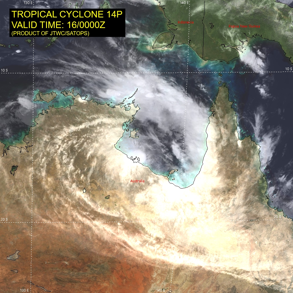
WTPS22 PGTW 151430
MSGID/GENADMIN/JOINT TYPHOON WRNCEN PEARL HARBOR HI//
SUBJ/TROPICAL CYCLONE FORMATION ALERT (INVEST 93S)//
RMKS/
1. FORMATION OF A SIGNIFICANT TROPICAL CYCLONE IS POSSIBLE WITHIN
100 NM EITHER SIDE OF A LINE FROM 15.5S 138.4E TO 18.1S 135.6E
WITHIN THE NEXT 12 TO 24 HOURS. AVAILABLE DATA DOES NOT JUSTIFY
ISSUANCE OF NUMBERED TROPICAL CYCLONE WARNINGS AT THIS TIME.
WINDS IN THE AREA ARE ESTIMATED TO BE 25 TO 30 KNOTS. METSAT
IMAGERY AT 151200Z INDICATES THAT A CIRCULATION CENTER IS LOCATED
NEAR 15.6S 138.3E. THE SYSTEM IS MOVING EASTWARD AT 02 KNOTS.
2. REMARKS:
THE AREA OF CONVECTION (INVEST 93S) PREVIOUSLY LOCATED NEAR
15.6S 137.9E IS NOW LOCATED NEAR 15.6S 138.3E, APPROXIMATELY 85 NM
NORTHWEST OF MORNINGTON ISLAND. ANIMATED ENHANCED INFRARED SATELLITE
IMAGERY AND A 151238Z GMI 89GHZ MICROWAVE PASS DEPICT SHALLOW RAIN BANDS
WRAPPING INTO A LOW LEVEL CIRCULATION CENTER (LLCC) WITH DEEP CONVECTION
PRESENT IN THE SOUTHERN QUADRANT. ENVIRONMENTAL ANALYSIS REVEALS A
FAVORABLE ENVIRONMENT FOR FURTHER DEVELOPMENT, WITH WARM (29-30C) SEA
SURFACE TEMPERATURE, GOOD RADIAL OUTFLOW ALOFT, AND LOW VERTICAL WIND
SHEAR (5-10 KTS). GLOBAL MODELS ARE IN GOOD AGREEMENT THAT 93S WILL,
AFTER A BRIEF QUASI-STATIONARY PERIOD, TRACK SOUTHWESTWARD OVER THE NEXT
24-36 HOURS. MAXIMUM SUSTAINED SURFACE WINDS ARE ESTIMATED AT 25 TO 30
KNOTS. MINIMUM SEA LEVEL PRESSURE IS ESTIMATED TO BE NEAR 996 MB. THE
POTENTIAL FOR THE DEVELOPMENT OF A SIGNIFICANT TROPICAL CYCLONE WITHIN
THE NEXT 24 HOURS IS HIGH.
3. THIS ALERT WILL BE REISSUED, UPGRADED TO WARNING OR CANCELLED BY
161430Z.//
NNNN最后于 2024-02-15 23:03:29 被666编辑 ,原因: -
IDD20150
Australian Bureau of Meteorology
Tropical Cyclone Warning Centre
Media: The Standard Emergency Warning Signal should NOT be used with this warning.
TOP PRIORITY FOR IMMEDIATE BROADCAST
TROPICAL CYCLONE ADVICE NUMBER 9
Issued at 1:16 am ACST [1:46 am AEST] on Friday 16 February 2024
Headline:
Tropical Low 07U likely to bring strong winds and heavy rainfall to the southern Gulf of Carpentaria coast ahead of expected coastal crossing on Friday.
Areas Affected:
Warning Zone
Port Roper (NT) to Burketown (Qld), including Mornington Island and Borroloola, but not including Ngukurr .
Watch Zone
None.
Cancelled Zone
None.
Details of Tropical Low at 12:30 am ACST [1:00 am AEST]:
Intensity: Tropical Low, sustained winds near the centre of 55 kilometres per hour with wind gusts to 85 kilometres per hour.
Location: within 55 kilometres of 15.6 degrees South 137.9 degrees East, estimated to be 180 kilometres east northeast of Borroloola and 185 kilometres northwest of Mornington Island.
Movement: south at 7 kilometres per hour.
Tropical Low 07U is slowly developing over the southwestern Gulf of Carpentaria. The system is forecast to move to the southwest and make landfall between the NT/Qld border and Port Roper (NT), most likely during Friday afternoon or evening. There is a moderate chance it could strengthen into a tropical cyclone on Friday ahead of the coastal crossing. Even if it doesn't develop into a tropical cyclone, parts of the Gulf of Carpentaria coast are likely to experience strong to gale force winds and heavy rainfall.
Later Friday it will weaken inland and then move west across the Northern Territory. .
Hazards:
GALES with DAMAGING WIND GUSTS to 100 kilometres per hour could develop along the coast between Bing Bong and Mornington Island during Friday morning. There is a small chance that damaging wind gusts could extend west to Port Roper in the Northern Territory or east to Burketown in Queensland during Friday depending on the movement of 07U.
HEAVY RAINFALL is expected to develop along the southern Gulf of Carpentaria coast, becoming more likely as 07U moves closer to the coast. Locally intense rainfall is also possible depending on the development of 07U.
Tides will be HIGHER THAN NORMAL across southern Gulf of Carpentaria on Friday and extending to western Gulf of Carpentaria Saturday. Large waves may produce MINOR FLOODING of low-lying coastal areas as the system nears the coast on Friday.
Recommended Action:
For people in the Northern Territory NTES advises:
- People in Borroloola and surrounding areas should activate their household plan now.
- Start preparations for a cyclone, know where you will shelter.
- Listen for the next advice.
For cyclone safety and preparation advice www.securent.nt.gov.au
Ensure family, friends and neighbours have received and understood this message.
For people in Queensland between the QLD/NT border and Burketown should consider what action they will need to take if the cyclone threat increases.
- Information is available from your local government
- For cyclone preparedness and safety advice, visit Queensland's Disaster Management Services website (www.disaster.qld.gov.au)
- For emergency assistance call the Queensland State Emergency Service (SES) on 132 500 (for assistance with storm damage, rising flood water, fallen trees on buildings or roof damage).
Next Advice:
The next advice will be issued by 4:30 am ACST Friday 16 February [5:00 am AEST Friday 16 February].
This advice is available on telephone at 1300 659 210
A map showing the track of the cyclone is available at: http://www.bom.gov.au/cyclone
Time (ACST) Intensity Category Latitude
(decimal deg.)Longitude
(decimal deg.)Estimated Position
Accuracy (km)0hr 1 am February 16 tropical low 15.6S 137.9E 55 +6hr 7 am February 16 tropical low 15.8S 137.9E 85 +12hr 1 pm February 16 tropical low 16.2S 137.8E 100 +18hr 7 pm February 16 tropical low 16.6S 137.3E 110 +24hr 1 am February 17 tropical low 16.9S 136.6E 110 +36hr 1 pm February 17 tropical low 17.4S 135.1E 115 +48hr 1 am February 18 tropical low 18.0S 133.4E 135 +60hr 1 pm February 18 tropical low 18.3S 131.6E 165 +72hr 1 am February 19 tropical low 18.7S 130.1E 200 -
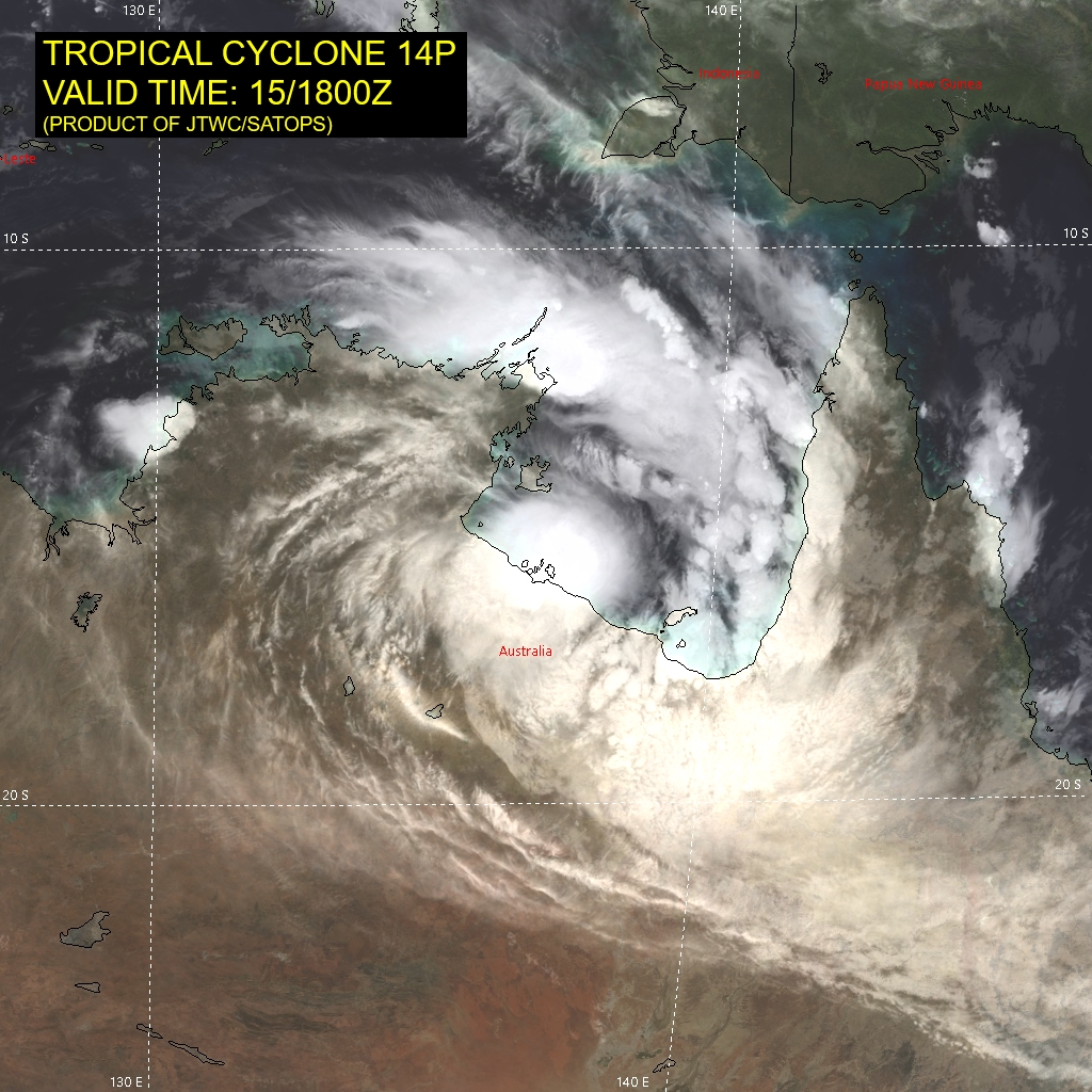
IDD20020
TROPICAL CYCLONE TECHNICAL BULLETIN: AUSTRALIA - NORTHERN REGION
Issued by AUSTRALIAN BUREAU OF METEOROLOGY TROPICAL CYCLONE WARNING CENTRE
at: 1903 UTC 15/02/2024
Name: Tropical Low
Identifier: 07U
Data At: 1800 UTC
Latitude: 15.7S
Longitude: 137.7E
Location Accuracy: within 20nm (35 km)
Movement Towards: south southwest (213 deg)
Speed of Movement: 4 knots (7 km/h)
Maximum 10-Minute Wind: 35 knots (65 km/h)
Maximum 3-Second Wind Gust: 50 knots (95 km/h)
Central Pressure: 996 hPa
Radius of 34-knot winds NE quadrant:
Radius of 34-knot winds SE quadrant:
Radius of 34-knot winds SW quadrant:
Radius of 34-knot winds NW quadrant: 50 nm (95 km)
Radius of 48-knot winds NE quadrant:
Radius of 48-knot winds SE quadrant:
Radius of 48-knot winds SW quadrant:
Radius of 48-knot winds NW quadrant:
Radius of 64-knot winds:  nm ( km)
Radius of Maximum Winds:   nm (  km)
Dvorak Intensity Code: T2.5/2.5/D1.0/24HRS  STT:D0.5/06HRS
Pressure of outermost isobar: 1004 hPa
Radius of outermost closed isobar: 150 nm (280 km)
FORECAST DATA
Date/Time    : Location    : Loc. Accuracy: Max Wind   : Central Pressure
(UTC)        : degrees     :      nm  (km): knots(km/h): hPa
+06:  16/0000: 16.1S 137.7E:     040 (070):  040  (075):  991
+12:  16/0600: 16.6S 137.4E:     050 (095):  040  (075):  991
+18:  16/1200: 16.9S 136.8E:     060 (105):  035  (065):  994
+24:  16/1800: 17.1S 136.0E:     060 (110):  030  (055):  997
+36:  17/0600: 17.6S 134.5E:     065 (120):  025  (045):  999
+48:  17/1800: 18.2S 132.7E:     075 (140):  025  (045): 1000
+60:  18/0600: 18.5S 131.0E:     100 (180):  025  (045): 1001
+72:  18/1800: 18.9S 129.4E:     110 (205):  025  (045): 1002
+96:  19/1800: 18.8S 127.3E:     145 (275):  020  (035): 1004
+120: 20/1800: 17.9S 125.2E:     185 (345):  020  (035): 1002
REMARKS:
Tropical low 07U was located using satellite and radar imagery. Deep convection
continues to increase to the west of the estimated low level centre, with the
strongest winds estimated in the northwest quadrant. Dvorak analysis yields DT
= 2.0 based on a 0.3 - 0.4 curved band wrap (3 hour average DT = 2.3). MET =
2.0 based on a 24 hour D- trend, with PT adjusted to 2.5. Final T and CI are
2.5. Intensity is set at 35 knots (NW quadrant) based on Dvorak and earlier
near gales at Centre Island, 50 nautical miles to the west of the centre. There
is no objective guidance available at present.

The environment is broadly favourable for development. SSTs in the Gulf are
very warm at 30C. An upper trough to the south of the system is providing good
upper divergence and poleward outflow. The system lies under estimated low to
moderate vertical wind shear. Some model guidance indicates 07U may reach
tropical cyclone intensity before making landfall, however remaining time over
water is limited.

Steering is expected to be to the south-southwest in the short term under the
combined influence of an upper trough to the south and mid-level ridge to the
east. On Friday night a new mid-level ridge is expecxted to build to the south
of the system, turning it more west-southwest, and this steering pattern should
persist at least over the weekend, moving the system over land across the
Northern Territory. In the longer term, guidance indicates the low may move
offshore from the Kimberley coast mid next week, with the possibility of the
system re-intensifying. There is some spread in the models at this range and a
there is a high degree of uncertainty in this outcome.

Copyright Commonwealth of Australia
==
The next bulletin for this system will be issued by: 16/0130 UTC.
Time (ACST) Intensity Category Latitude
(decimal deg.)Longitude
(decimal deg.)Estimated Position
Accuracy (km)0hr 4 am February 16 tropical low 15.7S 137.7E 35 +6hr 10 am February 16 tropical low 16.1S 137.7E 70 +12hr 4 pm February 16 tropical low 16.6S 137.4E 95 +18hr 10 pm February 16 tropical low 16.9S 136.8E 105 +24hr 4 am February 17 tropical low 17.1S 136.0E 110 +36hr 4 pm February 17 tropical low 17.6S 134.5E 120 +48hr 4 am February 18 tropical low 18.2S 132.7E 140 +60hr 4 pm February 18 tropical low 18.5S 131.0E 180 +72hr 4 am February 19 tropical low 18.9S 129.4E 205
Time (AEST) Intensity Category Latitude
(decimal deg.)Longitude
(decimal deg.)Estimated Position
Accuracy (km)0hr 4 am February 16 tropical low 15.7S 137.7E 35 +6hr 10 am February 16 tropical low 16.1S 137.7E 70 +12hr 4 pm February 16 tropical low 16.6S 137.4E 95 +18hr 10 pm February 16 tropical low 16.9S 136.8E 105 +24hr 4 am February 17 tropical low 17.1S 136.0E 110 +36hr 4 pm February 17 tropical low 17.6S 134.5E 120 +48hr 4 am February 18 tropical low 18.2S 132.7E 140 +60hr 4 pm February 18 tropical low 18.5S 131.0E 180 +72hr 4 am February 19 tropical low 18.9S 129.4E 205 -
WTPS32 PGTW 152100
MSGID/GENADMIN/JOINT TYPHOON WRNCEN PEARL HARBOR HI//
SUBJ/TROPICAL CYCLONE 14P (FOURTEEN) WARNING NR 001//
REF/A/MSG/JOINT TYPHOON WRNCEN PEARL HARBOR HI/151421ZFEB2024//
AMPN/REF A IS A TROPICAL CYCLONE FORMATION ALERT.//
RMKS/
1. TROPICAL CYCLONE 14P (FOURTEEN) WARNING NR 001
   02 ACTIVE TROPICAL CYCLONES IN SOUTHPAC
   MAX SUSTAINED WINDS BASED ON ONE-MINUTE AVERAGE
   WIND RADII VALID OVER OPEN WATER ONLY
    ---
   WARNING POSITION:
   151800Z --- NEAR 15.5S 137.5E
     MOVEMENT PAST SIX HOURS - 270 DEGREES AT 04 KTS
     POSITION ACCURATE TO WITHIN 020 NM
     POSITION BASED ON CENTER LOCATED BY A COMBINATION OF
     SATELLITE AND RADAR
   PRESENT WIND DISTRIBUTION:
   MAX SUSTAINED WINDS - 035 KT, GUSTS 045 KT
   WIND RADII VALID OVER OPEN WATER ONLY
   RADIUS OF 034 KT WINDS - 000 NM NORTHEAST QUADRANT
                            000 NM SOUTHEAST QUADRANT
                            050 NM SOUTHWEST QUADRANT
                            000 NM NORTHWEST QUADRANT
   REPEAT POSIT: 15.5S 137.5E
    ---
   FORECASTS:
   12 HRS, VALID AT:
   160600Z --- 16.1S 137.2E
   MAX SUSTAINED WINDS - 035 KT, GUSTS 045 KT
   WIND RADII VALID OVER OPEN WATER ONLY
   RADIUS OF 034 KT WINDS - 000 NM NORTHEAST QUADRANT
                            000 NM SOUTHEAST QUADRANT
                            000 NM SOUTHWEST QUADRANT
                            050 NM NORTHWEST QUADRANT
   VECTOR TO 24 HR POSIT: 240 DEG/ 06 KTS
    ---
   24 HRS, VALID AT:
   161800Z --- 16.7S 136.1E
   MAX SUSTAINED WINDS - 030 KT, GUSTS 040 KT
   WIND RADII VALID OVER OPEN WATER ONLY
   DISSIPATED AS A SIGNIFICANT TROPICAL CYCLONE OVER LAND
   VECTOR TO 36 HR POSIT: 250 DEG/ 07 KTS
    ---
   36 HRS, VALID AT:
   170600Z --- 17.2S 134.7E
   MAX SUSTAINED WINDS - 020 KT, GUSTS 030 KT
   WIND RADII VALID OVER OPEN WATER ONLY
   DISSIPATED AS A SIGNIFICANT TROPICAL CYCLONE OVER LAND
    ---
REMARKS:
152100Z POSITION NEAR 15.7S 137.4E.
15FEB24. TROPICAL CYCLONE 14P (FOURTEEN), LOCATED APPROXIMATELY
119 NM NORTHWEST OF MORNINGTON ISLAND, AUSTRALIA, HAS
TRACKED WESTWARD AT 04 KNOTS OVER THE PAST SIX HOURS.
MINIMUM CENTRAL PRESSURE AT 151800Z IS 996 MB.
MAXIMUM SIGNIFICANT WAVE HEIGHT AT 151800Z IS 12 FEET.
NEXT WARNINGS AT 160300Z, 160900Z, 161500Z AND 162100Z.
REFER TO TROPICAL CYCLONE 15P (FIFTEEN) WARNINGS (WTPS33 PGTW)
FOR SIX-HOURLY UPDATES.
2. THIS CANCELS AND SUPERSEDES REF A (WTPS22 PGTW 151430).//
NNNN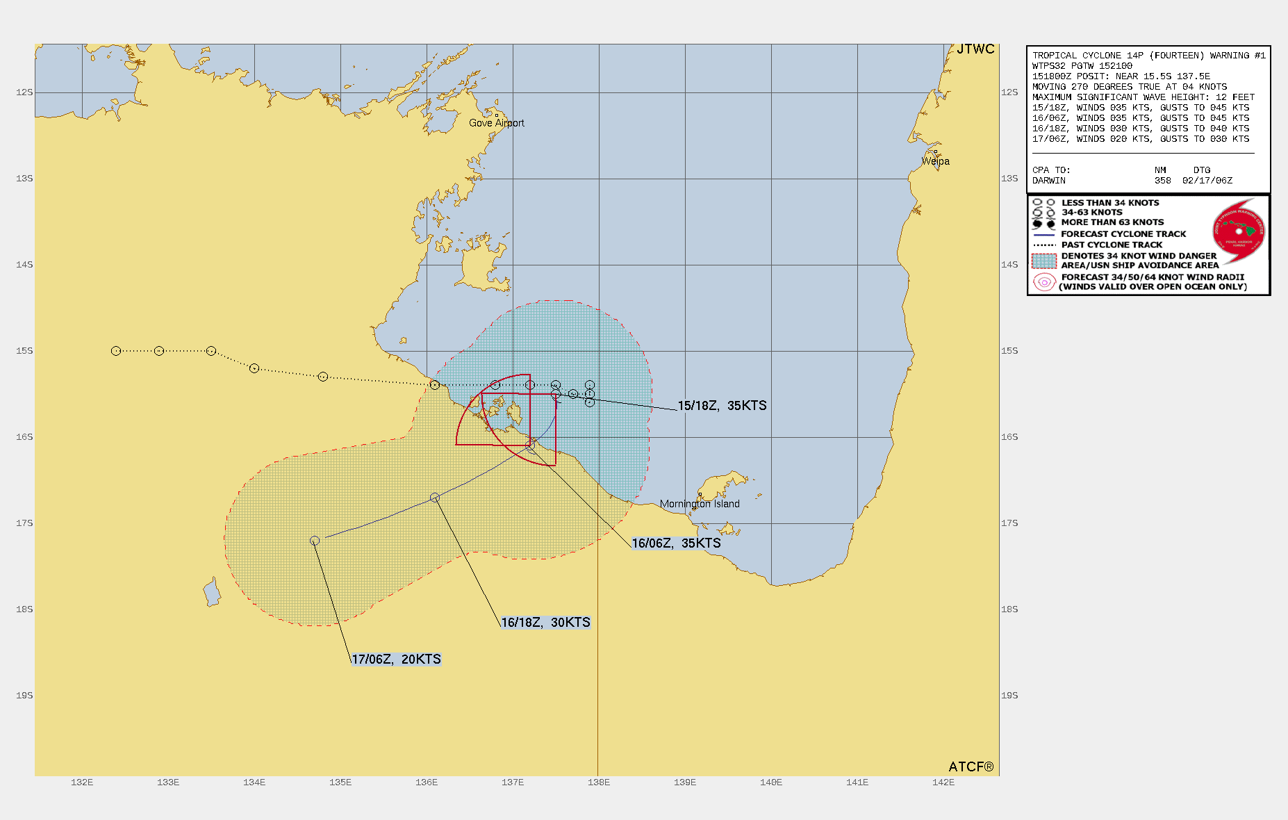
WDPS32 PGTW 152100
MSGID/GENADMIN/JOINT TYPHOON WRNCEN PEARL HARBOR HI//
SUBJ/PROGNOSTIC REASONING FOR TROPICAL CYCLONE 14P (FOURTEEN) WARNING
NR 001//
RMKS/
1. FOR METEOROLOGISTS.
2. 6 HOUR SUMMARY AND ANALYSIS.

SUMMARY:
   INITIAL POSITION: 15.5S 137.5E
   INITIAL INTENSITY: 35 KTS
   GEOGRAPHIC REFERENCE: 119 NM NORTHWEST OF MORNINGTON ISLAND,
AUSTRALIA
   MOVEMENT PAST 6 HOURS: WESTWARD AT 04 KTS
   SIGNIFICANT WAVE HEIGHT: 12 FEET

SATELLITE ANALYSIS, INITIAL POSITION AND INTENSITY DISCUSSION:
ANIMATED ENHANCED INFRARED (EIR) SATELLITE IMAGERY AND RADAR
IMAGERY FROM AUSTRALIA DEPICTS A WELL-DEFINED LOW-LEVEL CIRCULATION
CENTER (LLCC) MOVING SLOWLY 30-35 NM OFF THE AUSTRALIAN COASTLINE
IN THE SOUTHERN GULF OF CARPENTARIA. A CIRCULAR REGION OF DEEP
CONVECTION WITH CLOUD TOPS COLDER THAN -80 DEGREES CELSIUS COVERS
THE WESTERN SIDE OF THE CIRCULATION, BUT THE NORTHEASTERN QUADRANT
CONSISTS OF A DRY SLOT AND A LACK OF CONVECTION, POSSIBLY DUE TO
LIGHT NORTHERLY SHEAR APPARENT FROM UPPER-LEVEL CIRRUS CLOUD
MOTIONS. CENTRE ISLAND, LOCATED CLOSE TO THE INNERMOST CONVECTIVE
BAND ON THE WESTERN SIDE OF THE LLCC HAS BEEN MEASURING 10-MINUTE
SUSTAINED WINDS OF 30-33 KT DURING THE PAST 3 HOURS. THE INITIAL
INTENSITY IS SET AT 35 KT BASED ON THIS DATA AND AGENCY DVORAK
FIXES.

INITIAL WIND RADII BASIS: SURFACE OBSERVATIONS

CURRENT STEERING MECHANISM: SUBTROPICAL RIDGE TO THE SOUTH

AGENCY DVORAK AND AUTOMATED FIXES:
   PGTW: T2.5 - 35 KTS
   ADRM: T2.0 - 30 KTS

FORECASTER ASSESSMENT OF CURRENT ENVIRONMENT: FAVORABLE
   VWS: 5-10 KTS
   SST: 30-31 CELSIUS
   OUTFLOW: MODERATE RADIAL

ANALYSIS CONFIDENCE:
   INITIAL POSITION: HIGH
   INITIAL INTENSITY: HIGH
   INITIAL WIND RADII: MEDIUM

3. FORECAST REASONING.

SIGNIFICANT FORECAST CHANGES: THIS INITIAL PROGNOSTIC REASONING
MESSAGE ESTABLISHES THE FORECAST PHILOSOPHY.

FORECAST DISCUSSION: TROPICAL CYCLONE 14P IS CONSOLIDATING AND
ORGANIZING, BUT HAS LITTLE TIME REMAINING OVER WATER. STEERING
CURRENTS ARE PRESENTLY WEAK BETWEEN DUELING MID-LEVEL RIDGES IN THE
CORAL SEA AND OVER WESTERN AUSTRALIA, BUT MODELS ARE IN EXCELLENT
AGREEMENT THAT A LIGHT NORTHEASTERLY NET STEERING FLOW WILL BECOME
ESTABLISHED IN THE NEAR-TERM AND PUSH 14P ASHORE IN AUSTRALIA IN
ABOUT 12 HOURS. LITTLE OR NO INTENSIFICATION IS EXPECTED TO BE
POSSIBLE IN THAT TIME, GIVEN THAT A SYMMETRIC INNER CORE STRUCTURE
HAS NOT YET FORMED. HOWEVER, GIVEN THE SLOW STORM MOTION, IT IS
POSSIBLE THAT 14P SPENDS SLIGHTLY LONGER OVER WATER THAN EXPECTED,
POTENTIALLY LEADING TO SOME INTENSIFICATION PRIOR TO LANDFALL.
POST-LANDFALL, 14P WILL DISSIPATE, AND THE SUBTROPICAL RIDGE OVER
SOUTHERN AUSTRALIA WILL TURN 14P'S REMNANTS WESTWARD ACROSS
NORTHERN AUSTRALIA, POTENTIALLY REEMERGING OVER WATER IN THE
SOUTHEASTERN INDIAN OCEAN IN SEVERAL DAYS. SHOULD THIS OCCUR, THE
REMNANTS WOULD BE MONITORED FOR REGENERATION.

MODEL DISCUSSION: DYNAMICAL MODELS ARE IN GOOD AGREEMENT DURING THE
SHORT FORECAST PERIOD. THE JTWC TRACK AND INTENSITY FORECASTS ARE
CLOSE TO THE MULTI-MODEL CONSENSUS.

FORECAST CONFIDENCE:
   TRACK 0 - 72 HR: HIGH
   INTENSITY 0 - 72 HR: MEDIUM//
NNNN
-
IDD20150
Australian Bureau of Meteorology
Tropical Cyclone Warning Centre
Media: The Standard Emergency Warning Signal should NOT be used with this warning.
TOP PRIORITY FOR IMMEDIATE BROADCAST
TROPICAL CYCLONE ADVICE NUMBER 11
Issued at 7:01 am ACST [7:31 am AEST] on Friday 16 February 2024
Headline:
Tropical Low 07U likely to bring strong winds and heavy rainfall to the southern Gulf of Carpentaria coast ahead of expected coastal crossing today.
Areas Affected:
Warning Zone
Port Roper (NT) to Burketown (Qld), including Mornington Island and Borroloola, but not including Ngukurr .
Watch Zone
None.
Cancelled Zone
None.
Details of Tropical Low at 6:30 am ACST [7:00 am AEST]:
Intensity: Tropical Low, sustained winds near the centre of 65 kilometres per hour with wind gusts to 95 kilometres per hour.
Location: within 35 kilometres of 15.7 degrees South 137.7 degrees East, estimated to be 155 kilometres east northeast of Borroloola and 190 kilometres northwest of Mornington Island.
Movement: slow moving.
Tropical Low 07U is slowly developing over the southwestern Gulf of Carpentaria. The system is forecast to move to the southwest and make landfall between the NT/Qld border and Port McArthur (NT), most likely this afternoon. There is a moderate chance it could strengthen into a tropical cyclone ahead of the coastal crossing. Even if it does not develop into a tropical cyclone, parts of the Gulf of Carpentaria coast are likely to experience strong to gale force winds and heavy rainfall later today.
Tonight the system is expected to weaken inland, and then move west across the Northern Territory over the weekend.
Hazards:
GALES with DAMAGING WIND GUSTS to 100 kilometres per hour could develop along the coast between Bing Bong and Mornington Island this morning. There is a small chance that damaging wind gusts could extend west to Port Roper in the Northern Territory or east to Burketown in Queensland later today, depending on the movement of 07U.
HEAVY RAINFALL is expected to develop along the southern Gulf of Carpentaria coast today, becoming more likely as 07U moves closer to the coast. Locally intense rainfall is also possible depending on the development of 07U.
Tides will be HIGHER THAN NORMAL across the southern Gulf of Carpentaria today and on Saturday. Large waves may produce MINOR FLOODING of low-lying coastal areas as the system nears the coast on Friday.
Recommended Action:
For people in the Northern Territory NTES advises:
- People in Borroloola and surrounding areas should activate their household plan now.
- Start preparations for a cyclone, know where you will shelter.
- Listen for the next advice.
For cyclone safety and preparation advice www.securent.nt.gov.au
Ensure family, friends and neighbours have received and understood this message.
People in Queensland between the QLD/NT border and Burketown should take precautions and listen to the next advice.
- Information is available from your local government
- For cyclone preparedness and safety advice, visit Queensland's Disaster Management Services website (www.disaster.qld.gov.au)
- For emergency assistance call the Queensland State Emergency Service (SES) on 132 500 (for assistance with storm damage, rising flood water, fallen trees on buildings or roof damage).
Next Advice:
The next advice will be issued by 10:30 am ACST Friday 16 February [11:00 am AEST Friday 16 February].
This advice is available on telephone at 1300 659 210
A map showing the track of the cyclone is available at: http://www.bom.gov.au/cyclone
Time (ACST) Intensity Category Latitude
(decimal deg.)Longitude
(decimal deg.)Estimated Position
Accuracy (km)0hr 7 am February 16 tropical low 15.7S 137.7E 35 +6hr 1 pm February 16 tropical low 16.0S 137.6E 65 +12hr 7 pm February 16 tropical low 16.5S 137.4E 85 +18hr 1 am February 17 tropical low 16.8S 136.8E 95 +24hr 7 am February 17 tropical low 17.1S 136.1E 100 +36hr 7 pm February 17 tropical low 17.6S 134.7E 110 +48hr 7 am February 18 tropical low 18.0S 133.0E 135 +60hr 7 pm February 18 tropical low 18.2S 131.8E 165 +72hr 7 am February 19 tropical low 18.5S 130.4E 190 -
IDD20020
TROPICAL CYCLONE TECHNICAL BULLETIN: AUSTRALIA - NORTHERN REGION
Issued by AUSTRALIAN BUREAU OF METEOROLOGY TROPICAL CYCLONE WARNING CENTRE
at: 0101 UTC 16/02/2024
Name: Tropical Low
Identifier: 07U
Data At: 0000 UTC
Latitude: 15.6S
Longitude: 137.6E
Location Accuracy: within 15nm (30 km)
Movement Towards: west (270 deg)
Speed of Movement: 2 knots (4 km/h)
Maximum 10-Minute Wind: 35 knots (65 km/h)
Maximum 3-Second Wind Gust: 50 knots (95 km/h)
Central Pressure: 996 hPa
Radius of 34-knot winds NE quadrant:
Radius of 34-knot winds SE quadrant:
Radius of 34-knot winds SW quadrant:
Radius of 34-knot winds NW quadrant: 50 nm (95 km)
Radius of 48-knot winds NE quadrant:
Radius of 48-knot winds SE quadrant:
Radius of 48-knot winds SW quadrant:
Radius of 48-knot winds NW quadrant:
Radius of 64-knot winds:  nm ( km)
Radius of Maximum Winds:   nm (  km)
Dvorak Intensity Code: T2.0/2.5/S0.0/24HRS STT:0.5/06HRS
Pressure of outermost isobar: 1004 hPa
Radius of outermost closed isobar: 200 nm (370 km)
FORECAST DATA
Date/Time    : Location    : Loc. Accuracy: Max Wind   : Central Pressure
(UTC)        : degrees     :      nm  (km): knots(km/h): hPa
+06:  16/0600: 16.2S 137.5E:     035 (065):  040  (075):  994
+12:  16/1200: 16.6S 137.2E:     045 (085):  030  (055):  998
+18:  16/1800: 16.9S 136.5E:     055 (100):  030  (055):  999
+24:  17/0000: 17.1S 135.8E:     060 (110):  030  (055):  999
+36:  17/1200: 17.7S 134.4E:     065 (120):  025  (045): 1002
+48:  18/0000: 18.0S 132.7E:     075 (140):  025  (045): 1004
+60:  18/1200: 18.3S 131.5E:     095 (175):  025  (045): 1003
+72:  19/0000: 18.4S 130.1E:     105 (190):  025  (045): 1003
+96:  20/0000: 17.5S 128.5E:     135 (250):  020  (035): 1003
+120: 21/0000: 16.6S 127.0E:     180 (335):  020  (035): 1003
REMARKS:
Tropical low 07U was located using visible satellite imagery and radar
animation. Deep convection has continued to persist to the west and northwest
of the centre. The low level centre is exposed about 25nm to the east of the
deepest convection.

Dvorak analysis using curved band pattern yields DT = 2.0. MET = 1.5 based on a
24 hour S trend, with PT adjusted to 2.0. Final T = 2.0 and CI is held at 2.5.
Shear pattern has not been used due to the pulsating nature of deep convection.
Intensity is set at 35 knots (NW quadrant) based on observations. There is no
objective guidance available at present.

The environment is broadly favourable for development. An upper trough to the
south of the system is providing good upper divergence and poleward outflow.
The system lies under estimated low to moderate vertical wind shear. Some model
guidance indicates 07U may reach tropical cyclone intensity just before making
landfall, however remaining time over water is limited.

Steering is expected to be to the south-southwest under the combined influence
of an upper trough to the south and mid-level ridge to the east. From late
Friday, a new mid-level ridge builds to the south of the system, turning it
more towards the west-southwest. This steering should persist during the
weekend, moving the system over land across central Northern Territory. In the
longer term, guidance indicates the low may move offshore from the Kimberley
coast mid next week, with the possibility of the system re-intensifying.

Copyright Commonwealth of Australia
==
The next bulletin for this system will be issued by: 16/0730 UTC.
Time (ACST) Intensity Category Latitude
(decimal deg.)Longitude
(decimal deg.)Estimated Position
Accuracy (km)0hr 10 am February 16 tropical low 15.6S 137.6E 30 +6hr 4 pm February 16 tropical low 16.2S 137.5E 65 +12hr 10 pm February 16 tropical low 16.6S 137.2E 85 +18hr 4 am February 17 tropical low 16.9S 136.5E 100 +24hr 10 am February 17 tropical low 17.1S 135.8E 110 +36hr 10 pm February 17 tropical low 17.7S 134.4E 120 +48hr 10 am February 18 tropical low 18.0S 132.7E 140 +60hr 10 pm February 18 tropical low 18.3S 131.5E 175 +72hr 10 am February 19 tropical low 18.4S 130.1E 190

Time (AEST) Intensity Category Latitude
(decimal deg.)Longitude
(decimal deg.)Estimated Position
Accuracy (km)0hr 10 am February 16 tropical low 15.6S 137.6E 30 +6hr 4 pm February 16 tropical low 16.2S 137.5E 65 +12hr 10 pm February 16 tropical low 16.6S 137.2E 85 +18hr 4 am February 17 tropical low 16.9S 136.5E 100 +24hr 10 am February 17 tropical low 17.1S 135.8E 110 +36hr 10 pm February 17 tropical low 17.7S 134.4E 120 +48hr 10 am February 18 tropical low 18.0S 132.7E 140 +60hr 10 pm February 18 tropical low 18.3S 131.5E 175 +72hr 10 am February 19 tropical low 18.4S 130.1E 190 -
WTPS32 PGTW 160300
MSGID/GENADMIN/JOINT TYPHOON WRNCEN PEARL HARBOR HI//
SUBJ/TROPICAL CYCLONE 14P (FOURTEEN) WARNING NR 002//
RMKS/
1. TROPICAL CYCLONE 14P (FOURTEEN) WARNING NR 002
   02 ACTIVE TROPICAL CYCLONES IN SOUTHPAC
   MAX SUSTAINED WINDS BASED ON ONE-MINUTE AVERAGE
   WIND RADII VALID OVER OPEN WATER ONLY
    ---
   WARNING POSITION:
   160000Z --- NEAR 15.5S 137.5E
     MOVEMENT PAST SIX HOURS - 360 DEGREES AT 00 KTS
     POSITION ACCURATE TO WITHIN 020 NM
     POSITION BASED ON CENTER LOCATED BY A COMBINATION OF
     SATELLITE AND RADAR
   PRESENT WIND DISTRIBUTION:
   MAX SUSTAINED WINDS - 035 KT, GUSTS 045 KT
   WIND RADII VALID OVER OPEN WATER ONLY
   RADIUS OF 034 KT WINDS - 000 NM NORTHEAST QUADRANT
                            000 NM SOUTHEAST QUADRANT
                            050 NM SOUTHWEST QUADRANT
                            050 NM NORTHWEST QUADRANT
   REPEAT POSIT: 15.5S 137.5E
    ---
   FORECASTS:
   12 HRS, VALID AT:
   161200Z --- 16.1S 136.8E
   MAX SUSTAINED WINDS - 030 KT, GUSTS 040 KT
   WIND RADII VALID OVER OPEN WATER ONLY
   DISSIPATING AS A SIGNIFICANT TROPICAL CYCLONE OVER LAND
   VECTOR TO 24 HR POSIT: 245 DEG/ 07 KTS
    ---
   24 HRS, VALID AT:
   170000Z --- 16.7S 135.5E
   MAX SUSTAINED WINDS - 025 KT, GUSTS 035 KT
   WIND RADII VALID OVER OPEN WATER ONLY
   DISSIPATING AS A SIGNIFICANT TROPICAL CYCLONE OVER LAND
   VECTOR TO 36 HR POSIT: 250 DEG/ 07 KTS
    ---
   36 HRS, VALID AT:
   171200Z --- 17.2S 134.2E
   MAX SUSTAINED WINDS - 020 KT, GUSTS 030 KT
   WIND RADII VALID OVER OPEN WATER ONLY
   DISSIPATED AS A SIGNIFICANT TROPICAL CYCLONE OVER LAND
    ---
REMARKS:
160300Z POSITION NEAR 15.7S 137.3E.
16FEB24. TROPICAL CYCLONE 14P (FOURTEEN), LOCATED APPROXIMATELY
119 NM NORTHWEST OF MORNINGTON ISLAND, AUSTRALIA, HAS TRACKED
NORTHWARD AT 00 KNOTS OVER THE PAST SIX HOURS.
MINIMUM CENTRAL PRESSURE AT 160000Z IS 996 MB. MAXIMUM
SIGNIFICANT WAVE HEIGHT AT 160000Z IS 12 FEET. NEXT WARNINGS AT
160900Z, 161500Z, 162100Z AND 170300Z.
REFER TO TROPICAL CYCLONE 15P (FIFTEEN) WARNINGS (WTPS33 PGTW)
FOR SIX-HOURLY UPDATES.
//
NNNN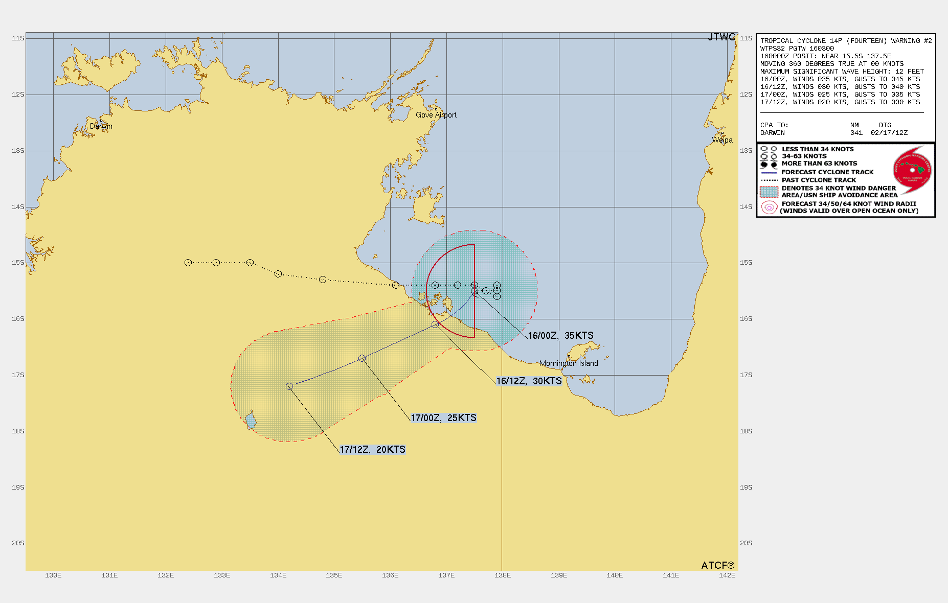
WDPS32 PGTW 160300
MSGID/GENADMIN/JOINT TYPHOON WRNCEN PEARL HARBOR HI//
SUBJ/PROGNOSTIC REASONING FOR TROPICAL CYCLONE 14P (FOURTEEN) WARNING
NR 002//
RMKS/
1. FOR METEOROLOGISTS.
2. 6 HOUR SUMMARY AND ANALYSIS.

SUMMARY:
   INITIAL POSITION: 15.5S 137.5E
   INITIAL INTENSITY: 35 KTS
   GEOGRAPHIC REFERENCE: 119 NM NORTHWEST OF MORNINGTON ISLAND,
AUSTRALIA
   MOVEMENT PAST 6 HOURS: NORTHWARD AT 00 KTS
   SIGNIFICANT WAVE HEIGHT: 12 FEET

SATELLITE ANALYSIS, INITIAL POSITION AND INTENSITY DISCUSSION:
ANIMATED MULTISPECTRAL SATELLITE IMAGERY (MSI) DEPICTS A COMPACT
BUT PARTIALLY EXPOSED LOW-LEVEL CIRCULATION WITH CORE CONVECTION
CONFINED TO THE WESTERN SIDE. NORTHERLY OR NORTHEASTERLY SHEAR IS
EVIDENT IN SATELLITE IMAGERY WITH UPPER-LEVEL CIRRUS CLOUDS
STREAMING INTO THE LLC LOCATION FROM THE NORTHEAST. THE STORM HAS
BEEN QUASISTATIONARY OVER THE PAST SIX HOURS. THE INITIAL INTENSITY
IS HELD AT 35 KT BASED ON AGENCY DVORAK ESTIMATES OF T2.5 (35 KT)
AND LITTLE CHANGE IN OBSERVED SURFACE WINDS AT CENTRE ISLAND NEAR
THE DEEP CONVECTION ON THE WESTERN SIDE OF THE LLC, RANGING FROM 30
TO 33 KT (10-MINUTE AVERAGED) IN RECENT HOURS.

INITIAL WIND RADII BASIS: PERSISTENCE

CURRENT STEERING MECHANISM: MID-LEVEL RIDGES TO THE SOUTHWEST AND
EAST

AGENCY DVORAK AND AUTOMATED FIXES:
   PGTW: T2.5 - 35 KTS

FORECASTER ASSESSMENT OF CURRENT ENVIRONMENT: MARGINAL
   VWS: 15-20 KTS
   SST: 30-31 CELSIUS
   OUTFLOW: MODERATE RADIAL

ANALYSIS CONFIDENCE:
   INITIAL POSITION: HIGH
   INITIAL INTENSITY: HIGH
   INITIAL WIND RADII: MEDIUM

3. FORECAST REASONING.

SIGNIFICANT FORECAST CHANGES: THERE ARE NO SIGNIFICANT CHANGES TO
THE FORECAST FROM THE PREVIOUS WARNING.

FORECAST DISCUSSION: TROPICAL CYCLONE 14P HAS BEEN QUASISTATIONARY
FOR THE PAST SIX HOURS, MIRED IN WEAK STEERING CURRENTS BETWEEN TWO
MID-LEVEL RIDGES OVER WESTERN AUSTRALIA AND THE CORAL SEA. HOWEVER,
MODELS REMAIN IN AGREEMENT THAT A NET NORTHEASTERLY STEERING FLOW
WILL DEVELOP SHORTLY AND PUSH 14P SOUTHWESTWARD AND INLAND OVER
NORTHERN AUSTRALIA WITHIN THE NEXT 12 HOURS. DISSIPATION AND A
SUBSEQUENT TRACK OF THE REMNANTS WESTWARD ACROSS NORTHERN AUSTRALIA
WILL ENSUE. THIS TRACK COULD POTENTIALLY CARRY THE REMNANTS OUT
INTO THE SOUTHEAST INDIAN OCEAN IN SEVERAL DAYS, AT WHICH POINT
MODELS SUGGEST REGENERATION IS POSSIBLE. SHOULD THE REMNANTS IN
FACT SURVIVE AND REEMERGE OVER WATER, THEY WILL BE MONITORED FOR
REGENERATION.

MODEL DISCUSSION: DYNAMICAL MODEL GUIDANCE IS IN GOOD AGREEMENT ON
THE STORM TRACK DURING THE FORECAST PERIOD, AND THE JTWC FORECAST
IS CLOSE TO THE MULTI-MODEL CONSENSUS. THE JTWC INTENSITY FORECAST
IS CLOSE TO THE MEAN OF THE OVERLAND DECAY FORECAST FROM AVAILABLE
GLOBAL MODELS.

FORECAST CONFIDENCE:
   TRACK 0 - 72 HR: HIGH
   INTENSITY 0 - 72 HR: HIGH//
NNNN
-
IDD20150
Australian Bureau of Meteorology
Tropical Cyclone Warning CentreMedia: The Standard Emergency Warning Signal should NOT be used with this warning.
TOP PRIORITY FOR IMMEDIATE BROADCAST
TROPICAL CYCLONE ADVICE NUMBER 13
Issued at 12:22 pm ACST [12:52 pm AEST] on Friday 16 February 2024Headline:
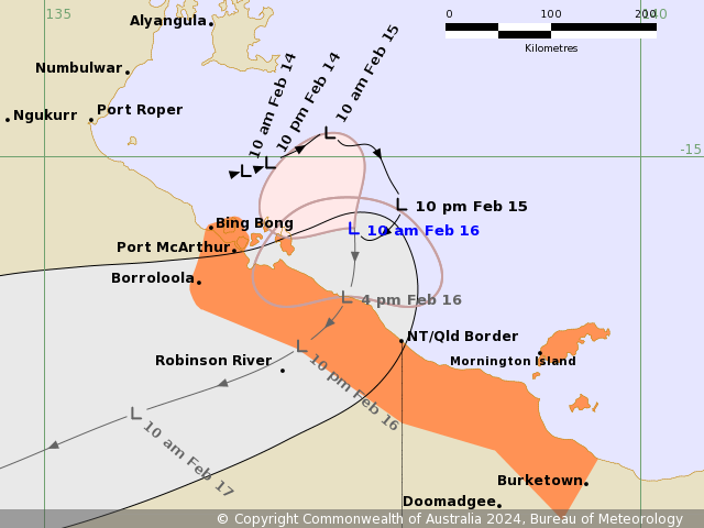
Tropical Cyclone Lincoln has formed in the southern Gulf of Carpentaria. A coastal crossing is expected between Port McArthur and the NT/Qld Border during the afternoon.Areas Affected:
Warning Zone
Bing Bong (NT) to Mornington Island (Qld), including Borroloola, Port McArthur and Mornington Island.Watch Zone
None.Cancelled Zone
Mornington Island to Burketown.Details of Tropical Cyclone Lincoln at 11:30 am ACST [12:00 pm AEST]:
Intensity: Category 1, sustained winds near the centre of 75 kilometres per hour with wind gusts to 100 kilometres per hour.Location: within 20 kilometres of 15.6 degrees South 137.5 degrees East, estimated to be 140 kilometres east northeast of Borroloola and 220 kilometres northwest of Mornington Island.
Movement: slow moving.
Tropical Cyclone Lincoln formed this morning, and will move to the south to southwest over the southern Gulf of Carpentaria this afternoon. It is forecast to make landfall between the NT/Qld border and Port McArthur (NT) this afternoon as a category 1 cyclone.
As it moves inland tonight, the system is expected to quickly weaken below tropical cyclone intensity. It will then begin moving west across the Northern Territory over the weekend.
Hazards:
GALES with DAMAGING WIND GUSTS to 110 kilometres per hour are expected to develop along the coast between Bing Bong and Mornington Island during the day as Tropical Cyclone Lincoln approaches and crosses the coast.HEAVY RAINFALL is expected along the southern Gulf of Carpentaria coast. Locally intense rainfall is also possible.
Refer to separate Flood watches and warnings, as well as the Severe Weather Warning.
Tides will be HIGHER THAN NORMAL across the southern Gulf of Carpentaria today and Saturday. Large waves may produce MINOR FLOODING of low-lying coastal areas as the system nears the coast on Friday.
Recommended Action:
For people in the Northern Territory NTES advises:-People in Borroloola and surrounding areas should have completed their preparations.
For cyclone safety and preparation advice www.securent.nt.gov.au
Ensure family, friends and neighbours have received and understood this message.
People in Queensland between the QLD/NT border and Burketown should take precautions and listen to the next advice.
- Information is available from your local government
- For cyclone preparedness and safety advice, visit Queensland's Disaster Management Services website (www.disaster.qld.gov.au)
- For emergency assistance call the Queensland State Emergency Service (SES) on 132 500 (for assistance with storm damage, rising flood water, fallen trees on buildings or roof damage).
Next Advice:
The next advice will be issued by 1:30 pm ACST Friday 16 February [2:00 pm AEST Friday 16 February].This advice is available on telephone at 1300 659 210
A map showing the track of the cyclone is available at: http://www.bom.gov.au/cyclone
Time (ACST) Intensity Category Latitude
(decimal deg.)Longitude
(decimal deg.)Estimated Position
Accuracy (km)0hr 12 pm February 16 1 15.6S 137.5E 20 +6hr 6 pm February 16 1 16.0S 137.3E 50 +12hr 12 am February 17 tropical low 16.4S 136.9E 70 +18hr 6 am February 17 tropical low 16.7S 136.2E 85 +24hr 12 pm February 17 tropical low 16.9S 135.5E 100 +36hr 12 am February 18 tropical low 17.5S 134.0E 130 +48hr 12 pm February 18 tropical low 17.8S 132.4E 165 +60hr 12 am February 19 tropical low 18.0S 131.2E 190 +72hr 12 pm February 19 tropical low 18.0S 129.8E 205