Media: The Standard Emergency Warning Signal should NOT be used with this warning.
TOP PRIORITY FOR IMMEDIATE BROADCAST
TROPICAL CYCLONE ADVICE NUMBER 14
Issued at 1:06 pm ACST [1:36 pm AEST] on Friday 16 February 2024
Headline:
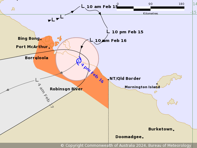
Tropical Cyclone Lincoln formed this morning in the southern Gulf of Carpentaria. A coastal crossing is expected between Port McArthur and the NT/Qld Border during the late afternoon or evening.
Areas Affected:
Warning Zone
Bing Bong (NT) to Mornington Island (Qld), including Borroloola, Port McArthur and Mornington Island.
Watch Zone
None.
Cancelled Zone
None.
Details of Tropical Cyclone Lincoln at 12:30 pm ACST [1:00 pm AEST]:
Intensity: Category 1, sustained winds near the centre of 75 kilometres per hour with wind gusts to 100 kilometres per hour.
Location: within 20 kilometres of 15.7 degrees South 137.4 degrees East, estimated to be 125 kilometres east northeast of Borroloola and 220 kilometres west northwest of Mornington Island.
Movement: slow moving.
Tropical Cyclone Lincoln will move to the south to southwest over the southern Gulf of Carpentaria this afternoon. It is forecast to make landfall between the NT/Qld border and Port McArthur (NT) later this afternoon or evening as a category 1 cyclone.
As it moves inland tonight, the system is expected to quickly weaken below tropical cyclone intensity. It will then begin moving west across the Northern Territory over the weekend.
Hazards:
GALES with DAMAGING WIND GUSTS to 110 kilometres per hour are expected to develop along the coast between Bing Bong and Mornington Island as Tropical Cyclone Lincoln approaches and crosses the coast.
HEAVY RAINFALL is expected along the southern Gulf of Carpentaria coast. Locally intense rainfall is also possible. Refer to separate Flood watches and warnings, as well as the Severe Weather Warning.
Tides will be HIGHER THAN NORMAL across the southern Gulf of Carpentaria today and Saturday. Large waves may produce MINOR FLOODING of low-lying coastal areas as the system nears the coast on Friday.
Recommended Action:
For people in the Northern Territory NTES advises:
-People in Borroloola and surrounding areas should stay calm and remain inside while dangerous winds and rain continue.
-Do not go outside if you find you are in the eye of the cyclone.
-Follow the advice and instructions of local police, emergency services and authorities
For cyclone safety and preparation advice www.securent.nt.gov.au
Ensure family, friends and neighbours have received and understood this message.
People in Queensland between the QLD/NT border and Burketown should take precautions and listen to the next advice.
- Information is available from your local government
- For cyclone preparedness and safety advice, visit Queensland's Disaster Management Services website (www.disaster.qld.gov.au)
- For emergency assistance call the Queensland State Emergency Service (SES) on 132 500 (for assistance with storm damage, rising flood water, fallen trees on buildings or roof damage).
Next Advice:
The next advice will be issued by 4:30 pm ACST Friday 16 February [5:00 pm AEST Friday 16 February].
This advice is available on telephone at 1300 659 210
IDD20020
TROPICAL CYCLONE TECHNICAL BULLETIN: AUSTRALIA - NORTHERN REGION
Issued by AUSTRALIAN BUREAU OF METEOROLOGY TROPICAL CYCLONE WARNING CENTRE
at: 0650 UTC 16/02/2024
Name: Tropical Cyclone Lincoln
Identifier: 07U
Data At: 0600 UTC
Latitude: 16.1S
Longitude: 137.3E
Location Accuracy: within 10nm (20 km)
Movement Towards: south southwest (210 deg)
Speed of Movement: 6 knots (11 km/h)
Maximum 10-Minute Wind: 40 knots (75 km/h)
Maximum 3-Second Wind Gust: 55 knots (100 km/h)
Central Pressure: 993 hPa
Radius of 34-knot winds NE quadrant: 30 nm (55 km)
Radius of 34-knot winds SE quadrant: 25 nm (45 km)
Radius of 34-knot winds SW quadrant: 30 nm (55 km)
Radius of 34-knot winds NW quadrant: 35 nm (65 km)
Radius of 48-knot winds NE quadrant:
Radius of 48-knot winds SE quadrant:
Radius of 48-knot winds SW quadrant:
Radius of 48-knot winds NW quadrant:
Radius of 64-knot winds:  nm ( km)
Radius of Maximum Winds: 15 nm (30 km)
Dvorak Intensity Code: T3.0/3.0/D1.5/24HRS STT:D1.0/06HRS
Pressure of outermost isobar: 1006 hPa
Radius of outermost closed isobar: 220 nm (405 km)
FORECAST DATA
Date/Time    : Location    : Loc. Accuracy: Max Wind   : Central Pressure
(UTC)        : degrees     :      nm  (km): knots(km/h): hPa
+06:  16/1200: 16.3S 137.1E:     030 (050):  030  (055):  996
+12:  16/1800: 16.5S 136.3E:     040 (075):  030  (055):  996
+18:  17/0000: 16.8S 135.5E:     050 (090):  030  (055): 1000
+24:  17/0600: 17.1S 134.9E:     055 (105):  025  (045):  998
+36:  17/1800: 17.6S 133.3E:     070 (130):  025  (045): 1000
+48:  18/0600: 18.0S 131.8E:     095 (180):  025  (045): 1001
+60:  18/1800: 18.2S 130.4E:     115 (210):  025  (045): 1001
+72:  19/0600: 18.0S 129.1E:     125 (235):  025  (045): 1000
+96:  20/0600: 16.9S 127.0E:     155 (290):  020  (035): 1000
+120: 21/0600: 16.0S 124.8E:     190 (355):  025  (045):  998
REMARKS:
Tropical Cyclone Lincoln was located using visible satellite imagery, radar
animation and nearby surface observations. Deep convection has continued just
to the west of the centre. The exposed low level centre is now less than 10nm
to the east of the deepest convection.

Dvorak analysis based on shear pattern yields DT = 3.5. MET = 2.5 based on a 24
hour D trend, with PT adjusted to 3.0. Final T and CI = 3.0. Objective
Guidance: AiDT 33kn, DPRINT 34 kn (1-min). Intensity is 40 knots based on
earlier ASCAT pass and Dvorak analysis.

The system is expected to maintain intensity as it makes landfall, then weaken
quickly to below tropical cyclone strength during the evening.

Steering is expected to continue to be south-southwest initially, then more
towards the west-southwest during the weekend as a mid-level ridge builds to
the south. It is then expected to maintain a general westward movement into
early next week, moving across central Northern Territory. In the longer term,
guidance indicates the low may move offshore of the Kimberley coast by mid next
week, with the possibility of the system re-intensifying.

Copyright Commonwealth of Australia
==
There will be no further bulletins for this system unless it reintensifies.
Media: The Standard Emergency Warning Signal should NOT be used with this warning.
TOP PRIORITY FOR IMMEDIATE BROADCAST
TROPICAL CYCLONE ADVICE NUMBER 15 [Updated - Recommended Action statements]
Issued at 4:31 pm ACST [5:01 pm AEST] on Friday 16 February 2024
Headline:
Tropical Cyclone Lincoln is crossing the southern Gulf of Carpentaria coast between Port McArthur and the NT/Qld Border.
Areas Affected:
Warning Zone
Bing Bong (NT) to NT/Qld Border, including Borroloola and Port McArthur .
Watch Zone
None.
Cancelled Zone
NT/Qld Border to Mornington Island (Qld).
Details of Tropical Cyclone Lincoln at 3:30 pm ACST [4:00 pm AEST]:
Intensity: Category 1, sustained winds near the centre of 75 kilometres per hour with wind gusts to 100 kilometres per hour.
Location: within 20 kilometres of 16.1 degrees South 137.3 degrees East, estimated to be 105 kilometres east of Borroloola and 215 kilometres west northwest of Mornington Island.
Movement: south southwest at 11 kilometres per hour.
Tropical Cyclone Lincoln will continue to move inland after it crosses the coast. It is forecast to weaken below tropical cyclone intensity during this evening. Lincoln will then move west across the central Northern Territory during the weekend.
Hazards:
GALES with DAMAGING WIND GUSTS to 110 kilometres per hour are expected along the coast between Bing Bong and NT/Qld Border during the afternoon and evening.
HEAVY RAINFALL is expected along the southern Gulf of Carpentaria coast with LOCALLY INTENSE RAINFALL possible around Lincoln's centre. Refer to separate Flood watches and warnings, as well as the Severe Weather Warning.
Tides will be HIGHER THAN NORMAL across the southern Gulf of Carpentaria today and Saturday. Large waves may produce MINOR FLOODING of low-lying coastal areas as the Lincoln crosses the coast.
Recommended Action:
NTES advises:
- People near Borroloola and surrounding areas should stay alert and prepared
- Your property should now be prepared
- Possible disruption to essential supplies
- Follow the advice and instructions of local police, emergency services and authorities
- Listen for the next advice.
For cyclone safety and preparation advice www.securent.nt.gov.au
Ensure family, friends and neighbours have received and understood this message.
Next Advice:
The next advice will be issued by 7:30 pm ACST Friday 16 February [8:00 pm AEST Friday 16 February].
This advice is available on telephone at 1300 659 210
WTPS32 PGTW 160900
MSGID/GENADMIN/JOINT TYPHOON WRNCEN PEARL HARBOR HI//
SUBJ/TROPICAL CYCLONE 14P (LINCOLN) WARNING NR 003//
RMKS/
1. TROPICAL CYCLONE 14P (LINCOLN) WARNING NR 003
02 ACTIVE TROPICAL CYCLONES IN SOUTHPAC
MAX SUSTAINED WINDS BASED ON ONE-MINUTE AVERAGE
WIND RADII VALID OVER OPEN WATER ONLY
---
WARNING POSITION:
160600Z --- NEAR 16.2S 137.1E
MOVEMENT PAST SIX HOURS - 210 DEGREES AT 08 KTS
POSITION ACCURATE TO WITHIN 015 NM
POSITION BASED ON CENTER LOCATED BY A COMBINATION OF
SATELLITE, RADAR AND SYNOPTIC DATA
PRESENT WIND DISTRIBUTION:
MAX SUSTAINED WINDS - 035 KT, GUSTS 045 KT
WIND RADII VALID OVER OPEN WATER ONLY
DISSIPATING AS A SIGNIFICANT TROPICAL CYCLONE OVER LAND
RADIUS OF 034 KT WINDS - 025 NM NORTHEAST QUADRANT
030 NM SOUTHEAST QUADRANT
025 NM SOUTHWEST QUADRANT
025 NM NORTHWEST QUADRANT
REPEAT POSIT: 16.2S 137.1E
---
FORECASTS:
12 HRS, VALID AT:
161800Z --- 16.7S 136.0E
MAX SUSTAINED WINDS - 030 KT, GUSTS 040 KT
WIND RADII VALID OVER OPEN WATER ONLY
DISSIPATED AS A SIGNIFICANT TROPICAL CYCLONE OVER LAND
VECTOR TO 24 HR POSIT: 245 DEG/ 07 KTS
---
24 HRS, VALID AT:
170600Z --- 17.3S 134.6E
MAX SUSTAINED WINDS - 025 KT, GUSTS 035 KT
WIND RADII VALID OVER OPEN WATER ONLY
DISSIPATED AS A SIGNIFICANT TROPICAL CYCLONE OVER LAND
---
REMARKS:
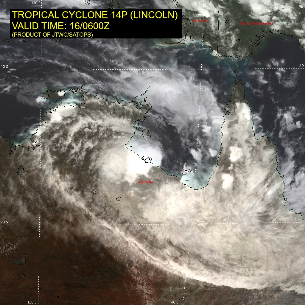
160900Z POSITION NEAR 16.3S 136.8E.
16FEB24. TROPICAL CYCLONE 14P (LINCOLN), LOCATED APPROXIMATELY
423 NM EAST-SOUTHEAST OF DARWIN, AUSTRALIA, HAS TRACKED SOUTH-
SOUTHWESTWARD AT 08 KNOTS OVER THE PAST SIX HOURS. ANIMATED
MULTISPECTRAL SATELLITE IMAGERY AND A COMPOSITE RADAR LOOP FROM
MORNINGTON ISLAND CLEARLY SHOWED THAT, OVER THE PAST SIX HOURS,
THE SYSTEM HAS ACCELERATED SOUTH-SOUTHWESTWARD AND MADE LANDFALL.
THE INITIAL POSITION IS PLACED WITH HIGH CONFIDENCE BASED ON THE
DEFINED LOW LEVEL CIRCULATION IN THE RADAR LOOP. THE INITIAL
INTENSITY IS EXTRAPOLATED FROM NEARBY SURFACE WIND OBSERVATIONS
INCLUDING ONE FROM CENTRE ISLAND, 33NM TO THE NORTHWEST.
TC 14P IS EXPECTED TO CONTINUE SOUTWESTWARD AND DEEPER INLAND.
LAND INTERACTION WILL MOSTLY CAUSE ITS DISSIPATION BY TAU 12.
THIS IS THE FINAL WARNING ON THIS SYSTEM BY THE JOINT TYPHOON
WRNCEN PEARL HARBOR HI.
THE SYSTEM WILL BE CLOSELY MONITORED FOR SIGNS OF REGENERATION.
MINIMUM CENTRAL PRESSURE AT 160600Z IS 991 MB.
REFER TO TROPICAL CYCLONE 15P (FIFTEEN) WARNINGS (WTPS33 PGTW)
FOR SIX-HOURLY UPDATES.//
NNNN
Australian Bureau of Meteorology Tropical Cyclone Warning Centre
Media: The Standard Emergency Warning Signal should NOT be used with this warning.
TOP PRIORITY FOR IMMEDIATE BROADCAST TROPICAL CYCLONE ADVICE NUMBER 16 Issued at 7:29 pm ACST [7:59 pm AEST] on Friday 16 February 2024
Headline: Tropical Cyclone Lincoln now just inland of southern Gulf of Carpentaria coast between Borroloola and the NT/Qld Border. To weaken tonight and move west across NT this weekend.
Areas Affected: Warning Zone Bing Bong (NT) to NT/Qld Border, including Borroloola and Port McArthur .
Watch Zone None.
Cancelled Zone None.
Details of Tropical Cyclone Lincoln at 6:30 pm ACST [7:00 pm AEST]: Intensity: Category 1, sustained winds near the centre of 75 kilometres per hour with wind gusts to 100 kilometres per hour.
Location: within 30 kilometres of 16.3 degrees South 137.1 degrees East, estimated to be 90 kilometres east southeast of Borroloola and 225 kilometres west of Mornington Island.
Movement: south southwest at 12 kilometres per hour.
Tropical Cyclone Lincoln has crossed the coast and will weaken below tropical cyclone intensity tonight. Lincoln will then move west across the central Northern Territory during the weekend and into the Kimberly on Monday.
Hazards: GALES with DAMAGING WIND GUSTS to 90 kilometres per hour are occurring along the coast between Bing Bong and NT/Qld Border but should ease tonight.
HEAVY RAINFALL is expected along the southern Gulf of Carpentaria coast with LOCALLY INTENSE RAINFALL possible around Lincoln's centre. Refer to separate Flood watches and warnings, as well as the Severe Weather Warning.
Tides will be HIGHER THAN NORMAL across the southern Gulf of Carpentaria tonight and Saturday.
Recommended Action: NTES advises:
People near Borroloola and surrounding areas should stay alert and prepared
- Your property should now be prepared
- Follow the advice and instructions of local police, emergency services and authorities
- Listen for the next advice.
For cyclone safety and preparation advice www.securent.nt.gov.au
Ensure family, friends and neighbours have received and understood this message.
Next Advice: The next advice will be issued by 10:30 pm ACST Friday 16 February [11:00 pm AEST Friday 16 February].
This advice is available on telephone at 1300 659 210
Australian Bureau of Meteorology Tropical Cyclone Warning Centre
Media: The Standard Emergency Warning Signal should NOT be used with this warning.
PRIORITY TROPICAL CYCLONE ADVICE NUMBER 17 Issued at 9:34 pm ACST [10:04 pm AEST] on Friday 16 February 2024
Headline: Ex-Tropical Cyclone Lincoln to produce heavy rain as it moves to the west over NT on the weekend.
Areas Affected: Warning Zone None.
Watch Zone None.
Cancelled Zone Bing Bong (NT) to NT/Qld Border, including Borroloola and Port McArthur .
Details of Ex-Tropical Cyclone Lincoln at 9:30 pm ACST [10:00 pm AEST]: Intensity: Tropical Low, sustained winds near the centre of 55 kilometres per hour with wind gusts to 85 kilometres per hour.
Location: within 35 kilometres of 16.3 degrees South 136.3 degrees East, estimated to be 25 kilometres south of Borroloola and 80 kilometres south of Bing Bong.
Movement: west southwest at 18 kilometres per hour.
Ex-Tropical Cyclone Lincoln is now below tropical cyclone intensity as it moves over land. It will continue to produce heavy rain as it moves west across the central Northern Territory during the weekend and into the Kimberley on Monday.
Hazards: Gales with damaging wind gusts are no longer expected along the coast.
HEAVY RAINFALL is still expected along the southern Gulf of Carpentaria coast with LOCALLY INTENSE RAINFALL possible near the centre.
Centre Island (near Bing Bong) has reported 183.4mm of rain since 9am.
Refer to Severe Weather Warning and Flood watches and warnings.
Tides will be HIGHER THAN NORMAL across the southern Gulf of Carpentaria during Saturday.
Recommended Action: NTES advises:
People near Borroloola and surrounding areas should
-keep clear of fallen powerlines
- Do not enter flood waters
- Be careful of fallen trees, damaged buildings and debris
-or emergency service in floods, cyclone or storms call 132 500
- In a life threatening situation call 000
- Take extra care on the roads, visit https://roadreport.nt.gov.au for latest road conditions
- Drive slowly and be aware of emergency services personnel who are still working in the area
- Be aware of potentially contaminated water supplies
For cyclone safety and preparation advice www.securent.nt.gov.au
Ensure family, friends and neighbours have received and understood this message.
Next Advice: No further advices will be issued for this system unless it moves over water.
This advice is available on telephone at 1300 659 210
ABIO10 PGTW 191130
MSGID/GENADMIN/JOINT TYPHOON WRNCEN PEARL HARBOR HI//
SUBJ/SIGNIFICANT TROPICAL WEATHER ADVISORY FOR THE INDIAN OCEAN
REISSUED/191130Z-191800ZFEB2024//
REF/A/MSG/JOINT TYPHOON WRNCEN PEARL HARBOR HI/190751ZFEB2024//
REF/A/MSG/JOINT TYPHOON WRNCEN PEARL HARBOR HI/190151ZFEB2024//
NARR/REFS A AND B ARE TROPICAL CYCLONE WARNINGS.//
RMKS/
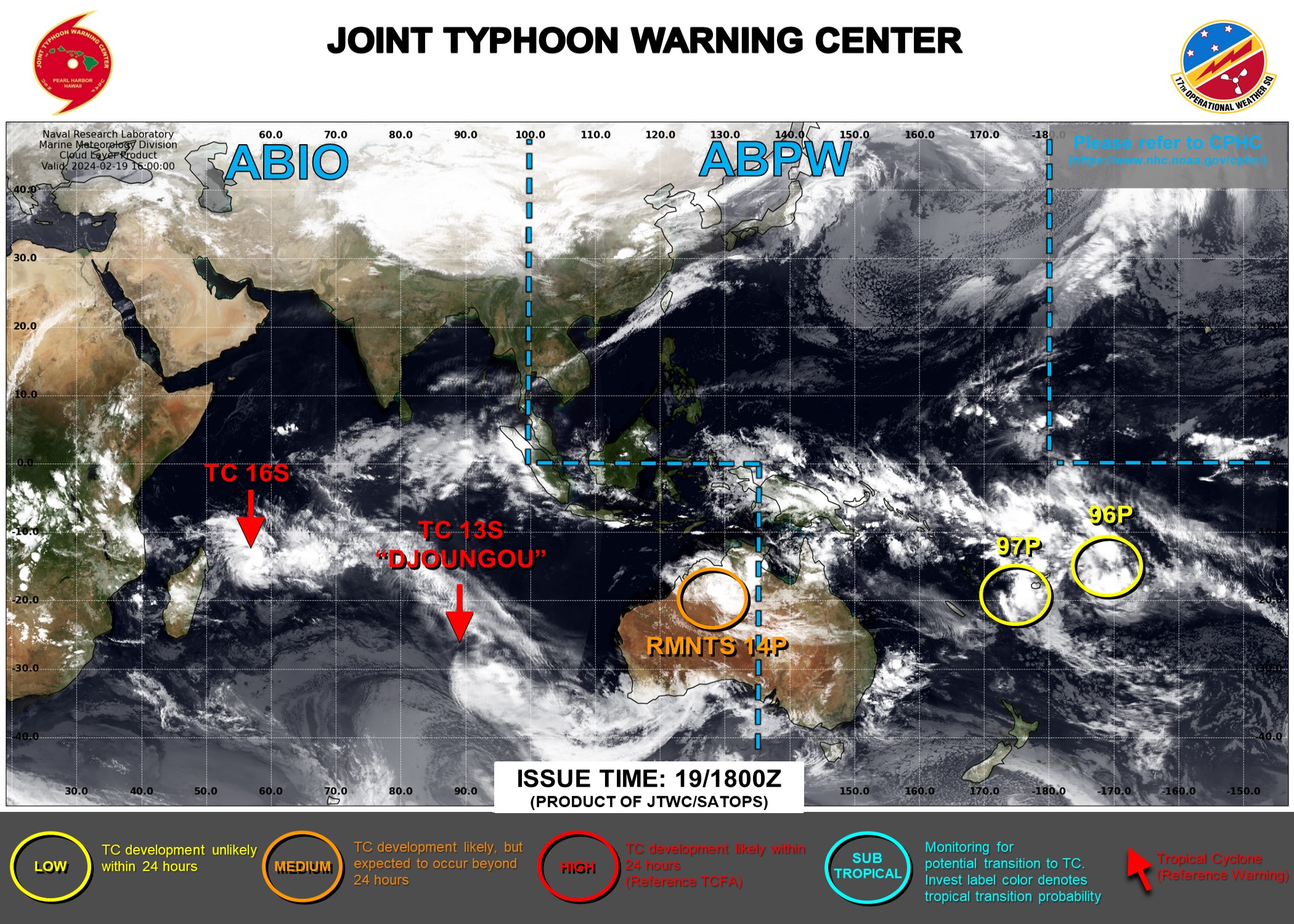
1. NORTH INDIAN OCEAN AREA (MALAY PENINSULA WEST TO COAST OF AFRICA):
A. TROPICAL CYCLONE SUMMARY: NONE.
B. TROPICAL DISTURBANCE SUMMARY: NONE.
C. SUBTROPICAL SYSTEM SUMMARY: NONE.
2. SOUTH INDIAN OCEAN AREA (135E WEST TO COAST OF AFRICA):
A. TROPICAL CYCLONE SUMMARY:
(1) AT 19FEB24 0600Z, TROPICAL CYCLONE 13S (DJOUNGOU) WAS
LOCATED NEAR 25.2S 85.5E, APPROXIMATELY 1013 NM SOUTHWEST OF COCOS
ISLANDS, AND HAD TRACKED SOUTHEASTWARD AT 28 KNOTS OVER THE PAST SIX
HOURS. MAXIMUM SUSTAINED SURFACE WINDS WERE ESTIMATED AT 90 KNOTS
GUSTING TO 110 KNOTS. SEE REF A (WTXS31 PGTW 190900) FOR FURTHER
DETAILS.
(2) AT 19FEB24 0000Z, TROPICAL CYCLONE 16S (SIXTEEN) WAS
LOCATED NEAR 14.9S 54.6E, APPROXIMATELY 348 NM NORTH-NORTHWEST OF
PORT LOUIS, MAURITIUS, AND HAD TRACKED EAST- NORTHEASTWARD AT 10
KNOTS OVER THE PAST SIX HOURS. MAXIMUM SUSTAINED SURFACE WINDS WERE
ESTIMATED AT 35 KNOTS GUSTING TO 45 KNOTS. SEE REF B (WTXS32 PGTW
190300) FOR FURTHER DETAILS.
(3) NO OTHER TROPICAL CYCLONES.
B. TROPICAL DISTURBANCE SUMMARY:
(1) AN AREA OF CONVECTION (REMNANTS 14P) HAS PERSISTED NEAR
18.8S 128.8E, APPROXIMATELY 378 NM EAST OF BROOME, AUSTRALIA.
ANIMATED ENHANCED INFRARED (EIR) SATELLITE IMAGERY AND A 190951Z
SSMIS 91GHZ PASS DEPICT A WELL-DEFINED LOW-LEVEL CIRCULATION WITH
ORGANIZED CONVECTION AND SHALLOW BANDING. REMNANTS OF 14P ARE
CURRENTLY LOCATED OVER LAND. ENVIRONMENTAL ANALYSIS INDICATES POOR
EQUATORWARD OUTFLOW ALOFT OFFSET BY LOW (5-10KTS) VERTICAL WIND SHEAR
AND GOOD CONVERGENCE AT THE SURFACE. GLOBAL NUMERICAL MODEL GUIDANCE
IS IN GOOD AGREEMENT THAT REMNANTS OF 14P WILL CONTINUE TRACKING
WEST-NORTHWESTWARD WITH POTENTIAL TO FURTHER CONSOLIDATE AS IT NEARS
THE NORTHWEST AUSTRALIAN COASTLINE. MAXIMUM SUSTAINED SURFACE WINDS
ARE ESTIMATED AT 18 TO 22 KNOTS. MINIMUM SEA LEVEL PRESSURE IS
ESTIMATED TO BE NEAR 1005 MB. THE POTENTIAL FOR THE DEVELOPMENT OF A
SIGNIFICANT TROPICAL CYCLONE WITHIN THE NEXT 24 HOURS IS LOW.
(2) NO OTHER SUSPECT AREAS.
C. SUBTROPICAL SYSTEM SUMMARY: NONE.
3. JUSTIFICATION FOR REISSUE: ADDED THE REMNANTS OF 14P AS A LOW IN
PARAGRAPH 2.B.(1).//
NNNN
ABIO10 PGTW 191800
MSGID/GENADMIN/JOINT TYPHOON WRNCEN PEARL HARBOR HI//
SUBJ/SIGNIFICANT TROPICAL WEATHER ADVISORY FOR THE INDIAN
OCEAN/191800Z-201800ZFEB2024//
REF/A/MSG/JOINT TYPHOON WRNCEN PEARL HARBOR HI/190751ZFEB2024//
REF/B/MSG/JOINT TYPHOON WRNCEN PEARL HARBOR HI/191352ZFEB2024//
NARR/REFS A AND B ARE TROPICAL CYCLONE WARNINGS.//
RMKS/
1. NORTH INDIAN OCEAN AREA (MALAY PENINSULA WEST TO COAST OF AFRICA):
   A. TROPICAL CYCLONE SUMMARY: NONE.
   B. TROPICAL DISTURBANCE SUMMARY: NONE.
   C. SUBTROPICAL SYSTEM SUMMARY: NONE.
2. SOUTH INDIAN OCEAN AREA (135E WEST TO COAST OF AFRICA) :
   A. TROPICAL CYCLONE SUMMARY:
      (1) AT 19FEB24 0600Z, TROPICAL CYCLONE 13S (DJOUNGOU) WAS
LOCATED NEAR 25.2S 85.5E, APPROXIMATELY 1013 NM SOUTHWEST OF COCOS
ISLANDS, AND HAD TRACKED SOUTHEASTWARD AT 28 KNOTS OVER THE PAST SIX
HOURS. MAXIMUM SUSTAINED SURFACE WINDS WERE ESTIMATED AT 90 KNOTS
GUSTING TO 110 KNOTS. SEE REF A (WTXS31 PGTW 190900) FOR FURTHER
DETAILS.
      (2) AT 19FEB24 1200Z, TROPICAL CYCLONE 16S (SIXTEEN) WAS LOCATED
NEAR 14.2S 56.1E, APPROXIMATELY 361 NM NORTH OF PORT LOUIS, MAURITIUS,
AND HAD TRACKED EAST- NORTHEASTWARD AT 11 KNOTS OVER THE PAST SIX
HOURS. MAXIMUM SUSTAINED SURFACE WINDS WERE ESTIMATED AT 35 KNOTS
GUSTING TO 45 KNOTS. SEE REF B (WTXS32 PGTW 191500) FOR FURTHER
DETAILS.
      (3) NO OTHER TROPICAL CYCLONES.
   B. TROPICAL DISTURBANCE SUMMARY:
      (1) THE AREA OF CONVECTION (INVEST 14P) PREVIOUSLY LOCATED NEAR
18.8S 128.8E IS NOW LOCATED NEAR 17.9S 127.6E, APPROXIMATELY 372 NM
SOUTH-SOUTHWEST OF DARWIN, AUSTRALIA. ANIMATED ENHANCED INFRARED (EIR)
SATELLITE IMAGERY AND A 190951Z SSMIS 91GHZ PASS DEPICT A WELL-DEFINED
LOW-LEVEL CIRCULATION WITH ORGANIZED CONVECTION AND SHALLOW BANDING.
REMNANTS OF 14P ARE CURRENTLY LOCATED OVER LAND. ENVIRONMENTAL
ANALYSIS INDICATES STRONG POLEWARD OUTFLOW ALOFT AND LOW (5-10KTS)
VERTICAL WIND SHEAR. GLOBAL NUMERICAL MODEL GUIDANCE IS IN GOOD
AGREEMENT THAT REMNANTS OF 14P WILL CONTINUE TRACKING WEST-
NORTHWESTWARD WITH POTENTIAL TO FURTHER CONSOLIDATE AS IT NEARS THE
NORTHWEST AUSTRALIAN COASTLINE. MAXIMUM SUSTAINED SURFACE WINDS ARE
ESTIMATED AT 20 TO 25 KNOTS. MINIMUM SEA LEVEL PRESSURE IS ESTIMATED
TO BE NEAR 999 MB. THE POTENTIAL FOR THE DEVELOPMENT OF A SIGNIFICANT
TROPICAL CYCLONE WITHIN THE NEXT 24 HOURS IS UPGRADED TO MEDIUM.
      (2) NO OTHER SUSPECT AREAS.
   C. SUBTROPICAL SYSTEM SUMMARY: NONE.//
NNNN