最新回复 (61)
-
-

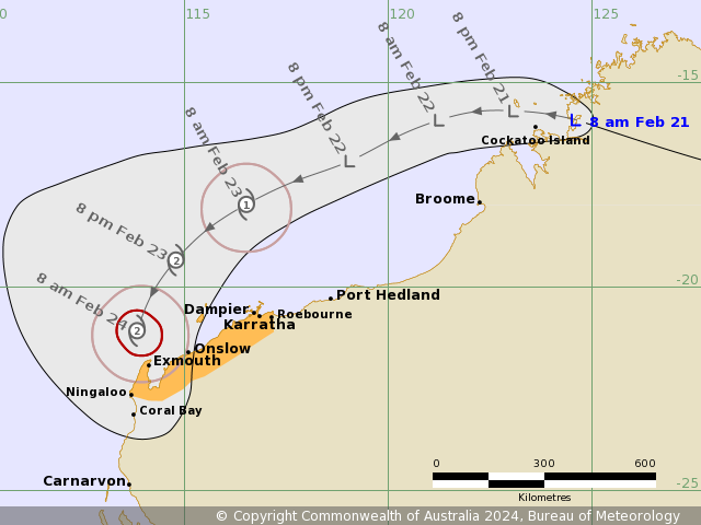
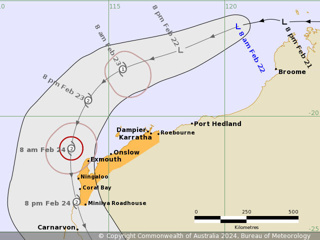
IDW24100

Australian Bureau of Meteorology
Tropical Cyclone Warning Centre

Media: The Standard Emergency Warning Signal should NOT be used with this warning.

PRIORITY
TROPICAL CYCLONE ADVICE NUMBER 1
Issued at 9:07 am WST on Wednesday 21 February 2024

Headline:
Ex-Tropical Cyclone Lincoln to re-develop, possible impacts for the west Pilbara coast Friday and Saturday.

Areas Affected:
Warning Zone
None.

Watch Zone
Roebourne to Ningaloo including Karratha, Dampier, Onslow and Exmouth. .

Cancelled Zone
None.

Details of Ex-Tropical Cyclone Lincoln at 8:00 am AWST:
Intensity: Tropical Low, sustained winds near the centre of 35 kilometres per hour with wind gusts to 85 kilometres per hour.

Location: within 45 kilometres of 15.9 degrees South 124.6 degrees East, estimated to be 105 kilometres east northeast of Cockatoo Island and 980 kilometres east northeast of Karratha.

Movement: west northwest at 15 kilometres per hour.

Ex-Tropical Cyclone Lincoln is moving off the west Kimberley coast this morning. The system will move to the west southwest and slowly develop, likely reaching tropical cyclone intensity during Friday. It will then turn to the southwest towards the west Pilbara coast while developing further. On Saturday the system is most likely to cross the far west Pilbara or upper Gascoyne coast and weaken as it moves inland on Sunday.

Hazards:
GALES with DAMAGING WIND GUSTS of 90 km/h will possible develop early Friday between Roebourne to Karratha.

The risk of GALES with DAMAGING WIND GUSTS of 100 km/h extends west to between Karratha to Ningaloo from Friday evening, and they become more likely during Saturday.

DESTRUCTIVE WIND GUSTS to 140 km/h are also possible near the centre of the system on Saturday.

HEAVY RAINFALL is likely to develop about the western Pilbara as the cyclone approaches the coast from late Friday, and then spread southwards into the western Gascoyne as the system moves inland.

Tides will be higher than normal across the west Pilbara coast on Friday and Saturday.

Recommended Action:
DFES advises of the following community alerts (effective as of 0900 21.02.24)

Blue Alert: People in or near coastal communities Roebourne to Ningaloo including Karratha need to prepare for cyclonic weather and orgainse an emergency kit including first aid kit, torch portable radio, food and water

Next Advice:
The next advice will be issued by 3:00 pm AWST Wednesday 21 February.
Time (AWST) Intensity Latitude/Longitude Estimated Position
Category (decimal deg.) Accuracy (km) 0hr 8 am February 21 tropical low 15.9S 124.6E 45 +6hr 2 pm February 21 tropical low 15.8S 123.9E 75 +12hr 8 pm February 21 tropical low 15.7S 123.1E 100 +18hr 2 am February 22 tropical low 15.7S 122.2E 115 +24hr 8 am February 22 tropical low 15.9S 121.2E 120 +36hr 8 pm February 22 tropical low 16.9S 119.1E 125 +48hr 8 am February 23 1 18.0S 116.5E 165 +60hr 8 pm February 23 2 19.3S 114.8E 215 +72hr 8 am February 24 2 21.1S 113.8E 250 -
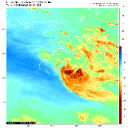
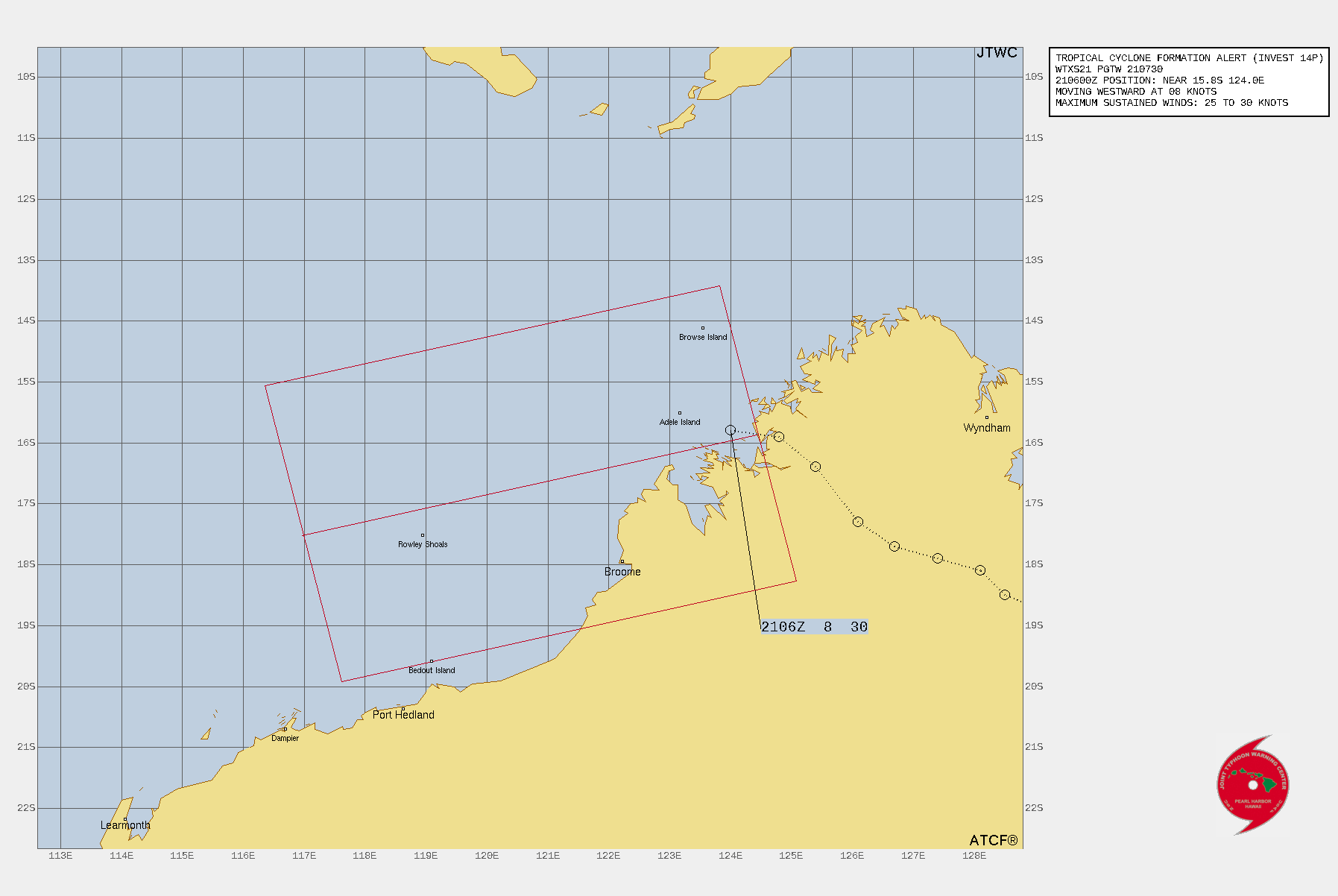
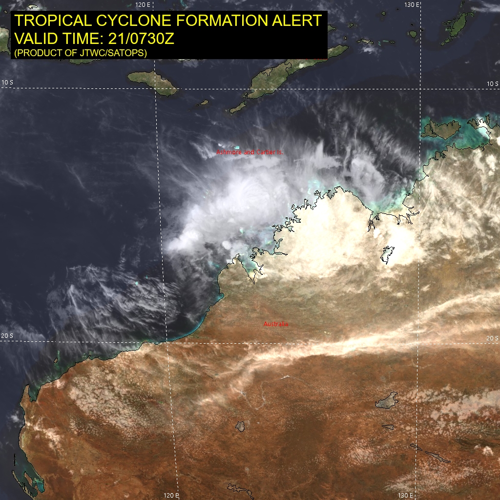
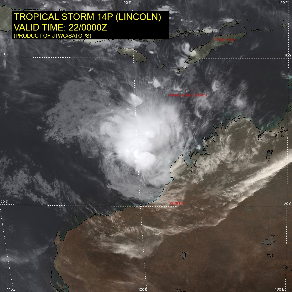
WTXS21 PGTW 210730
MSGID/GENADMIN/JOINT TYPHOON WRNCEN PEARL HARBOR HI//
SUBJ/TROPICAL CYCLONE FORMATION ALERT (INVEST 14P)//
RMKS/
1. FORMATION OF A SIGNIFICANT TROPICAL CYCLONE IS POSSIBLE WITHIN 150 NM
EITHER SIDE OF A LINE FROM 15.9S 124.4E TO 17.5S 117.0E WITHIN THE NEXT
12 TO 24 HOURS. AVAILABLE DATA DOES NOT JUSTIFY ISSUANCE OF NUMBERED
TROPICAL CYCLONE WARNINGS AT THIS TIME. WINDS IN THE AREA ARE ESTIMATED
TO BE 25 TO 30 KNOTS. METSAT IMAGERY, SYNOPTIC DATA AND RADAR DATA AT
210700Z INDICATE THAT A CIRCULATION CENTER IS LOCATED NEAR 15.8S 124.0E.
THE SYSTEM IS MOVING WESTWARD AT 08 KNOTS.
2. REMARKS: THE AREA OF CONVECTION (INVEST 14P) PREVIOUSLY LOCATED NEAR
16.4S 125.2E IS NOW LOCATED NEAR 15.8S 124.0E, APPROXIMATELY 166 NM
NORTHEAST OF BROOME, AUSTRALIA. ANIMATED MULTISPECTRAL SATELLITE IMAGERY
AND ANIMATED RADAR IMAGERY FROM THE BROOME RADAR DEPICT A PARTIALLY-
EXPOSED LOW-LEVEL CIRCULATION WITH FORMATIVE CONVECTIVE BANDING AND LOW-
LEVEL CLOUD LINES WRAPPING INTO A DEFINED CENTER. A 210557Z ATMS 183 GHZ
MICROWAVE IMAGE SHOWS DEEP CONVECTIVE BANDING OVER THE NORTHERN
PERIPHERY WRAPPING INTO THE EASTERN QUADRANT. SURFACE OBSERVATIONS FROM
KOOLAN ISLAND (YKLC, ELEVATION 530 FT), APPROXIMATELY 21 NM SOUTHWEST OF
THE CENTER, INDICATE EASTERLY WINDS SUSTAINED (10-MINUTE AVERAGE) AT 14-
16 KNOTS GUSTING TO 25-30 KNOTS. ENVIRONMENTAL CONDITIONS ARE FAVORABLE
WITH GOOD EQUATORWARD OUTFLOW, MODERATE TO HIGH VERTICAL WIND SHEAR AND
WARM SST VALUES (29-30 C). GLOBAL MODELS (GFS AND ECMWF) INDICATE A
GENERALLY WEST-SOUTHWESTWARD TRACK WITH GRADUAL DEVELOPMENT OVER THE
NEXT 36 TO 48 HOURS AS THE SYSTEM TRACKS AWAY FROM LAND. MAXIMUM
SUSTAINED SURFACE WINDS ARE ESTIMATED AT 25 TO 30 KNOTS. MINIMUM SEA
LEVEL PRESSURE IS ESTIMATED TO BE NEAR 999 MB. THE POTENTIAL FOR THE
DEVELOPMENT OF A SIGNIFICANT TROPICAL CYCLONE WITHIN THE NEXT 24 HOURS
IS HIGH.
3. THIS ALERT WILL BE REISSUED, UPGRADED TO WARNING OR CANCELLED BY
220730Z.//
NNNN
ABIO10 PGTW 210800
MSGID/GENADMIN/JOINT TYPHOON WRNCEN PEARL HARBOR HI//
SUBJ/SIGNIFICANT TROPICAL WEATHER ADVISORY FOR THE INDIAN OCEAN
REISSUED/210800Z-211800ZFEB2024//
REF/A/MSG/JOINT TYPHOON WRNCEN PEARL HARBOR HI/210151ZFEB2024//
REF/B/MSG/JOINT TYPHOON WRNCEN PEARL HARBOR HI/210721ZFEB2024//
NARR/REF A IS A TROPICAL CYCLONE WARNING. REF B IS A TROPICAL CYCLONE
FORMATION ALERT.//
RMKS/
1. NORTH INDIAN OCEAN AREA (MALAY PENINSULA WEST TO COAST OF AFRICA):
   A. TROPICAL CYCLONE SUMMARY: NONE.
   B. TROPICAL DISTURBANCE SUMMARY: NONE.
   C. SUBTROPICAL SYSTEM SUMMARY: NONE.
2. SOUTH INDIAN OCEAN AREA (135E WEST TO COAST OF AFRICA):
   A. TROPICAL CYCLONE SUMMARY:
      (1) AT 21FEB24 0000Z, TROPICAL CYCLONE 16S (ELEANOR) WAS LOCATED
NEAR 14.8S 60.6E, APPROXIMATELY 370 NM NORTH-NORTHEAST OF PORT LOUIS,
MAURITIUS, AND HAD TRACKED SOUTH-SOUTHEASTWARD AT 07 KNOTS OVER THE
PAST SIX HOURS. MAXIMUM SUSTAINED SURFACE WINDS WERE ESTIMATED AT 45
KNOTS GUSTING TO 55 KNOTS. SEE REF A (WTXS32 PGTW 210300) FOR FURTHER
DETAILS.
      (2) NO OTHER TROPICAL CYCLONES.
   B. TROPICAL DISTURBANCE SUMMARY:
      (1) THE AREA OF CONVECTION (INVEST 14P) PREVIOUSLY LOCATED NEAR
16.4S 125.2E IS NOW LOCATED NEAR 15.8S 124.0E, APPROXIMATELY 166 NM
NORTHEAST OF BROOME, AUSTRALIA. ANIMATED MULTISPECTRAL SATELLITE
IMAGERY AND ANIMATED RADAR IMAGERY FROM THE BROOME RADAR DEPICT A
PARTIALLY-EXPOSED LOW-LEVEL CIRCULATION WITH FORMATIVE CONVECTIVE
BANDING AND LOW-LEVEL CLOUD LINES WRAPPING INTO A DEFINED CENTER. A
210557Z ATMS 183 GHZ MICROWAVE IMAGE SHOWS DEEP CONVECTIVE BANDING
OVER THE NORTHERN PERIPHERY WRAPPING INTO THE EASTERN QUADRANT.
SURFACE OBSERVATIONS FROM KOOLAN ISLAND (YKLC, ELEVATION 530 FT),
APPROXIMATELY 21 NM SOUTHWEST OF THE CENTER, INDICATE EASTERLY WINDS
SUSTAINED (10-MINUTE AVERAGE) AT 14-16 KNOTS GUSTING TO 25-30 KNOTS.
ENVIRONMENTAL CONDITIONS ARE FAVORABLE WITH GOOD EQUATORWARD OUTFLOW,
MODERATE TO HIGH VERTICAL WIND SHEAR AND WARM SST VALUES (29-30 C).
GLOBAL MODELS (GFS AND ECMWF) INDICATE A GENERALLY WEST-SOUTHWESTWARD
TRACK WITH GRADUAL DEVELOPMENT OVER THE NEXT 36 TO 48 HOURS AS THE
SYSTEM TRACKS AWAY FROM LAND. MAXIMUM SUSTAINED SURFACE WINDS ARE
ESTIMATED AT 25 TO 30 KNOTS. MINIMUM SEA LEVEL PRESSURE IS ESTIMATED
TO BE NEAR 999 MB. THE POTENTIAL FOR THE DEVELOPMENT OF A SIGNIFICANT
TROPICAL CYCLONE WITHIN THE NEXT 24 HOURS IS UPGRADED TO HIGH. SEE REF
B (WTXS21 PGTW 210730) FOR FURTHER DETAILS.
      (2) NO OTHER SUSPECT AREAS.
   C. SUBTROPICAL SYSTEM SUMMARY: NONE.
3. JUSTIFICATION FOR REISSUE: UPGRADED AREA IN PARA. 2.B.(1) TO
HIGH.//
NNNN
-
IDW27600
TROPICAL CYCLONE TECHNICAL BULLETIN: AUSTRALIA - WESTERN REGION
Issued by AUSTRALIAN BUREAU OF METEOROLOGY TROPICAL CYCLONE WARNING CENTRE
at: 0722 UTC 21/02/2024
Name: Ex-Tropical Cyclone Lincoln
Identifier: 07U
Data At: 0600 UTC
Latitude: 15.9S
Longitude: 123.7E
Location Accuracy: within 20nm (35 km)
Movement Towards: west (277 deg)
Speed of Movement: 8 knots (15 km/h)
Maximum 10-Minute Wind: 20 knots (35 km/h)
Maximum 3-Second Wind Gust: 45 knots (85 km/h)
Central Pressure: 1000 hPa
Radius of 34-knot winds NE quadrant:
Radius of 34-knot winds SE quadrant:
Radius of 34-knot winds SW quadrant:
Radius of 34-knot winds NW quadrant:
Radius of 48-knot winds NE quadrant:
Radius of 48-knot winds SE quadrant:
Radius of 48-knot winds SW quadrant:
Radius of 48-knot winds NW quadrant:
Radius of 64-knot winds:  nm ( km)
Radius of Maximum Winds:   nm (  km)
Dvorak Intensity Code: T2.0/2.0 Initial after moving offshore
Pressure of outermost isobar: 1004 hPa
Radius of outermost closed isobar: 120 nm (220 km)
FORECAST DATA
Date/Time    : Location    : Loc. Accuracy: Max Wind   : Central Pressure
(UTC)        : degrees     :      nm  (km): knots(km/h): hPa
+06:  21/1200: 16.0S 122.8E:     040 (070):  025  (045): 1002
+12:  21/1800: 15.9S 121.7E:     050 (090):  025  (045): 1002
+18:  22/0000: 16.1S 120.6E:     055 (105):  030  (055): 1000
+24:  22/0600: 16.5S 119.6E:     065 (115):  035  (065):  997
+36:  22/1800: 17.6S 117.2E:     070 (130):  040  (075):  995
+48:  23/0600: 18.9S 114.7E:     100 (190):  045  (085):  991
+60:  23/1800: 21.2S 113.6E:     120 (225):  055  (100):  982
+72:  24/0600: 23.5S 113.2E:     150 (280):  055  (100):  981
+96:  25/0600: 28.5S 115.1E:     190 (355):  030  (055):  998
+120: 26/0600:             :              :            :
REMARKS:
Ex-Tropical Cyclone Lincoln has moved offshore of the west Kimberley coast and
is expected to redevelop to tropical cyclone intensity.

Good confidence in the position using visible satellite imagery and nearby
surface observations. Deep convection has continued and developed further to
the north since 07U moved off the coast earlier this morning. CIMSS upper wind
and shear analysis suggests some easterly shear just to the south of the system
where a mid-level ridge is strengthening. However, upper level winds are
generally lighter winds directly over 07U and weak divergent flow.

Dvorak curved band pattern with a wrap of 0.3 gives DT 2.0. Has previously been
over land so no MET/PT. FT is based on DT. FT/CI=2.0. Objective aids are
unavailable at this stage. Intensity is set to 20 knots (10-min mean), largely
based on surface observations (Adele Is and Cockatoo Is) in the vicinity.

SST are around 30 deg C along the initial track. As 07U curves towards the west
Pilbara coast SSTs decrease, but expected to remain above 28C until it reaches
the upper Gascoyne coast region.
A mid-level ridge to the south is moving 07U to the west. As the ridge moves
east, 07U is forecast to curve to the southwest and then south under the
influence of the western side of the ridge. 07U is expected to continue to
intensify with generally low shear and no significant dry air inhibiting, and
as it is smaller than average in size it may develop faster than the standard
rate.
During Friday an upper trough approaches from the west and initially may
improve poleward outflow and development. From Saturday this upper trough moves
closer and assists with moving 07U over land, most likely on Saturday and then
what remains of 07U is taken quickly to the southeast.
The forecast is biased towards model guidance that suggests a more well
developed system currently. There is still a spread in guidance with some
indicating a weaker system that is able to move further west and with some
shear limiting intensification.
There is potential for 07U to intensify to a severe tropical cyclone before the
environment and land interactions begin to limit development.

Copyright Commonwealth of Australia
==
The next bulletin for this system will be issued by: 21/1330 UTC.
Time (AWST) Intensity Category Latitude
(decimal deg.)Longitude
(decimal deg.)Estimated Position
Accuracy (km)0hr 2 pm February 21 tropical low 15.9S 123.7E 35 +6hr 8 pm February 21 tropical low 16.0S 122.8E 70 +12hr 2 am February 22 tropical low 15.9S 121.7E 90 +18hr 8 am February 22 tropical low 16.1S 120.6E 105 +24hr 2 pm February 22 tropical low 16.5S 119.6E 115 +36hr 2 am February 23 1 17.6S 117.2E 130 +48hr 2 pm February 23 1 18.9S 114.7E 190 +60hr 2 am February 24 2 21.2S 113.6E 225 +72hr 2 pm February 24 2 23.5S 113.2E 280 -
IDW27600
TROPICAL CYCLONE TECHNICAL BULLETIN: AUSTRALIA - WESTERN REGION
Issued by AUSTRALIAN BUREAU OF METEOROLOGY TROPICAL CYCLONE WARNING CENTRE
at: 1307 UTC 21/02/2024
Name: Ex-Tropical Cyclone Lincoln
Identifier: 07U
Data At: 1200 UTC
Latitude: 15.9S
Longitude: 122.6E
Location Accuracy: within 20nm (35 km)
Movement Towards: west (270 deg)
Speed of Movement: 10 knots (18 km/h)
Maximum 10-Minute Wind: 20 knots (35 km/h)
Maximum 3-Second Wind Gust: 45 knots (85 km/h)
Central Pressure: 999 hPa
Radius of 34-knot winds NE quadrant:
Radius of 34-knot winds SE quadrant:
Radius of 34-knot winds SW quadrant:
Radius of 34-knot winds NW quadrant:
Radius of 48-knot winds NE quadrant:
Radius of 48-knot winds SE quadrant:
Radius of 48-knot winds SW quadrant:
Radius of 48-knot winds NW quadrant:
Radius of 64-knot winds:  nm ( km)
Radius of Maximum Winds:   nm (  km)
Dvorak Intensity Code: T2.0/2.0 Initial after moving offshore
Pressure of outermost isobar: 1004 hPa
Radius of outermost closed isobar: 220 nm (405 km)
FORECAST DATA
Date/Time    : Location    : Loc. Accuracy: Max Wind   : Central Pressure
(UTC)        : degrees     :      nm  (km): knots(km/h): hPa
+06:  21/1800: 15.9S 121.5E:     035 (065):  025  (045):  999
+12:  22/0000: 16.1S 120.4E:     045 (085):  030  (055):  998
+18:  22/0600: 16.6S 119.4E:     055 (100):  035  (065):  997
+24:  22/1200: 17.1S 118.2E:     065 (115):  035  (065):  997
+36:  23/0000: 18.1S 115.7E:     075 (140):  040  (075):  995
+48:  23/1200: 19.5S 114.0E:     100 (180):  050  (095):  986
+60:  24/0000: 21.5S 113.2E:     110 (210):  055  (100):  982
+72:  24/1200: 24.0S 113.5E:     120 (225):  055  (100):  981
+96:  25/1200: 27.8S 116.7E:     190 (355):  025  (045):  999
+120: 26/1200:             :              :            :
REMARKS:
Ex-Tropical Cyclone Lincoln has moved offshore of the west Kimberley coast and
is expected to redevelop to tropical cyclone intensity.

Moderate confidence in the position using IR satellite imagery and nearby
surface observations with deep convection obscuring the LLCC. CIMSS upper wind
and shear analysis suggests some easterly shear just to the south of the system
where a mid-level ridge is strengthening. However, upper level winds are
generally lighter directly over 07U with good upper divergence.

Dvorak curved band pattern with a wrap of 0.2-0.25 gives DT 1.5. Has previously
been over land so no MET/PT. FT and CI held at 2.0 based on not lowering
overnight within first 48 hours. Objective aids are unavailable at this stage.
Intensity is set to 20 knots (10-min mean), largely based on surface
observations (Adele Is and Koolan Is) in the vicinity.

SST are around 30 deg C along the initial track. As 07U curves towards the west
Pilbara coast SST decrease, but expected to remain above 28C until it reaches
the upper Gascoyne coast region.

A mid-level ridge to the south is moving 07U to the west. As the ridge moves
east, 07U is forecast to curve to the southwest and then south under the
influence of the western side of the ridge. 07U is expected to continue to
intensify with generally low shear and no significant dry air inhibiting, and
as it is smaller than average in size it may develop faster than the standard
rate.

During Friday an upper trough approaches from the west and initially may
improve poleward outflow and development. From Saturday this upper trough moves
closer and assists with moving 07U over land, most likely on Saturday and then
what remains of 07U is taken quickly to the southeast.

There is still a spread in guidance with some indicating a weaker system that
is able to move further west and with some shear limiting intensification.

There is potential for 07U to intensify to a severe tropical cyclone before the
environment and land interactions begin to limit development.

Copyright Commonwealth of Australia
==
The next bulletin for this system will be issued by: 21/1930 UTC.
Time (AWST) Intensity Category Latitude
(decimal deg.)Longitude
(decimal deg.)Estimated Position
Accuracy (km)0hr 8 pm February 21 tropical low 15.9S 122.6E 35 +6hr 2 am February 22 tropical low 15.9S 121.5E 65 +12hr 8 am February 22 tropical low 16.1S 120.4E 85 +18hr 2 pm February 22 tropical low 16.6S 119.4E 100 +24hr 8 pm February 22 tropical low 17.1S 118.2E 115 +36hr 8 am February 23 1 18.1S 115.7E 140 +48hr 8 pm February 23 2 19.5S 114.0E 180 +60hr 8 am February 24 2 21.5S 113.2E 210 +72hr 8 pm February 24 2 24.0S 113.5E 225 -
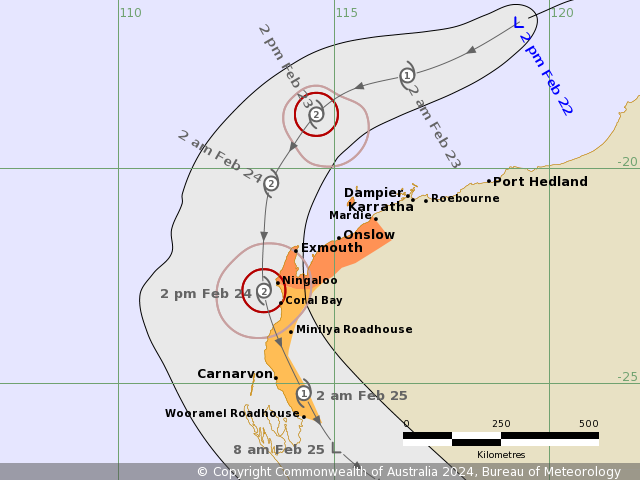
IDW27600
TROPICAL CYCLONE TECHNICAL BULLETIN: AUSTRALIA - WESTERN REGION
Issued by AUSTRALIAN BUREAU OF METEOROLOGY TROPICAL CYCLONE WARNING CENTRE
at: 1836 UTC 21/02/2024
Name: Ex-Tropical Cyclone Lincoln
Identifier: 07U
Data At: 1800 UTC
Latitude: 15.8S
Longitude: 121.5E
Location Accuracy: within 25nm (45 km)
Movement Towards: west (273 deg)
Speed of Movement: 11 knots (20 km/h)
Maximum 10-Minute Wind: 25 knots (45 km/h)
Maximum 3-Second Wind Gust: 45 knots (85 km/h)
Central Pressure: 999 hPa
Radius of 34-knot winds NE quadrant:
Radius of 34-knot winds SE quadrant:
Radius of 34-knot winds SW quadrant:
Radius of 34-knot winds NW quadrant:
Radius of 48-knot winds NE quadrant:
Radius of 48-knot winds SE quadrant:
Radius of 48-knot winds SW quadrant:
Radius of 48-knot winds NW quadrant:
Radius of 64-knot winds:  nm ( km)
Radius of Maximum Winds:   nm (  km)
Dvorak Intensity Code: T2.0/2.0/S0.0/12HRS
Pressure of outermost isobar: 1004 hPa
Radius of outermost closed isobar: 120 nm (220 km)
FORECAST DATA
Date/Time    : Location    : Loc. Accuracy: Max Wind   : Central Pressure
(UTC)        : degrees     :      nm  (km): knots(km/h): hPa
+06:  22/0000: 16.0S 120.4E:     040 (070):  030  (055):  998
+12:  22/0600: 16.4S 119.3E:     050 (095):  035  (065):  997
+18:  22/1200: 17.0S 118.2E:     055 (105):  035  (065):  997
+24:  22/1800: 17.5S 116.8E:     060 (115):  040  (075):  995
+36:  23/0600: 18.6S 114.6E:     070 (130):  045  (085):  991
+48:  23/1800: 20.3S 113.5E:     090 (165):  055  (100):  982
+60:  24/0600: 22.7S 113.2E:     100 (185):  055  (100):  981
+72:  24/1800: 24.9S 114.0E:     120 (220):  035  (065):  994
+96:  25/1800:             :              :            :
+120: 26/1800:             :              :            :
REMARKS:
Ex-Tropical Cyclone Lincoln continues to show persistent bursts of convection
near the estimated LLCC, with some evidence of curvature. Only moderate
confidence in the position using animated IR satellite imagery, Broome weather
radar, and nearby surface observations. Earlier 13UTC-14UTC ASCAT passes
suggest the centre is still somewhat elongated.

Dvorak analysis is based on a curved band pattern with a wrap of 0.3-0.4,
giving DT 2.0. MET and PT not yet available. FT and CI 2.0. Objective aids are
unavailable at this stage. Intensity is set to 25 knots (10-min mean), based on
nearby surface observations (Adele Is and Koolan Is) and earlier ASCAT pass.

07U has been tracking to the west under the influence of a cradling mid-level
ridge to the south. Motion should become west-southwest today and then more
southwest on Friday around the periphery of this feature. On Saturday, an
approaching upper trough will steer the system more south and ultimately
south-southeast before it crosses the WA coast. Confidence in the track
forecast is good given this robust steering pattern.

CIMSS upper wind analysis shows good upper divergence currently near the
system, however also suggests that the system has been under the influence of
moderate to strong deep layer easterly shear due to an upper anticyclone to the
southwest peaking in strength. There is little evidence of this shear in the
cloud pattern, however, and in any case this anticyclone is forecast to weaken
during the next 12 hours, after which conditions for development should improve
until 07U ultimately encounters stronger shear with the approaching upper
trough on Saturday. Sea surface temperatures along the track are initially
favourable for development around 29 to 30 degrees, but decrease to around 26
degrees off the Gascoyne coast, which will also assist to cap development
potential by Saturday.

Therefore, development at the standard rate is forecast from today, with peak
intensity of 55 knots reached on Saturday. Being a small system, however, 07U
will be sensitive to fluctuations in deep layer wind shear so development is
unlikely to be steady. A period of rapid intensification leading to 07U
becoming a severe tropical cyclone cannot be ruled out.

Copyright Commonwealth of Australia
==
The next bulletin for this system will be issued by: 22/0130 UTC.
Time (AWST) Intensity Category Latitude
(decimal deg.)Longitude
(decimal deg.)Estimated Position
Accuracy (km)0hr 2 am February 22 tropical low 15.8S 121.5E 45 +6hr 8 am February 22 tropical low 16.0S 120.4E 70 +12hr 2 pm February 22 tropical low 16.4S 119.3E 95 +18hr 8 pm February 22 tropical low 17.0S 118.2E 105 +24hr 2 am February 23 1 17.5S 116.8E 115 +36hr 2 pm February 23 1 18.6S 114.6E 130 +48hr 2 am February 24 2 20.3S 113.5E 165 +60hr 2 pm February 24 2 22.7S 113.2E 185 +72hr 2 am February 25 1 24.9S 114.0E 220 -
IDW27600
TROPICAL CYCLONE TECHNICAL BULLETIN: AUSTRALIA - WESTERN REGION
Issued by AUSTRALIAN BUREAU OF METEOROLOGY TROPICAL CYCLONE WARNING CENTRE
at: 0115 UTC 22/02/2024
Name: Ex-Tropical Cyclone Lincoln
Identifier: 07U
Data At: 0000 UTC
Latitude: 16.1S
Longitude: 120.6E
Location Accuracy: within 30nm (55 km)
Movement Towards: west (264 deg)
Speed of Movement: 10 knots (18 km/h)
Maximum 10-Minute Wind: 25 knots (45 km/h)
Maximum 3-Second Wind Gust: 45 knots (85 km/h)
Central Pressure: 1000 hPa
Radius of 34-knot winds NE quadrant:
Radius of 34-knot winds SE quadrant:
Radius of 34-knot winds SW quadrant:
Radius of 34-knot winds NW quadrant:
Radius of 48-knot winds NE quadrant:
Radius of 48-knot winds SE quadrant:
Radius of 48-knot winds SW quadrant:
Radius of 48-knot winds NW quadrant:
Radius of 64-knot winds:  nm ( km)
Radius of Maximum Winds:   nm (  km)
Dvorak Intensity Code: T2.0/2.0/S0.0/12HRS
Pressure of outermost isobar: 1004 hPa
Radius of outermost closed isobar: 80 nm (150 km)
FORECAST DATA
Date/Time    : Location    : Loc. Accuracy: Max Wind   : Central Pressure
(UTC)        : degrees     :      nm  (km): knots(km/h): hPa
+06:  22/0600: 16.6S 119.4E:     045 (080):  030  (055):  998
+12:  22/1200: 17.1S 118.1E:     055 (100):  035  (065):  996
+18:  22/1800: 17.5S 116.8E:     060 (110):  040  (075):  996
+24:  23/0000: 18.0S 115.6E:     065 (125):  045  (085):  993
+36:  23/1200: 19.3S 114.1E:     075 (140):  050  (095):  984
+48:  24/0000: 21.4S 113.4E:     095 (175):  055  (100):  982
+60:  24/1200: 23.7S 113.6E:     115 (210):  050  (095):  984
+72:  25/0000: 25.7S 114.5E:     135 (250):  030  (055):  995
+96:  26/0000:             :              :            :
+120: 27/0000:             :              :            :
REMARKS:
Ex-Tropical Cyclone Lincoln (07U) continues to show persistent convection near
the LLCC, with some curvature. Fair confidence in the position using animated
Vis satellite imagery, and extrapolating from SSMIS microwave pass at 2156 UTC.
Broome weather radar, and nearby surface observations have also assisted.

Dvorak analysis is based on a curved band pattern with a wrap of 0.3-0.4,
giving DT 2.0. MET and PT not yet available. FT and CI 2.0. Objective aids are
unavailable at this stage. Intensity is set to 25 knots (10-min mean), based on
nearby surface observations (Adele Is and Koolan Is) and Dvorak estimate.

07U is beginning to track to the west-southwest under the influence of a
cradling mid-level ridge to the south. Motion should become more southwest on
Friday around the periphery of this feature. On Saturday, an approaching upper
trough will steer the system more south and ultimately south-southeast before
it crosses the WA coast. Confidence in the track forecast is good given this
robust steering pattern.

CIMSS upper wind analysis shows good upper divergence currently near the
system, however also suggests that the system has been under the influence of
moderate to strong deep layer easterly shear due to an upper anticyclone to the
southwest peaking in strength. There is little evidence of this shear in the
cloud pattern, however, and in any case this anticyclone is forecast to weaken
during the next 12 hours, after which conditions for development should improve
until 07U ultimately encounters stronger shear with the approaching upper
trough on Saturday. Sea surface temperatures along the track are initially
favourable for development around 29 to 30 degrees, but decrease to around 26
degrees off the Gascoyne coast, which will also assist to cap development
potential by Saturday.

Therefore, development at the standard rate is forecast from today, with peak
intensity of 55 knots reached on Saturday. Being a small system, however, 07U
will be sensitive to fluctuations in deep layer wind shear so development is
unlikely to be steady. A period of rapid intensification leading to 07U
becoming a severe tropical cyclone cannot be ruled out.

Copyright Commonwealth of Australia
==
The next bulletin for this system will be issued by: 22/0730 UTC.
 最后于 2024-02-23 21:35:00 被ygsj24编辑 ,原因:
 -
WTXS31 PGTW 220300
MSGID/GENADMIN/JOINT TYPHOON WRNCEN PEARL HARBOR HI//
SUBJ/TROPICAL CYCLONE 14P (LINCOLN) WARNING NR 004//
REF/A/MSG/JOINT TYPHOON WRNCEN PEARL HARBOR HI/210721ZFEB2024//
AMPN/REF A IS A TROPICAL CYCLONE FORMATION ALERT.//
RMKS/
1. TROPICAL CYCLONE 14P (LINCOLN) WARNING NR 004
   01 ACTIVE TROPICAL CYCLONE IN SOUTHIO
   MAX SUSTAINED WINDS BASED ON ONE-MINUTE AVERAGE
   WIND RADII VALID OVER OPEN WATER ONLY
    ---
   WARNING POSITION:
   220000Z --- NEAR 16.4S 120.8E
     MOVEMENT PAST SIX HOURS - 230 DEGREES AT 11 KTS
     POSITION ACCURATE TO WITHIN 050 NM
     POSITION BASED ON CENTER LOCATED BY SATELLITE
   PRESENT WIND DISTRIBUTION:
   MAX SUSTAINED WINDS - 030 KT, GUSTS 040 KT
   WIND RADII VALID OVER OPEN WATER ONLY
   REPEAT POSIT: 16.4S 120.8E
    ---
   FORECASTS:
   12 HRS, VALID AT:
   221200Z --- 17.3S 118.4E
   MAX SUSTAINED WINDS - 035 KT, GUSTS 045 KT
   WIND RADII VALID OVER OPEN WATER ONLY
   RADIUS OF 034 KT WINDS - 000 NM NORTHEAST QUADRANT
                            060 NM SOUTHEAST QUADRANT
                            060 NM SOUTHWEST QUADRANT
                            000 NM NORTHWEST QUADRANT
   VECTOR TO 24 HR POSIT: 250 DEG/ 12 KTS
    ---
   24 HRS, VALID AT:
   230000Z --- 18.1S 116.1E
   MAX SUSTAINED WINDS - 040 KT, GUSTS 050 KT
   WIND RADII VALID OVER OPEN WATER ONLY
   RADIUS OF 034 KT WINDS - 050 NM NORTHEAST QUADRANT
                            070 NM SOUTHEAST QUADRANT
                            070 NM SOUTHWEST QUADRANT
                            000 NM NORTHWEST QUADRANT
   VECTOR TO 36 HR POSIT: 225 DEG/ 10 KTS
    ---
   36 HRS, VALID AT:
   231200Z --- 19.4S 114.6E
   MAX SUSTAINED WINDS - 045 KT, GUSTS 055 KT
   WIND RADII VALID OVER OPEN WATER ONLY
   RADIUS OF 034 KT WINDS - 080 NM NORTHEAST QUADRANT
                            090 NM SOUTHEAST QUADRANT
                            080 NM SOUTHWEST QUADRANT
                            050 NM NORTHWEST QUADRANT
   VECTOR TO 48 HR POSIT: 205 DEG/ 11 KTS
    ---
   EXTENDED OUTLOOK:
   48 HRS, VALID AT:
   240000Z --- 21.4S 113.7E
   MAX SUSTAINED WINDS - 050 KT, GUSTS 065 KT
   WIND RADII VALID OVER OPEN WATER ONLY
   RADIUS OF 050 KT WINDS - 030 NM NORTHEAST QUADRANT
                            030 NM SOUTHEAST QUADRANT
                            000 NM SOUTHWEST QUADRANT
                            000 NM NORTHWEST QUADRANT
   RADIUS OF 034 KT WINDS - 100 NM NORTHEAST QUADRANT
                            100 NM SOUTHEAST QUADRANT
                            080 NM SOUTHWEST QUADRANT
                            060 NM NORTHWEST QUADRANT
   VECTOR TO 72 HR POSIT: 170 DEG/ 09 KTS
    ---
   72 HRS, VALID AT:
   250000Z --- 24.8S 114.3E
   MAX SUSTAINED WINDS - 035 KT, GUSTS 045 KT
   WIND RADII VALID OVER OPEN WATER ONLY
   DISSIPATING AS A SIGNIFICANT TROPICAL CYCLONE OVER LAND
   RADIUS OF 034 KT WINDS - 080 NM NORTHEAST QUADRANT
                            070 NM SOUTHEAST QUADRANT
                            000 NM SOUTHWEST QUADRANT
                            000 NM NORTHWEST QUADRANT
   VECTOR TO 96 HR POSIT: 145 DEG/ 11 KTS
    ---
   LONG RANGE OUTLOOK:
    ---
   96 HRS, VALID AT:
   260000Z --- 28.3S 117.3E
   MAX SUSTAINED WINDS - 025 KT, GUSTS 035 KT
   WIND RADII VALID OVER OPEN WATER ONLY
   DISSIPATED AS A SIGNIFICANT TROPICAL CYCLONE OVER LAND
    ---
REMARKS:
220300Z POSITION NEAR 16.6S 120.2E.
22FEB24. TROPICAL CYCLONE 14P (LINCOLN), LOCATED APPROXIMATELY
519 NM NORTHEAST OF LEARMONTH, AUSTRALIA, HAS TRACKED
SOUTHWESTWARD AT 11 KNOTS OVER THE PAST SIX HOURS. AVAILABLE
METEOROLOGICAL DATA SUPPORTS THE REGNERATION OF TD 14P,
THEREFORE, JTWC HAS RESUMED WARNINGS. MINIMUM CENTRAL PRESSURE
AT 220000Z IS 997 MB. MAXIMUM SIGNIFICANT WAVE HEIGHT AT 220000Z
IS 12 FEET. NEXT WARNINGS AT 220900Z, 221500Z, 222100Z AND 230300Z.
REFER TO TROPICAL CYCLONE 16S (ELEANOR) WARNINGS (WTXS32 PGTW) FOR
TWELVE-HOURLY UPDATES.
2. THIS CANCELS AND SUPERSEDES REF A (WTXS21 PGTW 210730).//
NNNN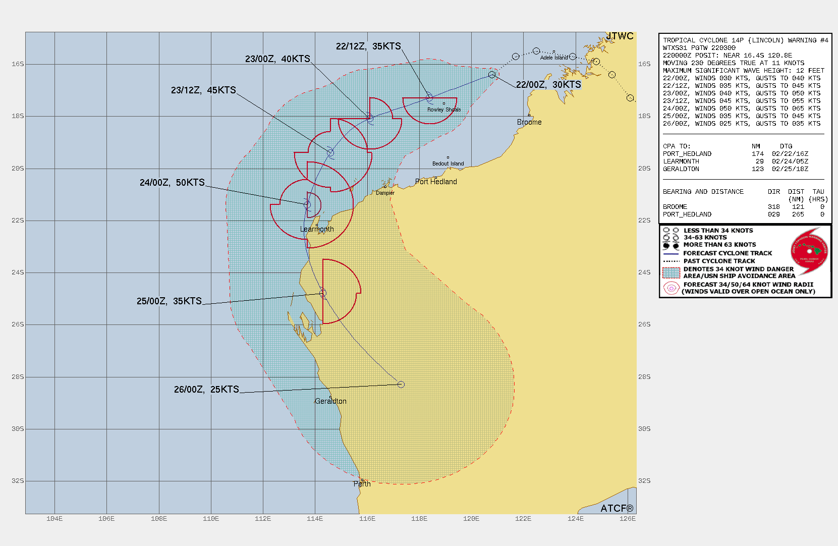
-
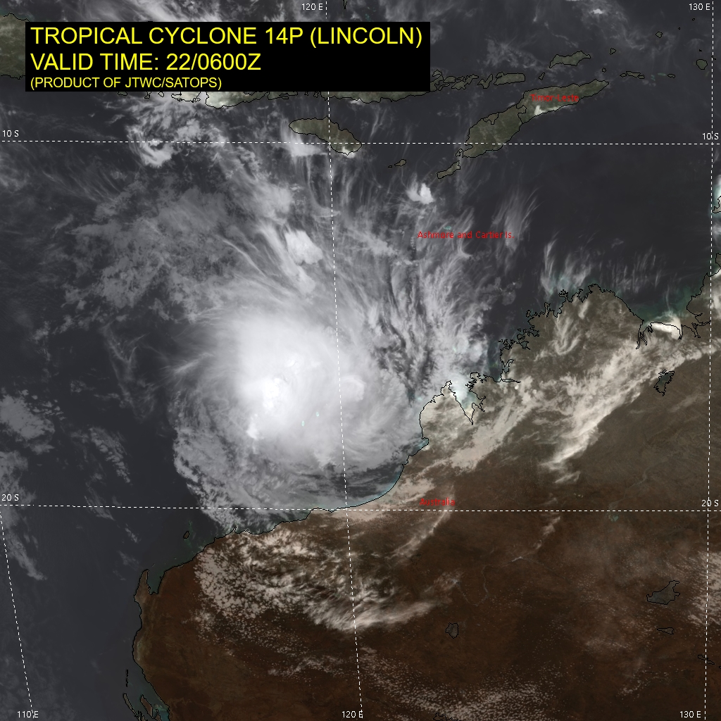
IDW27600
TROPICAL CYCLONE TECHNICAL BULLETIN: AUSTRALIA - WESTERN REGION
Issued by AUSTRALIAN BUREAU OF METEOROLOGY TROPICAL CYCLONE WARNING CENTRE
at: 0711 UTC 22/02/2024
Name: Ex-Tropical Cyclone Lincoln
Identifier: 07U
Data At: 0600 UTC
Latitude: 16.6S
Longitude: 119.3E
Location Accuracy: within 25nm (45 km)
Movement Towards: west southwest (252 deg)
Speed of Movement: 11 knots (21 km/h)
Maximum 10-Minute Wind: 30 knots (55 km/h)
Maximum 3-Second Wind Gust: 45 knots (85 km/h)
Central Pressure: 1000 hPa
Radius of 34-knot winds NE quadrant:
Radius of 34-knot winds SE quadrant:
Radius of 34-knot winds SW quadrant:
Radius of 34-knot winds NW quadrant:
Radius of 48-knot winds NE quadrant:
Radius of 48-knot winds SE quadrant:
Radius of 48-knot winds SW quadrant:
Radius of 48-knot winds NW quadrant:
Radius of 64-knot winds:  nm ( km)
Radius of Maximum Winds:   nm (  km)
Dvorak Intensity Code: T2.5/2.5/D0.5/24HRS STT:D0.5/06HRS
Pressure of outermost isobar: 1004 hPa
Radius of outermost closed isobar: 100 nm (185 km)
FORECAST DATA
Date/Time    : Location    : Loc. Accuracy: Max Wind   : Central Pressure
(UTC)        : degrees     :      nm  (km): knots(km/h): hPa
+06:  22/1200: 17.3S 118.1E:     040 (070):  035  (065): 1001
+12:  22/1800: 17.8S 116.7E:     050 (095):  040  (075):  999
+18:  23/0000: 18.2S 115.4E:     060 (105):  045  (085): 1000
+24:  23/0600: 18.7S 114.6E:     065 (120):  050  (095):  997
+36:  23/1800: 20.4S 113.5E:     075 (145):  055  (100):  997
+48:  24/0600: 22.8S 113.4E:     095 (170):  050  (095):  996
+60:  24/1800: 25.2S 114.3E:     115 (210):  040  (075):  997
+72:  25/0600: 27.3S 116.1E:     150 (280):  030  (055):  999
+96:  :             :              :            :
+120: :             :              :            :
REMARKS:
Ex-Tropical Cyclone Lincoln (07U) has had periods of enhanced convection with
fairly well developed curvature around the LLCC and also periods where easterly
shear has been evident and limiting convection, specifically in the most recent
imagery. Fair confidence in the position using animated Vis satellite imagery,
and extrapolating from ASCAT scatterometry at 0144 UTC. 07U has moved away from
Broome weather radar, though nearby surface observation (Rowley Shoals) has
assisted.

Dvorak analysis is based on a shear pattern <0.5 degree from the strong
temperature gradient, giving DT 3.0. There isn't great confidence in our DT and
MET is now available. A D trend yields a MET of 3.0, this is adjusted with PT
of 2.5. FT and CI biased to PT and are both 2.5. Some objective aids have
recently become available: ADT 39 kn; AiDT 30 kn (1-min mean). Intensity set at
30 knots (10-min mean) based on earlier 0144 UTC ASCAT pass and supported by
Dvorak and nearby observation (Rowley Shoals).

07U is continuing to track to the west-southwest under the influence of a
cradling mid-level ridge to the south. Motion should become more southwest on
Friday around the periphery of this feature. On Saturday, an approaching upper
trough will steer the system more south and ultimately south-southeast before
it crosses the WA coast. Confidence in the track forecast is good given this
robust steering pattern. CIMSS upper wind analysis shows good upper divergence
currently near the system, however also suggests that the system has been under
the influence of moderate to strong deep layer easterly shear due to an upper
anticyclone to the south and this is likely slowing current development. This
anticyclone is forecast to weaken during the next 6-12 hours, after which
conditions for development should improve until 07U ultimately encounters
stronger northerly shear with the approaching upper trough on Saturday. Sea
surface temperatures along the track are favourable for development around 29
to 30 degrees, but decrease to around 26 degrees off the Gascoyne coast, which
will also assist to cap development potential by Saturday.

Consequently, slow development for the next 6-12hrs and then near the standard
rate is forecast, with peak intensity of 55 knots reached on Saturday. Being a
small system, however, 07U will be sensitive to fluctuations in deep layer wind
shear so development is likely to fluctuate. A period of rapid intensification
leading to 07U becoming a severe tropical cyclone tonight or Friday morning,
where poleward outflow increases and shear influence may yet to have
significantly increased, cannot be ruled out.

Copyright Commonwealth of Australia
==
The next bulletin for this system will be issued by: 22/1330 UTC.
Time (AWST) Intensity Category Latitude
(decimal deg.)Longitude
(decimal deg.)Estimated Position
Accuracy (km)0hr 2 pm February 22 tropical low 16.6S 119.3E 45 +6hr 8 pm February 22 1 17.3S 118.1E 70 +12hr 2 am February 23 1 17.8S 116.7E 95 +18hr 8 am February 23 1 18.2S 115.4E 105 +24hr 2 pm February 23 2 18.7S 114.6E 120 +36hr 2 am February 24 2 20.4S 113.5E 145 +48hr 2 pm February 24 2 22.8S 113.4E 170 +60hr 2 am February 25 1 25.2S 114.3E 210 +72hr 2 pm February 25 tropical low 27.3S 116.1E 280 -
WTXS31 PGTW 220900
MSGID/GENADMIN/JOINT TYPHOON WRNCEN PEARL HARBOR HI//
SUBJ/TROPICAL CYCLONE 14P (LINCOLN) WARNING NR 005//
RMKS/
1. TROPICAL CYCLONE 14P (LINCOLN) WARNING NR 005
   02 ACTIVE TROPICAL CYCLONES IN SOUTHIO
   MAX SUSTAINED WINDS BASED ON ONE-MINUTE AVERAGE
   WIND RADII VALID OVER OPEN WATER ONLY
    ---
   WARNING POSITION:
   220600Z --- NEAR 16.8S 119.4E
     MOVEMENT PAST SIX HOURS - 235 DEGREES AT 12 KTS
     POSITION ACCURATE TO WITHIN 060 NM
     POSITION BASED ON CENTER LOCATED BY SATELLITE
   PRESENT WIND DISTRIBUTION:
   MAX SUSTAINED WINDS - 035 KT, GUSTS 045 KT
   WIND RADII VALID OVER OPEN WATER ONLY
   RADIUS OF 034 KT WINDS - 040 NM NORTHEAST QUADRANT
                            065 NM SOUTHEAST QUADRANT
                            075 NM SOUTHWEST QUADRANT
                            075 NM NORTHWEST QUADRANT
   REPEAT POSIT: 16.8S 119.4E
    ---
   FORECASTS:
   12 HRS, VALID AT:
   221800Z --- 17.8S 116.8E
   MAX SUSTAINED WINDS - 040 KT, GUSTS 050 KT
   WIND RADII VALID OVER OPEN WATER ONLY
   RADIUS OF 034 KT WINDS - 050 NM NORTHEAST QUADRANT
                            060 NM SOUTHEAST QUADRANT
                            060 NM SOUTHWEST QUADRANT
                            050 NM NORTHWEST QUADRANT
   VECTOR TO 24 HR POSIT: 245 DEG/ 11 KTS
    ---
   24 HRS, VALID AT:
   230600Z --- 18.8S 114.7E
   MAX SUSTAINED WINDS - 045 KT, GUSTS 055 KT
   WIND RADII VALID OVER OPEN WATER ONLY
   RADIUS OF 034 KT WINDS - 060 NM NORTHEAST QUADRANT
                            070 NM SOUTHEAST QUADRANT
                            070 NM SOUTHWEST QUADRANT
                            070 NM NORTHWEST QUADRANT
   VECTOR TO 36 HR POSIT: 210 DEG/ 09 KTS
    ---
   36 HRS, VALID AT:
   231800Z --- 20.4S 113.7E
   MAX SUSTAINED WINDS - 050 KT, GUSTS 065 KT
   WIND RADII VALID OVER OPEN WATER ONLY
   RADIUS OF 050 KT WINDS - 030 NM NORTHEAST QUADRANT
                            030 NM SOUTHEAST QUADRANT
                            000 NM SOUTHWEST QUADRANT
                            000 NM NORTHWEST QUADRANT
   RADIUS OF 034 KT WINDS - 070 NM NORTHEAST QUADRANT
                            080 NM SOUTHEAST QUADRANT
                            070 NM SOUTHWEST QUADRANT
                            070 NM NORTHWEST QUADRANT
   VECTOR TO 48 HR POSIT: 190 DEG/ 10 KTS
    ---
   EXTENDED OUTLOOK:
   48 HRS, VALID AT:
   240600Z --- 22.4S 113.4E
   MAX SUSTAINED WINDS - 050 KT, GUSTS 065 KT
   WIND RADII VALID OVER OPEN WATER ONLY
   RADIUS OF 050 KT WINDS - 030 NM NORTHEAST QUADRANT
                            030 NM SOUTHEAST QUADRANT
                            000 NM SOUTHWEST QUADRANT
                            000 NM NORTHWEST QUADRANT
   RADIUS OF 034 KT WINDS - 070 NM NORTHEAST QUADRANT
                            080 NM SOUTHEAST QUADRANT
                            060 NM SOUTHWEST QUADRANT
                            070 NM NORTHWEST QUADRANT
   VECTOR TO 72 HR POSIT: 160 DEG/ 12 KTS
    ---
   72 HRS, VALID AT:
   250600Z --- 26.8S 115.3E
   MAX SUSTAINED WINDS - 035 KT, GUSTS 045 KT
   WIND RADII VALID OVER OPEN WATER ONLY
   DISSIPATING AS A SIGNIFICANT TROPICAL CYCLONE OVER LAND
   VECTOR TO 96 HR POSIT: 125 DEG/ 14 KTS
    ---
   LONG RANGE OUTLOOK:
    ---
   96 HRS, VALID AT:
   260600Z --- 29.7S 120.6E
   MAX SUSTAINED WINDS - 025 KT, GUSTS 035 KT
   WIND RADII VALID OVER OPEN WATER ONLY
   DISSIPATED AS A SIGNIFICANT TROPICAL CYCLONE OVER LAND
    ---
REMARKS:
220900Z POSITION NEAR 17.1S 118.8E.
22FEB24. TROPICAL CYCLONE 14P (LINCOLN), LOCATED APPROXIMATELY
446 NM NORTHEAST OF LEARMONTH, AUSTRALIA, HAS TRACKED
SOUTHWESTWARD AT 12 KNOTS OVER THE PAST SIX HOURS. MINIMUM CENTRAL
PRESSURE AT 220600Z IS 990 MB. MAXIMUM SIGNIFICANT WAVE HEIGHT AT
220600Z IS 15 FEET. NEXT WARNINGS AT 221500Z, 222100Z, 230300Z AND
230900Z. REFER TO TROPICAL CYCLONE 16S (ELEANOR) WARNINGS (WTXS32
PGTW) FOR TWELVE-HOURLY UPDATES.//
NNNN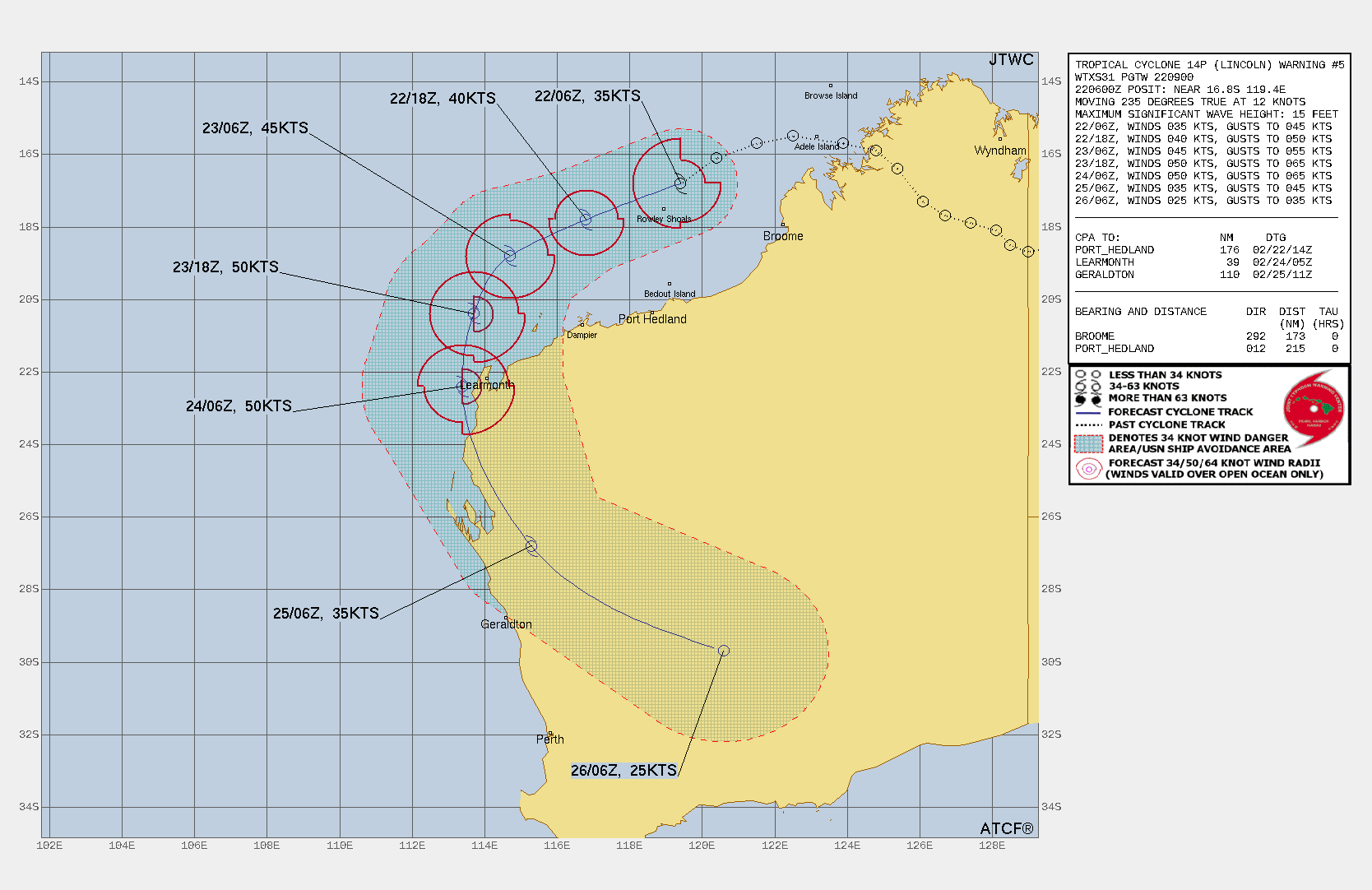
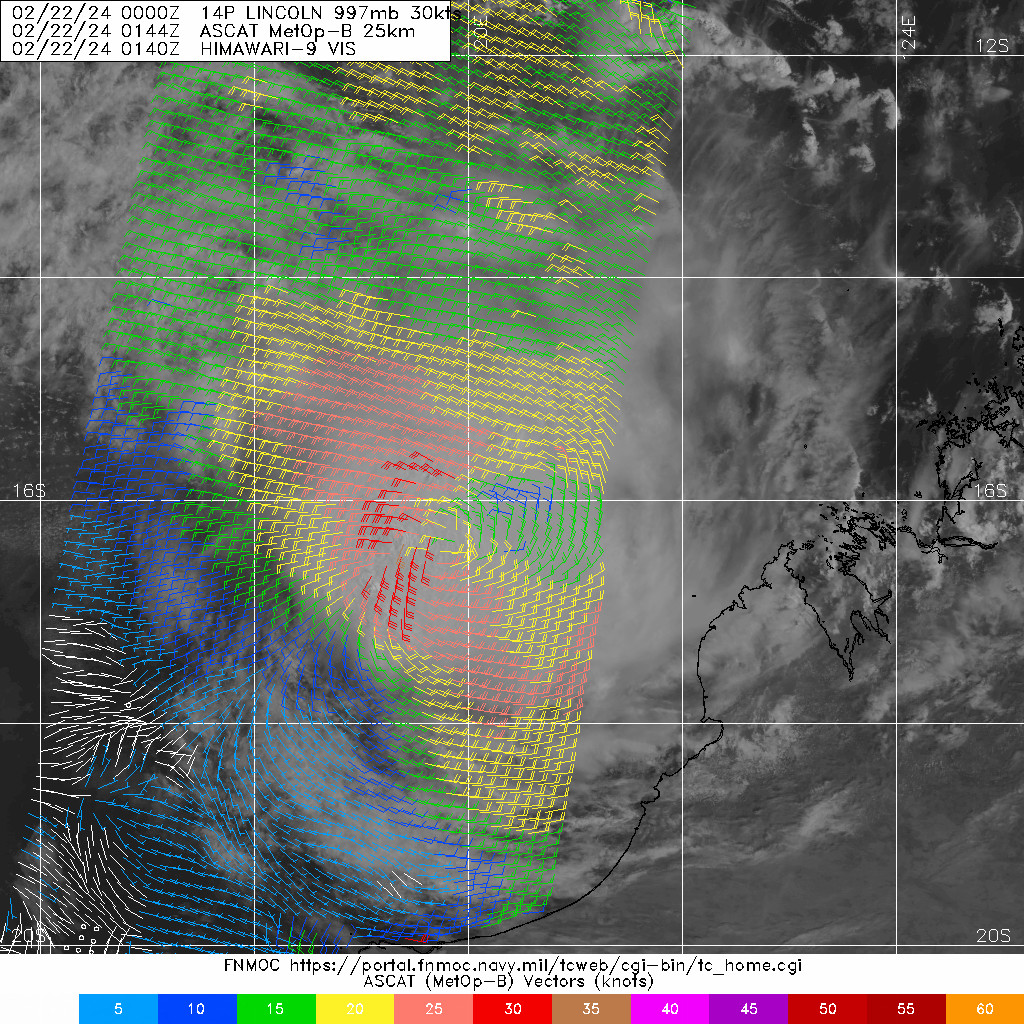
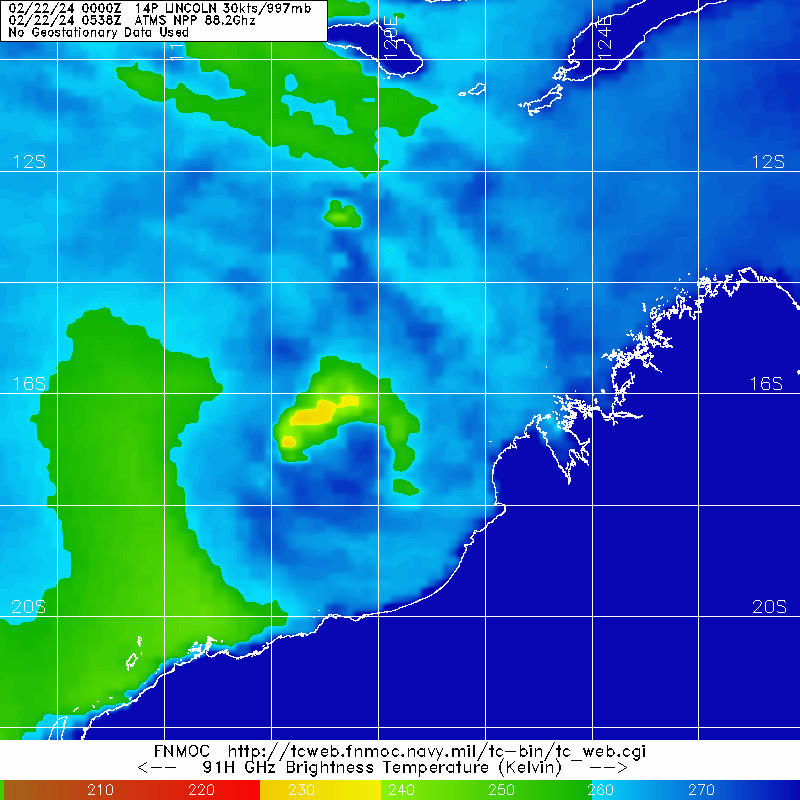
WDXS31 PGTW 220900
MSGID/GENADMIN/JOINT TYPHOON WRNCEN PEARL HARBOR HI//
SUBJ/PROGNOSTIC REASONING FOR TROPICAL CYCLONE 14P (LINCOLN)
WARNING NR 005//
RMKS/
1. FOR METEOROLOGISTS.
2. 6 HOUR SUMMARY AND ANALYSIS.

SUMMARY:
   INITIAL POSITION: 16.8S 119.4E
   INITIAL INTENSITY: 35 KTS
   GEOGRAPHIC REFERENCE: 446 NM NORTHEAST OF LEARMONTH, AUSTRALIA
   MOVEMENT PAST 6 HOURS: SOUTHWESTWARD AT 12 KTS
   SIGNIFICANT WAVE HEIGHT: 15 FEET

SATELLITE ANALYSIS, INITIAL POSITION AND INTENSITY DISCUSSION:
ANIMATED MULTISPECTRAL SATELLITE IMAGERY (MSI) DEPICTS TROPICAL
CYCLONE (TC) 14P (LINCOLN) FURTHER CONSOLIDATING WITH DEEP,
PERSISTENT CENTRAL CONVECTION AND INCREASED CURVED BANDING EVIDENT
IN THE SOUTHERN PERIPHERY OVER THE PAST SIX HOURS. THOUGH THE
ENVIRONMENT IS ASSESSED AS MARGINALLY FAVORABLE WITH WARM (29-30C)
SEA SURFACE TEMPERATURES (SST) AND VERY LOW (0-5 KTS) VERTICAL WIND
SHEAR, WEAK DIVERGENCE AND AN ELONGATED LOW-LEVEL CIRCULATION
CENTER (NORTHEAST TO SOUTHWEST ORIENTATION), OBSERVABLE IN A 20144Z
ASCAT-B SCATTEROMETRY IMAGE, WILL LIKELY KEEP INTENSIFICATION
LIMITED TO A GRADUAL RISE OVER TIME. THE INITIAL POSITION IS PLACED
WITH MEDIUM CONFIDENCE BASED ON AN 220538Z 88.2GHZ ATMS SATELLITE
MICROWAVE IMAGE. THE INITIAL INTENSITY OF 35 KTS IS ASSESSED WITH
MEDIUM CONFIDENCE BASED ON EXTRAPOLATION OF THE AFOREMENTIONED
ASCAT-B IMAGE AND THE INTENSITY ESTIMATES LISTED BELOW.

INITIAL WIND RADII BASIS: SCATTEROMETER DATA

CURRENT STEERING MECHANISM: SUBTROPICAL RIDGE (STR) OVER WESTERN
AUSTRALIA.

AGENCY DVORAK AND AUTOMATED FIXES:
   PGTW: T3.0 - 45 KTS
   KNES: T2.5 - 35 KTS
   APRF: T2.5 - 35 KTS
   CIMSS ADT: 39KTS AT 220600Z
   CIMSS AIDT: 30KTS AT 220600Z

FORECASTER ASSESSMENT OF CURRENT ENVIRONMENT: MARGINALLY FAVORABLE
   VWS: 0-5 KTS
   SST: 29-30 CELSIUS
   OUTFLOW: WEAK EQUATORWARD

ANALYSIS CONFIDENCE:
   INITIAL POSITION: MEDIUM
   INITIAL INTENSITY: MEDIUM
   INITIAL WIND RADII: MEDIUM

3. FORECAST REASONING.

SIGNIFICANT FORECAST CHANGES: THERE ARE NO SIGNIFICANT CHANGES TO
THE FORECAST FROM THE PREVIOUS WARNING.

FORECAST DISCUSSION: TC 14P IS FORECAST TO TRACK WEST-SOUTHWESTWARD
FROM TAU 00 TO TAU 24 AND THEN SOUTHWESTWARD TO SOUTH-SOUTHWESTWARD
TO TAU 48. A MARGINALLY FAVORABLE ENVIRONMENT WILL LIKELY ALLOW FOR
A GRADUAL INTENSIFICATION TO OCCUR TO TAU 48, PEAKING NEAR 50KTS.
LEARMONTH MAY BE IMPACTED BY WINDS AT OR SLIGHTLY HIGHER THAN THE
FORECASTED INTENSITY DUE TO COMPOUNDING THE STORMS TRACK SPEED WITH
ASSESSED INTENSITY (FRONT-LEFT QUADRANT). AT TAU 48, THE EMERGENCE
OF MODERATE (15-20KTS) VWS AND LAND INTERACTION ARE EXPECTED TO
BEGIN WEAKENING THE SYSTEM, COMING TO DISSIPATION OVER LAND PRIOR TO
TAU 96.

MODEL DISCUSSION: GLOBAL NUMERICAL MODELS ARE IN GOOD AGREEMENT
THAT TC 14P WILL CONTINUE ON A WEST-SOUTH-WESTWARD TRACK FROM TAU
00 TO TAU 24 AND THEN TURNING TO A SOUTHWARD TRACK BY TAU 48,
GRADUALLY INCREASING IN INTENSITY OVER THE SAME INTERVAL. A TIGHT
CROSS-TRACK SPREAD OF 44NM IS PRESENT BETWEEN JTWC CONSENSUS MEMBER
AT TAU 48. ALL CONSENSUS MEMBERS SUGGEST A TRACK WEST OF LEARMONTH,
AUSTRALIA, PLACING LEARMONTH IN THE FRONT-LEFT QUADRANT OF THE
SYSTEM NEAR TAU 48.  FROM TAU 48 TO TAU 72, MODELS INDICATE
LANDFALL TO OCCUR NEAR TAU 54 90NM SOUTH-SOUTHWEST OF LEARMONTH AS
THE SYSTEM ROUNDS THE STR AND TURNS TO A SOUTHEASTWARD TRACK.
GUIDANCE INDICATES DISSIPATION OVER LAND WILL OCCUR BETWEEN TAU 72
AND TAU 96.

FORECAST CONFIDENCE:
   TRACK 0 - 72 HR: MEDIUM
   TRACK 72-120 HR: LOW
   INTENSITY 0 - 72 HR: MEDIUM
   INTENSITY 72-120 HR: MEDIUM//
NNNN