ABIO10 PGTW 080600
MSGID/GENADMIN/JOINT TYPHOON WRNCEN PEARL HARBOR HI//
SUBJ/SIGNIFICANT TROPICAL WEATHER ADVISORY FOR THE INDIAN OCEAN
REISSUED/080600Z-081800ZMAR2024//
RMKS/
1. NORTH INDIAN OCEAN AREA (MALAY PENINSULA WEST TO COAST OF AFRICA):
A. TROPICAL CYCLONE SUMMARY: NONE.
B. TROPICAL DISTURBANCE SUMMARY: NONE.
C. SUBTROPICAL SYSTEM SUMMARY: NONE.
2. SOUTH INDIAN OCEAN AREA (135E WEST TO COAST OF AFRICA):
A. TROPICAL CYCLONE SUMMARY: NONE.
B. TROPICAL DISTURBANCE SUMMARY:
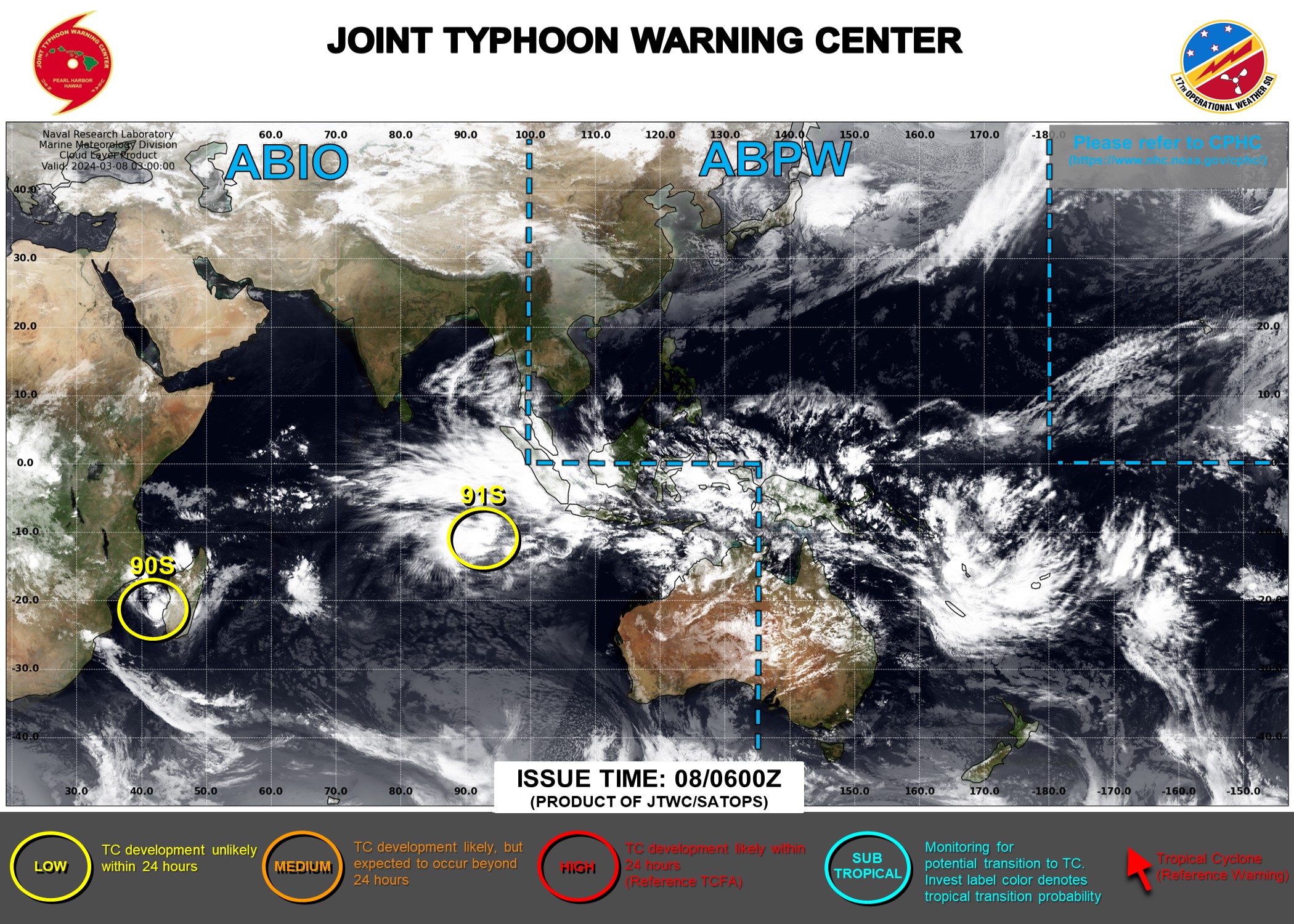
(1) THE AREA OF CONVECTION (INVEST 90S) PREVIOUSLY LOCATED NEAR
22.8S 41.4E IS NOW LOCATED NEAR 23.0S 42.0E, APPROXIMATELY 103 NM
SOUTHEAST OF EUROPA ISLAND. ANIMATED ENHANCED INFRARED SATELLITE
IMAGERY (EIR) AND A 071605Z SSMIS 91GHZ MICROWAVE IMAGE DEPICT A
PARTIALLY EXPOSED LOW-LEVEL CIRCULATION CENTER (LLCC) WITH FLARING
CONVECTION DISPLACED TO THE NORTHEAST OF THE CIRCULATION.
ENVIRONMENTAL ANALYSIS REVEALS A MARGINALLY FAVORABLE ENVIRONMENT FOR
FURTHER DEVELOPMENT WITH LOW (10-15 KTS) VWS, GOOD UPPER-LEVEL
OUTFLOW EQUATORWARD, AND WARM (28-30C) SEA SURFACE TEMPERATURES
(SST). HOWEVER, A DEEP-LAYER DRY AIR MASS WRAPPING INTO 90S FROM THE
WEST IS THE PRIMARY LIMITING FACTOR IN INTENSIFICATION. GLOBAL
DETERMINISTIC MODELS ARE IN GOOD AGREEMENT THAT 90S WILL CONTINUE TO
WEAKEN IN THE MOZAMBIQUE CHANNEL AS IT APPROACHES THE EAST COAST OF
AFRICA OVER THE NEXT 24 HOURS. MAXIMUM SUSTAINED SURFACE WINDS ARE
ESTIMATED AT 18 TO 22 KNOTS. MINIMUM SEA LEVEL PRESSURE IS ESTIMATED
TO BE NEAR 1007 MB. THE POTENTIAL FOR THE DEVELOPMENT OF A
SIGNIFICANT TROPICAL CYCLONE WITHIN THE NEXT 24 HOURS REMAINS LOW.
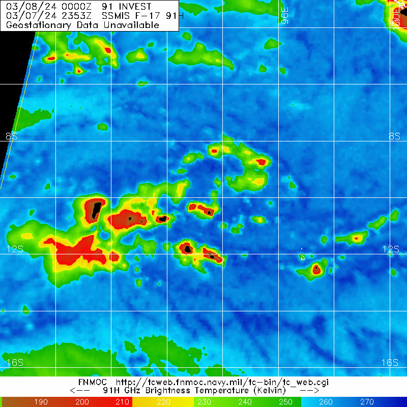
(2) AN AREA OF CONVECTION (INVEST 91S) HAS PERSISTED NEAR 10.5S
93.2E, APPROXIMATELY 238 NM WEST-NORTHWEST OF COCOS ISLAND. ANIMATED
MULTISPECTRAL SATELLITE IMAGERY(MSI) AND A 072353Z SSMIS 91GHZ
MICROWAVE IMAGE DEPICT A BROAD LOW LEVEL CIRCULATION (LLC) WITH
CENTRALIZED FLARING CONVECTION EXTENDING OUTWARDS TO THE NORTHWESTERN
PERIPHERY. ENVIRONMENTAL ANALYSIS REVEALS A MARGINALLY UNFAVORABLE
ENVIRONMENT FOR FURTHER DEVELOPMENT WITH MODERATE TO HIGH (20-25KTS)
VWS, WEAK TO MODERATE UPPER-LEVEL OUTFLOW, OFFSET BY WARM (29-30C)
SEA SURFACE TEMPERATURES (SST). GLOBAL DETERMINISTIC MODELS ARE IN
GOOD AGREEMENT THAT 91S WILL CONTINUE ON AN EASTWARD TRACK INTO A
MORE FAVORABLE ENVIRONMENT WHILE CONSOLIDATING AND STRENGTHENING OVER
THE NEXT 48 HOURS. MAXIMUM SUSTAINED SURFACE WINDS ARE ESTIMATED AT
18 TO 22 KNOTS. MINIMUM SEA LEVEL PRESSURE IS ESTIMATED TO BE NEAR
1005 MB. THE POTENTIAL FOR THE DEVELOPMENT OF A SIGNIFICANT TROPICAL
CYCLONE WITHIN THE NEXT 24 HOURS IS LOW.
(3) NO OTHER SUSPECT AREAS.
C. SUBTROPICAL SYSTEM SUMMARY: NONE.
3. JUSTIFICATION FOR REISSUE: ADDED LOW AREA IN PARA. 2.B.(2).//
NNNN
IDW24000
Australian Bureau of Meteorology
Tropical Cyclone Warning Centre

TROPICAL CYCLONE INFORMATION BULLETIN
Issued at 2:56 pm WST on Saturday 9 March 2024

A Tropical Low was located at 12:30 pm CCT (2:00 pm AWST) near 11.7S 94.8E,
that is 230 km west northwest of Cocos (Keeling) Islands and 1200 km west of
Christmas Island and slow moving.
The low is expected to move to the southeast passing close to Cocos (Keeling)
Islands overnight tonight. Strong monsoonal northwesterly winds are expected
north of the low. The low is not likely to develop into a tropical cyclone this
weekend but has an increasing chance of doing so during the week.

The low will bring an increase in showers and thunderstorms to Cocos Islands,
and then possibly a period of strong winds later Sunday.


The next Information Bulletin will be issued at 8 pm CCT (9 pm AWST).
IDW24000
Australian Bureau of Meteorology
Tropical Cyclone Warning Centre
TROPICAL CYCLONE INFORMATION BULLETIN
Issued at 8:52 pm WST on Saturday 9 March 2024
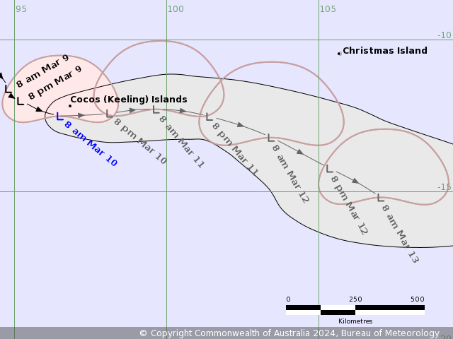
A Tropical Low was located at 6:30 pm CCT (8:00 pm AWST) near 12.1S 95.6E,
that is 135 km west of Cocos (Keeling) Islands and 1120 km west of Christmas
Island and moving east southeast at 9 kilometres per hour.
The low will bring an increase in showers and thunderstorms to Cocos (Keeling)
Islands, and then possibly a period of strong to gale force winds during Sunday.
The next Information Bulletin will be issued at 2 am CCT (3 am AWST).
IDW24000
Australian Bureau of Meteorology
Tropical Cyclone Warning Centre

TROPICAL CYCLONE INFORMATION BULLETIN
Issued at 3:12 am WST on Sunday 10 March 2024

A Tropical Low was located at 12:30 am CCT (2:00 am AWST) near 12.3S 95.8E,
that is 115 km west of Cocos (Keeling) Islands and 1100 km west of Christmas
Island and moving east southeast at 11 kilometres per hour.
The low will bring an increase in showers and thunderstorms to Cocos (Keeling)
Islands, and then possibly a period of strong to gale force winds later today.


The next Information Bulletin will be issued at 8 am CCT (9 am AWST).
IDW24000
Australian Bureau of Meteorology
Tropical Cyclone Warning Centre

TROPICAL CYCLONE INFORMATION BULLETIN
Issued at 9:40 am WST on Sunday 10 March 2024

A Tropical Low was located at 6:30 am CCT (8:00 am AWST) near 12.5S 96.5E,
that is 50 km southwest of Cocos (Keeling) Islands and 1030 km west southwest
of Christmas Island and moving east southeast at 13 kilometres per hour.

The low is expected to move to the east southeast passing close to Cocos
(Keeling) Islands during the morning. Strong to gale force monsoonal westerly
winds are expected north of the low. The low is not likely to develop into a
tropical cyclone this weekend but has an increasing chance of doing so during
the week.

The low will bring an increase in showers and thunderstorms to Cocos (Keeling)
Islands, and then possibly a period of strong to gale force winds later today.


The next Information Bulletin will be issued at 2 pm CCT (3 pm AWST).
IDW24000
Australian Bureau of Meteorology
Tropical Cyclone Warning Centre
TROPICAL CYCLONE INFORMATION BULLETIN
Issued at 3:03 pm WST on Sunday 10 March 2024
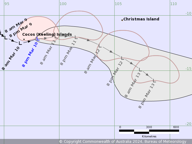
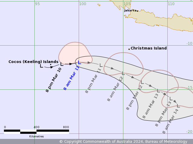
A Tropical Low was located at 12:30 pm CCT (2:00 pm AWST) near 12.4S 97.1E,
that is 40 km southeast of Cocos (Keeling) Islands and 960 km west southwest of
Christmas Island and moving east at 12 kilometres per hour.
Tropical low 08U, located close to the south of Cocos (Keeling) Islands is
moving to the east. It is expected to move east southeast from tomorrow. The
low is not likely to develop into a tropical cyclone on Monday but has an
increasing chance of doing so during the week as it moves towards the
eastsoutheast.
The monsoon flow associated with the low will bring increasing showers, heavy
rainfall, and thunderstorms to the Cocos (Keeling) Islands from tonight. A
period of strong to gale force winds are possible tonight and early Monday.
Winds are expected to begin easing during Monday as the low moves further away
to the southeast.
Winds may increase about the Christmas Island from late Monday as the monsoon
strengthens over the area. Gales are not expected over Christmas Island as 08U
is likely to pass well to the south of the island.
The next Information Bulletin will be issued at 8 pm CCT (9 pm AWST).
IDW24000
Australian Bureau of Meteorology
Tropical Cyclone Warning Centre

TROPICAL CYCLONE INFORMATION BULLETIN
Issued at 8:59 pm WST on Sunday 10 March 2024

A Tropical Low was located at 6:30 pm CCT (8:00 pm AWST) near 12.1S 98.1E,
that is 140 km east of Cocos (Keeling) Islands and 850 km west southwest of
Christmas Island and moving east northeast at 15 kilometres per hour.

Tropical low 08U is located to the east of Cocos (Keeling) Islands. It is
expected to continue moving east on Monday before turning towards the southeast
on Tuesday.

The low is not likely to develop into a tropical cyclone on Monday but has an
increasing chance of doing so during the week as it moves towards the
southeast.

Showers, thunderstorms and strong winds are currently being experienced at the
Cocos (Keeling) Islands, but these conditions should ease during Monday as the
low moves away.

Winds are likely to increase about Christmas Island from late Monday and during
as the monsoon strengthens over the area. Although 08U is likely to pass well
to the south of the island, there is a chance that winds may reach gale force
at times on Tuesday morning. Conditions should then ease Tuesday night as 08U
moves away to the southeast.

The next Information Bulletin will be issued at 2 am CCT (3 am AWST).
AXAU01 APRF 101853
IDW27600
TROPICAL CYCLONE TECHNICAL BULLETIN: AUSTRALIA - WESTERN REGION
Issued by AUSTRALIAN BUREAU OF METEOROLOGY TROPICAL CYCLONE WARNING CENTRE
at: 1853 UTC 10/03/2024
Name: Tropical Low
Identifier: 08U
Data At: 1800 UTC
Latitude: 12.1S
Longitude: 98.9E
Location Accuracy: within 30nm (55 km)
Movement Towards: east (080 deg)
Speed of Movement: 9 knots (17 km/h)
Maximum 10-Minute Wind: 40 knots (75 km/h)
Maximum 3-Second Wind Gust: 55 knots (100 km/h)
Central Pressure: 999 hPa
Radius of 34-knot winds NE quadrant: 60 nm (110 km)
Radius of 34-knot winds SE quadrant:
Radius of 34-knot winds SW quadrant:
Radius of 34-knot winds NW quadrant: 100 nm (185 km)
Radius of 48-knot winds NE quadrant:
Radius of 48-knot winds SE quadrant:
Radius of 48-knot winds SW quadrant:
Radius of 48-knot winds NW quadrant:
Radius of 64-knot winds: nm ( km)
Radius of Maximum Winds: nm ( km)
Dvorak Intensity Code: T2.0/2.0/D1.0/24HRS STT:D0.5/06HRS
Pressure of outermost isobar: 1008 hPa
Radius of outermost closed isobar: 200 nm (370 km)
FORECAST DATA
Date/Time : Location : Loc. Accuracy: Max Wind : Central Pressure
(UTC) : degrees : nm (km): knots(km/h): hPa
+06: 11/0000: 12.0S 99.7E: 045 (085): 040 (075): 995
+12: 11/0600: 12.0S 100.5E: 060 (110): 040 (075): 994
+18: 11/1200: 12.0S 101.5E: 070 (125): 040 (075): 995
+24: 11/1800: 12.3S 102.6E: 075 (140): 040 (075): 995
+36: 12/0600: 13.4S 104.8E: 090 (165): 040 (075): 994
+48: 12/1800: 14.5S 106.6E: 115 (215): 040 (075): 994
+60: 13/0600: 15.5S 108.0E: 135 (245): 040 (075): 995
+72: 13/1800: 16.3S 109.0E: 155 (290): 040 (075): 994
+96: 14/1800: 18.0S 109.7E: 205 (375): 040 (075): 995
+120: 15/1800: 19.7S 109.1E: 260 (480): 040 (075): 994
REMARKS:
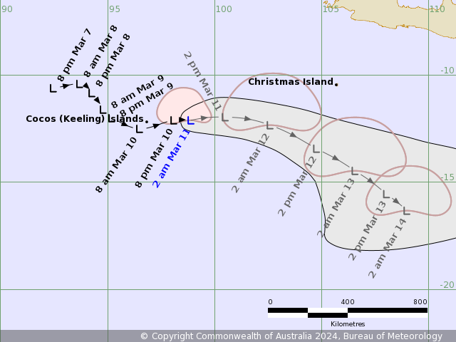
Tropical Low 08U near the Cocos (Keeling) Islands has developed over the last
24 hours along the monsoon trough under moderate to strong easterly shear.
Position with moderate confidence on the 1505Z ASCAT scatterometry and animated
IR satellite imagery. Intensity at 40 knots based on extraploation of
surrounding observations to the more vigorous convection, with gales restricted
to the northern quadrants. Dvorak analysis: DT 2.0 based on curved band 0.3
wrap. MET/PAT 2.0 based on D 24h trend. No objective guidance available.
08U has continued to track east overnight associated with the strengthening
monsoon in the Indian Ocean. 08U is forecast to continue moving east through
today and into Tuesday, before slowly turning towards the southeast through the
week. Sea surface temperatures along this track remain warm at about 29 degrees
Celcius. In the long term, 08U is forecast to move south and then west away
from the WA coastline. As Tropical Low 08U passes to the south of Christmas
Island tomorrow, heavy rain and strong to gale-force winds are likely due to
the strengthening monsoon flow.
Easterly shear is forecast to limit the development of 08U throughout the week,
with only a moderate chance of tropical cyclone development forecast. However,
some modelled scenarios have the vertical wind shear reducing on Friday while
08U remains over warm SSTs, which would be favourable for tropical cyclone
development by the weekend.
Copyright Commonwealth of Australia
==
The next bulletin for this system will be issued by: 11/0130 UTC.
AXAU01 APRF 110139
IDW27600
TROPICAL CYCLONE TECHNICAL BULLETIN: AUSTRALIA - WESTERN REGION
Issued by AUSTRALIAN BUREAU OF METEOROLOGY TROPICAL CYCLONE WARNING CENTRE
at: 0139 UTC 11/03/2024
Name: Tropical Low
Identifier: 08U
Data At: 0000 UTC
Latitude: 11.9S
Longitude: 100.1E
Location Accuracy: within 30nm (55 km)
Movement Towards: east (084 deg)
Speed of Movement: 10 knots (18 km/h)
Maximum 10-Minute Wind: 40 knots (75 km/h)
Maximum 3-Second Wind Gust: 55 knots (100 km/h)
Central Pressure: 996 hPa
Radius of 34-knot winds NE quadrant: 90 nm (165 km)
Radius of 34-knot winds SE quadrant:
Radius of 34-knot winds SW quadrant:
Radius of 34-knot winds NW quadrant: 150 nm (280 km)
Radius of 48-knot winds NE quadrant:
Radius of 48-knot winds SE quadrant:
Radius of 48-knot winds SW quadrant:
Radius of 48-knot winds NW quadrant:
Radius of 64-knot winds:  nm ( km)
Radius of Maximum Winds:   nm (  km)
Dvorak Intensity Code: T2.0/2.0/D1.0/24HRS SST:S0.0/06HRS
Pressure of outermost isobar: 1006 hPa
Radius of outermost closed isobar: 190 nm (350 km)
FORECAST DATA
Date/Time    : Location    : Loc. Accuracy: Max Wind   : Central Pressure
(UTC)        : degrees     :      nm  (km): knots(km/h): hPa
+06:  11/0600: 11.9S 101.2E:     045 (085):  040  (075):  998
+12:  11/1200: 12.2S 102.5E:     055 (105):  040  (075):  997
+18:  11/1800: 12.6S 103.9E:     065 (120):  040  (075):  997
+24:  12/0000: 13.1S 105.0E:     070 (135):  040  (075):  997
+36:  12/1200: 14.1S 107.2E:     090 (165):  045  (085):  996
+48:  13/0000: 15.1S 109.0E:     115 (215):  040  (075):  996
+60:  13/1200: 16.0S 110.4E:     140 (260):  040  (075):  996
+72:  14/0000: 16.8S 111.3E:     165 (305):  045  (085):  996
+96:  15/0000: 18.3S 111.6E:     205 (385):  045  (085):  996
+120: 16/0000: 19.8S 110.5E:     260 (475):  055  (100):  998
REMARKS:
Tropical Low 08U continues to fight against easterly shear as monsoon gales
continue to the north of the system.

Position with moderate confidence on the animated EIR satellite imagery and the
2100Z SSMIS microwave imagery. Intensity at 40 knots based on Dvorak analysis
with gales restricted to the northern quadrants. Dvorak analysis: DT 2.0 based
on shear pattern (less than one degree from tight temperature gradient).
MET/PAT 2.0 based on D 24h trend. No objective guidance available.

08U has continued to track east associated with the strengthening monsoon in
the Indian Ocean. 08U is forecast to continue moving east through today, before
tracking to the southeast for the remainder of the week. In the long term, 08U
is forecast to recurve to the southwest over the weekend, most likely well
offshore of the Western Australian mainland. As Tropical Low 08U passes to the
south of Christmas Island on Tuesday, heavy rain and strong to gale-force winds
are likely due to the strengthening monsoon flow.

Sea surface temperatures along the track remain warm at about 29 degrees
Celsius. Easterly shear is forecast to limit the development of 08U throughout
the week, with only a moderate chance of tropical cyclone development forecast
through to Thursday. From Friday the shear may reduce enough and environment
remains generally favourable that the system develops into a tropical cyclone.
The chances may improve if the system is located a bit further south under the
upper ridge.

Copyright Commonwealth of Australia
==
The next bulletin for this system will be issued by: 11/0730 UTC.