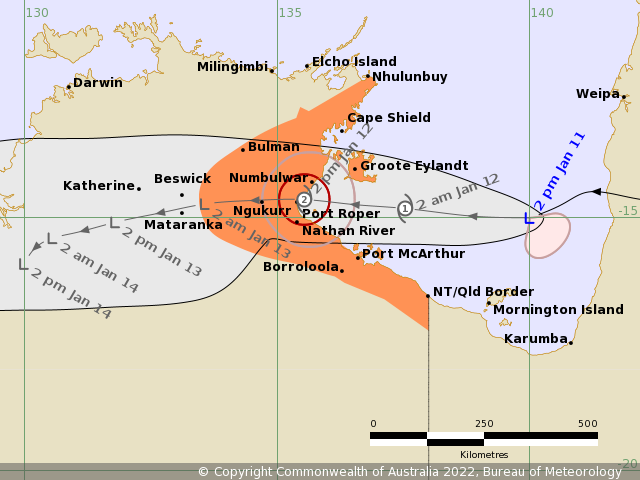
The forecast path shown above is the Bureau's best estimate of the cyclone's future movement and intensity. There is always some uncertainty associated with tropical cyclone forecasting and the grey zone indicates the range of likely tracks of the cyclone centre.
Due to the uncertainty in the future movement, the indicated winds will almost certainly extend to regions outside the rings on this map. The extent of the warning and watch zones reflects this.
This product is designed for land-based communities; mariners should read the coastal waters and high seas warnings.
Headline:
Ex-Tropical Cyclone Tiffany is redeveloping in the Gulf of Carpentaria and will impact the eastern NT coast during Wednesday.
Areas affected:
Warning zone: Nhulunbuy to NT/Qld border, including Groote Eylandt, Numbulwar, Ngukurr, Bulman, Port Roper, and Port McArthur.
Watch zone: None.
Cancelled zones: None.
Details of Ex-Tropical Cyclone Tiffany at 3:30 pm ACST:
Intensity: tropical low, sustained winds near the centre of 65 kilometres per hour with wind gusts to 95 kilometres per hour.
Location: within 30 kilometres of 15.0 degrees South, 140.0 degrees East , 375 kilometres east northeast of Port McArthur and 385 kilometres east southeast of Groote Eylandt .
Movement: west southwest at 18 kilometres per hour .
Ex-Tropical Cyclone Tiffany lies in the Gulf of Carpentaria. It is expected to redevelop into a tropical cyclone overnight or early Wednesday while tracking steadily towards the west. On Wednesday the system will approach the eastern Northern Territory coast where category 2 tropical cyclone impacts are possible. Tropical Cyclone Tiffany will then continue moving westwards, weakening below cyclone strength over land near the base of the Top End on Wednesday night.
Hazards:
GALES are expected to develop about Groote Eylandt and Port McArthur from early Wednesday morning. GALES may develop in remaining parts between Nhulunbuy and the NT/Qld border during Wednesday depending on the track of the system.
The tropical cyclone is expected to cross the coast on Wednesday afternoon, most likely in the area around Port Roper and Nathan River, with DESTRUCTIVE wind gusts to 140 km/h possible close the system centre.
GALES with wind gusts to 100 km/h may extend inland to areas to the east of Beswick late on Wednesday as the cyclone moves inland before weakening.
A STORM TIDE between the NT/Qld border and Cape Shield, including Groote Eylandt, is expected as the cyclone centre passes Groote Eylandt and makes landfall on the mainland coast Wednesday afternoon. Tides are likely to rise significantly above the normal high tide, with DAMAGING WAVES and DANGEROUS FLOODING between the NT/Qld border and Cape Shield, including Groote Eylandt during Wednesday and early Thursday morning.
HEAVY RAIN is likely to develop across parts of the Arnhem and Carpentaria Districts from Wednesday and is expected to cause flooding of low lying areas and river rises. Heavy rain is also likely to extend westwards into the Daly District on Thursday.
Recommended Action:
NTES advises:
- People in the warning zone should be ready for a cyclone and wet/windy conditions.
- Finalise home preparations, know where you will shelter.
- Do not move to public shelters until advised by local authorities
- Move indoors as conditions deteriorate
- Stay informed.
Residents in Alyangula should shelter indoors as winds and rain start later tonight.
The GEMCO Mess will be open to GEMCO staff and Alyangula residents from midnight tonight.
Shelters are available at:
Angurugu School Trade Training Centre - OPEN
Umbakumba School Trade Training Centre – OPEN
Milyakburra Cyclone Shelter – OPEN
For your comfort and safety, follow direction of authorities and Shelter Staff.
Information on how to prepare for a cyclone can be found at www.securent.nt.gov.au
Details:
| |
Time (ACST) |
Intensity Category |
Latitude
(decimal deg.) |
Longitude
(decimal deg.) |
Estimated Position
Accuracy (km) |
| 0hr |
4 pm January 11 |
tropical low |
15.0S |
140.0E |
30 |
| +6hr |
10 pm January 11 |
tropical low |
15.0S |
138.8E |
65 |
| +12hr |
4 am January 12 |
1 |
14.8S |
137.5E |
90 |
| +18hr |
10 am January 12 |
2 |
14.7S |
136.5E |
100 |
| +24hr |
4 pm January 12 |
2 |
14.6S |
135.5E |
115 |
| +36hr |
4 am January 13 |
tropical low |
14.7S |
133.6E |
160 |
| +48hr |
4 pm January 13 |
tropical low |
15.1S |
131.8E |
180 |
| +60hr |
4 am January 14 |
tropical low |
15.4S |
130.6E |
210 |
| +72hr |
4 pm January 14 |
tropical low |
15.9S |
130.0E |
245 |
Tropical Cyclone information is also available in MetEye
最后于 2022-01-11 21:11:19
被哼哼唧唧编辑
,原因: