最新回复 (137)
-

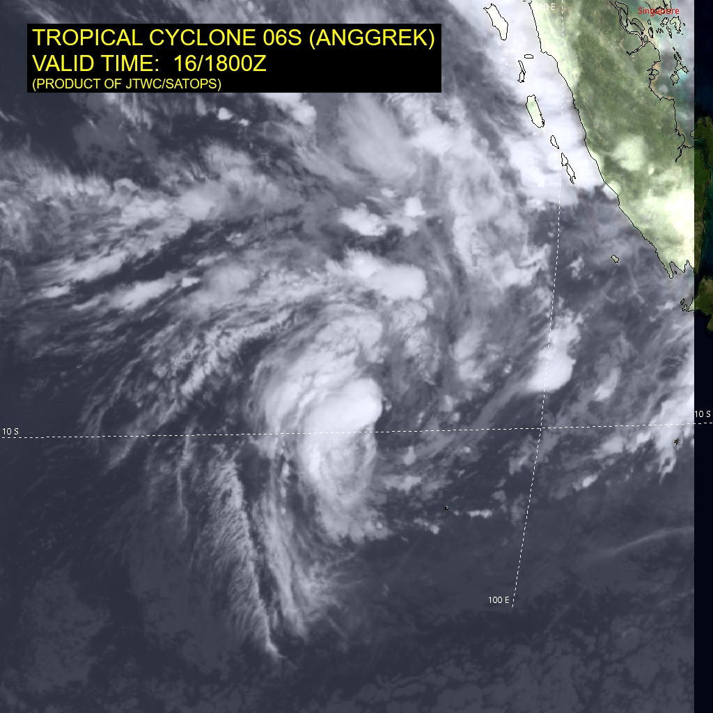
IDW27700
TROPICAL CYCLONE TECHNICAL BULLETIN: AUSTRALIA - WESTERN REGION
Issued by AUSTRALIAN BUREAU OF METEOROLOGY TROPICAL CYCLONE WARNING CENTRE
at: 0057 UTC 16/01/2024
Name: Tropical Cyclone Anggrek
Identifier: 04U
Data At: 0000 UTC
Latitude: 9.4S
Longitude: 93.8E
Location Accuracy: within 30nm (55 km)
Movement Towards: east northeast (071 deg)
Speed of Movement: 2 knots (3 km/h)
Maximum 10-Minute Wind: 40 knots (75 km/h)
Maximum 3-Second Wind Gust: 55 knots (100 km/h)
Central Pressure: 994 hPa
Radius of 34-knot winds NE quadrant: 60 nm (110 km)
Radius of 34-knot winds SE quadrant: 50 nm (95 km)
Radius of 34-knot winds SW quadrant: 40 nm (75 km)
Radius of 34-knot winds NW quadrant: 60 nm (110 km)
Radius of 48-knot winds NE quadrant:
Radius of 48-knot winds SE quadrant:
Radius of 48-knot winds SW quadrant:
Radius of 48-knot winds NW quadrant:
Radius of 64-knot winds:  nm ( km)
Radius of Maximum Winds: 25 nm (45 km)
Dvorak Intensity Code: T3.0/3.0/D0.5/24HRS STT:S0.0/06HRS
Pressure of outermost isobar: 1006 hPa
Radius of outermost closed isobar: 160 nm (295 km)
FORECAST DATA
Date/Time    : Location    : Loc. Accuracy: Max Wind   : Central Pressure
(UTC)        : degrees     :      nm  (km): knots(km/h): hPa
+06:  16/0600:  9.5S  94.0E:     045 (080):  045  (085):  992
+12:  16/1200:  9.5S  94.1E:     055 (100):  045  (085):  991
+18:  16/1800:  9.5S  94.2E:     065 (120):  050  (095):  987
+24:  17/0000:  9.7S  94.3E:     070 (125):  050  (095):  988
+36:  17/1200: 10.4S  94.6E:     070 (135):  055  (100):  985
+48:  18/0000: 11.3S  94.6E:     090 (165):  060  (110):  982
+60:  18/1200: 12.2S  94.6E:     115 (210):  060  (110):  985
+72:  19/0000: 12.7S  94.5E:     140 (260):  060  (110):  985
+96:  20/0000: 12.8S  94.3E:     175 (330):  050  (095):  987
+120: 21/0000: 12.6S  94.1E:     220 (405):  030  (055):  999
REMARKS:
Position estimated based on animated IR imagery and 2126UTC SSMIS pass. Dvorak
analysis: DT 3.0 based on shear pattern with the centre less than 0.5 degrees
from the edge of deep convection. An S trend gives MET of 2.5, with PAT
adjusted to 3.0. FT/CI=3.0. Current objective aids: ADT 34 kn, AiDT 31 kn,
DPRINT 51 kn, SATCON 48 kn (all one-minute means). Intensity maintained at 40
kn.

Recent movement has been slow towards the east northeast.

SSTs are high (>28 degrees C) and remain so along the track. Shear over the
system is low, analysed easterly at around 8 knots at 1800 UTC, however the
displacement of convection to the west of the centre indicates that the system
is affected by this shear. There is some dry air to the south however not
currently a significant influence on development. The CIMSS upper wind analysis
indicates very good upper divergence.

In the short term steering is somewhat balanced between the monsoon flow to the
north and the upper ridge to the south. Anggrek is expected to remain slow
moving with the westerly monsoon flow perhaps assisting with slow eastward
motion. During Wednesday an upper trough amplifies in the Indian Ocean which
weakens the mid-level ridge and Anggrek begins to move to the south. Later in
the week the trough progresses east and the mid-level ridge  rebuilds to the
south of the system. Most deterministic models favour westwards movement in the
longer term however some ensemble members indicate that eastwards movement is
still possible over the weekend. The steering flow may also depend on how
quickly Anggrek weakens with a weaker system caught in the monsoonal westerly
flow with a resulting eastwards movement.

Tropical Cyclone Anggrek is expected to develop further over the next 2 days as
conditions remain generally favourable. However, intensification potential may
be limited by proximity to the shear gradient and by the potential for dry air
to encroach, particularly by later week. Being a small system, Anggrek is
likely to react quickly to changes in the environment. Most models favour slow
intensification through until Thursday and then gradual weakening as conditions
become unfavourable.

Copyright Commonwealth of Australia
==
The next bulletin for this system will be issued by: 16/0730 UTC.
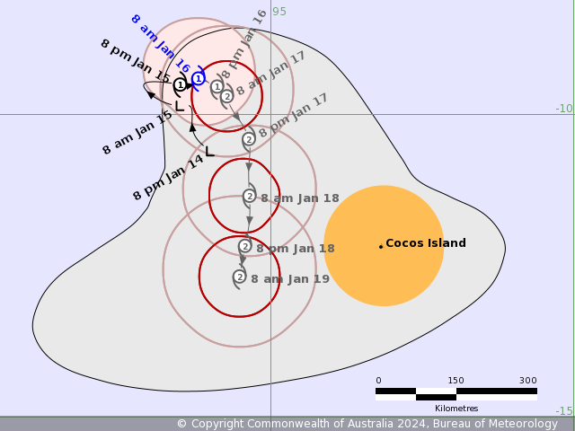
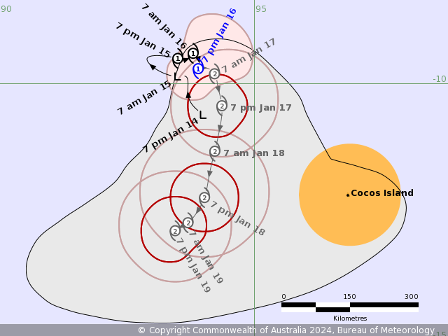
Time (AWST) Intensity Category Latitude
(decimal deg.)Longitude
(decimal deg.)Estimated Position
Accuracy (km)0hr 8 am January 16 1 9.4S 93.8E 55 +6hr 2 pm January 16 1 9.5S 94.0E 80 +12hr 8 pm January 16 1 9.5S 94.1E 100 +18hr 2 am January 17 2 9.5S 94.2E 120 +24hr 8 am January 17 2 9.7S 94.3E 125 +36hr 8 pm January 17 2 10.4S 94.6E 135 +48hr 8 am January 18 2 11.3S 94.6E 165 +60hr 8 pm January 18 2 12.2S 94.6E 210 +72hr 8 am January 19 2 12.7S 94.5E 260 -
IDW27700
TROPICAL CYCLONE TECHNICAL BULLETIN: AUSTRALIA - WESTERN REGION
Issued by AUSTRALIAN BUREAU OF METEOROLOGY TROPICAL CYCLONE WARNING CENTRE
at: 0703 UTC 16/01/2024
Name: Tropical Cyclone Anggrek
Identifier: 04U
Data At: 0600 UTC
Latitude: 9.5S
Longitude: 93.9E
Location Accuracy: within 30nm (55 km)
Movement Towards: east (090 deg)
Speed of Movement: 1 knots (2 km/h)
Maximum 10-Minute Wind: 40 knots (75 km/h)
Maximum 3-Second Wind Gust: 55 knots (100 km/h)
Central Pressure: 994 hPa
Radius of 34-knot winds NE quadrant: 70 nm (130 km)
Radius of 34-knot winds SE quadrant: 30 nm (55 km)
Radius of 34-knot winds SW quadrant: 40 nm (75 km)
Radius of 34-knot winds NW quadrant: 30 nm (55 km)
Radius of 48-knot winds NE quadrant:
Radius of 48-knot winds SE quadrant:
Radius of 48-knot winds SW quadrant:
Radius of 48-knot winds NW quadrant:
Radius of 64-knot winds:  nm ( km)
Radius of Maximum Winds: 20 nm (35 km)
Dvorak Intensity Code: T3.0/3.0/D0.5/24HRS STT:S0.0/6HRS
Pressure of outermost isobar: 1006 hPa
Radius of outermost closed isobar: 160 nm (295 km)
FORECAST DATA
Date/Time    : Location    : Loc. Accuracy: Max Wind   : Central Pressure
(UTC)        : degrees     :      nm  (km): knots(km/h): hPa
+06:  16/1200:  9.5S  94.0E:     045 (080):  040  (075):  994
+12:  16/1800:  9.6S  94.1E:     055 (100):  045  (085):  991
+18:  17/0000:  9.7S  94.2E:     060 (110):  050  (095):  988
+24:  17/0600: 10.1S  94.4E:     060 (115):  055  (100):  985
+36:  17/1800: 10.9S  94.6E:     070 (130):  060  (110):  982
+48:  18/0600: 11.9S  94.6E:     090 (170):  060  (110):  982
+60:  18/1800: 12.5S  94.5E:     110 (205):  060  (110):  985
+72:  19/0600: 12.8S  94.4E:     130 (245):  055  (100):  985
+96:  20/0600: 12.8S  94.3E:     175 (320):  035  (065):  996
+120: 21/0600: 12.6S  94.0E:     205 (380):  030  (055): 1000
REMARKS:
Position estimated based on animated VIS imagery. Dvorak analysis: DT 3.0 based
on shear pattern with the centre less than 0.5 degrees from the edge of deep
convection. An S trend gives MET of 2.5, with PAT adjusted to 3.0. FT/CI=3.0.
Current objective aids: ADT 35 kn, AiDT 35 kn, DPRINT 42 kn, SATCON 40 kn (all
one-minute means). Intensity maintained at 40 kn. Movement has been slow
moving.

SSTs are high (>28 degrees C) and remain so along the track. Shear over the
system is low, analysed easterly at around 5 knots at 0000 UTC, however the
displacement of convection to the west of the centre indicates that the system
is affected a little. The CIMSS upper wind analysis indicates very good upper
divergence.

Tropical Cyclone Anggrek is expected to develop further over the next 2 days as
conditions remain generally favourable. However, intensification potential may
be limited by proximity to the shear gradient and by the potential for dry air
to encroach, particularly by later week. Being a small system, Anggrek is
likely to react quickly to changes in the environment. Most models favour slow
intensification through until Friday and then gradual weakening on the weekend.

In the short term, steering is somewhat balanced between the monsoon flow to
the north and the upper ridge to the south. Hence, expect Anggrek to remain
slow moving. During Wednesday, an upper trough amplifies in the Indian Ocean
which weakens the mid-level ridge and Anggrek begins to move to the south.
Later in the week, the trough progresses east and the mid-level ridge rebuilds
to the south of the system. Most deterministic models favour westwards movement
in the longer term, however some ensemble members indicate eastwards movement
is possible over the weekend, perhaps of a weakened Anggrek.

Copyright Commonwealth of Australia
==
The next bulletin for this system will be issued by: 16/1330 UTC.
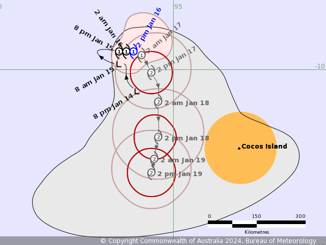
Time (AWST) Intensity Category Latitude
(decimal deg.)Longitude
(decimal deg.)Estimated Position
Accuracy (km)0hr 2 pm January 16 1 9.5S 93.9E 55 +6hr 8 pm January 16 1 9.5S 94.0E 80 +12hr 2 am January 17 1 9.6S 94.1E 100 +18hr 8 am January 17 2 9.7S 94.2E 110 +24hr 2 pm January 17 2 10.1S 94.4E 115 +36hr 2 am January 18 2 10.9S 94.6E 130 +48hr 2 pm January 18 2 11.9S 94.6E 170 +60hr 2 am January 19 2 12.5S 94.5E 205 +72hr 2 pm January 19 2 12.8S 94.4E 245 -
WTXS32 PGTW 160900
MSGID/GENADMIN/JOINT TYPHOON WRNCEN PEARL HARBOR HI//
SUBJ/TROPICAL CYCLONE 06S (ANGGREK) WARNING NR 003//
RMKS/
1. TROPICAL CYCLONE 06S (ANGGREK) WARNING NR 003
   02 ACTIVE TROPICAL CYCLONES IN SOUTHIO
   MAX SUSTAINED WINDS BASED ON ONE-MINUTE AVERAGE
   WIND RADII VALID OVER OPEN WATER ONLY
    ---
   WARNING POSITION:
   160600Z --- NEAR 9.4S 93.8E
     MOVEMENT PAST SIX HOURS - 315 DEGREES AT 01 KTS
     POSITION ACCURATE TO WITHIN 060 NM
     POSITION BASED ON CENTER LOCATED BY SATELLITE
   PRESENT WIND DISTRIBUTION:
   MAX SUSTAINED WINDS - 040 KT, GUSTS 050 KT
   WIND RADII VALID OVER OPEN WATER ONLY
   RADIUS OF 034 KT WINDS - 065 NM NORTHEAST QUADRANT
                            045 NM SOUTHEAST QUADRANT
                            050 NM SOUTHWEST QUADRANT
                            065 NM NORTHWEST QUADRANT
   REPEAT POSIT: 9.4S 93.8E
    ---
   FORECASTS:
   12 HRS, VALID AT:
   161800Z --- 9.6S 94.1E
   MAX SUSTAINED WINDS - 045 KT, GUSTS 055 KT
   WIND RADII VALID OVER OPEN WATER ONLY
   RADIUS OF 034 KT WINDS - 070 NM NORTHEAST QUADRANT
                            060 NM SOUTHEAST QUADRANT
                            080 NM SOUTHWEST QUADRANT
                            070 NM NORTHWEST QUADRANT
   VECTOR TO 24 HR POSIT: 160 DEG/ 03 KTS
    ---
   24 HRS, VALID AT:
   170600Z --- 10.1S 94.3E
   MAX SUSTAINED WINDS - 050 KT, GUSTS 065 KT
   WIND RADII VALID OVER OPEN WATER ONLY
   RADIUS OF 050 KT WINDS - 020 NM NORTHEAST QUADRANT
                            020 NM SOUTHEAST QUADRANT
                            000 NM SOUTHWEST QUADRANT
                            000 NM NORTHWEST QUADRANT
   RADIUS OF 034 KT WINDS - 090 NM NORTHEAST QUADRANT
                            080 NM SOUTHEAST QUADRANT
                            080 NM SOUTHWEST QUADRANT
                            060 NM NORTHWEST QUADRANT
   VECTOR TO 36 HR POSIT: 175 DEG/ 04 KTS
    ---
   36 HRS, VALID AT:
   171800Z --- 10.9S 94.4E
   MAX SUSTAINED WINDS - 060 KT, GUSTS 075 KT
   WIND RADII VALID OVER OPEN WATER ONLY
   RADIUS OF 050 KT WINDS - 040 NM NORTHEAST QUADRANT
                            040 NM SOUTHEAST QUADRANT
                            040 NM SOUTHWEST QUADRANT
                            030 NM NORTHWEST QUADRANT
   RADIUS OF 034 KT WINDS - 100 NM NORTHEAST QUADRANT
                            100 NM SOUTHEAST QUADRANT
                            100 NM SOUTHWEST QUADRANT
                            080 NM NORTHWEST QUADRANT
   VECTOR TO 48 HR POSIT: 200 DEG/ 05 KTS
    ---
   EXTENDED OUTLOOK:
   48 HRS, VALID AT:
   180600Z --- 11.8S 94.1E
   MAX SUSTAINED WINDS - 060 KT, GUSTS 075 KT
   WIND RADII VALID OVER OPEN WATER ONLY
   RADIUS OF 050 KT WINDS - 040 NM NORTHEAST QUADRANT
                            040 NM SOUTHEAST QUADRANT
                            050 NM SOUTHWEST QUADRANT
                            030 NM NORTHWEST QUADRANT
   RADIUS OF 034 KT WINDS - 100 NM NORTHEAST QUADRANT
                            100 NM SOUTHEAST QUADRANT
                            100 NM SOUTHWEST QUADRANT
                            080 NM NORTHWEST QUADRANT
   VECTOR TO 72 HR POSIT: 210 DEG/ 03 KTS
    ---
   72 HRS, VALID AT:
   190600Z --- 12.8S 93.5E
   MAX SUSTAINED WINDS - 050 KT, GUSTS 065 KT
   WIND RADII VALID OVER OPEN WATER ONLY
   RADIUS OF 050 KT WINDS - 000 NM NORTHEAST QUADRANT
                            030 NM SOUTHEAST QUADRANT
                            030 NM SOUTHWEST QUADRANT
                            000 NM NORTHWEST QUADRANT
   RADIUS OF 034 KT WINDS - 080 NM NORTHEAST QUADRANT
                            100 NM SOUTHEAST QUADRANT
                            090 NM SOUTHWEST QUADRANT
                            060 NM NORTHWEST QUADRANT
   VECTOR TO 96 HR POSIT: 225 DEG/ 01 KTS
    ---
   LONG RANGE OUTLOOK:
    ---
   96 HRS, VALID AT:
   200600Z --- 13.1S 93.2E
   MAX SUSTAINED WINDS - 040 KT, GUSTS 050 KT
   WIND RADII VALID OVER OPEN WATER ONLY
   DISSIPATING AS A SIGNIFICANT TROPICAL CYCLONE OVER WATER
   RADIUS OF 034 KT WINDS - 050 NM NORTHEAST QUADRANT
                            080 NM SOUTHEAST QUADRANT
                            080 NM SOUTHWEST QUADRANT
                            050 NM NORTHWEST QUADRANT
   VECTOR TO 120 HR POSIT: 270 DEG/ 01 KTS
    ---
   120 HRS, VALID AT:
   210600Z --- 13.1S 92.7E
   MAX SUSTAINED WINDS - 030 KT, GUSTS 040 KT
   WIND RADII VALID OVER OPEN WATER ONLY
   DISSIPATED AS A SIGNIFICANT TROPICAL CYCLONE OVER WATER
    ---
REMARKS:
160900Z POSITION NEAR 9.5S 93.9E.
16JAN24. TROPICAL CYCLONE 06S (ANGGREK), LOCATED APPROXIMATELY
247 NM NORTHWEST OF COCOS ISLANDS, HAS TRACKED NORTHWESTWARD AT 01
KNOTS OVER THE PAST SIX HOURS. MINIMUM CENTRAL PRESSURE AT 160600Z IS
998 MB. MAXIMUM SIGNIFICANT WAVE HEIGHT AT 160600Z IS 13 FEET. NEXT
WARNINGS AT 162100Z AND 170900Z.
REFER TO TROPICAL CYCLONE 05S (BELAL) WARNINGS (WTXS31 PGTW)
FOR TWELVE-HOURLY UPDATES.
//
NNNN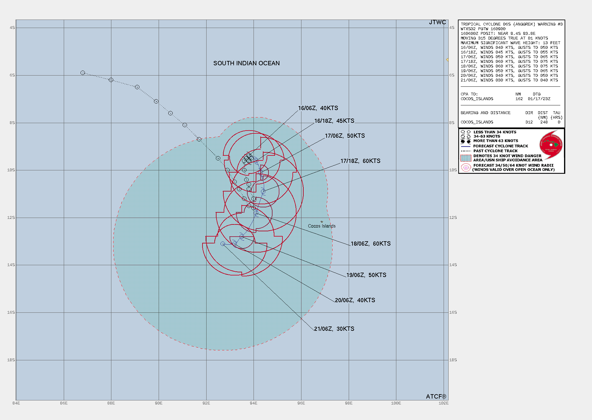
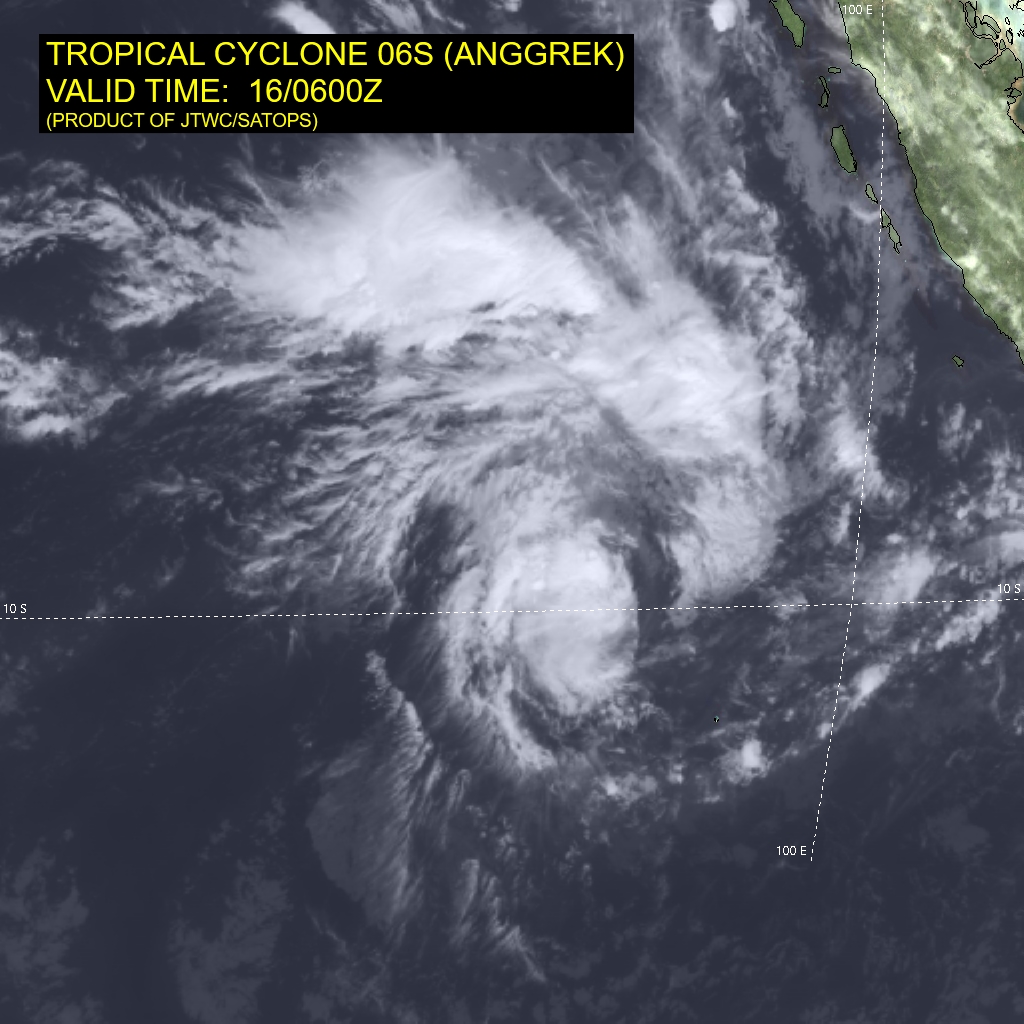
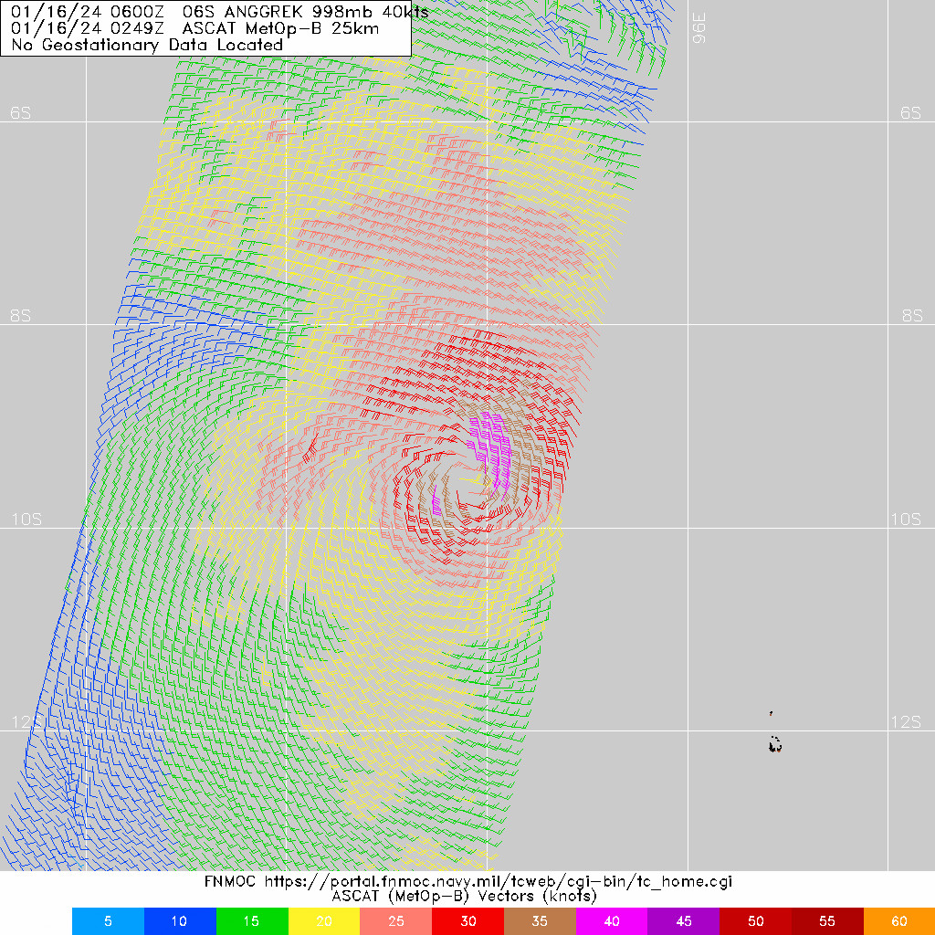
WDXS32 PGTW 160900
MSGID/GENADMIN/JOINT TYPHOON WRNCEN PEARL HARBOR HI//
SUBJ/PROGNOSTIC REASONING FOR TROPICAL CYCLONE 06S (ANGGREK) WARNING
NR 003//
RMKS/
1. FOR METEOROLOGISTS.
2. 6 HOUR SUMMARY AND ANALYSIS.

SUMMARY:
   INITIAL POSITION: 9.4S 93.8E
   INITIAL INTENSITY: 40 KTS
   GEOGRAPHIC REFERENCE: 247 NM NORTHWEST OF COCOS ISLANDS
   MOVEMENT PAST 6 HOURS: NORTHWESTWARD AT 01 KTS
   SIGNIFICANT WAVE HEIGHT: 13 FEET

SATELLITE ANALYSIS, INITIAL POSITION AND INTENSITY DISCUSSION:
ANIMATED MULTISPECTRAL SATELLITE IMAGERY (MSI) DEPICTS TROPICAL
CYCLONE (TC) 06S (ANGGREK) STAGNATING IN A QUASI-STATIONARY POSITION
AS IT HAS HAD LITTLE FORWARD MOMENTUM OVER THE LAST 12 HOURS. DEEP
LAYER CONVECTION PERSISTS BUT IS CONFINED TO THE WESTERN SEMICIRCLE
DUE TO THE INFLUENCE OF PERSISTENT EASTERLY SHEAR VECTOR.
EQUATORWARD OUTFLOW ALOFT IS EVIDENT WITH CIRRUS SHIELDING
EXPANDING TO THE NORTHWEST. DESPITE LOW DEEP LEVEL SHEAR, ESTIMATED
BY CIMSS AT 5 KTS, MID-LEVEL SHEAR IS APPROXIMATELY 25KTS BASED ON
GFS MODEL SOUNDINGS. THE INITIAL POSITION IS PLACED WITH LOW
CONFIDENCE BASED ON ANIMATED MSI AND HIGH-RESOLUTION VISIBLE
IMAGERY DUE TO A LACK OF RECENT MICROWAVE IMAGERY. THE INITIAL
INTENSITY IS BASED ON A 160244Z ASCAT-B PASS SHOWING WIND SPEEDS OF
AROUND 40 KTS, SLIGHTLY LOWER THAN THE AGENCY FIXES THAT ARE ALL AT
T3.0, AND IN LINE WITH THE 40KT SATCON ESTIMATE. ENVIRONMENTAL
ANALYSIS REVEALS A FAVORABLE ENVIRONMENT WITH LOW DEEP LAYER
SHEAR, WITH THE NOTED HIGHER MID-LEVEL SHEAR, MODERATE POLEWARD AND
EQUATORWARD OUTFLOW AND WARM SEA SURFACE TEMPERATURES (28 C). THE
SYSTEM IS TO THE SOUTH OF THE NEAR EQUATORIAL RIDGE (NER), BUT
NORTH OF A SUBTROPICAL RIDGE (STR), WITH A RESULTING WEAK STEERING
ENVIRONMENT.

INITIAL WIND RADII BASIS: SCATTEROMETER DATA

CURRENT STEERING MECHANISM: WEAK STEERING PATTERN WITH NER TO THE
NORTH AND A SUBTROPICAL RIDGE (STR) TO THE SOUTH.

AGENCY DVORAK AND AUTOMATED FIXES:
   PGTW: T3.0 - 45 KTS
   KNES: T3.0 - 45 KTS
   APRF: T3.0 - 45 KTS
   CIMSS SATCON: 40 KTS AT 160630Z
   CIMSS ADT: 35 KTS AT 160530Z

FORECASTER ASSESSMENT OF CURRENT ENVIRONMENT: MARGINALLY FAVORABLE
   VWS: 5-10 KTS
   SST: 28-29 CELSIUS
   OUTFLOW: MODERATE POLEWARD AND EQUATORWARD

ANALYSIS CONFIDENCE:
   INITIAL POSITION: LOW
   INITIAL INTENSITY: MEDIUM
   INITIAL WIND RADII: HIGH

3. FORECAST REASONING.

SIGNIFICANT FORECAST CHANGES: THIS FORECAST INTRODUCES A
DISSIPATION BY THE END OF THE FORECAST PERIOD.

FORECAST DISCUSSION: WHILE CURRENTLY QUASI-STATIONARY, TC 06S WILL
BEGIN TO MOVE OUT SLOWLY TO THE EAST-SOUTHEAST SHORTLY AS THE
GRADIENT WITH THE NER STRENGTHENS, WITH TRACK SPEEDS EXPECTED TO
REMAIN BELOW 3 KNOTS FOR THE NEXT 24 HOURS. BY TAU 48, THE NER WILL
FORM A NORTH-SOUTH RIDGE COMPLEX EAST OF THE SYSTEM, EXTENDING FROM
BORNEO TO THE WEST OF LEARMONTH, AUSTRALIA, FORCING TC 06S TO
TRAVEL SOUTH-SOUTHWEST THROUGH TAU 72. A COMPETING STEERING
ENVIRONMENT SETS UP AFTER TAU 72 AS THE NER PUSHES SOUTH TO NEAR
SINGAPORE, WHILE A STR DEVELOPS TO THE SOUTH OF THE TC, GENERATING
ANOTHER WEAK STEERING PATTERN. THIS WILL CAUSE THE SYSTEM TO SLOW
DOWN TO A CRAWL, OR BECOME QUASI-STATIONARY, THROUGH THE REMAINDER
OF THE FORECAST PERIOD. AS THE STORM MOVES SOUTHWARD, IT MOVES INTO
A SLIGHTLY MORE FAVORABLE ENVIRONMENT WITH THE MID-LEVEL SHEAR
DECREASING SLIGHTLY AND IMPROVES UPPER-LEVEL OUTFLOW WHICH WILL
ALLOW FOR A BRIEF PERIOD OF INTENSIFICATION THROUGH TAU 36. AFTER
TAU 48, THE MID-LEVEL SHEAR (20-25KTS), REDUCED OUTFLOW, AND DRY AIR
ENTRAINMENT WILL CHOKE THE SYSTEM, CAUSING A SLOW BUT STEADY DROP
IN INTENSITY, WITH THE SYSTEM ULTIMATELY ANTICIPATED TO DISSIPATE
BY TAU 120.

MODEL DISCUSSION: GLOBAL NUMERICAL MODEL GUIDANCE IS IN GOOD
AGREEMENT THROUGH TAU 72 THAT THE SYSTEM WILL VEER EAST-SOUTHEAST
AND THEN TO THE SOUTH-SOUTHWEST. CROSS-TRACK SPREAD GRADUALLY
INCREASES TO 175 MILES BY TAU 72, WITH NAVGEM MARKING THE WESTERN
SIDE AND UKMET ENSEMBLE MARKING THE EAST SIDE OF THE GUIDANCE. THE
JTWC TRACK IS CONSISTENT WITH THE GFS AND CONSENSUS MEAN WITH
MEDIUM CONFIDENCE. BEYOND TAU 72, THE MODEL GUIDANCE SPLITS 180
DEGREES WITH A 500 MILE SPREAD BETWEEN NAVGEM TO THE FAR WEST AND
UKMET ENSEMBLE TO THE FAR EAST, RESULTING IN SIGNIFICANT
UNCERTAINTY IN THE TRACK FORECAST THROUGH TAU 120. THE ECENS AND
GEFS ALSO SHOW A 180 DEGREE SPLIT WITH ROUGHLY HALF OF THE MEMBERS
GOING WEST AND HALF GOING EAST, HIGHLIGHTING THE EXTREME
UNCERTAINTY IN THE FORECAST, PARTICULARLY AFTER TAU 72. THE
INTENSITY GUIDANCE ACROSS THE MODELS IS IN GOOD AGREEMENT
THROUGHOUT THE FORECAST PERIOD, PARTICULARLY PEAKING BY TAU 36 AND
REPRESENTING A STEADY DECLINE THROUGH TAU 120.

FORECAST CONFIDENCE:
   TRACK 0 - 72 HR: MEDIUM
   TRACK 72-120 HR: LOW
   INTENSITY 0 - 72 HR: MEDIUM
   INTENSITY 72-120 HR: MEDIUM//
NNNN
-
全球热带气旋监测公报
预报:项素清 签发:高拴柱 2024 年 01 月 16 日 18 时
澳大利亚附近海域热带气旋“安格雷克”生成
时 间:16日14时(北京时)
海 域:澳大利亚附近海域
命 名:“安格雷克”,ANGGREK
中心位置:南纬9.4度、东经93.8度
强度等级:一级热带气旋
最大风力:8级(20米/秒,相当于我国的热带风暴级)
中心气压:994百帕
参考位置:科科斯群岛西北方向约440公里的洋面上
变化过程:“安格雷克”生成并加强到8级
预报结论:“安格雷克”将以每小时10-15公里的速度向东偏南方向移动,强度逐渐增强。
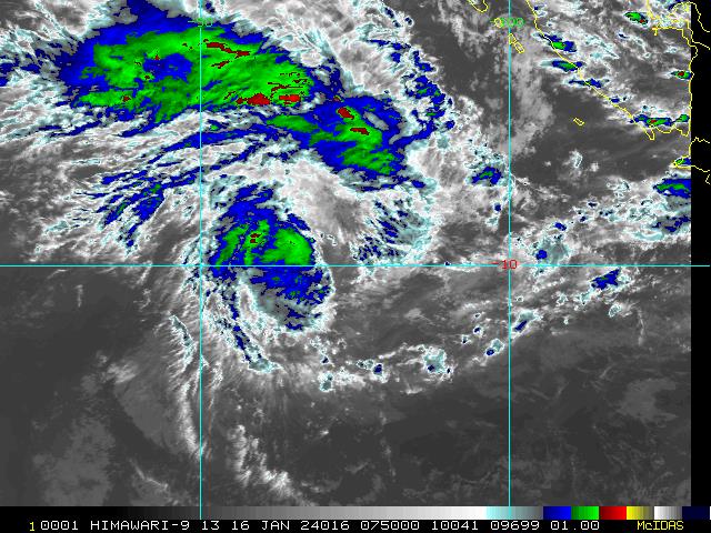
图1 卫星红外监测图像(北京时间2024年01月16日15时00分)
-
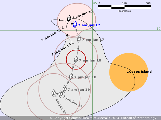
IDW27700
TROPICAL CYCLONE TECHNICAL BULLETIN: AUSTRALIA - WESTERN REGION
Issued by AUSTRALIAN BUREAU OF METEOROLOGY TROPICAL CYCLONE WARNING CENTRE
at: 1306 UTC 16/01/2024
Name: Tropical Cyclone Anggrek
Identifier: 04U
Data At: 1200 UTC
Latitude: 9.7S
Longitude: 93.9E
Location Accuracy: within 20nm (35 km)
Movement Towards: south southeast (162 deg)
Speed of Movement: 2 knots (3 km/h)
Maximum 10-Minute Wind: 40 knots (75 km/h)
Maximum 3-Second Wind Gust: 55 knots (100 km/h)
Central Pressure: 994 hPa
Radius of 34-knot winds NE quadrant: 70 nm (130 km)
Radius of 34-knot winds SE quadrant: 30 nm (55 km)
Radius of 34-knot winds SW quadrant: 40 nm (75 km)
Radius of 34-knot winds NW quadrant: 30 nm (55 km)
Radius of 48-knot winds NE quadrant:
Radius of 48-knot winds SE quadrant:
Radius of 48-knot winds SW quadrant:
Radius of 48-knot winds NW quadrant:
Radius of 64-knot winds:  nm ( km)
Radius of Maximum Winds: 25 nm (45 km)
Dvorak Intensity Code: T3.0/3.0/S0.0/24HRS  STT:S0.0/06HRS
Pressure of outermost isobar: 1006 hPa
Radius of outermost closed isobar: 180 nm (335 km)
FORECAST DATA
Date/Time    : Location    : Loc. Accuracy: Max Wind   : Central Pressure
(UTC)        : degrees     :      nm  (km): knots(km/h): hPa
+06:  16/1800:  9.7S  94.1E:     035 (065):  045  (085):  991
+12:  17/0000:  9.8S  94.2E:     045 (085):  050  (095):  988
+18:  17/0600: 10.0S  94.3E:     055 (100):  055  (100):  985
+24:  17/1200: 10.4S  94.4E:     060 (110):  055  (100):  985
+36:  18/0000: 11.3S  94.2E:     075 (140):  060  (110):  982
+48:  18/1200: 12.2S  94.0E:     095 (180):  060  (110):  982
+60:  19/0000: 12.7S  93.7E:     115 (215):  055  (100):  985
+72:  19/1200: 12.9S  93.4E:     130 (245):  050  (095):  987
+96:  20/1200: 12.8S  93.2E:     160 (300):  030  (055):  999
+120: 21/1200: 12.3S  92.6E:     195 (365):  030  (055):  999
REMARKS:
Tropical Cyclone Anggrek maintains a sheared appearance with the deep
convection remaining slightly offset to the west of the low level centre.

Position estimated based on animated VIS imagery. Dvorak analysis: DT 3.0 based
on shear pattern with the centre less than 0.5 degrees from the edge of deep
convection. A W- trend gives MET of 2.5, with PAT adjusted to 3.0. FT/CI=3.0.
Current objective aids: ADT 35 kn, AiDT 35 kn, DPRINT 46 kn, DMINT 44 kn,
SATCON 39 kn (all one-minute means). Intensity maintained at 40 kn. The system
has been slow moving.

SSTs are high (>28 degrees C) and remain so along the forecast track. CIMSS
upper wind analysis indicates that shear over the system remains low, analysed
easterly at around 5 to 10 knots at 160900 UTC, however the displacement of
convection to the west of the centre indicates that the (small) system is
affected a little by this shear. The CIMSS upper wind analysis indicates very
good upper divergence with good outflow in the southern and western quadrants.

Recent movement has slowed further, with steering from the monsoon flow to the
north becoming balanced by the upper ridge to the south. During Wednesday, an
mid-level trough is forecast to amplify in the Indian Ocean to the west,
pushing the mid-level ridge more to the east of Anggrek. Consequently Anggrek
is expected to move generally to the south through Wednesday and Thursday. It
is forecast to slowly strengthen during this period as generally favourable
conditions and low shear persist.

On Friday the steering pattern becomes very complex, with the main competing
influences being mid-level westerlies to the north of the system, and a
redeveloping ridge to the south. A majority of guidance is indicating that the
ridge will be the dominant steering influence and Anggrek will turn to the
west, however a significant minority suggests the system may instead move to
the east with the northern steering influence being dominant.

In either case, late in the week an upper trough to the south of the system
will relax, and stronger upper easterlies on the northern periphery of the
subtropical ridge are forecast to overlay the system, increasing wind shear and
potential dry air encroachment, causing a weakening trend from about Friday
onwards. The system is forecast to weaken below tropical cyclone strength over
the weekend.

Copyright Commonwealth of Australia
==
The next bulletin for this system will be issued by: 16/1930 UTC.
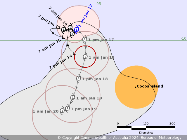
Time (CCT) Intensity Category Latitude
(decimal deg.)Longitude
(decimal deg.)Estimated Position
Accuracy (km)0hr 7 pm January 16 1 9.7S 93.9E 35 +6hr 1 am January 17 1 9.7S 94.1E 65 +12hr 7 am January 17 2 9.8S 94.2E 85 +18hr 1 pm January 17 2 10.0S 94.3E 100 +24hr 7 pm January 17 2 10.4S 94.4E 110 +36hr 7 am January 18 2 11.3S 94.2E 140 +48hr 7 pm January 18 2 12.2S 94.0E 180 +60hr 7 am January 19 2 12.7S 93.7E 215 +72hr 7 pm January 19 2 12.9S 93.4E 245 最后于 2024-01-16 21:10:00 被ygsj24编辑 ,原因: -
IDW27700
TROPICAL CYCLONE TECHNICAL BULLETIN: AUSTRALIA - WESTERN REGION
Issued by AUSTRALIAN BUREAU OF METEOROLOGY TROPICAL CYCLONE WARNING CENTRE
at: 1931 UTC 16/01/2024
Name: Tropical Cyclone Anggrek
Identifier: 04U
Data At: 1800 UTC
Latitude: 9.5S
Longitude: 94.1E
Location Accuracy: within 20nm (35 km)
Movement Towards: east (090 deg)
Speed of Movement: 1 knots (2 km/h)
Maximum 10-Minute Wind: 35 knots (65 km/h)
Maximum 3-Second Wind Gust: 50 knots (95 km/h)
Central Pressure: 997 hPa
Radius of 34-knot winds NE quadrant: 70 nm (130 km)
Radius of 34-knot winds SE quadrant: 30 nm (55 km)
Radius of 34-knot winds SW quadrant: 40 nm (75 km)
Radius of 34-knot winds NW quadrant: 60 nm (110 km)
Radius of 48-knot winds NE quadrant:
Radius of 48-knot winds SE quadrant:
Radius of 48-knot winds SW quadrant:
Radius of 48-knot winds NW quadrant:
Radius of 64-knot winds:  nm ( km)
Radius of Maximum Winds: 25 nm (45 km)
Dvorak Intensity Code: T2.5/3.0/S0.0/24HRS STT:S0.0/06HRS
Pressure of outermost isobar: 1006 hPa
Radius of outermost closed isobar: 140 nm (260 km)
FORECAST DATA
Date/Time    : Location    : Loc. Accuracy: Max Wind   : Central Pressure
(UTC)        : degrees     :      nm  (km): knots(km/h): hPa
+06:  17/0000:  9.7S  94.3E:     035 (065):  040  (075):  994
+12:  17/0600:  9.9S  94.5E:     045 (085):  040  (075):  995
+18:  17/1200: 10.3S  94.5E:     055 (095):  045  (085):  992
+24:  17/1800: 10.8S  94.5E:     060 (110):  050  (095):  989
+36:  18/0600: 11.8S  94.2E:     080 (145):  055  (100):  985
+48:  18/1800: 12.6S  93.9E:     100 (185):  045  (085):  992
+60:  19/0600: 13.1S  93.7E:     120 (220):  040  (075):  994
+72:  19/1800: 13.3S  93.4E:     135 (255):  040  (075):  994
+96:  20/1800: 13.0S  92.7E:     165 (310):  030  (055): 1000
+120: 21/1800: 12.6S  91.7E:     205 (375):  030  (055): 1000
REMARKS:
Tropical Cyclone Anggrek maintains a sheared appearance with the deep
convection remaining slightly offset to the west of the low level centre.

Position estimated based on animated imagery, in particular CIRA ProxyVis.

Dvorak analysis: DT 2.5 or 3.0 based on 0.4 curved band or shear pattern with
the centre less than 0.5 degrees from the edge of deep convection. A W- trend
gives MET of 2.5, with PAT adjusted to 2.5. FT of 2.5, CI of 3.0 due to initial
weakening. Current objective aids that are up to date: ADT 35 kn, AiDT 35 kn,
SATCON 42 kn (all one-minute means). Intensity decreased to 35 kn. The system
has been slow moving.

SSTs are high (>28 degrees C) and remain so along the forecast track. CIMSS
upper wind analysis indicates that shear over the system remains low, analysed
northeasterly at around 12 knots at 161800 UTC, however the displacement of
convection to the west of the centre indicates that the (small) system is
affected a little by this shear. The CIMSS upper wind analysis indicates very
good upper divergence with good outflow in the southern and western quadrants.


Recent movement has been slow and to the east, with steering from the monsoon
flow to the north becoming balanced by the upper ridge to the south. During
Wednesday, an mid-level trough is forecast to amplify in the Indian Ocean to
the west, pushing the mid-level ridge more to the east of Anggrek. Consequently
Anggrek is expected to move generally to the south through Wednesday and
Thursday. Even though there has been some weakening in the cloud pattern, it is
forecast to slowly strengthen during this period as generally favourable
conditions and low shear persist. The timing of reaching category 2 has been
delayed and the maximum intensity has been reduced.

On Friday the steering pattern becomes very complex, with the main competing
influences being mid-level westerlies to the north of the system, and a
redeveloping ridge to the south. A majority of guidance is indicating that the
ridge will be the dominant steering influence and Anggrek will turn to the
west, however a significant minority suggests the system may instead move to
the east with the northern steering influence being dominant.

In either case, late in the week an upper trough to the south of the system
will relax, and stronger upper easterlies on the northern periphery of the
subtropical ridge are forecast to overlay the system, increasing wind shear and
potential dry air encroachment, causing a weakening trend from about Friday
onwards. The system is forecast to weaken below tropical cyclone strength over
the weekend.

Copyright Commonwealth of Australia
==
The next bulletin for this system will be issued by: 17/0130 UTC.
Time (CCT) Intensity Category Latitude
(decimal deg.)Longitude
(decimal deg.)Estimated Position
Accuracy (km)0hr 1 am January 17 1 9.5S 94.1E 35 +6hr 7 am January 17 1 9.7S 94.3E 65 +12hr 1 pm January 17 1 9.9S 94.5E 85 +18hr 7 pm January 17 1 10.3S 94.5E 95 +24hr 1 am January 18 2 10.8S 94.5E 110 +36hr 1 pm January 18 2 11.8S 94.2E 145 +48hr 1 am January 19 1 12.6S 93.9E 185 +60hr 1 pm January 19 1 13.1S 93.7E 220 +72hr 1 am January 20 1 13.3S 93.4E 255 -
WTXS32 PGTW 162100
MSGID/GENADMIN/JOINT TYPHOON WRNCEN PEARL HARBOR HI//
SUBJ/TROPICAL CYCLONE 06S (ANGGREK) WARNING NR 004//
RMKS/
1. TROPICAL CYCLONE 06S (ANGGREK) WARNING NR 004
   02 ACTIVE TROPICAL CYCLONES IN SOUTHIO
   MAX SUSTAINED WINDS BASED ON ONE-MINUTE AVERAGE
   WIND RADII VALID OVER OPEN WATER ONLY
    ---
   WARNING POSITION:
   161800Z --- NEAR 9.5S 94.2E
     MOVEMENT PAST SIX HOURS - 065 DEGREES AT 02 KTS
     POSITION ACCURATE TO WITHIN 060 NM
     POSITION BASED ON CENTER LOCATED BY SATELLITE
   PRESENT WIND DISTRIBUTION:
   MAX SUSTAINED WINDS - 045 KT, GUSTS 055 KT
   WIND RADII VALID OVER OPEN WATER ONLY
   RADIUS OF 034 KT WINDS - 065 NM NORTHEAST QUADRANT
                            045 NM SOUTHEAST QUADRANT
                            050 NM SOUTHWEST QUADRANT
                            065 NM NORTHWEST QUADRANT
   REPEAT POSIT: 9.5S 94.2E
    ---
   FORECASTS:
   12 HRS, VALID AT:
   170600Z --- 10.0S 94.4E
   MAX SUSTAINED WINDS - 055 KT, GUSTS 070 KT
   WIND RADII VALID OVER OPEN WATER ONLY
   RADIUS OF 050 KT WINDS - 030 NM NORTHEAST QUADRANT
                            010 NM SOUTHEAST QUADRANT
                            010 NM SOUTHWEST QUADRANT
                            020 NM NORTHWEST QUADRANT
   RADIUS OF 034 KT WINDS - 090 NM NORTHEAST QUADRANT
                            070 NM SOUTHEAST QUADRANT
                            070 NM SOUTHWEST QUADRANT
                            090 NM NORTHWEST QUADRANT
   VECTOR TO 24 HR POSIT: 185 DEG/ 04 KTS
    ---
   24 HRS, VALID AT:
   171800Z --- 10.8S 94.3E
   MAX SUSTAINED WINDS - 060 KT, GUSTS 075 KT
   WIND RADII VALID OVER OPEN WATER ONLY
   RADIUS OF 050 KT WINDS - 030 NM NORTHEAST QUADRANT
                            020 NM SOUTHEAST QUADRANT
                            020 NM SOUTHWEST QUADRANT
                            040 NM NORTHWEST QUADRANT
   RADIUS OF 034 KT WINDS - 100 NM NORTHEAST QUADRANT
                            080 NM SOUTHEAST QUADRANT
                            080 NM SOUTHWEST QUADRANT
                            090 NM NORTHWEST QUADRANT
   VECTOR TO 36 HR POSIT: 200 DEG/ 05 KTS
    ---
   36 HRS, VALID AT:
   180600Z --- 11.7S 94.0E
   MAX SUSTAINED WINDS - 060 KT, GUSTS 075 KT
   WIND RADII VALID OVER OPEN WATER ONLY
   RADIUS OF 050 KT WINDS - 020 NM NORTHEAST QUADRANT
                            020 NM SOUTHEAST QUADRANT
                            010 NM SOUTHWEST QUADRANT
                            030 NM NORTHWEST QUADRANT
   RADIUS OF 034 KT WINDS - 080 NM NORTHEAST QUADRANT
                            080 NM SOUTHEAST QUADRANT
                            080 NM SOUTHWEST QUADRANT
                            070 NM NORTHWEST QUADRANT
   VECTOR TO 48 HR POSIT: 205 DEG/ 04 KTS
    ---
   EXTENDED OUTLOOK:
   48 HRS, VALID AT:
   181800Z --- 12.5S 93.6E
   MAX SUSTAINED WINDS - 055 KT, GUSTS 070 KT
   WIND RADII VALID OVER OPEN WATER ONLY
   RADIUS OF 050 KT WINDS - 030 NM NORTHEAST QUADRANT
                            010 NM SOUTHEAST QUADRANT
                            020 NM SOUTHWEST QUADRANT
                            020 NM NORTHWEST QUADRANT
   RADIUS OF 034 KT WINDS - 070 NM NORTHEAST QUADRANT
                            070 NM SOUTHEAST QUADRANT
                            080 NM SOUTHWEST QUADRANT
                            070 NM NORTHWEST QUADRANT
   VECTOR TO 72 HR POSIT: 235 DEG/ 03 KTS
    ---
   72 HRS, VALID AT:
   191800Z --- 13.1S 92.7E
   MAX SUSTAINED WINDS - 050 KT, GUSTS 065 KT
   WIND RADII VALID OVER OPEN WATER ONLY
   RADIUS OF 050 KT WINDS - 020 NM NORTHEAST QUADRANT
                            020 NM SOUTHEAST QUADRANT
                            020 NM SOUTHWEST QUADRANT
                            020 NM NORTHWEST QUADRANT
   RADIUS OF 034 KT WINDS - 060 NM NORTHEAST QUADRANT
                            050 NM SOUTHEAST QUADRANT
                            050 NM SOUTHWEST QUADRANT
                            060 NM NORTHWEST QUADRANT
   VECTOR TO 96 HR POSIT: 265 DEG/ 03 KTS
    ---
   LONG RANGE OUTLOOK:
    ---
   96 HRS, VALID AT:
   201800Z --- 13.2S 91.5E
   MAX SUSTAINED WINDS - 040 KT, GUSTS 050 KT
   WIND RADII VALID OVER OPEN WATER ONLY
   RADIUS OF 034 KT WINDS - 050 NM NORTHEAST QUADRANT
                            080 NM SOUTHEAST QUADRANT
                            070 NM SOUTHWEST QUADRANT
                            050 NM NORTHWEST QUADRANT
   VECTOR TO 120 HR POSIT: 270 DEG/ 03 KTS
    ---
   120 HRS, VALID AT:
   211800Z --- 13.2S 90.2E
   MAX SUSTAINED WINDS - 035 KT, GUSTS 045 KT
   WIND RADII VALID OVER OPEN WATER ONLY
   DISSIPATING AS A SIGNIFICANT TROPICAL CYCLONE OVER WATER
   RADIUS OF 034 KT WINDS - 060 NM NORTHEAST QUADRANT
                            080 NM SOUTHEAST QUADRANT
                            080 NM SOUTHWEST QUADRANT
                            060 NM NORTHWEST QUADRANT
    ---
REMARKS:
162100Z POSITION NEAR 9.6S 94.3E.
16JAN24. TROPICAL CYCLONE 06S (ANGGREK), LOCATED APPROXIMATELY 315
NM NORTHWEST OF COCOS ISLANDS, HAS TRACKED EAST-NORTHEASTWARD AT
02 KNOTS OVER THE PAST SIX HOURS. MINIMUM CENTRAL PRESSURE AT
161800Z IS 994 MB. MAXIMUM SIGNIFICANT WAVE HEIGHT AT 161800Z IS
16 FEET. NEXT WARNINGS AT 170900Z AND 172100Z. REFER TO TROPICAL
CYCLONE 05S (BELAL) WARNINGS (WTXS31 PGTW) FOR SIX-HOURLY UPDATES.//
NNNN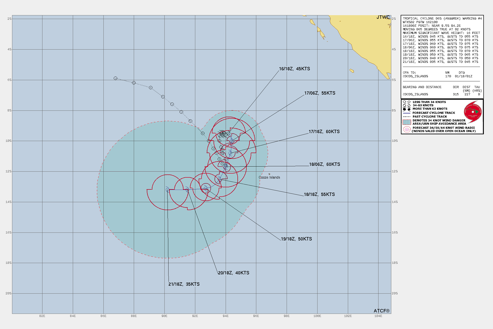
WDXS32 PGTW 162100
MSGID/GENADMIN/JOINT TYPHOON WRNCEN PEARL HARBOR HI//
SUBJ/PROGNOSTIC REASONING FOR TROPICAL CYCLONE 06S (ANGGREK)
WARNING NR 004//
RMKS/
1. FOR METEOROLOGISTS.
2. 6 HOUR SUMMARY AND ANALYSIS.

SUMMARY:
   INITIAL POSITION: 9.5S 94.2E
   INITIAL INTENSITY: 45 KTS
   GEOGRAPHIC REFERENCE: 315 NM NORTHWEST OF COCOS ISLANDS
   MOVEMENT PAST 6 HOURS: EAST-NORTHEASTWARD AT 02 KTS
   SIGNIFICANT WAVE HEIGHT: 16 FEET

SATELLITE ANALYSIS, INITIAL POSITION AND INTENSITY DISCUSSION:
ANIMATED ENHANCED INFRARED (EIR) SATELLITE IMAGERY DEPICTS TROPICAL
CYCLONE 06S (ANGGREK) MAINTAINING A VERY ASYMMETRIC CONVECTIVE
STRUCTURE AS IT SLOWLY TRACKED EASTWARD OVER THE PAST 12 HOURS AT
2KTS. A MOSTLY EXPOSED LOW LEVEL CIRCULATION CENTER (LLCC) IS
OBSERVED THROUGHOUT THE EASTERN SEMICIRCLE WITH LOW AND MID-LEVEL
CLOUD BANDS WRAPPING IN TIGHTLY TO THE LLCC, LACKING DEEP
CONVECTIVE ELEMENTS LIKELY DUE TO THE PERSISTING MID LEVEL EASTERLY
SHEAR (10-15KTS). THE WESTERN PERIPHERY REMAINS PLENTIFULLY
CLUTTERED WITH DEEP CONVECTION AND IN THE NORTHWESTERN QUADRANT
LARGE SPIRAL COULD BANDS PROTRUDE TO THE UPPERMOST LAYERS OF THE
ATMOSPHERE. THE ENVIRONMENT IS ASSESSED AS MARGINALLY FAVORABLE FOR
FURTHER DEVELOPMENT, WITH LOW TO MODERATE (10-17KTS) VERTICAL WIND
SHEAR (VWS), CONDUCIVE (28-29 C) SEA SURFACE TEMPERATURES (SST),
AND MODERATE WESTWARD TO EQUATORWARD DIVERGENT OUTFLOW ALOFT. THE
INITIAL POSITION IS PLACED WITH HIGH CONFIDENCE BASED ON AN EXPOSED
LLCC OBSERVED IN A 161800Z HIMAWARI-9 EIR SATELLITE IMAGE. THE
INITIAL INTENSITY OF 45 KTS IS ASSESSED WITH MEDIUM CONFIDENCE
BASED ON THE SUBJECTIVE AND OBJECTIVE INTENSITY ESTIMATES LISTED
BELOW.

INITIAL WIND RADII BASIS: SCATTEROMETER DATA

CURRENT STEERING MECHANISM: BUILDING NER NORTH OF TC 06S

AGENCY DVORAK AND AUTOMATED FIXES:
   PGTW: T3.0 - 45 KTS
   KNES: T3.0 - 45 KTS
   CIMSS SATCON: 40 KTS AT 161800Z
   CIMSS ADT: 35 KTS AT 161800Z
   CIMSS AIDT: 34 KTS AT 161800Z
   CIMSS DPRINT: 36 KTS AT 161800Z

FORECASTER ASSESSMENT OF CURRENT ENVIRONMENT: MARGINALLY FAVORABLE
   VWS: 10-15 KTS
   SST: 28-29 CELSIUS
   OUTFLOW: MODERATE EQUATORWARD

ANALYSIS CONFIDENCE:
   INITIAL POSITION: HIGH
   INITIAL INTENSITY: MEDIUM
   INITIAL WIND RADII: MEDIUM

3. FORECAST REASONING.

SIGNIFICANT FORECAST CHANGES: THERE ARE NO SIGNIFICANT CHANGES TO
THE FORECAST FROM THE PREVIOUS WARNING.

FORECAST DISCUSSION: TC 06S (ANGGREK) IS ANTICIPATED TO BEGIN
TRACKING SOUTHWARD UNDER THE STEERING INFLUENCE OF A BUILDING NEAR
EQUATORIAL RIDGE NORTH OF THE SYSTEM. ON THIS SOUTHBOUND TRACK, A
MARGINALLY FAVORABLE ENVIRONMENT IS ANTICIPATED TO ALLOW FOR A
SLIGHT GAIN IN INTENSITY, NEARING 60KTS BY TAU 24. AS THE SYSTEM
CONTINUES TO TRACK SOUTHWARD, THE PRIMARY STEERING INFLUENCE SHIFTS
TO A SUBTROPICAL RIDGE AHEAD OF THE SYSTEMS PATH (SOUTH OF THE TC).
THIS FEATURE SLOWLY TURNS THE SYSTEM WESTWARD BY TAU 120. THROUGHOUT
THE DURATION FROM TAU 36 TO TAU 120, THE INFLUENCE OF RELATIVELY DRY
AIR (LESS THAN 50 PERCENT RH) IS ANTICIPATED TO GRADUALLY ENTRAIN THE
SYSTEM, WEAKENING THE TC AND LOWERING INTENSITY.

MODEL DISCUSSION: GLOBAL NUMERICAL MODEL GUIDANCE IS IN GOOD
AGREEMENT THAT TC 06S (ANGGREK) WILL GENERAL TRACK SOUTHWARD WHILE
SLOWLY TURNING TO AN EASTWARD TRACK BY TAU 120. DISREGARDING
MOGREPS AND ECMWF ENSEMBLE MEAN JTWC CONSENSUS MEMBERS, THE CROSS-
TRACK SPREAD AT TAU 72 IS APPROXIMATELY 33NM, SHOWING EXCEPTIONAL
AGREEMENT IN TRACK PATTERN. THE GREATEST INCONSISTENCY BETWEEN
MEMBERS IS SHOWN IN ALONG-TRACK SPREAD, WHICH IS APPROXIMATELY
235NM WITH ECMWF ENSEMBLE MEAN REMOVED FROM CALCULATION. INTENSITY
GUIDANCE PAIRS WELL WITH THE ENVIRONMENTAL ASSESSMENT OF MARGINALLY
FAVORABLE, AND SUGGESTS A SLIGHT INTENSIFICATION (UP TO NEAR 60KT
INTENSITY) IS LIKELY TO OCCUR THROUGH TAU 24, FOLLOWED BY A GRADUAL
WEAKENING TREND THROUGH TAU 120. WITH BOTH TRACK AND INTENSITY MODEL
GUIDANCE SHOWING A COUPLE OF OUTLIERS TO THE DATA PRESENTED, THE
OVERALL CONFIDENCE OF THIS FORECAST IS MEDIUM.

FORECAST CONFIDENCE:
   TRACK 0 - 72 HR: MEDIUM
   TRACK 72-120 HR: MEDIUM
   INTENSITY 0 - 72 HR: MEDIUM
   INTENSITY 72-120 HR: MEDIUM//
NNNN
-
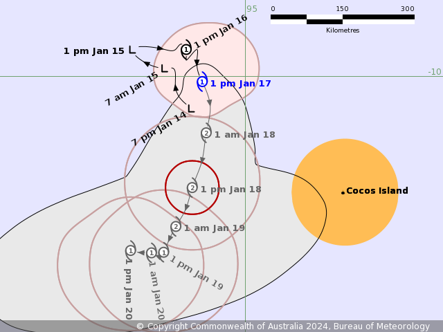
IDW27700
TROPICAL CYCLONE TECHNICAL BULLETIN: AUSTRALIA - WESTERN REGION
Issued by AUSTRALIAN BUREAU OF METEOROLOGY TROPICAL CYCLONE WARNING CENTRE
at: 0149 UTC 17/01/2024
Name: Tropical Cyclone Anggrek
Identifier: 04U
Data At: 0000 UTC
Latitude: 9.7S
Longitude: 94.1E
Location Accuracy: within 20nm (35 km)
Movement Towards: southeast (135 deg)
Speed of Movement: 1 knots (2 km/h)
Maximum 10-Minute Wind: 35 knots (65 km/h)
Maximum 3-Second Wind Gust: 50 knots (95 km/h)
Central Pressure: 995 hPa
Radius of 34-knot winds NE quadrant: 70 nm (130 km)
Radius of 34-knot winds SE quadrant: 30 nm (55 km)
Radius of 34-knot winds SW quadrant: 40 nm (75 km)
Radius of 34-knot winds NW quadrant: 60 nm (110 km)
Radius of 48-knot winds NE quadrant:
Radius of 48-knot winds SE quadrant:
Radius of 48-knot winds SW quadrant:
Radius of 48-knot winds NW quadrant:
Radius of 64-knot winds:  nm ( km)
Radius of Maximum Winds: 25 nm (45 km)
Dvorak Intensity Code: T2.5/3.0/W0.5/24HRS STT:S0.0/06HRS
Pressure of outermost isobar: 1006 hPa
Radius of outermost closed isobar: 150 nm (280 km)
FORECAST DATA
Date/Time    : Location    : Loc. Accuracy: Max Wind   : Central Pressure
(UTC)        : degrees     :      nm  (km): knots(km/h): hPa
+06:  17/0600: 10.1S  94.2E:     040 (070):  040  (075):  995
+12:  17/1200: 10.4S  94.3E:     045 (085):  045  (085):  992
+18:  17/1800: 11.0S  94.3E:     050 (095):  050  (095):  989
+24:  18/0000: 11.5S  94.2E:     055 (105):  055  (100):  986
+36:  18/1200: 12.4S  93.9E:     075 (135):  055  (100):  989
+48:  19/0000: 13.0S  93.6E:     095 (175):  045  (085):  995
+60:  19/1200: 13.3S  93.4E:     110 (205):  040  (075):  994
+72:  20/0000: 13.2S  93.0E:     125 (230):  040  (075):  994
+96:  21/0000: 12.8S  91.9E:     155 (285):  030  (055): 1000
+120: 22/0000: 12.6S  90.5E:     190 (350):  030  (055): 1000
REMARKS:
Tropical Cyclone Anggrek has struggled with shear overnight.

Good confidence in the position which is biased to a recent microwave image at
2348UTC.

Dvorak analysis: DT 2.5 based on 0.4 curved band. A W- trend gives MET of 2.5,
and PAT agrees. FT of 2.5, CI of 3.0. Current objective aids that are up to
date: ADT 35 kn, AiDT 34 kn, SATCON 42 kn, DPRINT 41 kn (all one-minute means).
Intensity set to 35 kn. The system has been slow moving.

SSTs are high (>28 degrees C) and remain so along the forecast track. CIMSS
upper wind analysis indicates that shear over the system remains low, analysed
northeasterly at around 15 knots, however the convection has been displaced to
the west of the centre at times overnight though over the last few hours the
system has shifted under the convection. The CIMSS upper wind analysis
indicates very good upper divergence with good outflow in the southern and
western quadrants.

Recent movement has been slow and to the south, with steering from the monsoon
flow to the north becoming balanced by the upper ridge to the south. During
Wednesday, an mid-level trough is forecast to amplify in the Indian Ocean to
the west, pushing the mid-level ridge more to the east of Anggrek. Consequently
Anggrek is expected to continue to move generally to the south through
Wednesday and Thursday. Even though there has been some weakening in the cloud
pattern, it is forecast to slowly strengthen during this period as generally
favourable conditions and low shear persist. Anggrek is likely to reach
category 2 intensity during Thursday.

On Friday the steering pattern becomes very complex, with the main competing
influences being mid-level westerlies to the north of the system, and a
redeveloping ridge to the south. A majority of guidance is indicating that the
ridge will be the dominant steering influence and Anggrek will turn to the
west, however a significant minority suggests the system may instead move to
the east with the northern steering influence being dominant.

In either case, late in the week an upper trough to the south of the system
will relax, and stronger upper easterlies on the northern periphery of the
subtropical ridge are forecast to overlay the system, increasing wind shear and
potential dry air encroachment, causing a weakening trend from about Friday or
Saturday. The system is forecast to weaken below tropical cyclone strength over
the weekend.

Copyright Commonwealth of Australia
==
The next bulletin for this system will be issued by: 17/0730 UTC.
Time (CCT) Intensity Category Latitude
(decimal deg.)Longitude
(decimal deg.)Estimated Position
Accuracy (km)0hr 7 am January 17 1 9.7S 94.1E 35 +6hr 1 pm January 17 1 10.1S 94.2E 70 +12hr 7 pm January 17 1 10.4S 94.3E 85 +18hr 1 am January 18 2 11.0S 94.3E 95 +24hr 7 am January 18 2 11.5S 94.2E 105 +36hr 7 pm January 18 2 12.4S 93.9E 135 +48hr 7 am January 19 1 13.0S 93.6E 175 +60hr 7 pm January 19 1 13.3S 93.4E 205 +72hr 7 am January 20 1 13.2S 93.0E 230 -
全球热带气旋监测公报
预报:王乃哲 签发:董林 2024 年 01 月 17 日 10 时
“安格雷克”向南偏东方向移动
时 间:17日08时(北京时)
海 域:澳大利亚附近海域
命 名:“安格雷克”,ANGGREK
中心位置:南纬9.8度、东经94.1度
强度等级:一级热带气旋
最大风力:8级(20米/秒,相当于我国的热带风暴级)
中心气压:995百帕
参考位置:科科斯群岛西北方向约400公里的洋面上
变化过程:过去24小时,“安格雷克”强度维持不变
预报结论:“安格雷克”将以每小时10公里左右的速度向南偏东方向移动,强度变化不大。
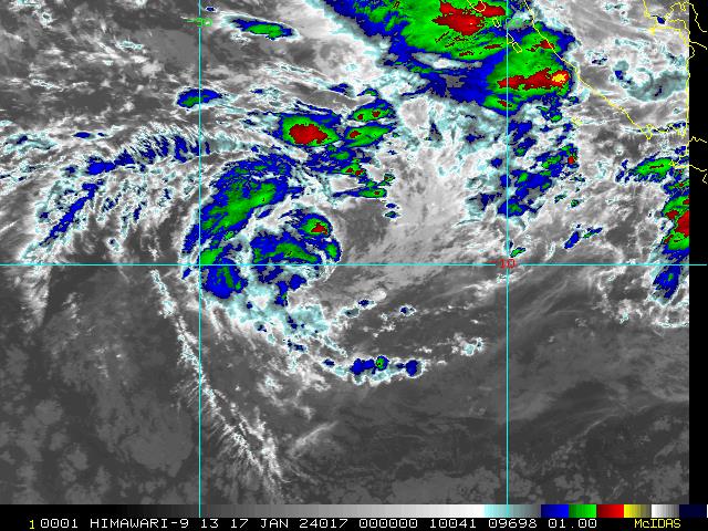
图2 卫星红外监测图像(北京时间2024年01月17日08时00分)
-
IDW27700
TROPICAL CYCLONE TECHNICAL BULLETIN: AUSTRALIA - WESTERN REGION
Issued by AUSTRALIAN BUREAU OF METEOROLOGY TROPICAL CYCLONE WARNING CENTRE
at: 0733 UTC 17/01/2024
Name: Tropical Cyclone Anggrek
Identifier: 04U
Data At: 0600 UTC
Latitude: 10.1S
Longitude: 94.2E
Location Accuracy: within 20nm (35 km)
Movement Towards: south (171 deg)
Speed of Movement: 3 knots (6 km/h)
Maximum 10-Minute Wind: 35 knots (65 km/h)
Maximum 3-Second Wind Gust: 50 knots (95 km/h)
Central Pressure: 995 hPa
Radius of 34-knot winds NE quadrant: 70 nm (130 km)
Radius of 34-knot winds SE quadrant: 40 nm (75 km)
Radius of 34-knot winds SW quadrant: 40 nm (75 km)
Radius of 34-knot winds NW quadrant: 60 nm (110 km)
Radius of 48-knot winds NE quadrant:
Radius of 48-knot winds SE quadrant:
Radius of 48-knot winds SW quadrant:
Radius of 48-knot winds NW quadrant:
Radius of 64-knot winds:  nm ( km)
Radius of Maximum Winds: 25 nm (45 km)
Dvorak Intensity Code: T2.5/3.0/W0.5/24HRS STT:S0.0/06HRS
Pressure of outermost isobar: 1006 hPa
Radius of outermost closed isobar: 150 nm (280 km)
FORECAST DATA
Date/Time    : Location    : Loc. Accuracy: Max Wind   : Central Pressure
(UTC)        : degrees     :      nm  (km): knots(km/h): hPa
+06:  17/1200: 10.6S  94.3E:     035 (065):  045  (085):  992
+12:  17/1800: 11.1S  94.3E:     045 (085):  050  (095):  989
+18:  18/0000: 11.6S  94.2E:     055 (100):  055  (100):  986
+24:  18/0600: 12.1S  94.0E:     065 (115):  055  (100):  986
+36:  18/1800: 12.8S  93.7E:     080 (145):  050  (095):  988
+48:  19/0600: 13.3S  93.5E:     095 (175):  045  (085):  991
+60:  19/1800: 13.3S  93.3E:     110 (200):  045  (085):  991
+72:  20/0600: 13.3S  92.9E:     125 (230):  040  (075):  994
+96:  21/0600: 12.7S  91.5E:     155 (285):  035  (065):  998
+120: 22/0600: 12.7S  90.0E:     185 (340):  030  (055): 1000
REMARKS:
Tropical Cyclone Anggrek is currently moving slowly in a general southerly
direction

The position which is biased to a recent ASCAT image at 0321UTC.

Dvorak analysis: DT 2.5 based on  0.5 curved band. A S trend gives MET of 3.0,
and PAT adjusted to 2.5. FT of 2.5 based on DT and PAT, CI held above FT at
3.0. Current objective aids that are up to date: ADT 37 kn, AiDT 33 kn, SATCON
48 kn, DPRINT 30 kn, DMINT (2348UTC) 38 kn (all one-minute means). Intensity
set to 35 kn.

SSTs are around 28 degrees C along the forecast track. CIMSS upper wind
analysis indicates that shear has increased to around 20 knots northeasterly.
Deep convection has struggled to persist near the system over the last few
hours.

Anggrek is expected to continue to move generally to the south from Wednesday
through to Friday with steering from the monsoon flow to the north dominating.
Even though there has been some weakening in the cloud pattern, it is forecast
to slowly strengthen in the next 24 hours with generally favourable conditions.
Anggrek is likely to reach category 2 intensity during Thursday.

On Friday, the steering pattern becomes more complex due to competing
influences. The primary factors include mid-level westerlies to the north of
the system and a redeveloping ridge to the south. Most guidance suggests that
the ridge will dominate as the steering influence, causing Anggrek to turn
westward. However, a minority of guidance suggests the system may move eastward
with the mid-level westerlies being dominant.

In either case, late in the week an upper trough to the south of the system
will relax, and stronger upper easterlies on the northern periphery of the
subtropical ridge are forecast to overlay the system, increasing wind shear and
potential dry air encroachment, causing a slow weakening trend from about
Friday or Saturday. The system is forecast to weaken below tropical cyclone
strength late weekend.

Copyright Commonwealth of Australia
==
The next bulletin for this system will be issued by: 17/1330 UTC.
Time (CCT) Intensity Category Latitude
(decimal deg.)Longitude
(decimal deg.)Estimated Position
Accuracy (km)0hr 1 pm January 17 1 10.1S 94.2E 35 +6hr 7 pm January 17 1 10.6S 94.3E 65 +12hr 1 am January 18 2 11.1S 94.3E 85 +18hr 7 am January 18 2 11.6S 94.2E 100 +24hr 1 pm January 18 2 12.1S 94.0E 115 +36hr 1 am January 19 2 12.8S 93.7E 145 +48hr 1 pm January 19 1 13.3S 93.5E 175 +60hr 1 am January 20 1 13.3S 93.3E 200 +72hr 1 pm January 20 1 13.3S 92.9E 230