-

全球热带气旋监测公报
预报:宋佳凝 签发:董林 2024 年 01 月 18 日 18 时
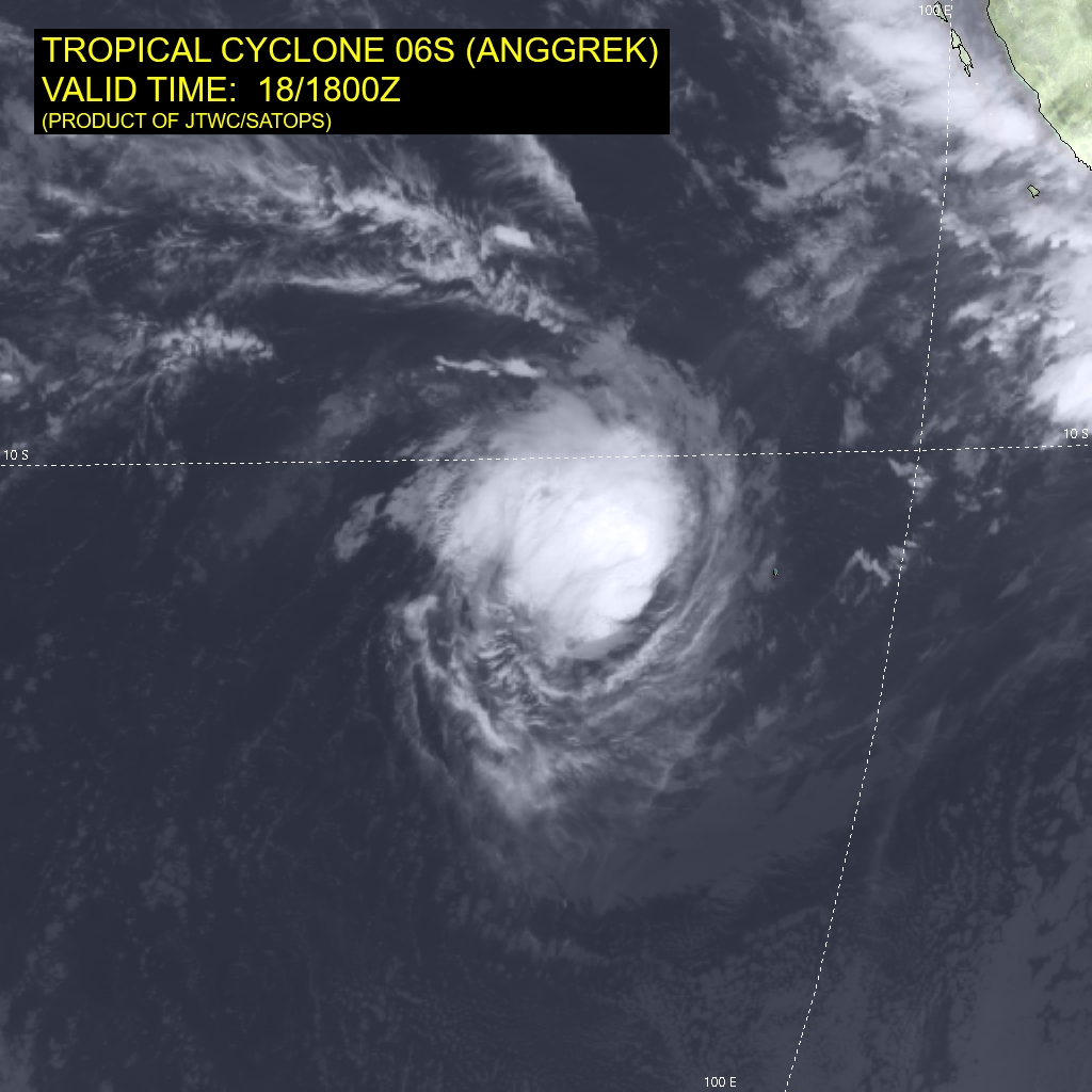
“安格雷克”强度逐渐增强
时 间:18日14时(北京时)
海 域:澳大利亚附近海域
命 名:“安格雷克”,ANGGREK
中心位置:南纬11.3度、东经93.7度
强度等级:一级热带气旋
最大风力:8级(20米/秒,相当于我国的热带风暴级)
中心气压:997百帕
参考位置:科科斯群岛西偏北方向约360公里的洋面上
变化过程:过去24小时,“安格雷克”强度维持不变
预报结论:“安格雷克”将以每小时10公里左右的速度向南偏西方向移动,强度逐渐增强。
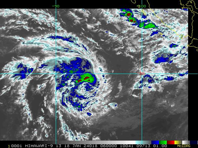
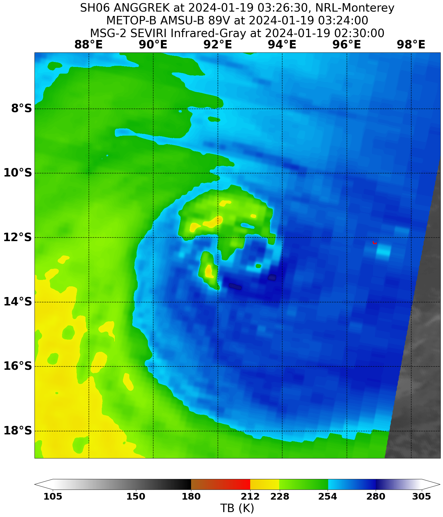
图2 卫星红外监测图像(北京时间2024年01月18日14时00分)
-
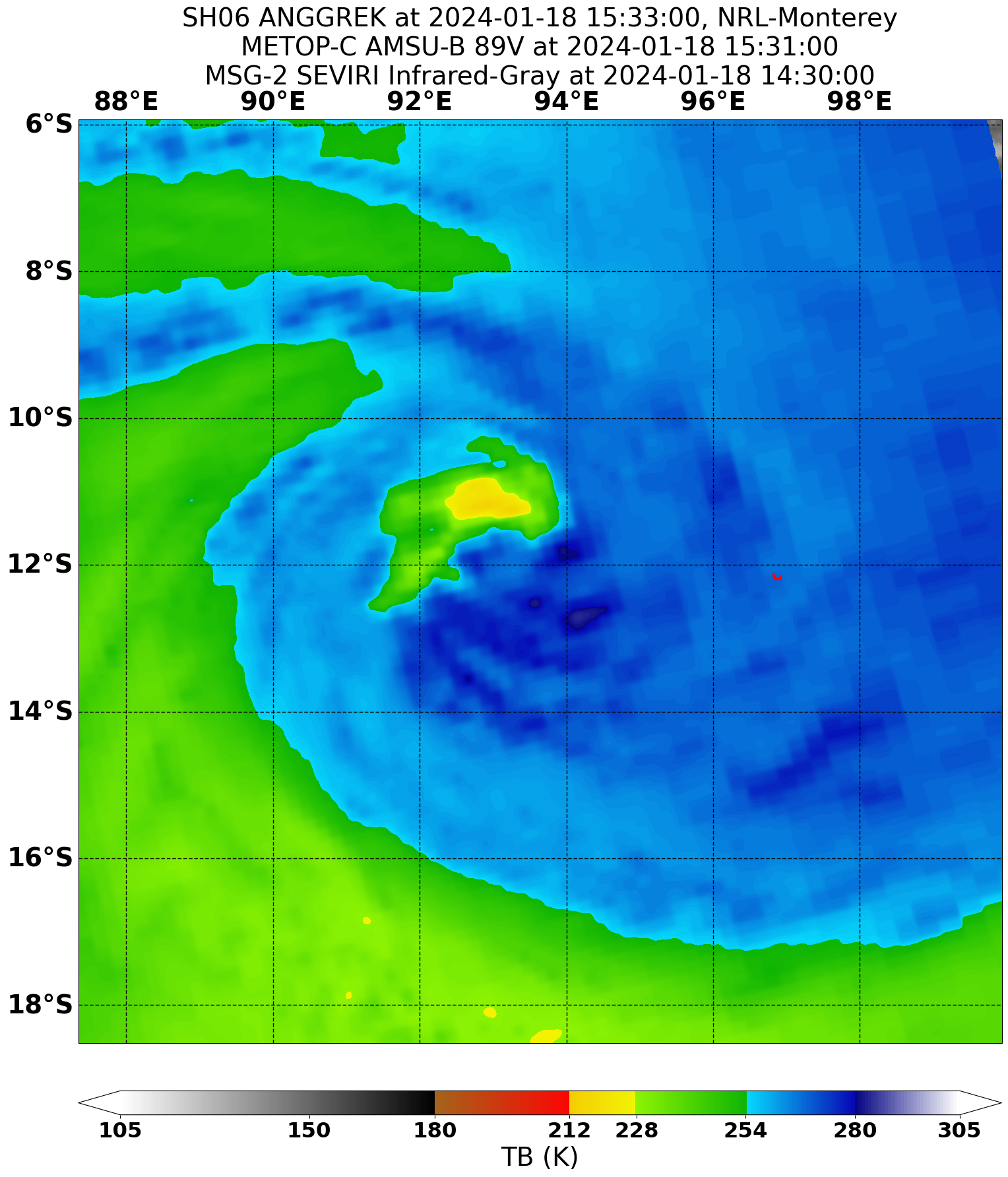
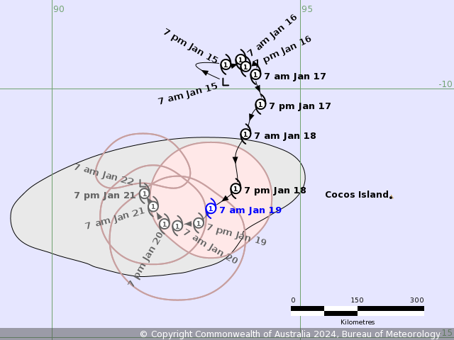
IDW27700
TROPICAL CYCLONE TECHNICAL BULLETIN: AUSTRALIA - WESTERN REGION
Issued by AUSTRALIAN BUREAU OF METEOROLOGY TROPICAL CYCLONE WARNING CENTRE
at: 1328 UTC 18/01/2024
Name: Tropical Cyclone Anggrek
Identifier: 04U
Data At: 1200 UTC
Latitude: 12.0S
Longitude: 93.7E
Location Accuracy: within 30nm (55 km)
Movement Towards: south (190 deg)
Speed of Movement: 6 knots (10 km/h)
Maximum 10-Minute Wind: 35 knots (65 km/h)
Maximum 3-Second Wind Gust: 55 knots (100 km/h)
Central Pressure: 998 hPa
Radius of 34-knot winds NE quadrant: 60 nm (110 km)
Radius of 34-knot winds SE quadrant: 60 nm (110 km)
Radius of 34-knot winds SW quadrant: 60 nm (110 km)
Radius of 34-knot winds NW quadrant: 40 nm (75 km)
Radius of 48-knot winds NE quadrant:
Radius of 48-knot winds SE quadrant:
Radius of 48-knot winds SW quadrant:
Radius of 48-knot winds NW quadrant:
Radius of 64-knot winds:  nm ( km)
Radius of Maximum Winds: 25 nm (45 km)
Dvorak Intensity Code: T3.0/3.0/D0.5/24HRS SST:S0.0/06HRS
Pressure of outermost isobar: 1006 hPa
Radius of outermost closed isobar: 200 nm (370 km)
FORECAST DATA
Date/Time    : Location    : Loc. Accuracy: Max Wind   : Central Pressure
(UTC)        : degrees     :      nm  (km): knots(km/h): hPa
+06:  18/1800: 12.4S  93.5E:     040 (080):  040  (075):  995
+12:  19/0000: 12.7S  93.3E:     050 (095):  045  (085):  992
+18:  19/0600: 12.8S  93.1E:     055 (105):  045  (085):  991
+24:  19/1200: 12.9S  92.9E:     060 (110):  045  (085):  991
+36:  20/0000: 12.9S  92.5E:     060 (110):  040  (075):  994
+48:  20/1200: 12.8S  92.2E:     075 (140):  045  (085):  991
+60:  21/0000: 12.3S  92.0E:     095 (175):  045  (085):  991
+72:  21/1200: 12.0S  91.8E:     105 (195):  040  (075):  994
+96:  22/1200: 11.8S  91.9E:     140 (260):  030  (055):  999
+120: 23/1200: 11.9S  91.6E:     210 (390):  030  (055):  999
REMARKS:
Tropical Cyclone Anggrek is moving slowly south with weakening convection
remaining along the northern periphery.

Recent microwave passes (SSMIS at 09:40Z and GMI at 10:40Z) analysed the
position slightly further east then recent positions suggested. Animated
visible imagery suggested the movement could also be more southerly than south
southwesterly, however with cirrus cover uncertainty increased. Position was
based on a combination of animated visible and EIR imagery and the recent
microwave passes.

Dvorak analysis: Curve band is around 0.4-0.5 wrap with a DT 2.5. MET of 3.0
based on weak developing trend and PAT agrees. FT/CI 3.0. Current objective
aids that are up to date: ADT 41 kn, AiDT 33 kn, DPRINT 48 kn (all one-minute
means). Intensity lowered to 35 knots with system showing signs of weakening.

SSTs are around 28 degrees C along the forecast track. Shear has increased to
around 20-25 knots northeasterly (06:00Z). The system is forecast to fluctuate
between 40-45 kn through to the weekend and early next week. Due to the small
size, it could still reach category 2 for a period.

On Friday, the steering pattern becomes more complex due to competing
influences. The primary factors include mid-level westerlies to the north of
the system and a redeveloping ridge to the south. Most guidance suggests that
the ridge will dominate as the steering influence, causing Anggrek to turn
westward, thought become slow moving for a period early next week. However, a
very small amount of guidance suggests the system may move eastward, with the
mid-level westerlies being dominant. If it does move east, it is likely to
weaken into a tropical low.

In either case, late this week or early next week, an upper trough to the south
of the system will relax, and stronger upper easterlies on the northern
periphery of the subtropical ridge are forecast to overlay the system.
Increasing wind shear and potential dry air encroachment could cause a slow
weakening trend from late Sunday. However, there is a moderate percentage of
guidance scenarios which suggest it might move faster to the west and have the
potential to maintain tropical cyclone intensity and strengthen from early next
week.

Copyright Commonwealth of Australia
==
The next bulletin for this system will be issued by: 18/1930 UTC.
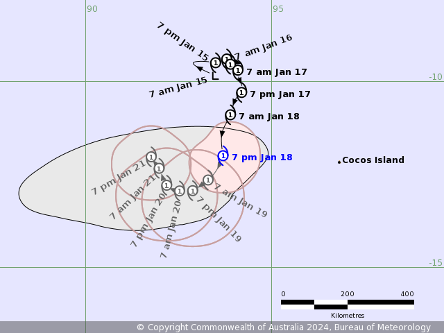
Time (CCT) Intensity Category Latitude
(decimal deg.)Longitude
(decimal deg.)Estimated Position
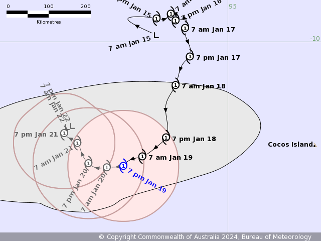
Accuracy (km)0hr 7 pm January 18 1 12.0S 93.7E 55 +6hr 1 am January 19 1 12.4S 93.5E 80 +12hr 7 am January 19 1 12.7S 93.3E 95 +18hr 1 pm January 19 1 12.8S 93.1E 105 +24hr 7 pm January 19 1 12.9S 92.9E 110 +36hr 7 am January 20 1 12.9S 92.5E 110 +48hr 7 pm January 20 1 12.8S 92.2E 140 +60hr 7 am January 21 1 12.3S 92.0E 175 +72hr 7 pm January 21 1 12.0S 91.8E 195 最后于 2024-01-18 21:35:00 被ygsj24编辑 ,原因: -
IDW27700
TROPICAL CYCLONE TECHNICAL BULLETIN: AUSTRALIA - WESTERN REGION
Issued by AUSTRALIAN BUREAU OF METEOROLOGY TROPICAL CYCLONE WARNING CENTRE
at: 1908 UTC 18/01/2024
Name: Tropical Cyclone Anggrek
Identifier: 04U
Data At: 1800 UTC
Latitude: 12.2S
Longitude: 93.5E
Location Accuracy: within 25nm (45 km)
Movement Towards: south southwest (198 deg)
Speed of Movement: 5 knots (9 km/h)
Maximum 10-Minute Wind: 40 knots (75 km/h)
Maximum 3-Second Wind Gust: 55 knots (100 km/h)
Central Pressure: 996 hPa
Radius of 34-knot winds NE quadrant: 60 nm (110 km)
Radius of 34-knot winds SE quadrant: 80 nm (150 km)
Radius of 34-knot winds SW quadrant: 70 nm (130 km)
Radius of 34-knot winds NW quadrant: 70 nm (130 km)
Radius of 48-knot winds NE quadrant:
Radius of 48-knot winds SE quadrant:
Radius of 48-knot winds SW quadrant:
Radius of 48-knot winds NW quadrant:
Radius of 64-knot winds:  nm ( km)
Radius of Maximum Winds: 25 nm (45 km)
Dvorak Intensity Code: T3.0/3.0/D0.5/24HRS SST:S0.0/06HRS
Pressure of outermost isobar: 1008 hPa
Radius of outermost closed isobar: 180 nm (335 km)
FORECAST DATA
Date/Time    : Location    : Loc. Accuracy: Max Wind   : Central Pressure
(UTC)        : degrees     :      nm  (km): knots(km/h): hPa
+06:  19/0000: 12.4S  93.4E:     040 (070):  045  (085):  993
+12:  19/0600: 12.7S  93.2E:     045 (090):  045  (085):  993
+18:  19/1200: 12.8S  93.0E:     050 (095):  045  (085):  993
+24:  19/1800: 12.8S  92.9E:     055 (100):  045  (085):  993
+36:  20/0600: 12.8S  92.5E:     060 (110):  040  (075):  996
+48:  20/1800: 12.5S  92.4E:     070 (135):  045  (085):  993
+60:  21/0600: 12.1S  92.2E:     090 (165):  040  (075):  996
+72:  21/1800: 11.8S  92.3E:     100 (190):  035  (065):  999
+96:  22/1800: 11.6S  92.6E:     135 (255):  030  (055): 1001
+120: 23/1800: 11.9S  92.4E:     190 (355):  030  (055): 1001
REMARKS:
Tropical Cyclone Anggrek is moving slowly south southwest and deep convection
has increased in the northwest during the diurnal favourable time.

Recent microwave imagery at 1209Z (SSMIS) and 1531Z (AMSU-B) provided accurate
low level centre positions. The 1800Z animated EIR position was harder to
locate and persistence of movement was used as well. Position was based on a
combination of animated EIR imagery and the recent microwave passes.

Dvorak analysis: A recent blow up of deeper convection to the northwest of the
low level centre has occurred in the last 3-6 hours and the curvature has been
lost. Shear pattern (<1/3 from gradient) produced a DT of 3.5, however using 3
hour trend produced a more realistic DT of 3.0. MET of 2.5 based on steady
development trend and PAT is 3.0. FT/CI 3.0, based on PAT/3 hourly DT. Current
objective aids that are up to date: ADT 37 kn, AiDT 32 kn, DPRINT 45 kn and
SATCON 51 kn (all one-minute means). SAR pass at 1209Z estimated winds around
45 kn (one minute mean). Intensity set to 40 knots.

SSTs are around 28 degrees C along the forecast track. Shear is around 15-20
knots northeasterly (0600Z CIMSS). The system is forecast to fluctuate between
40-45 kn through to the weekend and early next week. Due to the small size, it
could still reach category 2 for a period.

On Friday, the steering pattern becomes more complex due to competing
influences. The primary factors include mid-level westerlies to the north of
the system and a redeveloping ridge to the south. Most guidance suggests that
the ridge will dominate as the steering influence, causing Anggrek to turn
westward, thought become slow moving for a period early next week. However, a
very small amount of guidance suggests the system may move eastward, with the
mid-level westerlies being dominant. If it does move east, it is likely to
weaken into a tropical low.

In either case, late this week or early next week, an upper trough to the south
of the system will relax, and stronger upper easterlies on the northern
periphery of the subtropical ridge are forecast to overlay the system.
Increasing wind shear and potential dry air encroachment could cause a slow
weakening trend from late Sunday. However, there is a moderate percentage of
guidance scenarios which suggest it might move faster to the west and have the
potential to maintain tropical cyclone intensity and strengthen from early next
week.

Copyright Commonwealth of Australia
==
The next bulletin for this system will be issued by: 19/0130 UTC.
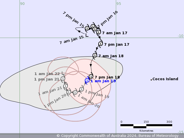
Time (CCT) Intensity Category Latitude
(decimal deg.)Longitude
(decimal deg.)Estimated Position
Accuracy (km)0hr 1 am January 19 1 12.2S 93.5E 45 +6hr 7 am January 19 1 12.4S 93.4E 70 +12hr 1 pm January 19 1 12.7S 93.2E 90 +18hr 7 pm January 19 1 12.8S 93.0E 95 +24hr 1 am January 20 1 12.8S 92.9E 100 +36hr 1 pm January 20 1 12.8S 92.5E 110 +48hr 1 am January 21 1 12.5S 92.4E 135 +60hr 1 pm January 21 1 12.1S 92.2E 165 +72hr 1 am January 22 tropical low 11.8S 92.3E 190 -
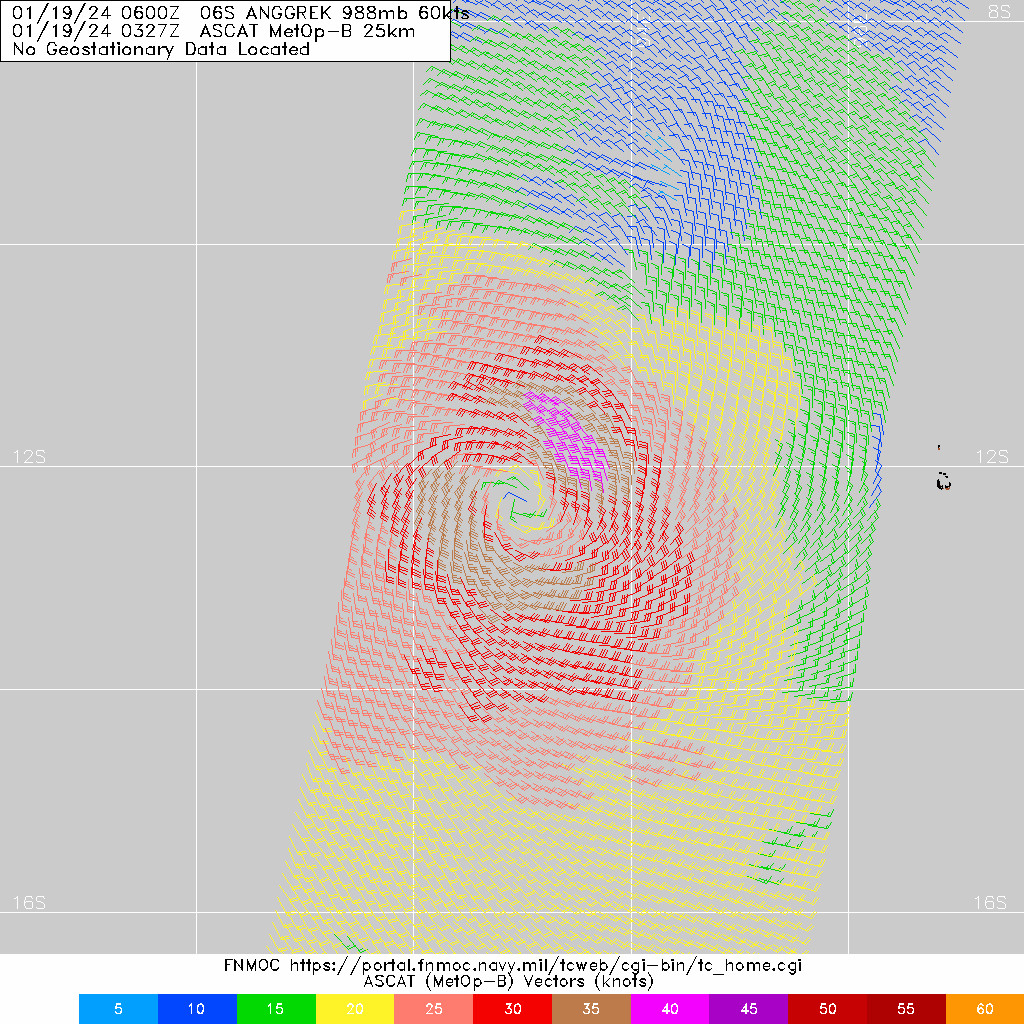
WTXS32 PGTW 182100
MSGID/GENADMIN/JOINT TYPHOON WRNCEN PEARL HARBOR HI//
SUBJ/TROPICAL CYCLONE 06S (ANGGREK) WARNING NR 008//
RMKS/
1. TROPICAL CYCLONE 06S (ANGGREK) WARNING NR 008
   02 ACTIVE TROPICAL CYCLONES IN SOUTHIO
   MAX SUSTAINED WINDS BASED ON ONE-MINUTE AVERAGE
   WIND RADII VALID OVER OPEN WATER ONLY
    ---
   WARNING POSITION:
   181800Z --- NEAR 12.2S 93.2E
     MOVEMENT PAST SIX HOURS - 245 DEGREES AT 04 KTS
     POSITION ACCURATE TO WITHIN 050 NM
     POSITION BASED ON CENTER LOCATED BY SATELLITE
   PRESENT WIND DISTRIBUTION:
   MAX SUSTAINED WINDS - 045 KT, GUSTS 055 KT
   WIND RADII VALID OVER OPEN WATER ONLY
   RADIUS OF 034 KT WINDS - 070 NM NORTHEAST QUADRANT
                            070 NM SOUTHEAST QUADRANT
                            065 NM SOUTHWEST QUADRANT
                            095 NM NORTHWEST QUADRANT
   REPEAT POSIT: 12.2S 93.2E
    ---
   FORECASTS:
   12 HRS, VALID AT:
   190600Z --- 12.7S 92.8E
   MAX SUSTAINED WINDS - 050 KT, GUSTS 065 KT
   WIND RADII VALID OVER OPEN WATER ONLY
   RADIUS OF 050 KT WINDS - 020 NM NORTHEAST QUADRANT
                            000 NM SOUTHEAST QUADRANT
                            000 NM SOUTHWEST QUADRANT
                            020 NM NORTHWEST QUADRANT
   RADIUS OF 034 KT WINDS - 070 NM NORTHEAST QUADRANT
                            080 NM SOUTHEAST QUADRANT
                            070 NM SOUTHWEST QUADRANT
                            090 NM NORTHWEST QUADRANT
   VECTOR TO 24 HR POSIT: 245 DEG/ 02 KTS
    ---
   24 HRS, VALID AT:
   191800Z --- 12.9S 92.4E
   MAX SUSTAINED WINDS - 050 KT, GUSTS 065 KT
   WIND RADII VALID OVER OPEN WATER ONLY
   RADIUS OF 050 KT WINDS - 020 NM NORTHEAST QUADRANT
                            000 NM SOUTHEAST QUADRANT
                            000 NM SOUTHWEST QUADRANT
                            010 NM NORTHWEST QUADRANT
   RADIUS OF 034 KT WINDS - 060 NM NORTHEAST QUADRANT
                            070 NM SOUTHEAST QUADRANT
                            060 NM SOUTHWEST QUADRANT
                            080 NM NORTHWEST QUADRANT
   VECTOR TO 36 HR POSIT: 270 DEG/ 02 KTS
    ---
   36 HRS, VALID AT:
   200600Z --- 12.9S 92.0E
   MAX SUSTAINED WINDS - 050 KT, GUSTS 065 KT
   WIND RADII VALID OVER OPEN WATER ONLY
   RADIUS OF 050 KT WINDS - 000 NM NORTHEAST QUADRANT
                            000 NM SOUTHEAST QUADRANT
                            000 NM SOUTHWEST QUADRANT
                            020 NM NORTHWEST QUADRANT
   RADIUS OF 034 KT WINDS - 050 NM NORTHEAST QUADRANT
                            050 NM SOUTHEAST QUADRANT
                            050 NM SOUTHWEST QUADRANT
                            070 NM NORTHWEST QUADRANT
   VECTOR TO 48 HR POSIT: 290 DEG/ 02 KTS
    ---
   EXTENDED OUTLOOK:
   48 HRS, VALID AT:
   201800Z --- 12.8S 91.7E
   MAX SUSTAINED WINDS - 050 KT, GUSTS 065 KT
   WIND RADII VALID OVER OPEN WATER ONLY
   RADIUS OF 050 KT WINDS - 000 NM NORTHEAST QUADRANT
                            020 NM SOUTHEAST QUADRANT
                            020 NM SOUTHWEST QUADRANT
                            020 NM NORTHWEST QUADRANT
   RADIUS OF 034 KT WINDS - 050 NM NORTHEAST QUADRANT
                            050 NM SOUTHEAST QUADRANT
                            050 NM SOUTHWEST QUADRANT
                            060 NM NORTHWEST QUADRANT
   VECTOR TO 72 HR POSIT: 295 DEG/ 02 KTS
    ---
   72 HRS, VALID AT:
   211800Z --- 12.5S 91.0E
   MAX SUSTAINED WINDS - 050 KT, GUSTS 065 KT
   WIND RADII VALID OVER OPEN WATER ONLY
   RADIUS OF 050 KT WINDS - 020 NM NORTHEAST QUADRANT
                            020 NM SOUTHEAST QUADRANT
                            020 NM SOUTHWEST QUADRANT
                            030 NM NORTHWEST QUADRANT
   RADIUS OF 034 KT WINDS - 050 NM NORTHEAST QUADRANT
                            050 NM SOUTHEAST QUADRANT
                            060 NM SOUTHWEST QUADRANT
                            080 NM NORTHWEST QUADRANT
   VECTOR TO 96 HR POSIT: 295 DEG/ 02 KTS
    ---
   LONG RANGE OUTLOOK:
    ---
   96 HRS, VALID AT:
   221800Z --- 12.2S 90.4E
   MAX SUSTAINED WINDS - 045 KT, GUSTS 055 KT
   WIND RADII VALID OVER OPEN WATER ONLY
   RADIUS OF 034 KT WINDS - 040 NM NORTHEAST QUADRANT
                            050 NM SOUTHEAST QUADRANT
                            040 NM SOUTHWEST QUADRANT
                            060 NM NORTHWEST QUADRANT
   VECTOR TO 120 HR POSIT: 300 DEG/ 01 KTS
    ---
   120 HRS, VALID AT:
   231800Z --- 11.9S 89.9E
   MAX SUSTAINED WINDS - 045 KT, GUSTS 055 KT
   WIND RADII VALID OVER OPEN WATER ONLY
   RADIUS OF 034 KT WINDS - 040 NM NORTHEAST QUADRANT
                            080 NM SOUTHEAST QUADRANT
                            070 NM SOUTHWEST QUADRANT
                            080 NM NORTHWEST QUADRANT
    ---
REMARKS:
182100Z POSITION NEAR 12.3S 93.1E. 18JAN24.
TROPICAL CYCLONE 06S (ANGGREK), LOCATED APPROXIMATELY
1261 NM EAST-SOUTHEAST OF DIEGO GARCIA, HAS TRACKED
WEST-SOUTHWESTWARD AT 04 KNOTS OVER THE PAST SIX HOURS.
MINIMUM CENTRAL PRESSURE AT 181800Z IS 993 MB.
MAXIMUM SIGNIFICANT WAVE HEIGHT AT 181800Z IS 20 FEET.
NEXT WARNINGS AT 190900Z AND 192100Z.
REFER TO TROPICAL CYCLONE 05S (BELAL) WARNINGS
(WTXS31 PGTW) FOR TWELVE-HOURLY UPDATES.
//
NNNN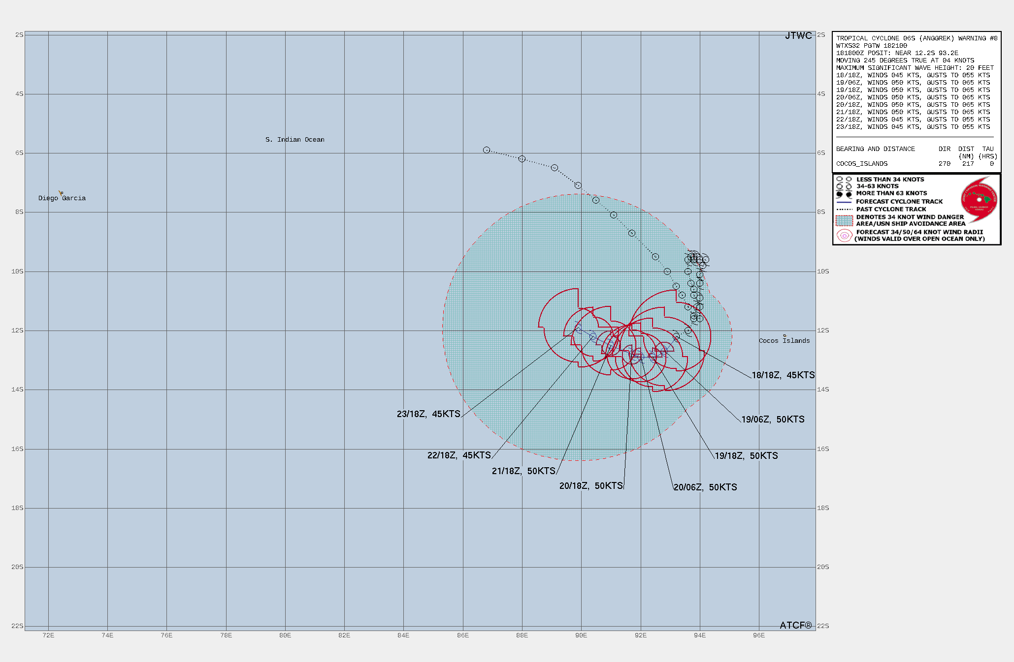
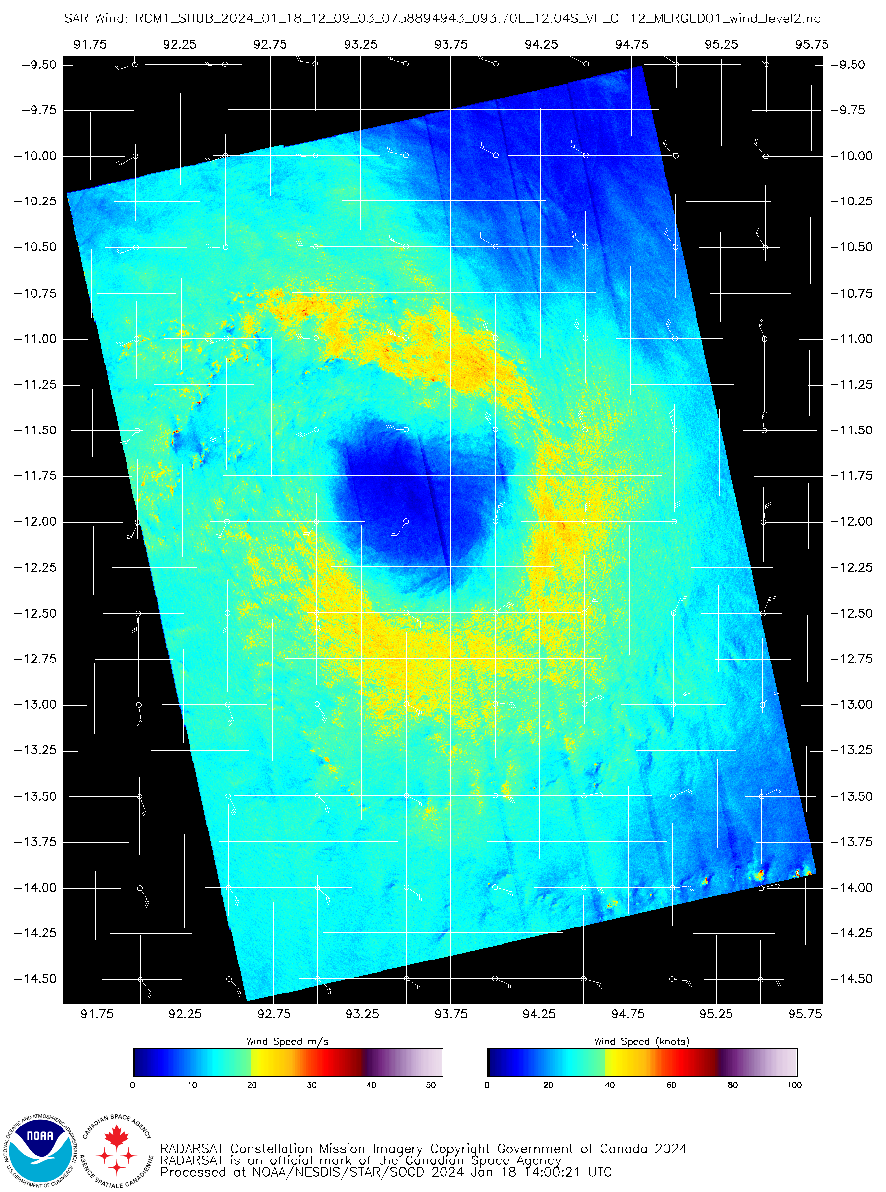
WDXS32 PGTW 182100
MSGID/GENADMIN/JOINT TYPHOON WRNCEN PEARL HARBOR HI//
SUBJ/PROGNOSTIC REASONING FOR TROPICAL CYCLONE 06S (ANGGREK) WARNING
NR 008//
RMKS/
1. FOR METEOROLOGISTS.
2. 6 HOUR SUMMARY AND ANALYSIS.

SUMMARY:
   INITIAL POSITION: 12.2S 93.2E
   INITIAL INTENSITY: 45 KTS
   GEOGRAPHIC REFERENCE: 1261 NM EAST-SOUTHEAST OF DIEGO GARCIA
   MOVEMENT PAST 6 HOURS: WEST-SOUTHWESTWARD AT 04 KTS
   SIGNIFICANT WAVE HEIGHT: 20 FEET

SATELLITE ANALYSIS, INITIAL POSITION AND INTENSITY DISCUSSION:
ANIMATED MULTISPECTRAL SATELLITE IMAGERY (MSI) DEPICTS DEEP
CONVECTIVE STRUCTURES FLARING DIRECTLY OVER THE ASSESSED LOW-LEVEL
CIRCULATION (LLC) AND ATTEMPTING TO WRAP CYCLONICALLY AROUND THE
EASTERN SEMICIRCLE. AN 181531Z 89GHZ MICROWAVE PASS SHOWS THE
MAJORITY OF ASSOCIATED CONVECTION SLIGHTLY WRAPPED AROUND THE
NORTHERN SEMICIRCLE, WITH SHALLOW LOW-LEVEL BANDING CURVED INTO THE
CENTER FROM THE SOUTHEAST, WHICH SUPPORTS THE INITIAL POSITION WITH
MEDIUM CONFIDENCE. AN EARLIER 181209Z SYNTHETIC APERTURE RADAR
(SAR) PASS SUPPORTS INITIAL INTENSITY ASSESSMENT IN HIGH
CONFIDENCE, INDICATING A 45 KTS WIND RADII OF 75 NM ENCIRCLING THE
MAJORITY OF THE NOW-OBSCURED CIRCULATION CENTER, WITH THE EXCEPTION
OF THE NORTHWEST QUADRANT, BEING HEAVILY INFLUENCED BY A SURGE OF
INCREASING DRY AIR FROM THE WEST ATTEMPTING TO ENGULF TC 06S.

INITIAL WIND RADII BASIS: SAR DATA

CURRENT STEERING MECHANISM: SUBTROPICAL RIDGE (STR) TO THE EAST AND
SOUTH.

AGENCY DVORAK AND AUTOMATED FIXES:
   PGTW: T3.0 - 45 KTS
   KNES: T3.0 - 45 KTS
   DEMS: T3.0 - 45 KTS
   FMEE: T3.5 - 55 KTS
   CIMSS SATCON: 51 KTS AT 181531Z
   CIMSS ADT: 37 KTS AT 181730Z

FORECASTER ASSESSMENT OF CURRENT ENVIRONMENT: MARGINALLY FAVORABLE
   VWS: 15-20 KTS
   SST: 26-27 CELSIUS
   OUTFLOW: WEAK POLEWARD AND EQUATORWARD

ANALYSIS CONFIDENCE:
   INITIAL POSITION: MEDIUM
   INITIAL INTENSITY: HIGH
   INITIAL WIND RADII: LOW

3. FORECAST REASONING.

SIGNIFICANT FORECAST CHANGES: THERE ARE NO SIGNIFICANT CHANGES TO
THE FORECAST FROM THE PREVIOUS WARNING.

FORECAST DISCUSSION: TROPICAL CYCLONE (TC) 06S IS SLOWLY
PROGRESSING GENERALLY TO THE SOUTHWEST ALONG AN EXTENSION OF THE
DEEP-LEVEL STEERING RIDGE TO THE SOUTHEAST THROUGH TAU 24.
FOLLOWING TAU 24, TC 06S WILL CONTINUE TO TRACK SLOWLY AND MORE
WESTWARD AND NORTHWESTWARD ALONG THE NORTHEASTERN EDGE OF THE
WELL-ESTABLISHED AND BUILDING STR TO THE SOUTH. TC 06S IS
FORECASTED TO INTENSIFY TO 50 KTS THROUGH TAU 12 AS A MARGINALLY
FAVORABLE ENVIRONMENT CONTINUES TO ALLOW FOR FAVORABLE OUTFLOW
POLEWARD AND EQUATORWARD; HOWEVER, THE CURRENT MARGINALLY FAVORABLE
ENVIRONMENT CHARACTERIZED BY MODERATE DUAL OUTFLOW AND WARM SST OFFSET
BY DRY AIR INTRUSION AND MODERATE VERTICAL WIND SHEAR (VWS) WILL ALLOW
TC 06S TO MAINTAIN INTENSITY NEAR 45 TO 50 KTS UNTIL THE END OF THE
FORECAST PERIOD.

MODEL DISCUSSION: GENERALLY, NUMERICAL MODEL GUIDANCE REMAINS IN
FAIR AGREEMENT SUPPORTING THE JTWC FORECAST TRACK THROUGH TAU 24.
AFTER TAU 24, MODEL GUIDANCE DIVERGES WITH CONTINUED AND INCREASING
UNCERTAINTY AS TC 06S IS FORECASTED TO TRACK WEST-NORTHWESTWARD
WITH A SLOW AND STEADY SPEED. THE LATEST ECMWF PROBABILISTIC
GUIDANCE INDICATES A SLOW PROGRESSION TO THE WEST-SOUTHWEST, WHILE
THE GFS TRACKER BECOMES ERRATIC IN EXACT CYCLONE PLACEMENT PAST TAU
36, BUT IS GENERALLY WESTWARD. FOLLOWING TAU 24, DRY AIR
ENTRAINMENT AND UNFAVORABLE VWS IS EXPECTED TO SIGNIFICANTLY LIMIT
ANY FURTHER INTENSIFICATION PAST 50 KTS, SLOWLY DECREASING
INTENSITY FOR TC 06S THROUGH THE END OF THE FORECAST PERIOD.

FORECAST CONFIDENCE:
   TRACK 0 - 72 HR: MEDIUM
   TRACK 72-120 HR: LOW
   INTENSITY 0 - 72 HR: MEDIUM
   INTENSITY 72-120 HR: LOW//
NNNN
最后于 2024-01-19 06:10:00 被ygsj24编辑 ,原因: -
IDW27700
TROPICAL CYCLONE TECHNICAL BULLETIN: AUSTRALIA - WESTERN REGION
Issued by AUSTRALIAN BUREAU OF METEOROLOGY TROPICAL CYCLONE WARNING CENTRE
at: 0145 UTC 19/01/2024
Name: Tropical Cyclone Anggrek
Identifier: 04U
Data At: 0000 UTC
Latitude: 12.4S
Longitude: 93.2E
Location Accuracy: within 35nm (65 km)
Movement Towards: southwest (231 deg)
Speed of Movement: 3 knots (6 km/h)
Maximum 10-Minute Wind: 40 knots (75 km/h)
Maximum 3-Second Wind Gust: 55 knots (100 km/h)
Central Pressure: 996 hPa
Radius of 34-knot winds NE quadrant: 80 nm (150 km)
Radius of 34-knot winds SE quadrant: 60 nm (110 km)
Radius of 34-knot winds SW quadrant: 60 nm (110 km)
Radius of 34-knot winds NW quadrant: 80 nm (150 km)
Radius of 48-knot winds NE quadrant:
Radius of 48-knot winds SE quadrant:
Radius of 48-knot winds SW quadrant:
Radius of 48-knot winds NW quadrant:
Radius of 64-knot winds:  nm ( km)
Radius of Maximum Winds: 25 nm (45 km)
Dvorak Intensity Code: T3.0/3.0/S0.0/24HRS STT:S0.0/06HRS
Pressure of outermost isobar: 1008 hPa
Radius of outermost closed isobar: 190 nm (350 km)
FORECAST DATA
Date/Time    : Location    : Loc. Accuracy: Max Wind   : Central Pressure
(UTC)        : degrees     :      nm  (km): knots(km/h): hPa
+06:  19/0600: 12.6S  93.1E:     045 (085):  045  (085):  993
+12:  19/1200: 12.7S  93.0E:     055 (100):  045  (085):  993
+18:  19/1800: 12.7S  92.7E:     055 (105):  045  (085):  993
+24:  20/0000: 12.7S  92.5E:     055 (105):  040  (075):  996
+36:  20/1200: 12.7S  92.3E:     060 (105):  045  (085):  993
+48:  21/0000: 12.4S  92.0E:     075 (140):  045  (085):  993
+60:  21/1200: 12.1S  91.9E:     085 (160):  040  (075):  996
+72:  22/0000: 11.9S  91.8E:     100 (190):  035  (065):  999
+96:  23/0000: 11.7S  92.0E:     140 (260):  030  (055): 1001
+120: 24/0000: 11.5S  91.9E:     190 (350):  030  (055): 1002
REMARKS:
Tropical Cyclone Anggrek continues moving slowly southwest as a category 1
system.

Position is based on animated EIR imagery with low to medium confidence due to
the LLCC being obscured by deep convection.

With deep convection covering the centre, Anggrek is no longer displaying a
shear pattern, however curvature also remains limited. Applying a curved band
pattern to the EIR gives a wrap of 0.6-0.7 and a DT of 3.0. MET is 3.5 based on
a D- development trend and PAT is 3.0. FT/CI 3.0, based on PAT. Current
objective aids are: ADT 43 kn, AiDT 33 kn and DPRINT 49 kn (all one-minute
means). Intensity set to 40 knots.

SSTs are around 28 degrees C along the forecast track. CIMSS Shear at 0000Z is
relatively high at 22.7 knots easterly despite the lack of a clear shear
presentation on EIR imagery. The system is forecast to fluctuate between 40-45
kn through to the weekend and early next week due to competing influences. Due
to the small size, it could still reach category 2 for a period. Shear is
likely to limit the intensity while strong upper divergence is expected to help
it sustain tropical cyclone intensity. Dry air is also encroaching on the
system but for now it remains in a sufficiently moist environment. An increase
in dry air and shear later in the weekend is likely to cause the system to
weaken below tropical cyclone intensity.  However, there is a moderate
percentage of guidance scenarios which suggest it might move faster to the west
and have the potential to maintain tropical cyclone intensity and strengthen
from early next week.

The movement of the system is also being impacted by competing influences. The
primary factors include mid-level westerlies to the north of the system and a
redeveloping ridge to the south. For now these are reasonably balanced and
hence Anggrek is slow moving. Most guidance suggests that the ridge will begin
to dominate as the steering influence and Anggrek will move westwards. If it
weakens into a shallow system then this would begin to favour eastward movement
in the medium to longer term.


Copyright Commonwealth of Australia
==
The next bulletin for this system will be issued by: 19/0730 UTC.
Time (CCT) Intensity Category Latitude
(decimal deg.)Longitude
(decimal deg.)Estimated Position
Accuracy (km)0hr 7 am January 19 1 12.4S 93.2E 65 +6hr 1 pm January 19 1 12.6S 93.1E 85 +12hr 7 pm January 19 1 12.7S 93.0E 100 +18hr 1 am January 20 1 12.7S 92.7E 105 +24hr 7 am January 20 1 12.7S 92.5E 105 +36hr 7 pm January 20 1 12.7S 92.3E 105 +48hr 7 am January 21 1 12.4S 92.0E 140 +60hr 7 pm January 21 1 12.1S 91.9E 160 +72hr 7 am January 22 tropical low 11.9S 91.8E 190 -
全球热带气旋监测公报
预报:渠鸿宇 签发:高拴柱 2024 年 01 月 19 日 10 时
“安格雷克”向西南方向移动
时 间:19日08时(北京时)
海 域:澳大利亚附近海域
命 名:“安格雷克”,ANGGREK
中心位置:南纬12.4度、东经93.2度
强度等级:一级热带气旋
最大风力:8级(20米/秒,相当于我国的热带风暴级)
中心气压:996百帕
参考位置:科科斯群岛偏西方向约400公里的洋面上
变化过程:过去24小时,“安格雷克”强度维持不变
预报结论:“安格雷克”将以每小时5-10公里的速度向西南方向缓慢移动,强度逐渐增强。
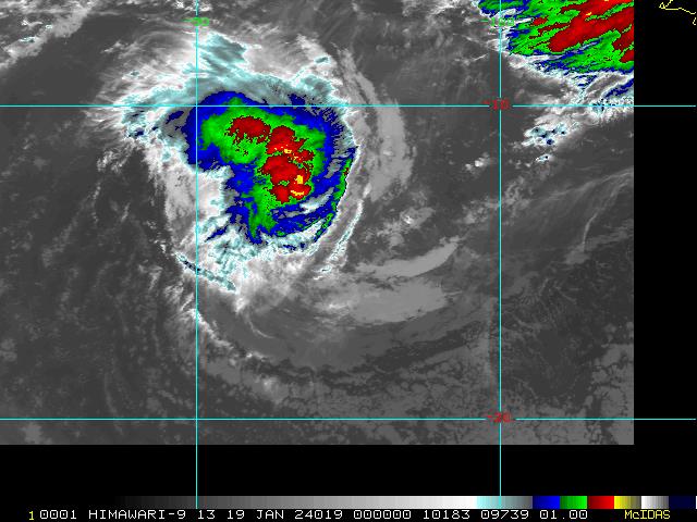
图1 卫星红外监测图像(北京时间2024年01月19日08时00分)
-
IDW27700
TROPICAL CYCLONE TECHNICAL BULLETIN: AUSTRALIA - WESTERN REGION
Issued by AUSTRALIAN BUREAU OF METEOROLOGY TROPICAL CYCLONE WARNING CENTRE
at: 0724 UTC 19/01/2024
Name: Tropical Cyclone Anggrek
Identifier: 04U
Data At: 0600 UTC
Latitude: 12.5S
Longitude: 92.9E
Location Accuracy: within 20nm (35 km)
Movement Towards: west southwest (238 deg)
Speed of Movement: 3 knots (5 km/h)
Maximum 10-Minute Wind: 45 knots (85 km/h)
Maximum 3-Second Wind Gust: 65 knots (120 km/h)
Central Pressure: 993 hPa
Radius of 34-knot winds NE quadrant: 70 nm (130 km)
Radius of 34-knot winds SE quadrant: 70 nm (130 km)
Radius of 34-knot winds SW quadrant: 70 nm (130 km)
Radius of 34-knot winds NW quadrant: 70 nm (130 km)
Radius of 48-knot winds NE quadrant:
Radius of 48-knot winds SE quadrant:
Radius of 48-knot winds SW quadrant:
Radius of 48-knot winds NW quadrant:
Radius of 64-knot winds:  nm ( km)
Radius of Maximum Winds: 30 nm (55 km)
Dvorak Intensity Code: T3.5/3.5/D0.5/24HRS STT:D0.5/06HRS
Pressure of outermost isobar: 1008 hPa
Radius of outermost closed isobar: 180 nm (335 km)
FORECAST DATA
Date/Time    : Location    : Loc. Accuracy: Max Wind   : Central Pressure
(UTC)        : degrees     :      nm  (km): knots(km/h): hPa
+06:  19/1200: 12.6S  92.8E:     035 (060):  045  (085):  993
+12:  19/1800: 12.6S  92.6E:     045 (080):  045  (085):  993
+18:  20/0000: 12.7S  92.4E:     050 (090):  040  (075):  996
+24:  20/0600: 12.7S  92.2E:     050 (095):  040  (075):  996
+36:  20/1800: 12.4S  92.0E:     060 (110):  045  (085):  993
+48:  21/0600: 12.1S  91.8E:     075 (135):  040  (075):  996
+60:  21/1800: 11.9S  91.7E:     090 (165):  035  (065):  999
+72:  22/0600: 11.7S  91.8E:     110 (200):  035  (065):  999
+96:  23/0600: 11.6S  91.8E:     160 (295):  030  (055): 1001
+120: 24/0600: 11.3S  91.6E:     205 (375):  030  (055): 1001
REMARKS:
Tropical Cyclone Anggrek continues moving slowly southwest as a category 1
system.

Position is based on animated EIR imagery with low to medium confidence due to
the LLCC being obscured by deep convection.

With deep convection covering the centre, Anggrek is no longer displaying a
shear pattern, however curvature also remains limited. Applying a curved band
pattern to the EIR gives a wrap of 0.6-0.7 and a DT of 3.0. MET is 4.0 based on
a D development trend and PAT is 3.5. FT/CI 3.5, based on PAT. Current
objective aids are: ADT 53 kn, AiDT 41 kn, DPRINT 64 kn and SATCON 51 kn(all
one-minute means). Intensity set to 45 knots.

SSTs are around 28 degrees C along the forecast track. CIMSS Shear at 0600Z is
relatively high at 23.9 knots easterly despite the lack of a clear shear
presentation on EIR imagery. The system is forecast to fluctuate between 40-45
kn through the weekend and early next week due to competing influences. Due to
the small size, it could still reach category 2 for a period.  Shear is likely
to limit the intensity while strong upper divergence is expected to help it
sustain tropical cyclone intensity. Dry air is also encroaching on the system
but for now it remains in a sufficiently moist environment. An increase in dry
air and shear later in the weekend is likely to cause the system to weaken
below tropical cyclone intensity.  However, there is a moderate percentage of
guidance scenarios which suggest it might move faster to the west and have the
potential to maintain tropical cyclone intensity and strengthen from early next
week.

The movement of the system is also being impacted by competing influences. The
primary factors include mid-level westerlies to the north of the system and a
redeveloping ridge to the south. For now these are reasonably balanced and
hence Anggrek is slow moving. Most guidance suggests that the ridge will begin
to dominate as the steering influence and Anggrek will move westwards. If it
weakens into a shallow system then this would begin to favour eastward movement
in the medium to longer term.

Copyright Commonwealth of Australia
==
The next bulletin for this system will be issued by: 19/1330 UTC.
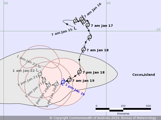
Time (CCT) Intensity Category Latitude
(decimal deg.)Longitude
(decimal deg.)Estimated Position
Accuracy (km)0hr 1 pm January 19 1 12.5S 92.9E 35 +6hr 7 pm January 19 1 12.6S 92.8E 60 +12hr 1 am January 20 1 12.6S 92.6E 80 +18hr 7 am January 20 1 12.7S 92.4E 90 +24hr 1 pm January 20 1 12.7S 92.2E 95 +36hr 1 am January 21 1 12.4S 92.0E 110 +48hr 1 pm January 21 1 12.1S 91.8E 135 +60hr 1 am January 22 tropical low 11.9S 91.7E 165 +72hr 1 pm January 22 tropical low 11.7S 91.8E 200 -
WTXS32 PGTW 190900
MSGID/GENADMIN/JOINT TYPHOON WRNCEN PEARL HARBOR HI//
SUBJ/TROPICAL CYCLONE 06S (ANGGREK) WARNING NR 009//
RMKS/
1. TROPICAL CYCLONE 06S (ANGGREK) WARNING NR 009
   02 ACTIVE TROPICAL CYCLONES IN SOUTHIO
   MAX SUSTAINED WINDS BASED ON ONE-MINUTE AVERAGE
   WIND RADII VALID OVER OPEN WATER ONLY
    ---
   WARNING POSITION:
   190600Z --- NEAR 12.4S 92.9E
     MOVEMENT PAST SIX HOURS - 250 DEGREES AT 03 KTS
     POSITION ACCURATE TO WITHIN 030 NM
     POSITION BASED ON CENTER LOCATED BY SATELLITE
   PRESENT WIND DISTRIBUTION:
   MAX SUSTAINED WINDS - 060 KT, GUSTS 075 KT
   WIND RADII VALID OVER OPEN WATER ONLY
   RADIUS OF 050 KT WINDS - 030 NM NORTHEAST QUADRANT
                            055 NM SOUTHEAST QUADRANT
                            050 NM SOUTHWEST QUADRANT
                            040 NM NORTHWEST QUADRANT
   RADIUS OF 034 KT WINDS - 075 NM NORTHEAST QUADRANT
                            115 NM SOUTHEAST QUADRANT
                            100 NM SOUTHWEST QUADRANT
                            085 NM NORTHWEST QUADRANT
   REPEAT POSIT: 12.4S 92.9E
    ---
   FORECASTS:
   12 HRS, VALID AT:
   191800Z --- 12.6S 92.5E
   MAX SUSTAINED WINDS - 060 KT, GUSTS 075 KT
   WIND RADII VALID OVER OPEN WATER ONLY
   RADIUS OF 050 KT WINDS - 020 NM NORTHEAST QUADRANT
                            050 NM SOUTHEAST QUADRANT
                            050 NM SOUTHWEST QUADRANT
                            040 NM NORTHWEST QUADRANT
   RADIUS OF 034 KT WINDS - 070 NM NORTHEAST QUADRANT
                            090 NM SOUTHEAST QUADRANT
                            070 NM SOUTHWEST QUADRANT
                            080 NM NORTHWEST QUADRANT
   VECTOR TO 24 HR POSIT: 270 DEG/ 02 KTS
    ---
   24 HRS, VALID AT:
   200600Z --- 12.6S 92.1E
   MAX SUSTAINED WINDS - 055 KT, GUSTS 070 KT
   WIND RADII VALID OVER OPEN WATER ONLY
   RADIUS OF 050 KT WINDS - 010 NM NORTHEAST QUADRANT
                            050 NM SOUTHEAST QUADRANT
                            050 NM SOUTHWEST QUADRANT
                            030 NM NORTHWEST QUADRANT
   RADIUS OF 034 KT WINDS - 060 NM NORTHEAST QUADRANT
                            080 NM SOUTHEAST QUADRANT
                            070 NM SOUTHWEST QUADRANT
                            070 NM NORTHWEST QUADRANT
   VECTOR TO 36 HR POSIT: 285 DEG/ 02 KTS
    ---
   36 HRS, VALID AT:
   201800Z --- 12.5S 91.7E
   MAX SUSTAINED WINDS - 055 KT, GUSTS 070 KT
   WIND RADII VALID OVER OPEN WATER ONLY
   RADIUS OF 050 KT WINDS - 010 NM NORTHEAST QUADRANT
                            020 NM SOUTHEAST QUADRANT
                            020 NM SOUTHWEST QUADRANT
                            030 NM NORTHWEST QUADRANT
   RADIUS OF 034 KT WINDS - 060 NM NORTHEAST QUADRANT
                            090 NM SOUTHEAST QUADRANT
                            080 NM SOUTHWEST QUADRANT
                            070 NM NORTHWEST QUADRANT
   VECTOR TO 48 HR POSIT: 305 DEG/ 02 KTS
    ---
   EXTENDED OUTLOOK:
   48 HRS, VALID AT:
   210600Z --- 12.3S 91.4E
   MAX SUSTAINED WINDS - 050 KT, GUSTS 065 KT
   WIND RADII VALID OVER OPEN WATER ONLY
   RADIUS OF 050 KT WINDS - 020 NM NORTHEAST QUADRANT
                            020 NM SOUTHEAST QUADRANT
                            020 NM SOUTHWEST QUADRANT
                            030 NM NORTHWEST QUADRANT
   RADIUS OF 034 KT WINDS - 050 NM NORTHEAST QUADRANT
                            080 NM SOUTHEAST QUADRANT
                            080 NM SOUTHWEST QUADRANT
                            070 NM NORTHWEST QUADRANT
   VECTOR TO 72 HR POSIT: 325 DEG/ 01 KTS
    ---
   72 HRS, VALID AT:
   220600Z --- 12.0S 91.2E
   MAX SUSTAINED WINDS - 050 KT, GUSTS 065 KT
   WIND RADII VALID OVER OPEN WATER ONLY
   RADIUS OF 050 KT WINDS - 020 NM NORTHEAST QUADRANT
                            020 NM SOUTHEAST QUADRANT
                            020 NM SOUTHWEST QUADRANT
                            040 NM NORTHWEST QUADRANT
   RADIUS OF 034 KT WINDS - 050 NM NORTHEAST QUADRANT
                            080 NM SOUTHEAST QUADRANT
                            070 NM SOUTHWEST QUADRANT
                            060 NM NORTHWEST QUADRANT
   VECTOR TO 96 HR POSIT: 360 DEG/ 01 KTS
    ---
   LONG RANGE OUTLOOK:
    ---
   96 HRS, VALID AT:
   230600Z --- 11.7S 91.2E
   MAX SUSTAINED WINDS - 050 KT, GUSTS 065 KT
   WIND RADII VALID OVER OPEN WATER ONLY
   RADIUS OF 050 KT WINDS - 010 NM NORTHEAST QUADRANT
                            010 NM SOUTHEAST QUADRANT
                            020 NM SOUTHWEST QUADRANT
                            020 NM NORTHWEST QUADRANT
   RADIUS OF 034 KT WINDS - 050 NM NORTHEAST QUADRANT
                            070 NM SOUTHEAST QUADRANT
                            060 NM SOUTHWEST QUADRANT
                            060 NM NORTHWEST QUADRANT
   VECTOR TO 120 HR POSIT: 090 DEG/ 01 KTS
    ---
   120 HRS, VALID AT:
   240600Z --- 11.7S 91.5E
   MAX SUSTAINED WINDS - 045 KT, GUSTS 055 KT
   WIND RADII VALID OVER OPEN WATER ONLY
   RADIUS OF 034 KT WINDS - 040 NM NORTHEAST QUADRANT
                            090 NM SOUTHEAST QUADRANT
                            080 NM SOUTHWEST QUADRANT
                            060 NM NORTHWEST QUADRANT
    ---
REMARKS:
190900Z POSITION NEAR 12.5S 92.8E.
19JAN24. TROPICAL CYCLONE 06S (ANGGREK), LOCATED APPROXIMATELY
232 NM WEST OF THE COCOS ISLANDS, HAS TRACKED WEST-
SOUTHWESTWARD AT 03 KNOTS OVER THE PAST SIX HOURS.
MINIMUM CENTRAL PRESSURE AT 190600Z IS 988 MB. MAXIMUM
SIGNIFICANT WAVE HEIGHT AT 190600Z IS 21 FEET. NEXT WARNINGS AT
192100Z AND 200900Z. REFER TO TROPICAL CYCLONE 05S (BELAL)
FINAL WARNING (WTXS31 PGTW).//
NNNN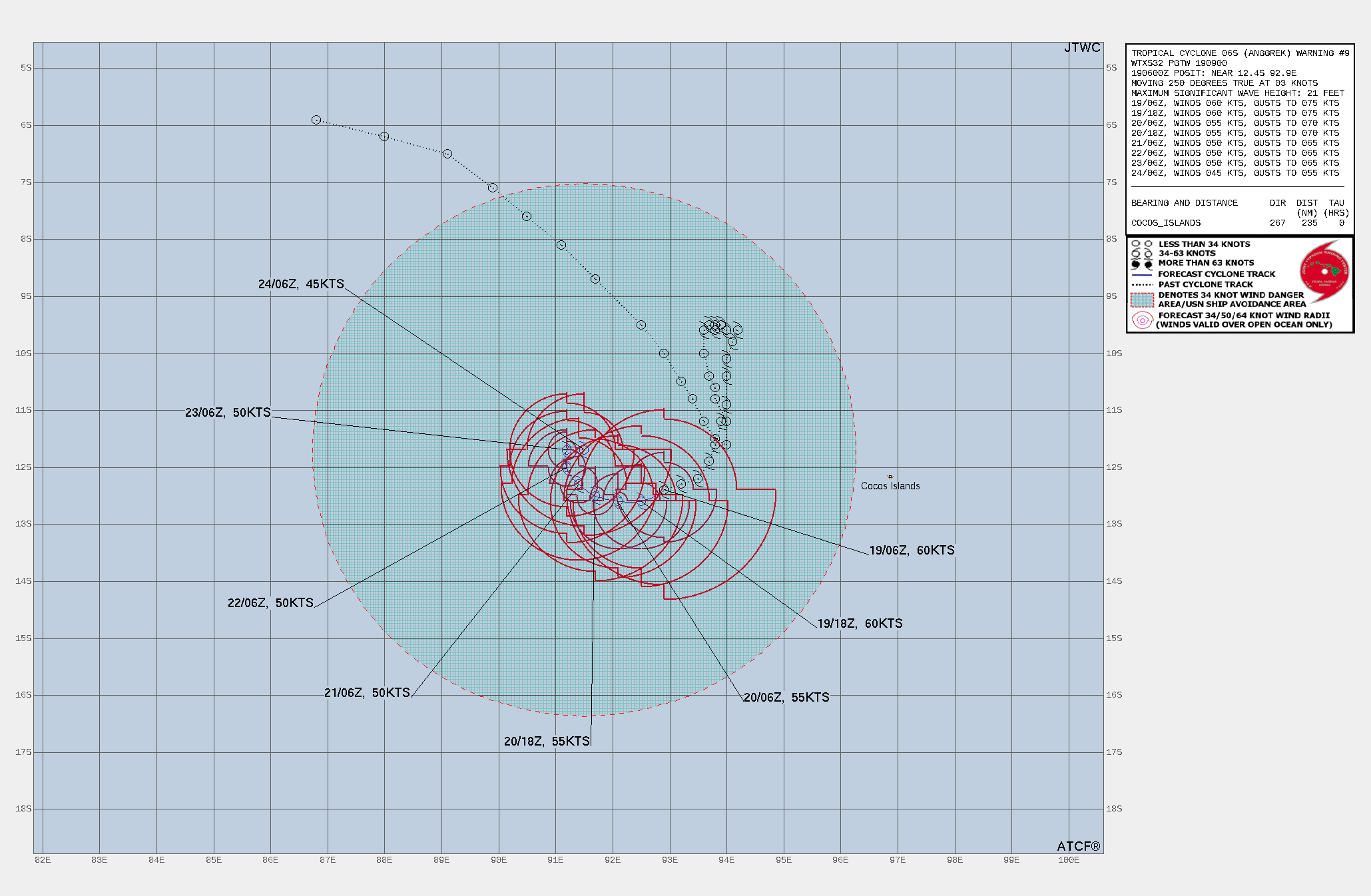
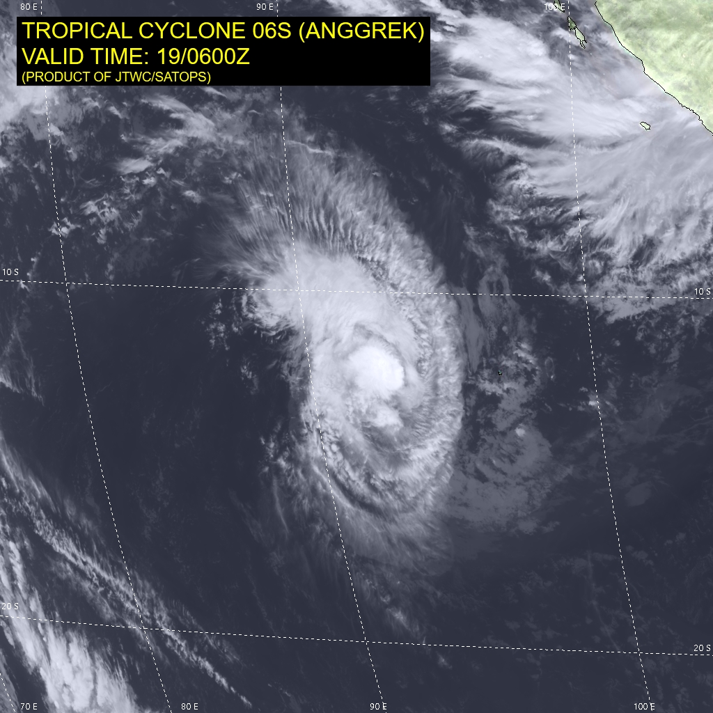
WDXS32 PGTW 190900
MSGID/GENADMIN/JOINT TYPHOON WRNCEN PEARL HARBOR HI//
SUBJ/PROGNOSTIC REASONING FOR TROPICAL CYCLONE 06S (ANGGREK)
WARNING NR 009//
RMKS/
1. FOR METEOROLOGISTS.
2. 6 HOUR SUMMARY AND ANALYSIS.

SUMMARY:
   INITIAL POSITION: 12.4S 92.9E
   INITIAL INTENSITY: 60 KTS
   GEOGRAPHIC REFERENCE: 232 NM WEST OF THE COCOS ISLANDS
   MOVEMENT PAST 6 HOURS: WEST-SOUTHWESTWARD AT 03 KTS
   SIGNIFICANT WAVE HEIGHT: 21 FEET

SATELLITE ANALYSIS, INITIAL POSITION AND INTENSITY DISCUSSION:
DESPITE SOME DRY AIR OVER THE SOUTHERN SEMICIRCLE, WHICH IS HINDERING
CONVECTIVE DEVELOPMENT, THE SYSTEM HAS STRENGTHENED NOTICEABLY OVER
THE PAST 12 HOURS. ANIMATED MULTISPECTRAL SATELLITE IMAGERY (MSI)
DEPICTS DEEP CONVECTIVE BANDING, PRIMARILY IN THE NORTHERN
SEMICIRCLE, WRAPPING INTO A COMPACT CORE, WITH A DEVELOPING EYE. A
190324Z MHS 89 GHZ MICROWAVE IMAGE REVEALS A PARTIAL EYEWALL OVER THE
NORTHERN QUADRANT WITH A WEAKER, FRAGMENTED EYEWALL OVER THE SOUTHERN
QUADRANT. EQUATORWARD OUTFLOW IS ROBUST AS IS EVIDENT ON THE ANIMATED
WATER VAPOR LOOP. THE INITIAL POSITION IS PLACED WITH HIGH CONFIDENCE
BASED ON EXTRAPOLATION FROM A BULLSEYE 190327Z ASCAT-B IMAGE. THE
INITIAL INTENSITY OF 60 KTS IS ASSESSED WITH MEDIUM CONFIDENCE BASED
ON AN AVERAGE OF THE SUBJECTIVE DVORAK ESTIMATES. CIMSS OBJECTIVE
ESTIMATES ARE SLIGHTLY LOWER.

INITIAL WIND RADII BASIS: OBJECTIVE BEST TRACK

CURRENT STEERING MECHANISM: WEAK SUBTROPICAL RIDGE (STR) POSITIONED
TO THE SOUTH.

AGENCY DVORAK AND AUTOMATED FIXES:
   PGTW: T4.0 - 65 KTS
   KNES: T3.5 - 55 KTS
   DEMS: T4.0 - 65 KTS
   APRF: T3.5 - 55 KTS
   CIMSS ADT: 53 KTS AT 190600Z
   CIMSS AIDT: 56 KTS AT 190600Z

FORECASTER ASSESSMENT OF CURRENT ENVIRONMENT: FAVORABLE
   VWS: 10-15 KTS
   SST: 27-28 CELSIUS
   OUTFLOW: STRONG EQUATORWARD
   OTHER FACTORS: DRY AIR ENTRAINMENT OVER THE SOUTHERN SEMICIRCLE

ANALYSIS CONFIDENCE:
   INITIAL POSITION: HIGH
   INITIAL INTENSITY: MEDIUM
   INITIAL WIND RADII: LOW

3. FORECAST REASONING.

SIGNIFICANT FORECAST CHANGES: THERE ARE NO SIGNIFICANT CHANGES TO
THE FORECAST FROM THE PREVIOUS WARNING.

FORECAST DISCUSSION: TROPICAL CYCLONE (TC) 06S IS TRACKING SLOWLY
ALONG THE NORTHERN PERIPHERY OF THE STR AND IS FORECASTED TO TURN
SLOWLY WEST-NORTHWESTWARD AS THE STR REORIENTS AFTER TAU 24. AFTER
TAU 72, THE STEERING ENVIRONMENT BECOMES COMPLEX WITH RIDGING
SURROUNDING THE SYSTEM, CAUSING A VERY SLOW, ERRATIC TRACK IN THE
LATER TAUS. TC 06S WILL MAINTAIN INTENSITY AT 60 KNOTS THROUGH TAU 12
THEN WEAKEN STEADILY THROUGH THE FORECAST PERIOD DUE TO AN INCREASE
IN DRY AIR ENTRAINMENT.

MODEL DISCUSSION: NUMERICAL MODEL GUIDANCE IS IN FAIR AGREEMENT
THROUGH TAU 72 WITH MEDIUM CONFIDENCE IN THE JTWC TRACK FORECAST.
HOWEVER, AFTER TAU 72 BOTH THE ENSEMBLE MODELS (GEFS AND EPS) AND
DETERMINISTIC TRACKERS INDICATE HIGH UNCERTAINTY WITH ERRATIC
QUASI-STATIONARY TRACKS. THE JTWC INTENSITY FORECAST IS SUPPORTED BY
THE HAFS-A AND COAMPS-TC (GFS VERSION) GUIDANCE.

FORECAST CONFIDENCE:
   TRACK 0 - 72 HR: MEDIUM
   TRACK 72-120 HR: LOW
   INTENSITY 0 - 72 HR: MEDIUM
   INTENSITY 72-120 HR: LOW//
NNNN
-
全球热带气旋监测公报
预报:渠鸿宇 签发:高拴柱 2024 年 01 月 19 日 18 时
“安格雷克”向西南方向移动
时 间:19日14时(北京时)
海 域:澳大利亚附近海域
命 名:“安格雷克”,ANGGREK
中心位置:南纬12.5度、东经92.9度
强度等级:一级热带气旋
最大风力:9级(23米/秒,相当于我国的热带风暴级)
中心气压:993百帕
参考位置:科科斯群岛偏西方向约435公里的洋面上
变化过程:过去24小时,“安格雷克”由8级加强到9级
预报结论:“安格雷克”将以每小时5-10公里的速度向西南方向移动,强度逐渐增强。
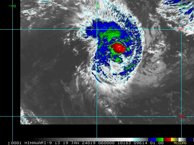
图1 卫星红外监测图像(北京时间2024年01月19日14时00分)
-
IDW27700
TROPICAL CYCLONE TECHNICAL BULLETIN: AUSTRALIA - WESTERN REGION
Issued by AUSTRALIAN BUREAU OF METEOROLOGY TROPICAL CYCLONE WARNING CENTRE
at: 1257 UTC 19/01/2024
Name: Tropical Cyclone Anggrek
Identifier: 04U
Data At: 1200 UTC
Latitude: 12.6S
Longitude: 92.8E
Location Accuracy: within 20nm (35 km)
Movement Towards: west southwest (243 deg)
Speed of Movement: 2 knots (4 km/h)
Maximum 10-Minute Wind: 45 knots (85 km/h)
Maximum 3-Second Wind Gust: 65 knots (120 km/h)
Central Pressure: 993 hPa
Radius of 34-knot winds NE quadrant: 70 nm (130 km)
Radius of 34-knot winds SE quadrant: 70 nm (130 km)
Radius of 34-knot winds SW quadrant: 70 nm (130 km)
Radius of 34-knot winds NW quadrant: 70 nm (130 km)
Radius of 48-knot winds NE quadrant:
Radius of 48-knot winds SE quadrant:
Radius of 48-knot winds SW quadrant:
Radius of 48-knot winds NW quadrant:
Radius of 64-knot winds:  nm ( km)
Radius of Maximum Winds: 30 nm (55 km)
Dvorak Intensity Code: T3.0/3.5/D0.5/24HRS STT:S0.0/6HRS
Pressure of outermost isobar: 1008 hPa
Radius of outermost closed isobar: 220 nm (405 km)
FORECAST DATA
Date/Time    : Location    : Loc. Accuracy: Max Wind   : Central Pressure
(UTC)        : degrees     :      nm  (km): knots(km/h): hPa
+06:  19/1800: 12.6S  92.6E:     035 (065):  045  (085):  993
+12:  20/0000: 12.6S  92.5E:     045 (080):  045  (085):  993
+18:  20/0600: 12.6S  92.2E:     050 (090):  045  (085):  993
+24:  20/1200: 12.5S  92.1E:     055 (100):  045  (085):  993
+36:  21/0000: 12.1S  91.8E:     060 (110):  045  (085):  993
+48:  21/1200: 11.9S  91.6E:     075 (135):  040  (075):  996
+60:  22/0000: 11.8S  91.6E:     095 (175):  035  (065):  998
+72:  22/1200: 11.8S  91.7E:     110 (205):  030  (055): 1001
+96:  23/1200: 11.8S  92.0E:     155 (285):  030  (055): 1001
+120: 24/1200: 11.9S  92.2E:     200 (370):  030  (055): 1001
REMARKS:
Tropical Cyclone Anggrek continues moving slowly west southwest as a category 1
system.

Position is based on two good microwave passes at 07UTC and 0924 UTC and
animated VIS imagery with good confidence.

With deep convection covering the centre, Anggrek is no longer displaying a
shear pattern, however curvature also remains limited. Applying a curved band
pattern to the VIS imagery gives a wrap of about 0.5 and a DT of 2.5. MET is
3.5 based on a D- development trend and PAT is adjusted to 3.0. FT/CI 3.0/3.5,
based on PAT. Current objective aids are: ADT 55 kn, AiDT 46 kn, DMINT 60 kn
(all one-minute means). Intensity set to 45 knots weighted to day time SCAT
passes.

SSTs are around 28 degrees C along the forecast track. CIMSS Shear at 0600Z is
relatively high at 23.9 knots easterly despite the lack of a clear shear
presentation on EIR imagery. In the short term it is likely Anggrek will remain
around 40-45 knots in intensity, in the longer term marginal SSTs, higher shear
and dry air intrusion are expected to weaken the system to below cyclone
strength by Monday. There is a moderate percentage of guidance scenarios which
suggest it might move faster to the west and have the potential to maintain
tropical cyclone intensity and strengthen from early next week.

The movement of the system is also being impacted by competing influences. The
primary factors include mid-level westerlies to the north of the system and a
redeveloping ridge to the south. For now these are reasonably balanced and
hence Anggrek is slow moving. The current forecast track shows the system
performing a loop until it begins a faster movement to the west by next
Thursday. Ensembles show both westwards and eastwards movers and the motion
will be dependent on the intensity of the system, stronger systems are likely
to be steered west and weaker systems to the east.


Copyright Commonwealth of Australia
==
The next bulletin for this system will be issued by: 19/1930 UTC.
Time (CCT) Intensity Category Latitude
(decimal deg.)Longitude
(decimal deg.)Estimated Position
Accuracy (km)0hr 7 pm January 19 1 12.6S 92.8E 35 +6hr 1 am January 20 1 12.6S 92.6E 65 +12hr 7 am January 20 1 12.6S 92.5E 80 +18hr 1 pm January 20 1 12.6S 92.2E 90 +24hr 7 pm January 20 1 12.5S 92.1E 100 +36hr 7 am January 21 1 12.1S 91.8E 110 +48hr 7 pm January 21 1 11.9S 91.6E 135 +60hr 7 am January 22 tropical low 11.8S 91.6E 175 +72hr 7 pm January 22 tropical low 11.8S 91.7E 205