最新回复 (128)
-

IDW27700
TROPICAL CYCLONE TECHNICAL BULLETIN: AUSTRALIA - WESTERN REGION
Issued by AUSTRALIAN BUREAU OF METEOROLOGY TROPICAL CYCLONE WARNING CENTRE
at: 1326 UTC 22/01/2024
Name: Tropical Cyclone Anggrek
Identifier: 04U
Data At: 1200 UTC
Latitude: 12.2S
Longitude: 91.4E
Location Accuracy: within 20nm (35 km)
Movement Towards: southwest (224 deg)
Speed of Movement: 1 knots (3 km/h)
Maximum 10-Minute Wind: 35 knots (65 km/h)
Maximum 3-Second Wind Gust: 50 knots (95 km/h)
Central Pressure: 999 hPa
Radius of 34-knot winds NE quadrant: 70 nm (130 km)
Radius of 34-knot winds SE quadrant: 60 nm (110 km)
Radius of 34-knot winds SW quadrant: 60 nm (110 km)
Radius of 34-knot winds NW quadrant: 70 nm (130 km)
Radius of 48-knot winds NE quadrant:
Radius of 48-knot winds SE quadrant:
Radius of 48-knot winds SW quadrant:
Radius of 48-knot winds NW quadrant:
Radius of 64-knot winds:  nm ( km)
Radius of Maximum Winds: 20 nm (35 km)
Dvorak Intensity Code: T3.0/3.0/S0.0/24HRS STT:S0.0/06HRS
Pressure of outermost isobar: 1008 hPa
Radius of outermost closed isobar: 180 nm (335 km)
FORECAST DATA
Date/Time    : Location    : Loc. Accuracy: Max Wind   : Central Pressure
(UTC)        : degrees     :      nm  (km): knots(km/h): hPa
+06:  22/1800: 12.3S  91.2E:     035 (060):  040  (075):  996
+12:  23/0000: 12.5S  91.0E:     040 (075):  045  (085):  993
+18:  23/0600: 12.7S  90.8E:     045 (085):  050  (095):  990
+24:  23/1200: 12.9S  90.6E:     050 (090):  055  (100):  987
+36:  24/0000: 13.2S  90.2E:     055 (100):  070  (130):  975
+48:  24/1200: 13.6S  89.8E:     075 (140):  075  (140):  971
+60:  25/0000: 14.1S  89.2E:     095 (175):  075  (140):  972
+72:  25/1200: 14.9S  88.1E:     115 (210):  070  (130):  977
+96:  26/1200: 17.4S  84.4E:     160 (300):  060  (110):  986
+120: 27/1200: 19.8S  80.2E:     230 (425):  055  (100):  987
REMARKS:
Tropical Cyclone Anggrek is expected to restrengthen as environmental
conditions begin to improve.

Position is based on animated visible satellite imagery and a 0930Z GMI 37 GHz
microwave image. Confidence in the position is good. The GMI image showed a
band of deep convection wrapping around the western and northern sides of the
TC. Likewise, satellite imagery in the last 3 hours has shown discontinuous
convective bands with relatively warm cloud tops wrapping around the low level
centre.

Dvorak DT is 2.5-3.0 based on a curved band of 0.5-0.6. MET is 3.0 based on a S
trend with no adjustment to PAT. FT and CI are 3.0 based on MET. Objective aids
have trended higher in recent hours. The latest objective aids are: ADT 51
knots, AiDT 43 knots, DPRINT 48 knots, DMINT 39 knots (all one-minute means).
Intensity is maintained at 35 knots (10-min mean) given there has been no
significant improvement in satellite features of the tropical cyclone.

Tropical Cyclone Anggrek has been impacted by easterly wind shear and dry air.
However the latest CIMSS wind shear estimate has reduced to 14 knots at 1200Z
and is an indication that environmental conditions are beginning to improve.
The combination of SSTs around 28 degrees C, increasing outflow due to an upper
trough west of the system, decreasing wind shear and an inflow of mid-level
moisture from the north should enable Anggrek to restrengthen. This
intensification phase is supported by the majority of numerical models. The
position of the upper trough is particularly supportive on Wednesday and
Thursday, and the forecast is for Anggrek to intensify into a severe tropical
cyclone (category 3).

The slow westward movement of the system is due to a weak mid-latitude ridge to
the south. The ridge strengthens to the southeast of the system from Wednesday
and accelerates Anggrek towards the southwest. The system is forecast to move
outside the Australian area of responsibility between 1800Z 23 January and
1800Z 24 January.

Copyright Commonwealth of Australia
==
The next bulletin for this system will be issued by: 22/1930 UTC.
Time (AWST) Intensity Category Latitude
(decimal deg.)Longitude
(decimal deg.)Estimated Position
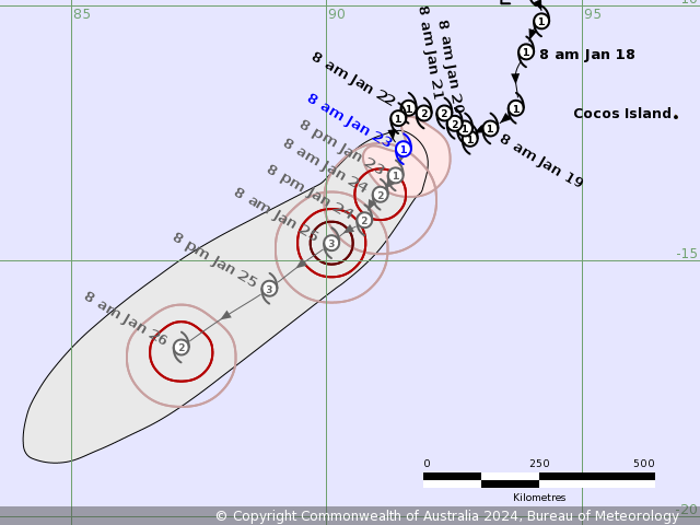
Accuracy (km)0hr 8 pm January 22 1 12.2S 91.4E 35 +6hr 2 am January 23 1 12.3S 91.2E 60 +12hr 8 am January 23 1 12.5S 91.0E 75 +18hr 2 pm January 23 2 12.7S 90.8E 85 +24hr 8 pm January 23 2 12.9S 90.6E 90 +36hr 8 am January 24 3 13.2S 90.2E 100 +48hr 8 pm January 24 3 13.6S 89.8E 140 +60hr 8 am January 25 3 14.1S 89.2E 175 +72hr 8 pm January 25 3 14.9S 88.1E 210 最后于 2024-01-22 21:30:00 被ygsj24编辑 ,原因: -
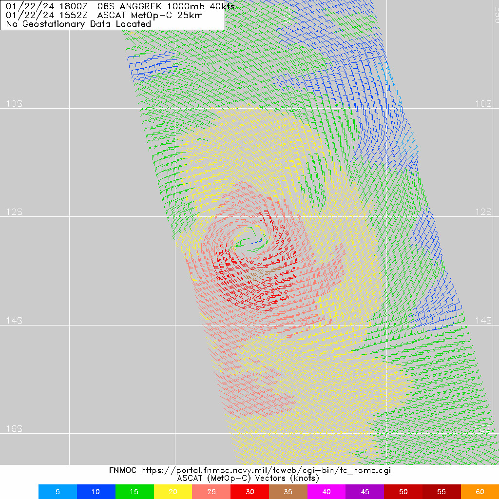
IDW27700
TROPICAL CYCLONE TECHNICAL BULLETIN: AUSTRALIA - WESTERN REGION
Issued by AUSTRALIAN BUREAU OF METEOROLOGY TROPICAL CYCLONE WARNING CENTRE
at: 1933 UTC 22/01/2024
Name: Tropical Cyclone Anggrek
Identifier: 04U
Data At: 1800 UTC
Latitude: 12.6S
Longitude: 91.3E
Location Accuracy: within 20nm (35 km)
Movement Towards: south southwest (198 deg)
Speed of Movement: 3 knots (6 km/h)
Maximum 10-Minute Wind: 35 knots (65 km/h)
Maximum 3-Second Wind Gust: 50 knots (95 km/h)
Central Pressure: 1001 hPa
Radius of 34-knot winds NE quadrant: 40 nm (75 km)
Radius of 34-knot winds SE quadrant: 60 nm (110 km)
Radius of 34-knot winds SW quadrant: 50 nm (95 km)
Radius of 34-knot winds NW quadrant:
Radius of 48-knot winds NE quadrant:
Radius of 48-knot winds SE quadrant:
Radius of 48-knot winds SW quadrant:
Radius of 48-knot winds NW quadrant:
Radius of 64-knot winds:  nm ( km)
Radius of Maximum Winds: 25 nm (45 km)
Dvorak Intensity Code: T2.5/3.0/S0.0/24HRS STT:W0.5/06HRS
Pressure of outermost isobar: 1010 hPa
Radius of outermost closed isobar: 150 nm (280 km)
FORECAST DATA
Date/Time    : Location    : Loc. Accuracy: Max Wind   : Central Pressure
(UTC)        : degrees     :      nm  (km): knots(km/h): hPa
+06:  23/0000: 12.8S  91.1E:     035 (060):  035  (065): 1001
+12:  23/0600: 13.0S  90.9E:     040 (075):  040  (075):  999
+18:  23/1200: 13.2S  90.7E:     045 (085):  045  (085):  995
+24:  23/1800: 13.3S  90.5E:     050 (095):  050  (095):  992
+36:  24/0600: 13.7S  90.1E:     060 (110):  065  (120):  981
+48:  24/1800: 14.1S  89.7E:     080 (145):  075  (140):  973
+60:  25/0600: 14.7S  88.8E:     095 (180):  075  (140):  972
+72:  25/1800: 15.7S  87.4E:     120 (220):  070  (130):  977
+96:  26/1800: 18.3S  83.5E:     170 (320):  060  (110):  984
+120: 27/1800: 20.6S  79.1E:     240 (445):  050  (095):  990
REMARKS:
Tropical Cyclone Anggrek has struggled to maintain intensity overnight.

Position is based on animated satellite imagery and a 1552 ASCAT-C
scatterometer pass. Confidence in the position is good. Satellite imagery in
the last 6 hours has maintained the trend of discontinuous convective bands
with relatively warm cloud tops wrapping around the low level centre. The
recent ASCAT-C pass revealed a system with 25-30 knots around the low level
centre with a small area of 35 knots in the southern semi-circle.

Dvorak DT is 2.5 based on a curved band of 0.5. MET is 3.0 based on a D- trend
with no adjustment to PAT. FT is 2.5 based on DT and CI is held at due to
weakening trend. The latest objective aids are: ADT 51 knots, AiDT 42 knots,
DPRINT 42 knots (all one-minute means). Intensity is maintained at 35 knots
(10-min mean).

Easterly wind shear has reduced from 18 knots at 0600Z to 10 knots at 1800Z and
has allowed Anggrek to become more symmetrical in its cloud features. However
the deep convection has been relatively weak and as a result Anggrek has
struggled to maintain tropical cyclone intensity overnight. The forecast
environment though is favourable for further development, with SSTs around 28
degrees C along the forecast track, increasing outflow due to an upper trough
west of the system, further easing of wind shear and an inflow of mid-level
moisture from the north. This intensification phase is supported by the
majority of numerical models. The position of the upper trough is particularly
supportive on Wednesday and Thursday and the forecast is for Anggrek to
intensify into a severe tropical cyclone (category 3).

The current south-southwest motion is due to Anggrek being caught in a weakness
between a mid-level ridge over the eastern Indian Ocean and another over the
western Indian Ocean. During the next few days the high associated with the
ridge over the western Indian Ocean will strengthen to the southeast of Anggrek
and accelerate it towards the southwest. Anggrek is forecast to move outside
the Australian area of responsibility between 1800Z 23 January and 1800Z 24
January.

Copyright Commonwealth of Australia
==
The next bulletin for this system will be issued by: 23/0130 UTC.
Time (AWST) Intensity Category Latitude
(decimal deg.)Longitude
(decimal deg.)Estimated Position
Accuracy (km)0hr 2 am January 23 1 12.6S 91.3E 35 +6hr 8 am January 23 1 12.8S 91.1E 60 +12hr 2 pm January 23 1 13.0S 90.9E 75 +18hr 8 pm January 23 1 13.2S 90.7E 85 +24hr 2 am January 24 2 13.3S 90.5E 95 +36hr 2 pm January 24 3 13.7S 90.1E 110 +48hr 2 am January 25 3 14.1S 89.7E 145 +60hr 2 pm January 25 3 14.7S 88.8E 180 +72hr 2 am January 26 3 15.7S 87.4E 220 -
WTXS32 PGTW 222100
MSGID/GENADMIN/JOINT TYPHOON WRNCEN PEARL HARBOR HI//
SUBJ/TROPICAL CYCLONE 06S (ANGGREK) WARNING NR 016//
RMKS/
1. TROPICAL CYCLONE 06S (ANGGREK) WARNING NR 016
   01 ACTIVE TROPICAL CYCLONE IN SOUTHIO
   MAX SUSTAINED WINDS BASED ON ONE-MINUTE AVERAGE
   WIND RADII VALID OVER OPEN WATER ONLY
    ---
   WARNING POSITION:
   221800Z --- NEAR 12.6S 91.4E
     MOVEMENT PAST SIX HOURS - 245 DEGREES AT 02 KTS
     POSITION ACCURATE TO WITHIN 060 NM
     POSITION BASED ON CENTER LOCATED BY SATELLITE
   PRESENT WIND DISTRIBUTION:
   MAX SUSTAINED WINDS - 040 KT, GUSTS 050 KT
   WIND RADII VALID OVER OPEN WATER ONLY
   RADIUS OF 034 KT WINDS - 050 NM NORTHEAST QUADRANT
                            060 NM SOUTHEAST QUADRANT
                            050 NM SOUTHWEST QUADRANT
                            030 NM NORTHWEST QUADRANT
   REPEAT POSIT: 12.6S 91.4E
    ---
   FORECASTS:
   12 HRS, VALID AT:
   230600Z --- 13.0S 91.2E
   MAX SUSTAINED WINDS - 050 KT, GUSTS 065 KT
   WIND RADII VALID OVER OPEN WATER ONLY
   RADIUS OF 050 KT WINDS - 020 NM NORTHEAST QUADRANT
                            020 NM SOUTHEAST QUADRANT
                            030 NM SOUTHWEST QUADRANT
                            020 NM NORTHWEST QUADRANT
   RADIUS OF 034 KT WINDS - 060 NM NORTHEAST QUADRANT
                            070 NM SOUTHEAST QUADRANT
                            060 NM SOUTHWEST QUADRANT
                            050 NM NORTHWEST QUADRANT
   VECTOR TO 24 HR POSIT: 215 DEG/ 02 KTS
    ---
   24 HRS, VALID AT:
   231800Z --- 13.4S 90.9E
   MAX SUSTAINED WINDS - 060 KT, GUSTS 075 KT
   WIND RADII VALID OVER OPEN WATER ONLY
   RADIUS OF 050 KT WINDS - 030 NM NORTHEAST QUADRANT
                            030 NM SOUTHEAST QUADRANT
                            030 NM SOUTHWEST QUADRANT
                            030 NM NORTHWEST QUADRANT
   RADIUS OF 034 KT WINDS - 060 NM NORTHEAST QUADRANT
                            070 NM SOUTHEAST QUADRANT
                            060 NM SOUTHWEST QUADRANT
                            040 NM NORTHWEST QUADRANT
   VECTOR TO 36 HR POSIT: 210 DEG/ 03 KTS
    ---
   36 HRS, VALID AT:
   240600Z --- 13.9S 90.6E
   MAX SUSTAINED WINDS - 075 KT, GUSTS 090 KT
   WIND RADII VALID OVER OPEN WATER ONLY
   RADIUS OF 064 KT WINDS - 020 NM NORTHEAST QUADRANT
                            020 NM SOUTHEAST QUADRANT
                            020 NM SOUTHWEST QUADRANT
                            020 NM NORTHWEST QUADRANT
   RADIUS OF 050 KT WINDS - 030 NM NORTHEAST QUADRANT
                            040 NM SOUTHEAST QUADRANT
                            040 NM SOUTHWEST QUADRANT
                            030 NM NORTHWEST QUADRANT
   RADIUS OF 034 KT WINDS - 060 NM NORTHEAST QUADRANT
                            080 NM SOUTHEAST QUADRANT
                            070 NM SOUTHWEST QUADRANT
                            040 NM NORTHWEST QUADRANT
   VECTOR TO 48 HR POSIT: 220 DEG/ 03 KTS
    ---
   EXTENDED OUTLOOK:
   48 HRS, VALID AT:
   241800Z --- 14.4S 90.2E
   MAX SUSTAINED WINDS - 085 KT, GUSTS 105 KT
   WIND RADII VALID OVER OPEN WATER ONLY
   RADIUS OF 064 KT WINDS - 000 NM NORTHEAST QUADRANT
                            020 NM SOUTHEAST QUADRANT
                            030 NM SOUTHWEST QUADRANT
                            020 NM NORTHWEST QUADRANT
   RADIUS OF 050 KT WINDS - 030 NM NORTHEAST QUADRANT
                            040 NM SOUTHEAST QUADRANT
                            040 NM SOUTHWEST QUADRANT
                            030 NM NORTHWEST QUADRANT
   RADIUS OF 034 KT WINDS - 060 NM NORTHEAST QUADRANT
                            080 NM SOUTHEAST QUADRANT
                            070 NM SOUTHWEST QUADRANT
                            040 NM NORTHWEST QUADRANT
   VECTOR TO 72 HR POSIT: 235 DEG/ 08 KTS
    ---
   72 HRS, VALID AT:
   251800Z --- 16.3S 87.6E
   MAX SUSTAINED WINDS - 070 KT, GUSTS 085 KT
   WIND RADII VALID OVER OPEN WATER ONLY
   RADIUS OF 064 KT WINDS - 010 NM NORTHEAST QUADRANT
                            030 NM SOUTHEAST QUADRANT
                            020 NM SOUTHWEST QUADRANT
                            000 NM NORTHWEST QUADRANT
   RADIUS OF 050 KT WINDS - 030 NM NORTHEAST QUADRANT
                            040 NM SOUTHEAST QUADRANT
                            030 NM SOUTHWEST QUADRANT
                            000 NM NORTHWEST QUADRANT
   RADIUS OF 034 KT WINDS - 050 NM NORTHEAST QUADRANT
                            090 NM SOUTHEAST QUADRANT
                            070 NM SOUTHWEST QUADRANT
                            030 NM NORTHWEST QUADRANT
   VECTOR TO 96 HR POSIT: 235 DEG/ 11 KTS
    ---
   LONG RANGE OUTLOOK:
    ---
   96 HRS, VALID AT:
   261800Z --- 18.8S 83.9E
   MAX SUSTAINED WINDS - 065 KT, GUSTS 080 KT
   WIND RADII VALID OVER OPEN WATER ONLY
   RADIUS OF 064 KT WINDS - 010 NM NORTHEAST QUADRANT
                            010 NM SOUTHEAST QUADRANT
                            010 NM SOUTHWEST QUADRANT
                            010 NM NORTHWEST QUADRANT
   RADIUS OF 050 KT WINDS - 020 NM NORTHEAST QUADRANT
                            030 NM SOUTHEAST QUADRANT
                            030 NM SOUTHWEST QUADRANT
                            020 NM NORTHWEST QUADRANT
   RADIUS OF 034 KT WINDS - 050 NM NORTHEAST QUADRANT
                            070 NM SOUTHEAST QUADRANT
                            060 NM SOUTHWEST QUADRANT
                            030 NM NORTHWEST QUADRANT
   VECTOR TO 120 HR POSIT: 245 DEG/ 11 KTS
    ---
   120 HRS, VALID AT:
   271800Z --- 20.7S 79.6E
   MAX SUSTAINED WINDS - 060 KT, GUSTS 075 KT
   WIND RADII VALID OVER OPEN WATER ONLY
   RADIUS OF 050 KT WINDS - 020 NM NORTHEAST QUADRANT
                            030 NM SOUTHEAST QUADRANT
                            030 NM SOUTHWEST QUADRANT
                            020 NM NORTHWEST QUADRANT
   RADIUS OF 034 KT WINDS - 060 NM NORTHEAST QUADRANT
                            080 NM SOUTHEAST QUADRANT
                            070 NM SOUTHWEST QUADRANT
                            040 NM NORTHWEST QUADRANT
    ---
REMARKS:
222100Z POSITION NEAR 12.7S 91.3E.
22JAN24. TROPICAL CYCLONE 06S (ANGGREK), LOCATED APPROXIMATELY
320 NM WEST OF COCOS ISLANDS, HAS TRACKED WEST-
SOUTHWESTWARD AT 02 KNOTS OVER THE PAST SIX HOURS.
MINIMUM CENTRAL PRESSURE AT 221800Z IS 1000 MB. MAXIMUM
SIGNIFICANT WAVE HEIGHT AT 221800Z IS 20 FEET. NEXT WARNINGS AT
230900Z AND 232100Z.//
NNNN
WDXS32 PGTW 222100
MSGID/GENADMIN/JOINT TYPHOON WRNCEN PEARL HARBOR HI//
SUBJ/PROGNOSTIC REASONING FOR TROPICAL CYCLONE 06S (ANGGREK) WARNING
NR 016//
RMKS/
1. FOR METEOROLOGISTS.
2. 6 HOUR SUMMARY AND ANALYSIS.

SUMMARY:
   INITIAL POSITION: 12.6S 91.4E
   INITIAL INTENSITY: 40 KTS
   GEOGRAPHIC REFERENCE: 1164 NM EAST-SOUTHEAST OF DIEGO GARCIA
   MOVEMENT PAST 6 HOURS: WEST-SOUTHWESTWARD AT 02 KTS
   SIGNIFICANT WAVE HEIGHT: 20 FEET

SATELLITE ANALYSIS, INITIAL POSITION AND INTENSITY DISCUSSION:
ANIMATED MULTISPECTRAL SATELLITE IMAGERY (MSI) SHOWS TROPICAL
CYLONE ANGREK IS STRUGGLING. THE CONVECTIVE BANDS ARE BECOMING
FURTHER SEPARATED DUE TO DRY AIR ENTRAINEMENT AND CONVECTION HAS
SHARPLY WANED OVER THE SOUTHERN HALF OF THE SYSTEM. UPWELLING AS A
RESULT OF THE SLOW MOVEMENT OF THE SYSTEM IS ALSO WORKING
AGAINST IT. THE JTWC DVORAK ASSESMENT HAS ALSO FALLEN TO 2.0/3.0 AT
FIX TIME. THE POSITION AND INTENSITY  ASSESSMENTS ARE BASED PRIMARILY
ON THE A 221552Z ASCAT PASS. ANIMATED WATER VAPOR IMAGERY SHOWS
SUBSTANTIAL SUPPRESSION OF OUTFLOW OVER THE WESTERN AND SOUTHERN
QUADRANTS AND DECENT OUTFLOW OVER THE NORTHEAST QUADRANT. ALONG TRACK
SEA SURFACE TEMPERATURES ARE FAVORABLE FOR A NEW SURGE IN DEVELOPMENT
SHOULD THE SYSTEM MANAGE TO GET MOVING.

INITIAL WIND RADII BASIS: SCATTEROMETER DATA FROM A 221552Z ASCAT.

CURRENT STEERING MECHANISM: THE SYSTEM IS BOBBLING IN A WEAK
STEERING ENVIRONMENT IN A COL BETWEEN THE NEAR EQUATORIAL RIDGE AND
THE SUBTROPICAL RIDGE.

AGENCY DVORAK AND AUTOMATED FIXES:
   PGTW: T3.0 - 45 KTS
   KNES: T3.5 - 55 KTS
   DEMS: T3.0 - 45 KTS
   APRF: T3.0 - 45 KTS
   CIMSS ADT: 51 KTS AT 221730Z

FORECASTER ASSESSMENT OF CURRENT ENVIRONMENT: UNFAVORABLE
   VWS: 5-10 KTS
   SST: 27-28 CELSIUS
   OUTFLOW: WEAK EQUATORWARD

ANALYSIS CONFIDENCE:
   INITIAL POSITION: MEDIUM
   INITIAL INTENSITY: MEDIUM
   INITIAL WIND RADII: MEDIUM

3. FORECAST REASONING.

SIGNIFICANT FORECAST CHANGES: THERE ARE NO SIGNIFICANT CHANGES TO
THE FORECAST FROM THE PREVIOUS WARNING.

FORECAST DISCUSSION: TROPICAL CYCLONE ANGREK WILL DRIFT VERY SLOWLY
ALONG A SOUTHWESTERLY BEARING OVER THE NEXT TWO DAYS AND STEADILY
INTENSIFY IN A LOW SHEAR ENVIRONMENT. AFTER 241800Z THE SUBTROPICAL
RIDGE WILL RETRACT, ALLOWING THE SYSTEM TO MOVE POLEWARD MORE
RAPIDLY THUS EASING THE CONSTRAINT OF UPWELLING. THE SYSTEM IS
EXPECTED TO PEAK IN INTENSITY NEAR THAT TIME BEFORE PLUNGING OCEAN
HEAT CONTENT AND DRY AIR ENTRAINMENT WEAKEN THE SYSTEM.  IT IS STILL
EXPECTED TO MAINTAIN TYPHOON STRENGTH UNTIL THE VERY END OF THE
FORECAST PERIOD.

MODEL DISCUSSION: TRACK GUIDANCE IS UNANIMOUS ON THE SLOW
SOUTHWESTERLY TRACK THROUGH THE FIRST 48 HOURS, THEN THE ALONG
TRACK SPREAD INCREASES AS THE SYSTEM ENCOUNTERS THE SEASONAL
SOUTHEASTERLIES AND GETS SHOVED BACK TOWARDS THE EQUATOR. THE JTWC
FORECAST STAYS NEAR CONSENSUS WITH SLIGHT FAVOR SHOWN TOWARD THE
ECMWF ENSEMBLE. THE INTENSITY GUIDANCE IS GROUND IN THE STATISTICAL
DYNAMICAL (SHIPS) GUIDANCE BUT GOES SHARLY ABOVE THAT DURING THE 36
THROUGH 60 HOUR PERIOD DUE TO INPUT FROM THE HAFS-A COUPLED MODEL.

FORECAST CONFIDENCE:
   TRACK 0 - 72 HR: MEDIUM
   TRACK 72-120 HR: MEDIUM
   INTENSITY 0 - 72 HR: MEDIUM
   INTENSITY 72-120 HR: MEDIUM//
NNNN
最后于 2024-01-23 06:00:00 被ygsj24编辑 ,原因: -
IDW27700
TROPICAL CYCLONE TECHNICAL BULLETIN: AUSTRALIA - WESTERN REGION
Issued by AUSTRALIAN BUREAU OF METEOROLOGY TROPICAL CYCLONE WARNING CENTRE
at: 0120 UTC 23/01/2024
Name: Tropical Cyclone Anggrek
Identifier: 04U
Data At: 0000 UTC
Latitude: 12.8S
Longitude: 91.5E
Location Accuracy: within 20nm (35 km)
Movement Towards: south (179 deg)
Speed of Movement: 2 knots (4 km/h)
Maximum 10-Minute Wind: 35 knots (65 km/h)
Maximum 3-Second Wind Gust: 50 knots (95 km/h)
Central Pressure: 1001 hPa
Radius of 34-knot winds NE quadrant: 40 nm (75 km)
Radius of 34-knot winds SE quadrant: 60 nm (110 km)
Radius of 34-knot winds SW quadrant: 50 nm (95 km)
Radius of 34-knot winds NW quadrant:
Radius of 48-knot winds NE quadrant:
Radius of 48-knot winds SE quadrant:
Radius of 48-knot winds SW quadrant:
Radius of 48-knot winds NW quadrant:
Radius of 64-knot winds:  nm ( km)
Radius of Maximum Winds: 25 nm (45 km)
Dvorak Intensity Code: T2.5/3/0/S0.0/24HRS STT:S0.0/6HRS
Pressure of outermost isobar: 1010 hPa
Radius of outermost closed isobar: 180 nm (335 km)
FORECAST DATA
Date/Time    : Location    : Loc. Accuracy: Max Wind   : Central Pressure
(UTC)        : degrees     :      nm  (km): knots(km/h): hPa
+06:  23/0600: 13.0S  91.4E:     035 (065):  040  (075):  998
+12:  23/1200: 13.3S  91.3E:     045 (080):  045  (085):  995
+18:  23/1800: 13.5S  91.2E:     050 (090):  045  (085):  995
+24:  24/0000: 13.7S  91.0E:     050 (095):  050  (095):  992
+36:  24/1200: 14.2S  90.7E:     060 (115):  060  (110):  985
+48:  25/0000: 14.6S  90.1E:     080 (150):  070  (130):  978
+60:  25/1200: 15.5S  88.9E:     100 (180):  065  (120):  983
+72:  26/0000: 16.7S  87.2E:     115 (210):  055  (100):  991
+96:  27/0000: 19.3S  83.1E:     160 (295):  050  (095):  992
+120: 28/0000: 20.8S  78.7E:     235 (430):  045  (085):  995
REMARKS:
Tropical Cyclone Anggrek has struggled to maintain intensity overnight.

Position is based on 2138 UTC microwave pass and animated IR imagery which
positioned the centre further east than before. Confidence in the position is
good. Satellite imagery in the last 6 hours has maintained the trend of
discontinuous convective bands with relatively warm cloud tops wrapping around
the low level centre. The recent ASCAT-C pass revealed a system with 25-30
knots around the low level centre with a small area of 35 knots in the southern
semi-circle.

Dvorak DT is 2.5 based on a curved band of 0.5. MET is 2.5 based on a S trend
with no adjustment to PAT. FT is 2.5 based on DT and CI is held at due to
weakening trend. The latest objective aids are: ADT 45 knots, AiDT 39 knots,
DPRINT 43 knots (all one-minute means). Intensity is maintained at 35 knots
(10-min mean).

Shear has remained low and Anggrek has symmetrical cloud features. However the
deep convection has been relatively weak and as a result Anggrek has struggled
to maintain tropical cyclone intensity overnight. The forecast environment
though is favourable for further development, with SSTs around 28 degrees C
along the forecast track, increasing outflow due to an upper trough west of the
system, further easing of wind shear and an inflow of mid-level moisture from
the north. This intensification phase is supported by the majority of numerical
models. The position of the upper trough is particularly supportive on
Wednesday and the start of Thursday and the forecast is for Anggrek to
intensify into a severe tropical cyclone (category 3). During Thursday, shear
increases and the system is expected to weaken slowly.

The current slow southward motion is due to Anggrek being caught in a weakness
between a mid-level ridge over the eastern Indian Ocean and another over the
western Indian Ocean. During the next few days the high associated with the
ridge over the western Indian Ocean will strengthen to the southeast of Anggrek
and accelerate it towards the southwest. Anggrek is forecast to move outside
the Australian area of responsibility sometime between 0000Z 24 January and
0000Z 26 January.

Copyright Commonwealth of Australia
==
The next bulletin for this system will be issued by: 23/0730 UTC.
Time (AWST) Intensity Category Latitude
(decimal deg.)Longitude
(decimal deg.)Estimated Position
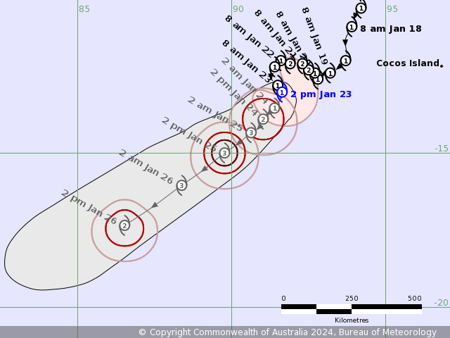
Accuracy (km)0hr 8 am January 23 1 12.8S 91.5E 35 +6hr 2 pm January 23 1 13.0S 91.4E 65 +12hr 8 pm January 23 1 13.3S 91.3E 80 +18hr 2 am January 24 1 13.5S 91.2E 90 +24hr 8 am January 24 2 13.7S 91.0E 95 +36hr 8 pm January 24 2 14.2S 90.7E 115 +48hr 8 am January 25 3 14.6S 90.1E 150 +60hr 8 pm January 25 3 15.5S 88.9E 180 +72hr 8 am January 26 2 16.7S 87.2E 210 最后于 2024-01-23 09:35:00 被ygsj24编辑 ,原因: -
全球热带气旋监测公报
预报:周冠博 签发:董林 2024 年 01 月 23 日 10 时
“安格雷克”将原地少动
时 间:23日08时(北京时)
海 域:澳大利亚附近海域
命 名:“安格雷克”,ANGGREK
中心位置:南纬12.8度、东经91.5度
强度等级:一级热带气旋
最大风力:8级(18米/秒,相当于我国的热带风暴级)
中心气压:1001百帕
参考位置:澳大利亚西澳大利亚州埃克斯茅斯西偏北方向约2600公里的洋面上
变化过程:过去24小时,“安格雷克”强度维持不变
预报结论:“安格雷克”将原地少动,强度逐渐增强。
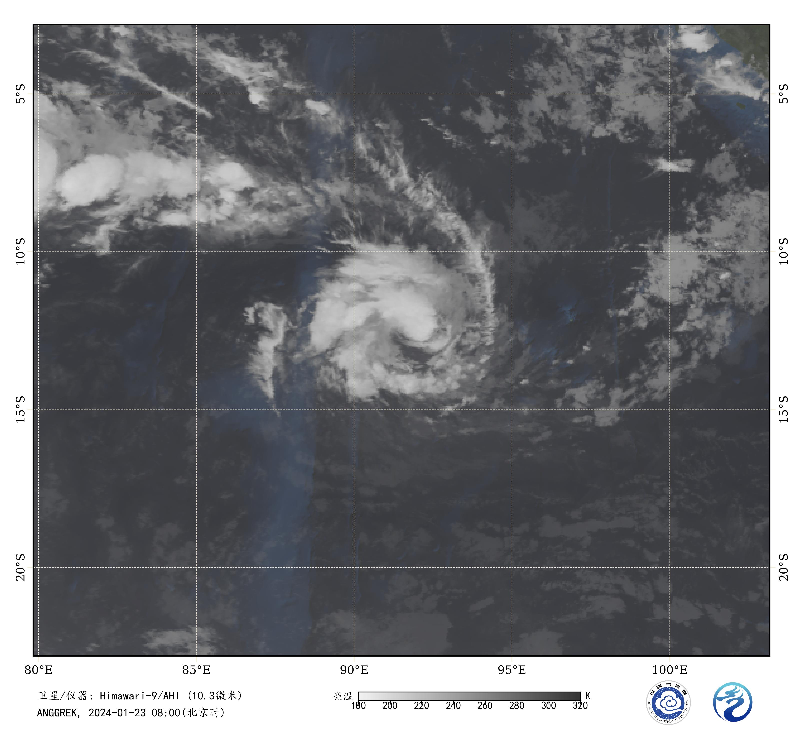
图1 卫星红外监测图像(北京时间2024年01月23日08时00分)
-
IDW27700
TROPICAL CYCLONE TECHNICAL BULLETIN: AUSTRALIA - WESTERN REGION
Issued by AUSTRALIAN BUREAU OF METEOROLOGY TROPICAL CYCLONE WARNING CENTRE
at: 0711 UTC 23/01/2024
Name: Tropical Cyclone Anggrek
Identifier: 04U
Data At: 0600 UTC
Latitude: 13.0S
Longitude: 91.6E
Location Accuracy: within 20nm (35 km)
Movement Towards: south southeast (148 deg)
Speed of Movement: 3 knots (5 km/h)
Maximum 10-Minute Wind: 40 knots (75 km/h)
Maximum 3-Second Wind Gust: 55 knots (100 km/h)
Central Pressure: 998 hPa
Radius of 34-knot winds NE quadrant: 70 nm (130 km)
Radius of 34-knot winds SE quadrant: 70 nm (130 km)
Radius of 34-knot winds SW quadrant: 60 nm (110 km)
Radius of 34-knot winds NW quadrant:
Radius of 48-knot winds NE quadrant:
Radius of 48-knot winds SE quadrant:
Radius of 48-knot winds SW quadrant:
Radius of 48-knot winds NW quadrant:
Radius of 64-knot winds:  nm ( km)
Radius of Maximum Winds: 25 nm (45 km)
Dvorak Intensity Code: T3.0/3.0/S0.0/24HRS STT:D0.5/06HRS
Pressure of outermost isobar: 1010 hPa
Radius of outermost closed isobar: 150 nm (280 km)
FORECAST DATA
Date/Time    : Location    : Loc. Accuracy: Max Wind   : Central Pressure
(UTC)        : degrees     :      nm  (km): knots(km/h): hPa
+06:  23/1200: 13.3S  91.6E:     035 (065):  045  (085):  995
+12:  23/1800: 13.5S  91.4E:     045 (080):  045  (085):  995
+18:  24/0000: 13.7S  91.2E:     050 (090):  050  (095):  992
+24:  24/0600: 13.9S  91.0E:     050 (095):  055  (100):  989
+36:  24/1800: 14.3S  90.6E:     065 (120):  065  (120):  981
+48:  25/0600: 15.0S  89.8E:     085 (155):  070  (130):  979
+60:  25/1800: 16.0S  88.4E:     105 (195):  070  (130):  980
+72:  26/0600: 17.3S  86.5E:     125 (230):  060  (110):  988
+96:  27/0600: 19.7S  82.7E:     185 (345):  050  (095):  992
+120: 28/0600: 21.1S  78.2E:     250 (465):  045  (085):  995
REMARKS:
Tropical Cyclone Anggrek has a slowly improving cloud signature indicating some
strengthening.

Position is based on 0341 UTC microwave pass and animated visible imagery.
Confidence in the position is good. Satellite imagery in the last 6 hours has
shown improved curvature but little increase in the depth of convection. The
recent ASCAT-C pass revealed a system with > 35 knots to the northeast through
to south-southwest of the low level centre.

Dvorak DT is 3.0 based on a curved band of 0.7, but with warm cloud tops. MET
is 2.5 based on a W- trend, PAT adjusted to 3.0. FT is and CI is 3.0 based on
DT and PAT. The latest objective aids are: ADT 45 knots, AiDT 40 knots, DPRINT
44 knots (all one-minute means). Intensity is 40 knots (10-min mean).

Shear is low and Anggrek has fairly symmetrical cloud features. However the
deep convection has been relatively weak and as a result Anggrek is still only
a category 1 system. The forecast environment is favourable for further
development, with SSTs around 28 degrees C along the forecast track, increasing
outflow due to an upper trough west of the system, further easing of wind shear
and an inflow of mid-level moisture from the north. This intensification phase
is supported by the majority of numerical models. The position of the upper
trough is particularly supportive on Wednesday and the start of Thursday and
the forecast is for Anggrek to intensify into a severe tropical cyclone
(category 3). During Thursday, shear increases and the system is expected to
plateau in intensity then start to weaken on Friday. There remains some
ensemble members which continue strengthening during this period.

The current slow southward motion is due to Anggrek being caught in a weakness
between a mid-level ridge over the eastern Indian Ocean and another over the
western Indian Ocean. During the next few days the high associated with the
ridge over the western Indian Ocean will strengthen to the southeast of Anggrek
and accelerate it towards the southwest. Anggrek is forecast to move outside
the Australian area of responsibility sometime between 0000Z 24 January and
0000Z 26 January.

Copyright Commonwealth of Australia
==
The next bulletin for this system will be issued by: 23/1330 UTC.
Time (AWST) Intensity Category Latitude
(decimal deg.)Longitude
(decimal deg.)Estimated Position
Accuracy (km)0hr 2 pm January 23 1 13.0S 91.6E 35 +6hr 8 pm January 23 1 13.3S 91.6E 65 +12hr 2 am January 24 1 13.5S 91.4E 80 +18hr 8 am January 24 2 13.7S 91.2E 90 +24hr 2 pm January 24 2 13.9S 91.0E 95 +36hr 2 am January 25 3 14.3S 90.6E 120 +48hr 2 pm January 25 3 15.0S 89.8E 155 +60hr 2 am January 26 3 16.0S 88.4E 195 +72hr 2 pm January 26 2 17.3S 86.5E 230 -
WTXS32 PGTW 230900
MSGID/GENADMIN/JOINT TYPHOON WRNCEN PEARL HARBOR HI//
SUBJ/TROPICAL CYCLONE 06S (ANGGREK) WARNING NR 017//
RMKS/
1. TROPICAL CYCLONE 06S (ANGGREK) WARNING NR 017
   01 ACTIVE TROPICAL CYCLONE IN SOUTHIO
   MAX SUSTAINED WINDS BASED ON ONE-MINUTE AVERAGE
   WIND RADII VALID OVER OPEN WATER ONLY
    ---
   WARNING POSITION:
   230600Z --- NEAR 13.0S 91.6E
     MOVEMENT PAST SIX HOURS - 180 DEGREES AT 02 KTS
     POSITION ACCURATE TO WITHIN 035 NM
     POSITION BASED ON CENTER LOCATED BY SATELLITE
   PRESENT WIND DISTRIBUTION:
   MAX SUSTAINED WINDS - 040 KT, GUSTS 050 KT
   WIND RADII VALID OVER OPEN WATER ONLY
   RADIUS OF 034 KT WINDS - 050 NM NORTHEAST QUADRANT
                            050 NM SOUTHEAST QUADRANT
                            035 NM SOUTHWEST QUADRANT
                            000 NM NORTHWEST QUADRANT
   REPEAT POSIT: 13.0S 91.6E
    ---
   FORECASTS:
   12 HRS, VALID AT:
   231800Z --- 13.5S 91.5E
   MAX SUSTAINED WINDS - 050 KT, GUSTS 065 KT
   WIND RADII VALID OVER OPEN WATER ONLY
   RADIUS OF 050 KT WINDS - 020 NM NORTHEAST QUADRANT
                            020 NM SOUTHEAST QUADRANT
                            020 NM SOUTHWEST QUADRANT
                            020 NM NORTHWEST QUADRANT
   RADIUS OF 034 KT WINDS - 050 NM NORTHEAST QUADRANT
                            060 NM SOUTHEAST QUADRANT
                            040 NM SOUTHWEST QUADRANT
                            030 NM NORTHWEST QUADRANT
   VECTOR TO 24 HR POSIT: 200 DEG/ 03 KTS
    ---
   24 HRS, VALID AT:
   240600Z --- 14.0S 91.3E
   MAX SUSTAINED WINDS - 060 KT, GUSTS 075 KT
   WIND RADII VALID OVER OPEN WATER ONLY
   RADIUS OF 050 KT WINDS - 030 NM NORTHEAST QUADRANT
                            030 NM SOUTHEAST QUADRANT
                            040 NM SOUTHWEST QUADRANT
                            030 NM NORTHWEST QUADRANT
   RADIUS OF 034 KT WINDS - 050 NM NORTHEAST QUADRANT
                            070 NM SOUTHEAST QUADRANT
                            060 NM SOUTHWEST QUADRANT
                            040 NM NORTHWEST QUADRANT
   VECTOR TO 36 HR POSIT: 220 DEG/ 03 KTS
    ---
   36 HRS, VALID AT:
   241800Z --- 14.5S 90.9E
   MAX SUSTAINED WINDS - 070 KT, GUSTS 085 KT
   WIND RADII VALID OVER OPEN WATER ONLY
   RADIUS OF 064 KT WINDS - 000 NM NORTHEAST QUADRANT
                            000 NM SOUTHEAST QUADRANT
                            020 NM SOUTHWEST QUADRANT
                            020 NM NORTHWEST QUADRANT
   RADIUS OF 050 KT WINDS - 030 NM NORTHEAST QUADRANT
                            030 NM SOUTHEAST QUADRANT
                            030 NM SOUTHWEST QUADRANT
                            030 NM NORTHWEST QUADRANT
   RADIUS OF 034 KT WINDS - 050 NM NORTHEAST QUADRANT
                            080 NM SOUTHEAST QUADRANT
                            060 NM SOUTHWEST QUADRANT
                            040 NM NORTHWEST QUADRANT
   VECTOR TO 48 HR POSIT: 230 DEG/ 06 KTS
    ---
   EXTENDED OUTLOOK:
   48 HRS, VALID AT:
   250600Z --- 15.2S 90.0E
   MAX SUSTAINED WINDS - 075 KT, GUSTS 090 KT
   WIND RADII VALID OVER OPEN WATER ONLY
   RADIUS OF 064 KT WINDS - 000 NM NORTHEAST QUADRANT
                            000 NM SOUTHEAST QUADRANT
                            000 NM SOUTHWEST QUADRANT
                            010 NM NORTHWEST QUADRANT
   RADIUS OF 050 KT WINDS - 030 NM NORTHEAST QUADRANT
                            030 NM SOUTHEAST QUADRANT
                            030 NM SOUTHWEST QUADRANT
                            030 NM NORTHWEST QUADRANT
   RADIUS OF 034 KT WINDS - 050 NM NORTHEAST QUADRANT
                            080 NM SOUTHEAST QUADRANT
                            060 NM SOUTHWEST QUADRANT
                            040 NM NORTHWEST QUADRANT
   VECTOR TO 72 HR POSIT: 235 DEG/ 11 KTS
    ---
   72 HRS, VALID AT:
   260600Z --- 17.8S 86.1E
   MAX SUSTAINED WINDS - 070 KT, GUSTS 085 KT
   WIND RADII VALID OVER OPEN WATER ONLY
   RADIUS OF 064 KT WINDS - 000 NM NORTHEAST QUADRANT
                            000 NM SOUTHEAST QUADRANT
                            000 NM SOUTHWEST QUADRANT
                            010 NM NORTHWEST QUADRANT
   RADIUS OF 050 KT WINDS - 030 NM NORTHEAST QUADRANT
                            030 NM SOUTHEAST QUADRANT
                            030 NM SOUTHWEST QUADRANT
                            030 NM NORTHWEST QUADRANT
   RADIUS OF 034 KT WINDS - 050 NM NORTHEAST QUADRANT
                            080 NM SOUTHEAST QUADRANT
                            060 NM SOUTHWEST QUADRANT
                            040 NM NORTHWEST QUADRANT
   VECTOR TO 96 HR POSIT: 240 DEG/ 11 KTS
    ---
   LONG RANGE OUTLOOK:
    ---
   96 HRS, VALID AT:
   270600Z --- 19.8S 82.1E
   MAX SUSTAINED WINDS - 065 KT, GUSTS 080 KT
   WIND RADII VALID OVER OPEN WATER ONLY
   RADIUS OF 064 KT WINDS - 010 NM NORTHEAST QUADRANT
                            000 NM SOUTHEAST QUADRANT
                            000 NM SOUTHWEST QUADRANT
                            000 NM NORTHWEST QUADRANT
   RADIUS OF 050 KT WINDS - 020 NM NORTHEAST QUADRANT
                            020 NM SOUTHEAST QUADRANT
                            010 NM SOUTHWEST QUADRANT
                            000 NM NORTHWEST QUADRANT
   RADIUS OF 034 KT WINDS - 050 NM NORTHEAST QUADRANT
                            070 NM SOUTHEAST QUADRANT
                            040 NM SOUTHWEST QUADRANT
                            020 NM NORTHWEST QUADRANT
   VECTOR TO 120 HR POSIT: 245 DEG/ 11 KTS
    ---
   120 HRS, VALID AT:
   280600Z --- 21.5S 77.6E
   MAX SUSTAINED WINDS - 065 KT, GUSTS 080 KT
   WIND RADII VALID OVER OPEN WATER ONLY
   RADIUS OF 064 KT WINDS - 000 NM NORTHEAST QUADRANT
                            020 NM SOUTHEAST QUADRANT
                            020 NM SOUTHWEST QUADRANT
                            000 NM NORTHWEST QUADRANT
   RADIUS OF 050 KT WINDS - 020 NM NORTHEAST QUADRANT
                            030 NM SOUTHEAST QUADRANT
                            030 NM SOUTHWEST QUADRANT
                            010 NM NORTHWEST QUADRANT
   RADIUS OF 034 KT WINDS - 050 NM NORTHEAST QUADRANT
                            080 NM SOUTHEAST QUADRANT
                            050 NM SOUTHWEST QUADRANT
                            030 NM NORTHWEST QUADRANT
    ---
REMARKS:
230900Z POSITION NEAR 13.1S 91.6E.
23JAN24. TROPICAL CYCLONE 06S (ANGGREK), LOCATED APPROXIMATELY
1182 NM EAST-SOUTHEAST OF DIEGO GARCIA, HAS TRACKED SOUTHWARD AT
02 KNOTS OVER THE PAST SIX HOURS. MINIMUM CENTRAL PRESSURE AT
230600Z IS 1002 MB. MAXIMUM SIGNIFICANT WAVE HEIGHT AT 230600Z
IS 20 FEET. NEXT WARNINGS AT 232100Z AND 240900Z.//
NNNN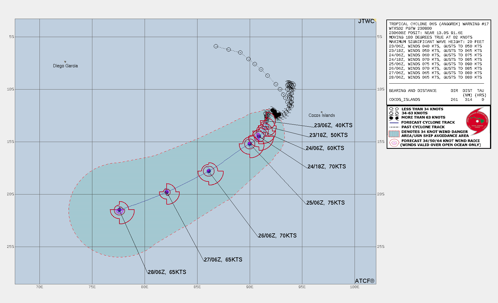
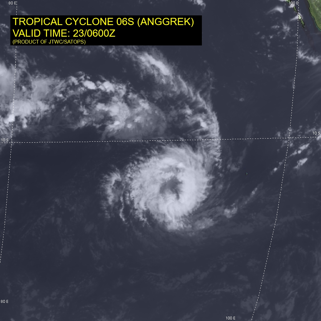

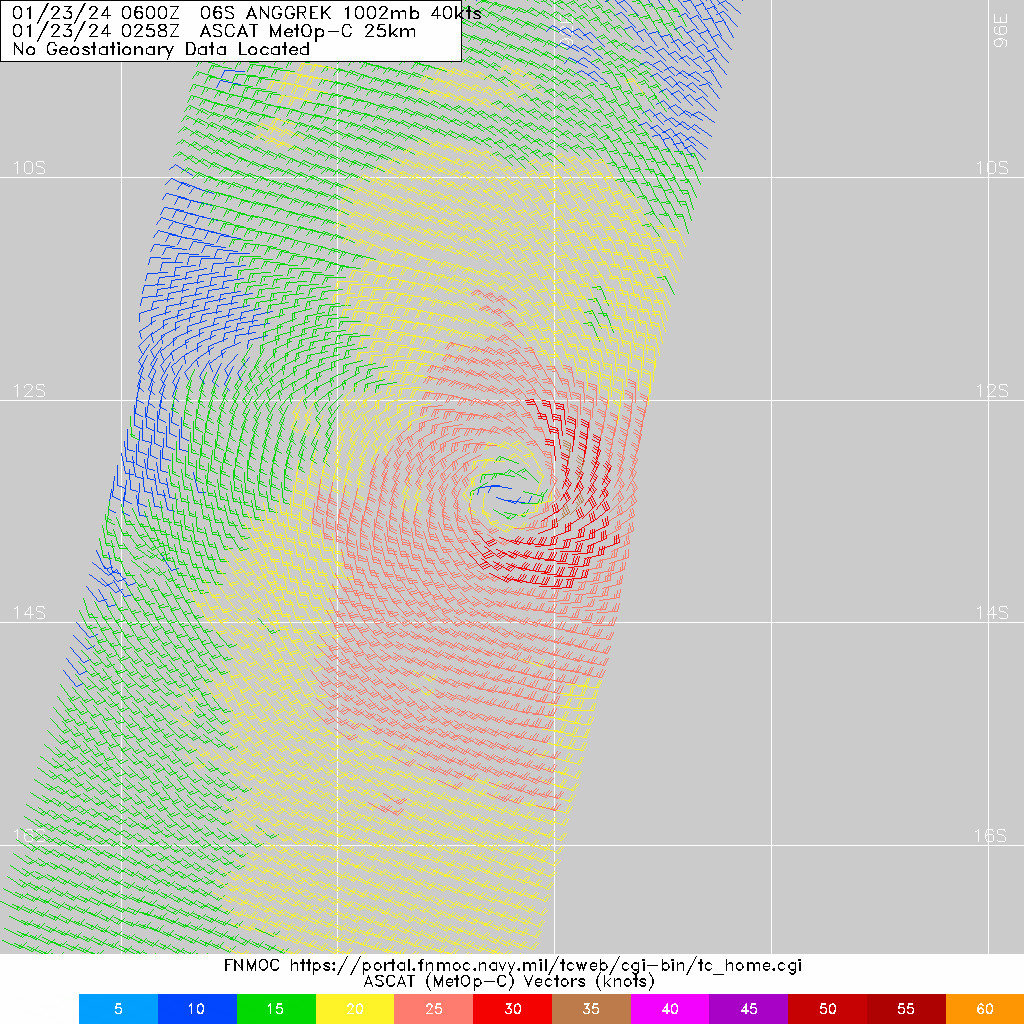
WDXS32 PGTW 230900
MSGID/GENADMIN/JOINT TYPHOON WRNCEN PEARL HARBOR HI//
SUBJ/PROGNOSTIC REASONING FOR TROPICAL CYCLONE 06S (ANGGREK)
WARNING NR 017//
RMKS/
1. FOR METEOROLOGISTS.
2. 6 HOUR SUMMARY AND ANALYSIS.

SUMMARY:
   INITIAL POSITION: 13.0S 91.6E
   INITIAL INTENSITY: 40 KTS
   GEOGRAPHIC REFERENCE: 1182 NM EAST-SOUTHEAST OF DIEGO GARCIA
   MOVEMENT PAST 6 HOURS: SOUTHWARD AT 02 KTS
   SIGNIFICANT WAVE HEIGHT: 20 FEET

SATELLITE ANALYSIS, INITIAL POSITION AND INTENSITY DISCUSSION:
TROPICAL CYCLONE (TC) 06S HAS MAINTAINED INTENSITY AT 40 KNOTS DUE
PRIMARILY TO UPWELLING COOLER WATER RESULTING FROM THE SYSTEM'S
SLOW TRACK MOTION AS REVEALED IN THE RECENT HAFS-A SST ANALYSIS.
ANIMATED ENHANCED INFRARED (EIR) SATELLITE IMAGERY DEPICTS
FRAGMENTED, WEAK DEEP CONVECTIVE BANDING WRAPPING INTO A RAGGED
LOW-LEVEL CIRCULATION CENTER (LLCC), WHICH SUPPORTS THE INITIAL
POSITION WITH HIGH CONFIDENCE. A 230342Z MHS 89 GHZ MICROWAVE IMAGE
SHOWS A 100-110 NM DIAMETER CONVECTION-FREE CORE WITH DEEP
CONVECTIVE BANDS WRAPPED LOOSELY. A 230258Z ASCAT-B BULLSEYE IMAGE
SHOWS A DEFINED CENTER WITH 30-35 KNOT WINDS OVER THE EASTERN
SEMICIRCLE, WHICH SUPPORTS THE INITIAL WIND RADII WITH HIGH
CONFIDENCE. ANIMATED WATER VAPOR IMAGERY AND RECENT CIMSS
UPPER-LEVEL WINDS SHOW AN UPPER-LEVEL TROUGH IMPINGING ON THE
SOUTHERN PERIPHERY OF THE SYSTEM, LIMITING POLEWARD OUTFLOW, WITH
MODERATE EQUATORWARD OUTFLOW. THE INITIAL INTENSITY OF 40 KTS IS
ASSESSED WITH HIGH CONFIDENCE BASED ON RECENT ASCAT DATA AS WELL AS
THE PGTW, DEMS AND APRF SUBJECTIVE DVORAK ESTIMATES.

INITIAL WIND RADII BASIS: SCATTEROMETER DATA

CURRENT STEERING MECHANISM: COMPETING STEERING ENVIRONMENT WITH A
NEAR-EQUATORIAL RIDGE (NER) POSITIONED TO THE NORTH AND A WEAK
SUBTROPICAL RIDGE (STR) POSITIONED TO THE SOUTH.

AGENCY DVORAK AND AUTOMATED FIXES:
   PGTW: T2.5 - 35 KTS
   KNES: T3.5 - 55 KTS
   DEMS: T2.5 - 35 KTS
   APRF: T3.0 - 45 KTS
   CIMSS SATCON: 52 KTS AT 230417Z
   CIMSS ADT: 45 KTS AT 230530Z

FORECASTER ASSESSMENT OF CURRENT ENVIRONMENT: MARGINALLY FAVORABLE
   VWS: 0-5 KTS
   SST: 27-28 CELSIUS
   OUTFLOW: MODERATE EQUATORWARD
   OTHER FACTORS: UPWELLING COOLER WATER

ANALYSIS CONFIDENCE:
   INITIAL POSITION: HIGH
   INITIAL INTENSITY: MEDIUM
   INITIAL WIND RADII: HIGH

3. FORECAST REASONING.

SIGNIFICANT FORECAST CHANGES: THERE ARE NO SIGNIFICANT CHANGES TO
THE FORECAST FROM THE PREVIOUS WARNING.

FORECAST DISCUSSION: TRACK MOTION IS EXPECTED TO REMAIN SLOW AND
POSSIBLY ERRATIC UNTIL AFTER TAU 24 WHEN A DOMINANT STR IS
FORECASTED TO BUILD TO THE SOUTH AND THEN SOUTHEAST, WHICH WILL
ACCELERATE THE SYSTEM WEST-SOUTHWESTWARD THROUGH THE FORECAST
PERIOD. AS THE SYSTEM ACCELERATES, THE LIMITING EFFECTS OF THE
UPWELLING COOLER WATER WILL LESSEN AND THE SYSTEM WILL INTENSIFY AT A
FASTER RATE UP TO A PEAK INTENSITY OF 70-75 KNOTS. AFTER TAU 72,
ENVIRONMENTAL CONDITIONS WILL DEGRADE SLIGHTLY WITH SOME DRY AIR
ENTRAINMENT AND WEAKER OUTFLOW RESULTING IN A SLIGHT WEAKENING TREND.

MODEL DISCUSSION: NUMERICAL MODEL GUIDANCE IS IN GOOD AGREEMENT
THROUGH TAU 72 WITH A 65 NM CROSS-TRACK SPREAD IN SOLUTIONS AT TAU
72 DIVERGING THROUGH TAU 120. THE 230000Z GFS AND ECMWF ENSEMBLES
ALSO SHOW A SIMILAR SPREAD. INTENSITY GUIDANCE REMAINS IN FAIR
AGREEMENT THROUGH THE FORECAST PERIOD, LENDING MEDIUM OVERALL
CONFIDENCE TO THE JTWC INTENSITY FORECAST.

FORECAST CONFIDENCE:
   TRACK 0 - 72 HR: HIGH
   TRACK 72-120 HR: MEDIUM
   INTENSITY 0 - 72 HR: MEDIUM
   INTENSITY 72-120 HR: MEDIUM//
NNNN
最后于 2024-01-23 18:00:00 被ygsj24编辑 ,原因: -
全球热带气旋监测公报
预报:宋佳凝 签发:董林 2024 年 01 月 23 日 18 时
“安格雷克”向西南方向移动
时 间:23日14时(北京时)
海 域:澳大利亚附近海域
命 名:“安格雷克”,ANGGREK
中心位置:南纬13.0度、东经91.6度
强度等级:一级热带气旋
最大风力:8级(20米/秒,相当于我国的热带风暴级)
中心气压:998百帕
参考位置:科科斯群岛偏西方向约580公里的洋面上
变化过程:过去24小时,“安格雷克”强度维持不变
预报结论:“安格雷克”将以每小时5-10公里的速度向西南方向缓慢移动,强度逐渐增强。
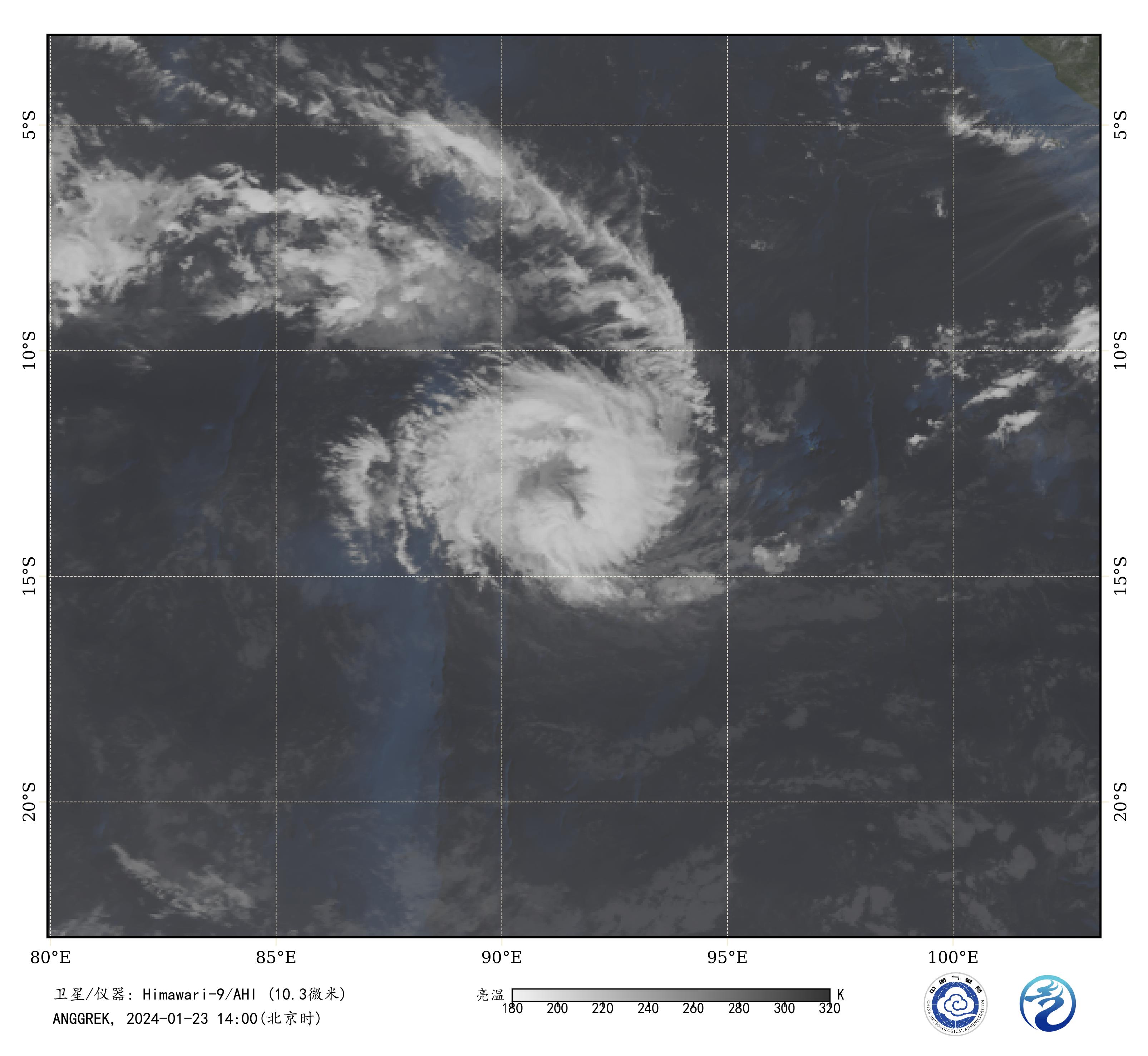
图1 卫星红外监测图像(北京时间2024年01月23日14时00分)
-
IDW27700
TROPICAL CYCLONE TECHNICAL BULLETIN: AUSTRALIA - WESTERN REGION
Issued by AUSTRALIAN BUREAU OF METEOROLOGY TROPICAL CYCLONE WARNING CENTRE
at: 1424 UTC 23/01/2024
Name: Tropical Cyclone Anggrek
Identifier: 04U
Data At: 1200 UTC
Latitude: 13.5S
Longitude: 91.4E
Location Accuracy: within 20nm (35 km)
Movement Towards: south southwest (205 deg)
Speed of Movement: 5 knots (10 km/h)
Maximum 10-Minute Wind: 45 knots (85 km/h)
Maximum 3-Second Wind Gust: 65 knots (120 km/h)
Central Pressure: 996 hPa
Radius of 34-knot winds NE quadrant: 70 nm (130 km)
Radius of 34-knot winds SE quadrant: 70 nm (130 km)
Radius of 34-knot winds SW quadrant: 70 nm (130 km)
Radius of 34-knot winds NW quadrant: 60 nm (110 km)
Radius of 48-knot winds NE quadrant:
Radius of 48-knot winds SE quadrant:
Radius of 48-knot winds SW quadrant:
Radius of 48-knot winds NW quadrant:
Radius of 64-knot winds:  nm ( km)
Radius of Maximum Winds: 25 nm (45 km)
Dvorak Intensity Code: T3.0/3.0/S0.0/24HRS STT:D0.5/12HRS
Pressure of outermost isobar: 1010 hPa
Radius of outermost closed isobar: 150 nm (280 km)
FORECAST DATA
Date/Time    : Location    : Loc. Accuracy: Max Wind   : Central Pressure
(UTC)        : degrees     :      nm  (km): knots(km/h): hPa
+06:  23/1800: 13.7S  91.3E:     035 (065):  050  (095):  992
+12:  24/0000: 13.9S  91.3E:     040 (080):  050  (095):  992
+18:  24/0600: 14.1S  91.1E:     050 (090):  055  (100):  988
+24:  24/1200: 14.3S  91.1E:     055 (095):  060  (110):  985
+36:  25/0000: 14.8S  90.6E:     060 (110):  065  (120):  982
+48:  25/1200: 15.5S  89.5E:     075 (140):  070  (130):  979
+60:  26/0000: 16.6S  88.0E:     095 (175):  065  (120):  983
+72:  26/1200: 17.8S  86.4E:     110 (200):  055  (100):  991
+96:  27/1200: 19.5S  83.3E:     155 (290):  050  (095):  992
+120: 28/1200: 20.4S  79.9E:     210 (390):  045  (085):  995
REMARKS:
Tropical Cyclone Anggrek has a slowly improving cloud signature indicating slow
intensification.

Position is based on an 0500 UTC microwave pass and animated visible imagery.
Confidence in the position is good. Satellite imagery in the last 6 hours has
become more symmetric with cloud tops becoming slightly colder.  Dvorak DT is
3.0 based on a continuous curved band of 0.8, enclosing a ragged eye feature.
MET is 3.5 based on a D- trend, PAT maintained at 3.5.  FT and CI held at 3.0
based on DT.  Objective aids received around 1100UTC were between 44 and 49 kn
(one-minute means). Intensity is set at 45 knots (10-min mean).

The environment is favourable with low vertical wind shear, SSTs around 28
degrees C along the forecast track, high PW surrounding the centre and a good
outflow channel to the NW. An upper trough southwest of the system will improve
outflow to the south as well.  This intensification phase is supported by the
majority of numerical models. The position of the upper trough is particularly
supportive on Wednesday and the start of Thursday and the forecast is for
Anggrek to intensify into a severe tropical cyclone (category 3). During
Thursday, shear increases and the system is expected to plateau in intensity
then start to weaken on Friday. There remains some ensemble members which
continue strengthening during this period.

Anggrek is moving slowly south southwest in a gap in the mid-level ridge to its
south. A strengthening ridge to the southeast is expected to maintain
southwesterly steering flow for the next few days. Anggrek is forecast to move
outside of the Australian area of responsibility sometime between 0000 UTC and
1200 UTC 25 January.

Copyright Commonwealth of Australia
==
The next bulletin for this system will be issued by: 23/1930 UTC.
Time (AWST) Intensity Category Latitude
(decimal deg.)Longitude
(decimal deg.)Estimated Position
Accuracy (km)0hr 8 pm January 23 1 13.5S 91.4E 35 +6hr 2 am January 24 2 13.7S 91.3E 65 +12hr 8 am January 24 2 13.9S 91.3E 80 +18hr 2 pm January 24 2 14.1S 91.1E 90 +24hr 8 pm January 24 2 14.3S 91.1E 95 +36hr 8 am January 25 3 14.8S 90.6E 110 +48hr 8 pm January 25 3 15.5S 89.5E 140 +60hr 8 am January 26 3 16.6S 88.0E 175 +72hr 8 pm January 26 2 17.8S 86.4E 200 最后于 2024-01-23 22:35:00 被ygsj24编辑 ,原因: -
IDW27700
TROPICAL CYCLONE TECHNICAL BULLETIN: AUSTRALIA - WESTERN REGION
Issued by AUSTRALIAN BUREAU OF METEOROLOGY TROPICAL CYCLONE WARNING CENTRE
at: 2001 UTC 23/01/2024
Name: Tropical Cyclone Anggrek
Identifier: 04U
Data At: 1800 UTC
Latitude: 13.7S
Longitude: 91.3E
Location Accuracy: within 20nm (35 km)
Movement Towards: south southwest (213 deg)
Speed of Movement: 4 knots (7 km/h)
Maximum 10-Minute Wind: 45 knots (85 km/h)
Maximum 3-Second Wind Gust: 65 knots (120 km/h)
Central Pressure: 995 hPa
Radius of 34-knot winds NE quadrant: 60 nm (110 km)
Radius of 34-knot winds SE quadrant: 70 nm (130 km)
Radius of 34-knot winds SW quadrant: 60 nm (110 km)
Radius of 34-knot winds NW quadrant: 50 nm (95 km)
Radius of 48-knot winds NE quadrant:
Radius of 48-knot winds SE quadrant:
Radius of 48-knot winds SW quadrant:
Radius of 48-knot winds NW quadrant:
Radius of 64-knot winds:  nm ( km)
Radius of Maximum Winds: 20 nm (35 km)
Dvorak Intensity Code: T3.0/3.0/D0.5/24HRS STT:S0.0/12HRS
Pressure of outermost isobar: 1010 hPa
Radius of outermost closed isobar: 150 nm (280 km)
FORECAST DATA
Date/Time    : Location    : Loc. Accuracy: Max Wind   : Central Pressure
(UTC)        : degrees     :      nm  (km): knots(km/h): hPa
+06:  24/0000: 13.9S  91.2E:     035 (060):  050  (095):  992
+12:  24/0600: 14.1S  91.1E:     045 (080):  055  (100):  989
+18:  24/1200: 14.3S  91.0E:     050 (090):  060  (110):  985
+24:  24/1800: 14.5S  90.8E:     055 (100):  065  (120):  981
+36:  25/0600: 15.2S  90.0E:     065 (120):  070  (130):  979
+48:  25/1800: 16.2S  88.6E:     080 (150):  070  (130):  980
+60:  26/0600: 17.5S  86.7E:     105 (190):  060  (110):  988
+72:  26/1800: 18.8S  84.8E:     125 (235):  050  (095):  993
+96:  27/1800: 20.2S  81.1E:     180 (335):  045  (085):  995
+120: 28/1800: 21.3S  77.1E:     230 (425):  040  (075):  999
REMARKS:
Tropical Cyclone Anggrek has maintained a well-structured LLCC and has
maintained near constant intensity overnight.

Good position fixes from 1217 UTC SAR, 1243 UTC SSMIS microwave and animated
visible imagery. Satellite imagery in the last 6 hours retained a partially
exposed LLCC with cold tops in a curved based through the eastern semicircle.
Dvorak DT is 3.0 based on curved band of 0.6. MET is 3.5 based on a D- trend,
PAT adjusted to 3.0.  FT and CI held at 3.0.  Objective aids received around
1630-1700UTC were between 43 and 53 kn (one-minute means). Intensity is set at
45 knots (10-min mean).

The environment is partly favourable with low vertical wind shear, SSTs around
28 degrees C along the forecast track and high PW surrounding the centre.
However, outflow has weakened despite an upper trough to the southwest and
mid-level dry air has wrapped around the periphery of the system. These factors
may have temporarily limited intensification overnight.

A period of intensification is forecast by the majority of numerical models.
The position of the upper trough is particularly supportive on Wednesday and
the start of Thursday and the forecast is for Anggrek to intensify into a
severe tropical cyclone (category 3). During Thursday, shear increases and the
system is expected to plateau in intensity then start to weaken on Friday.
There remains some ensemble members which continue strengthening during this
period.

Anggrek is moving slowly south southwest in a gap in the mid-level ridge to its
south. A strengthening ridge to the southeast is expected to maintain
southwesterly steering flow for the next few days. Anggrek is forecast to move
outside of the Australian area of responsibility sometime between 0000 UTC and
1200 UTC 25 January.

Copyright Commonwealth of Australia
==
The next bulletin for this system will be issued by: 24/0130 UTC.
Time (AWST) Intensity Category Latitude
(decimal deg.)Longitude
(decimal deg.)Estimated Position
Accuracy (km)0hr 2 am January 24 1 13.7S 91.3E 35 +6hr 8 am January 24 2 13.9S 91.2E 60 +12hr 2 pm January 24 2 14.1S 91.1E 80 +18hr 8 pm January 24 2 14.3S 91.0E 90 +24hr 2 am January 25 3 14.5S 90.8E 100 +36hr 2 pm January 25 3 15.2S 90.0E 120 +48hr 2 am January 26 3 16.2S 88.6E 150 +60hr 2 pm January 26 2 17.5S 86.7E 190 +72hr 2 am January 27 2 18.8S 84.8E 235