最新回复 (48)
-

IDQ20018
TROPICAL CYCLONE TECHNICAL BULLETIN: AUSTRALIA - EASTERN REGION
Issued by AUSTRALIAN BUREAU OF METEOROLOGY TROPICAL CYCLONE WARNING CENTRE
at: 0125 UTC 22/01/2024
Name: Tropical Low
Identifier: 05U
Data At: 0000 UTC
Latitude: 15.3S
Longitude: 153.8E
Location Accuracy: within 30nm (55 km)
Movement Towards: west (280 deg)
Speed of Movement: 1 knots (3 km/h)
Maximum 10-Minute Wind: 30 knots (55 km/h)
Maximum 3-Second Wind Gust: 45 knots (85 km/h)
Central Pressure: 998 hPa
Radius of 34-knot winds NE quadrant:
Radius of 34-knot winds SE quadrant:
Radius of 34-knot winds SW quadrant:
Radius of 34-knot winds NW quadrant:
Radius of 48-knot winds NE quadrant:
Radius of 48-knot winds SE quadrant:
Radius of 48-knot winds SW quadrant:
Radius of 48-knot winds NW quadrant:
Radius of 64-knot winds:  nm ( km)
Radius of Maximum Winds:   nm (  km)
Dvorak Intensity Code: T2.0/2.0/D0.5/24HRS STT:D0.5/06HRS
Pressure of outermost isobar: 1004 hPa
Radius of outermost closed isobar: 260 nm (480 km)
FORECAST DATA
Date/Time    : Location    : Loc. Accuracy: Max Wind   : Central Pressure
(UTC)        : degrees     :      nm  (km): knots(km/h): hPa
+06:  22/0600: 15.5S 153.6E:     045 (085):  035  (065):  994
+12:  22/1200: 15.6S 153.4E:     055 (105):  035  (065):  994
+18:  22/1800: 15.8S 153.3E:     065 (120):  035  (065):  993
+24:  23/0000: 16.1S 153.2E:     075 (140):  040  (075):  991
+36:  23/1200: 16.7S 152.7E:     085 (160):  050  (095):  985
+48:  24/0000: 17.3S 151.8E:     100 (185):  060  (110):  978
+60:  24/1200: 17.9S 150.1E:     115 (210):  070  (130):  971
+72:  25/0000: 18.8S 147.9E:     130 (240):  080  (150):  960
+96:  26/0000: 21.4S 144.5E:     180 (330):  030  (055):  999
+120: 27/0000: 22.9S 145.5E:     235 (440):  030  (055):  997
REMARKS:
Tropical Low 05U remains slow to develop in the Coral Sea.

Position based on VIS satellite imagery with medium confidence as it remains an
elongated low level centre. Intensity at 30kn based on Dvorak estimates and
ASCAT pass at 1153 UTC. Dvorak analysis: DT = 2.0 based on curved band wrap of
0.2-0.3. MET = 1.5. FT/CI = 2.0 based on DT. No objective guidance at this
early stage of development.

SSTs remain high along the track at about 30 deg. Celcius. Vertical wind shear
15 to 20 knots over the system, slowing the development. There remains strong
upper divergence with an upper trough to the south. Moisture remains high over
the system, with some drier air well to the south.

The forecast track is based on a consensus of global numerical weather
prediction models. There is good consistency between the guidance for a coastal
crossing between Innisfail and Airlie Beach on Thursday. During Thursday and
into Friday, the system is forecast to track well inland towards Charters
Towers and Longreach with heavy rain and strong winds likely along its path.
Over the weekend, the track takes the system further south, with heavy rain and
strong winds possible for southern Queensland.

05U is forecast to intensify over the next 24 hours to a Category 1 tropical
cyclone, then continue to intensify as it tracks towards the coast with a
Category 3 coastal crossing most likely.

Copyright Commonwealth of Australia
==
The next bulletin for this system will be issued by: 22/0730 UTC.
Time (AEST) Intensity Category Latitude
(decimal deg.)Longitude
(decimal deg.)Estimated Position
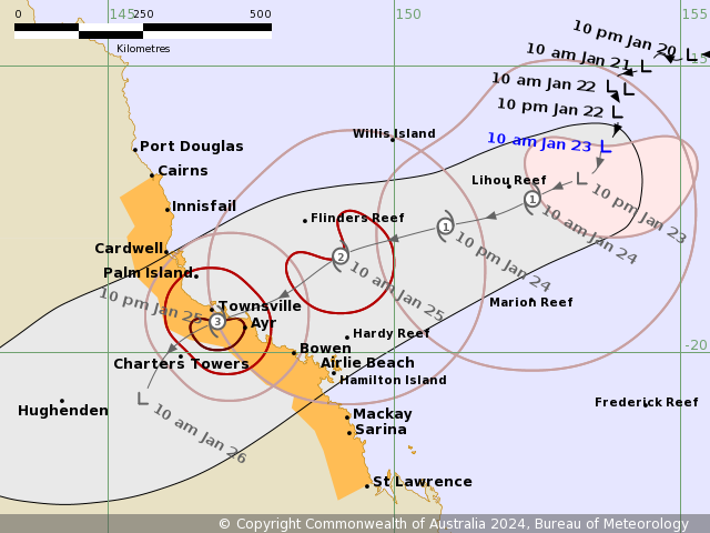
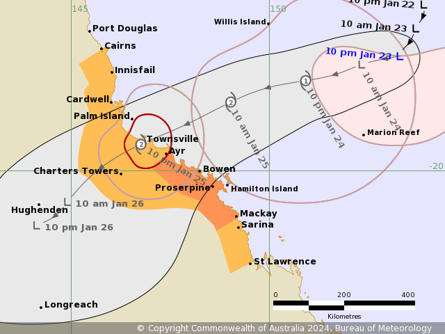
Accuracy (km)0hr 10 am January 22 tropical low 15.3S 153.8E 55 +6hr 4 pm January 22 tropical low 15.5S 153.6E 85 +12hr 10 pm January 22 tropical low 15.6S 153.4E 105 +18hr 4 am January 23 tropical low 15.8S 153.3E 120 +24hr 10 am January 23 1 16.1S 153.2E 140 +36hr 10 pm January 23 2 16.7S 152.7E 160 +48hr 10 am January 24 2 17.3S 151.8E 185 +60hr 10 pm January 24 3 17.9S 150.1E 210 +72hr 10 am January 25 3 18.8S 147.9E 240 最后于 2024-01-22 09:30:00 被ygsj24编辑 ,原因: -
IDQ20018
TROPICAL CYCLONE TECHNICAL BULLETIN: AUSTRALIA - EASTERN REGION
Issued by AUSTRALIAN BUREAU OF METEOROLOGY TROPICAL CYCLONE WARNING CENTRE
at: 0710 UTC 22/01/2024
Name: Tropical Low
Identifier: 05U
Data At: 0600 UTC
Latitude: 15.6S
Longitude: 153.9E
Location Accuracy: within 30nm (55 km)
Movement Towards: south (180 deg)
Speed of Movement: 1 knots (2 km/h)
Maximum 10-Minute Wind: 30 knots (55 km/h)
Maximum 3-Second Wind Gust: 45 knots (85 km/h)
Central Pressure: 998 hPa
Radius of 34-knot winds NE quadrant:
Radius of 34-knot winds SE quadrant:
Radius of 34-knot winds SW quadrant:
Radius of 34-knot winds NW quadrant:
Radius of 48-knot winds NE quadrant:
Radius of 48-knot winds SE quadrant:
Radius of 48-knot winds SW quadrant:
Radius of 48-knot winds NW quadrant:
Radius of 64-knot winds:  nm ( km)
Radius of Maximum Winds:   nm (  km)
Dvorak Intensity Code: T2.0/2.0/D0.5/24HRS STT:S0.0/06HRS
Pressure of outermost isobar: 1004 hPa
Radius of outermost closed isobar: 280 nm (520 km)
FORECAST DATA
Date/Time    : Location    : Loc. Accuracy: Max Wind   : Central Pressure
(UTC)        : degrees     :      nm  (km): knots(km/h): hPa
+06:  22/1200: 15.8S 153.9E:     045 (085):  030  (055):  998
+12:  22/1800: 16.0S 153.7E:     060 (105):  030  (055):  998
+18:  23/0000: 16.4S 153.3E:     065 (120):  035  (065):  994
+24:  23/0600: 16.6S 153.0E:     070 (130):  040  (075):  992
+36:  23/1800: 17.1S 152.2E:     085 (160):  050  (095):  985
+48:  24/0600: 17.7S 150.8E:     095 (180):  060  (110):  979
+60:  24/1800: 18.4S 148.9E:     115 (215):  070  (130):  968
+72:  25/0600: 19.6S 146.6E:     135 (250):  065  (120):  974
+96:  26/0600: 22.3S 144.5E:     185 (345):  030  (055):  998
+120: 27/0600: 23.1S 146.8E:     250 (460):  030  (055):  998
REMARKS:
Tropical Low 05U remains slow to develop in the Coral Sea.

Position based on VIS satellite imagery with medium to low confidence as it
remains an elongated low level centre. Intensity at 30kn based on Dvorak
estimates and ASCAT pass at 1153 UTC. Dvorak analysis: DT = 2.0 based on curved
band wrap of 0.2-0.3. MET = 2.0. FT/CI = 2.0 based on DT. No objective guidance
at this early stage of development.

SSTs remain high along the track at about 30 degrees Celsius. Vertical wind
shear shows a thin low shear band just south of the LLC, with moderate to high
shear away from this band. This, coupled with the large size and elongated low
level centre is slowing development. There remains strong upper divergence with
an upper trough to the south. Moisture remains high over the system, with some
drier air well to the south.

The forecast track is based on a consensus of global numerical weather
prediction models. There is good consistency between the guidance for a coastal
crossing between Innisfail and Airlie Beach on Thursday. During Thursday and
into Friday, the system is forecast to track well inland towards Charters
Towers and Longreach with heavy rain and strong winds likely along its path.
Over the weekend, the track takes the system further south, with heavy rain and
strong winds possible for southern Queensland.

05U is forecast to intensify over the next 24 hours to a Category 1 tropical
cyclone, then continue to intensify at the standard rate in a moderately
favourable environment which sees it reach a max intensity of 70 knots prior to
land fall. Due to the current elongated low level centre and the possibility of
vertical wind shear persisting, the strengthening could be slower than
forecast.

Copyright Commonwealth of Australia
==
The next bulletin for this system will be issued by: 22/1330 UTC.
Time (AEST) Intensity Category Latitude
(decimal deg.)Longitude
(decimal deg.)Estimated Position
Accuracy (km)0hr 4 pm January 22 tropical low 15.6S 153.9E 55 +6hr 10 pm January 22 tropical low 15.8S 153.9E 85 +12hr 4 am January 23 tropical low 16.0S 153.7E 105 +18hr 10 am January 23 tropical low 16.4S 153.3E 120 +24hr 4 pm January 23 1 16.6S 153.0E 130 +36hr 4 am January 24 2 17.1S 152.2E 160 +48hr 4 pm January 24 2 17.7S 150.8E 180 +60hr 4 am January 25 3 18.4S 148.9E 215 +72hr 4 pm January 25 3 19.6S 146.6E 250 -
IDQ20018
TROPICAL CYCLONE TECHNICAL BULLETIN: AUSTRALIA - EASTERN REGION
Issued by AUSTRALIAN BUREAU OF METEOROLOGY TROPICAL CYCLONE WARNING CENTRE
at: 1248 UTC 22/01/2024
Name: Tropical Low
Identifier: 05U
Data At: 1200 UTC
Latitude: 15.8S
Longitude: 153.9E
Location Accuracy: within 40nm (75 km)
Movement Towards: south southeast (168 deg)
Speed of Movement: 2 knots (4 km/h)
Maximum 10-Minute Wind: 30 knots (55 km/h)
Maximum 3-Second Wind Gust: 45 knots (85 km/h)
Central Pressure: 998 hPa
Radius of 34-knot winds NE quadrant:
Radius of 34-knot winds SE quadrant:
Radius of 34-knot winds SW quadrant:
Radius of 34-knot winds NW quadrant:
Radius of 48-knot winds NE quadrant:
Radius of 48-knot winds SE quadrant:
Radius of 48-knot winds SW quadrant:
Radius of 48-knot winds NW quadrant:
Radius of 64-knot winds:  nm ( km)
Radius of Maximum Winds:   nm (  km)
Dvorak Intensity Code: T2.0/2.0/S0.0/24HRS STT:S0.0/06HRS
Pressure of outermost isobar: 1004 hPa
Radius of outermost closed isobar: 280 nm (520 km)
FORECAST DATA
Date/Time    : Location    : Loc. Accuracy: Max Wind   : Central Pressure
(UTC)        : degrees     :      nm  (km): knots(km/h): hPa
+06:  22/1800: 15.9S 153.6E:     055 (100):  030  (055):  998
+12:  23/0000: 16.2S 153.4E:     065 (115):  035  (065):  993
+18:  23/0600: 16.5S 153.1E:     070 (130):  040  (075):  992
+24:  23/1200: 16.8S 152.9E:     075 (140):  045  (085):  988
+36:  24/0000: 17.4S 152.0E:     085 (155):  050  (095):  986
+48:  24/1200: 17.9S 150.3E:     095 (180):  060  (110):  980
+60:  25/0000: 18.6S 148.3E:     115 (215):  070  (130):  969
+72:  25/1200: 19.7S 146.1E:     135 (250):  050  (095):  986
+96:  26/1200: 22.4S 145.1E:     180 (335):  030  (055):  997
+120: 27/1200: 23.1S 148.1E:     240 (450):  030  (055):  998
REMARKS:
Tropical Low 05U continues to develop only slowly. Convection remains generally
unfocussed along the monsoon trough with periodic flare-ups near the estimated
low level centre of 05U, which have at times shown some curvature.

Position based on EIR, an afternoon microwave pass and a SMOS pass at 0742z
with medium to low confidence, as the centre is possibly still somewhat
elongated. Intensity at 30kn based on Dvorak estimates. Dvorak analysis: DT =
2.0 based on curved band wrap of 0.2-0.3, however this is highly dependent of
the centre location and there is low confidence in that. A 24 hour trend of S
was applied giving a MET = 2.0, no PAT adjustment made so FT/CI = 2.0. No
objective guidance at this early stage of development.

SSTs remain high along the track at about 30 degrees Celsius. Moisture remains
high over the system, with some drier air well to the south. CIMSS upper level
winds display good divergence in the vicinity of the system with an upper
trough to the southwest enhancing poleward outflow. CIMSS vertical wind shear
shows a thin low shear band just south of the estimated LLC, with moderate to
high easterly shear to the north of this band. This, coupled with the large
system size and elongated low level centre has been slowing development and
making the short term intensity forecast difficult.

The upper trough should interact with the system over the next 24 to 36 hours,
with slow SSW to SW'ly motion and slow development expected. From about
Wednesday onward the upper trough will move east and a cradling mid-level ridge
should accelerate the system to the WSW towards the Queensland coast. At the
same time, deep layer vertical wind shear is forecast to decrease and the rate
of development should consequently increase. The landfall intensity is
maintained at 70 knots (category 3).

The forecast track is based on a consensus of global numerical weather
prediction models. There is good consistency between the guidance for a coastal
crossing between Innisfail and Airlie Beach on Thursday. During Thursday and
into Friday, the system is forecast to track well inland towards Charters
Towers and Longreach with heavy rain and strong winds likely along its path.
Over the weekend, the track takes the system further south, with heavy rain and
strong winds possible for southern Queensland.

Copyright Commonwealth of Australia
==
The next bulletin for this system will be issued by: 22/1930 UTC.
Time (AEST) Intensity Category Latitude
(decimal deg.)Longitude
(decimal deg.)Estimated Position
Accuracy (km)0hr 10 pm January 22 tropical low 15.8S 153.9E 75 +6hr 4 am January 23 tropical low 15.9S 153.6E 100 +12hr 10 am January 23 tropical low 16.2S 153.4E 115 +18hr 4 pm January 23 1 16.5S 153.1E 130 +24hr 10 pm January 23 1 16.8S 152.9E 140 +36hr 10 am January 24 2 17.4S 152.0E 155 +48hr 10 pm January 24 2 17.9S 150.3E 180 +60hr 10 am January 25 3 18.6S 148.3E 215 +72hr 10 pm January 25 2 19.7S 146.1E 250 -
IDQ20018
TROPICAL CYCLONE TECHNICAL BULLETIN: AUSTRALIA - EASTERN REGION
Issued by AUSTRALIAN BUREAU OF METEOROLOGY TROPICAL CYCLONE WARNING CENTRE
at: 1946 UTC 22/01/2024
Name: Tropical Low
Identifier: 05U
Data At: 1800 UTC
Latitude: 16.0S
Longitude: 153.9E
Location Accuracy: within 40nm (75 km)
Movement Towards: south (180 deg)
Speed of Movement: 2 knots (4 km/h)
Maximum 10-Minute Wind: 30 knots (55 km/h)
Maximum 3-Second Wind Gust: 45 knots (85 km/h)
Central Pressure: 996 hPa
Radius of 34-knot winds NE quadrant:
Radius of 34-knot winds SE quadrant:
Radius of 34-knot winds SW quadrant:
Radius of 34-knot winds NW quadrant:
Radius of 48-knot winds NE quadrant:
Radius of 48-knot winds SE quadrant:
Radius of 48-knot winds SW quadrant:
Radius of 48-knot winds NW quadrant:
Radius of 64-knot winds:  nm ( km)
Radius of Maximum Winds:   nm (  km)
Dvorak Intensity Code: T2.0/2.0/D0.5/24HRS STT:S0.0/06HRS
Pressure of outermost isobar: 1002 hPa
Radius of outermost closed isobar: 240 nm (445 km)
FORECAST DATA
Date/Time    : Location    : Loc. Accuracy: Max Wind   : Central Pressure
(UTC)        : degrees     :      nm  (km): knots(km/h): hPa
+06:  23/0000: 16.3S 153.9E:     055 (100):  030  (055):  996
+12:  23/0600: 16.6S 153.8E:     065 (115):  030  (055):  996
+18:  23/1200: 16.7S 153.7E:     065 (120):  035  (065):  990
+24:  23/1800: 17.0S 153.6E:     070 (130):  040  (075):  988
+36:  24/0600: 17.4S 152.6E:     075 (135):  040  (075):  989
+48:  24/1800: 17.9S 150.8E:     085 (160):  045  (085):  987
+60:  25/0600: 18.7S 148.9E:     120 (220):  055  (100):  981
+72:  25/1800: 19.7S 146.7E:     140 (260):  050  (095):  984
+96:  26/1800: 21.7S 145.3E:     185 (340):  030  (055):  995
+120: 27/1800: 22.2S 146.3E:     220 (405):  025  (045):  998
REMARKS:
Tropical Low 05U continues to develop only slowly. Convection remains generally
unfocussed along the monsoon trough although the latest imagery is showing more
definitive curvature.
Position based on EIR supported by microwave pass noting the centre appears
still somewhat elongated. Intensity at 30kn based on surface observations
(LIhou Reef) and earlier ASCAT passes. Dvorak analysis: DT = 2.0 based on
curved band wrap of 0.2-0.4; MET=1.5 adjusted to 2.0 on PAT; so FT/CI = 2.0. No
objective guidance at this early stage of development.
Although the circulation has failed to consolidate, the general environment
remains conducive for development. SSTs remain high along the track at about 30
degrees Celsius. Moisture remains high over the system. CIMSS upper level winds
display good divergence in the vicinity of the system with an upper trough to
the southwest enhancing poleward outflow. CIMSS vertical wind shear shows a
thin low shear band in the vicinity of the circulation. This, coupled with the
large system size and elongated low level centre has been slowing development
and making the short term intensity forecast difficult.
The current slow SSW to SW'ly motion should persist in the next 24 hours with
slow development expected. From about Wednesday onward the upper trough will
move east and a cradling mid-level ridge should accelerate the system to the
WSW towards the Queensland coast. The most recent NWP guidance has lowered the
forecast intensity despite the overall favourable environment. The forecast
intensity by landfall of 65kn (category 3) is a little higher than most NWP
guidance at this stage.
The forecast track is based on a consensus of global numerical weather
prediction models. There is good consistency between the guidance for a coastal
crossing between Cardwell and Airlie Beach overnight Thursday into Friday.
During Friday, the system is forecast to track well inland with heavy rain and
strong winds likely along its path. Over the weekend, the track takes the
system further south, with heavy rain and strong winds possible for southern
Queensland.

Copyright Commonwealth of Australia
==
The next bulletin for this system will be issued by: 23/0130 UTC.
Time (AEST) Intensity Category Latitude
(decimal deg.)Longitude
(decimal deg.)Estimated Position
Accuracy (km)0hr 4 am January 23 tropical low 16.0S 153.9E 75 +6hr 10 am January 23 tropical low 16.3S 153.9E 100 +12hr 4 pm January 23 tropical low 16.6S 153.8E 115 +18hr 10 pm January 23 tropical low 16.7S 153.7E 120 +24hr 4 am January 24 1 17.0S 153.6E 130 +36hr 4 pm January 24 1 17.4S 152.6E 135 +48hr 4 am January 25 1 17.9S 150.8E 160 +60hr 4 pm January 25 2 18.7S 148.9E 220 +72hr 4 am January 26 2 19.7S 146.7E 260 -
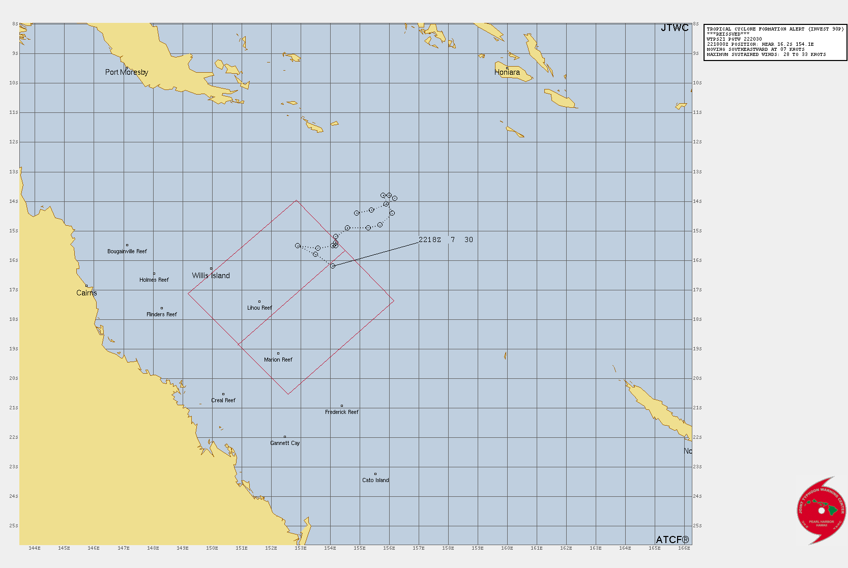
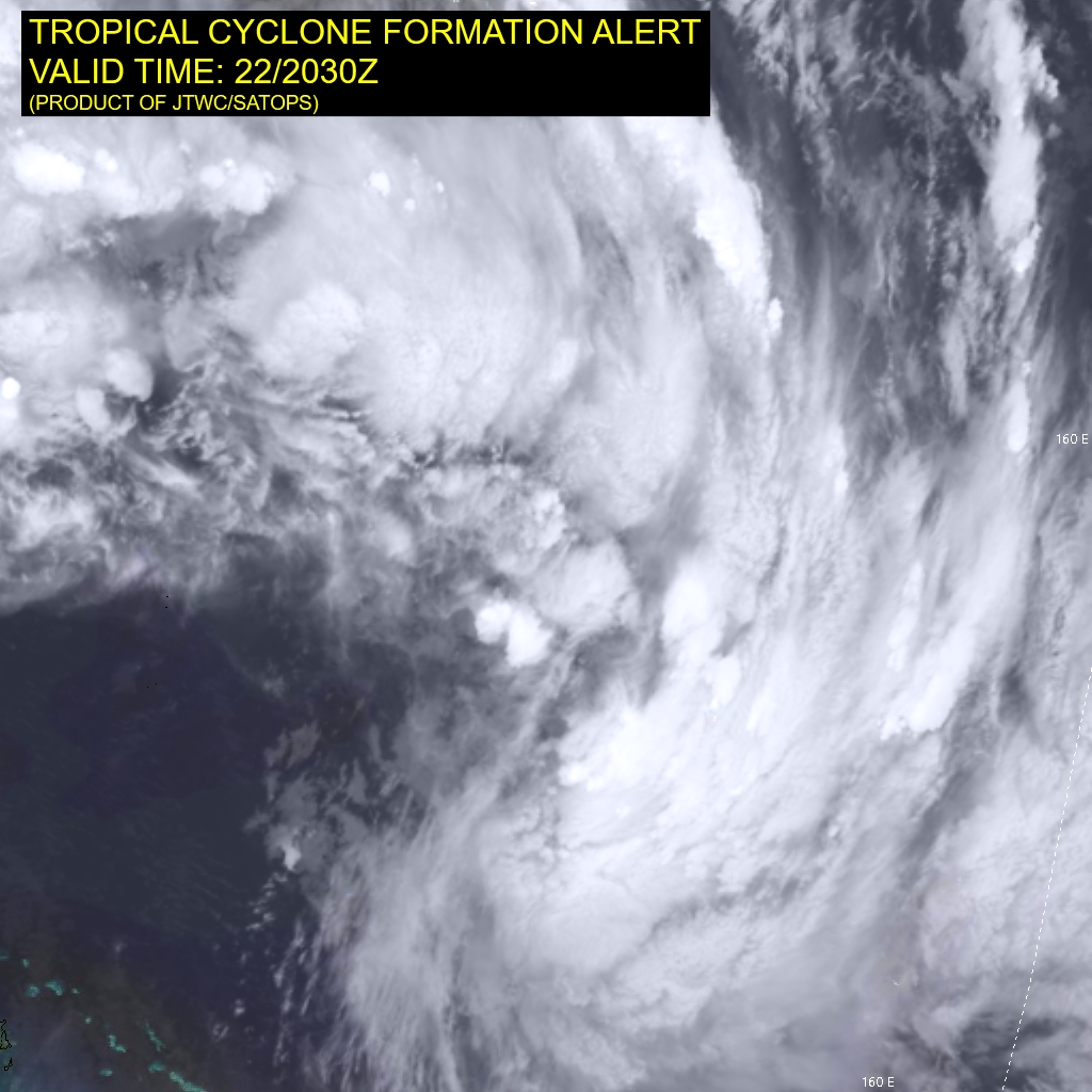
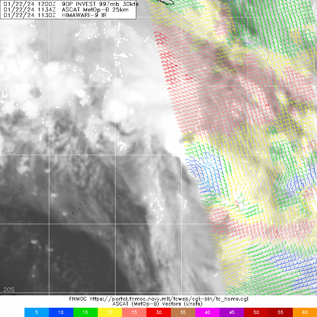
WTPS21 PGTW 222030
MSGID/GENADMIN/JOINT TYPHOON WRNCEN PEARL HARBOR HI//
SUBJ/TROPICAL CYCLONE FORMATION ALERT (INVEST 90P) REISSUED//
REF/A/JOINT TYPHOON WRNCEN PEARL HARBOR HI/212021ZJAN2024//
AMPN/REF A IS A TROPICAL CYCLONE FORMATION ALERT.//
RMKS/
1. FORMATION OF A SIGNIFICANT TROPICAL CYCLONE IS POSSIBLE WITHIN
140 NM EITHER SIDE OF A LINE FROM 15.7S 154.5E TO 18.9S 150.9E
WITHIN THE NEXT 12 TO 24 HOURS. AVAILABLE DATA DOES NOT JUSTIFY
ISSUANCE OF NUMBERED TROPICAL CYCLONE WARNINGS AT THIS TIME.
WINDS IN THE AREA ARE ESTIMATED TO BE 28 TO 33 KNOTS. METSAT
IMAGERY AT 221930Z INDICATES THAT A CIRCULATION CENTER IS LOCATED
NEAR 16.2S 154.1E. THE SYSTEM IS MOVING SOUTHEASTWARD AT 07
KNOTS.
2. REMARKS: THE AREA OF CONVECTION (INVEST 90P) PREVIOUSLY LOCATED NEAR
15.5S 154.1E IS NOW LOCATED NEAR 16.2S 154.1E, APPROXIMATELY 237 NM EAST
OF WILLIS ISLAND. TROPICAL DISTURBANCE 90P IS SLOWLY DEVELOPING, WITH
CONVECTION SPORADIC AND DISPLACED TO THE EQUATORWARD SIDE OF THE SYSTEM.
ANIMATED SHORTWAVE INFRARED IMAGERY SHOWS THAT THE CONVECTION HAS EBBED
AND FLOWED DURING THE PAST TWELVE HOURS AND NOT ESPECIALLY DEEPENED
DESPITE THE FACT THAT THE SYSTEM IS MOVING INTO THE DIURNAL MAXIMUM
PERIOD. RECENT SATELLITE IMAGERY DOES SHOW VIGOROUS SOUTHEASTERLIES
ALONG THE WESTERN FLANK OF THE ELONGATED CONVECTIVE SHIELD BEGINNING TO
MAKE THE TURN INTO THE EQUATORWARD SIDE OF THE CIRCULATION BUT IT WILL
TAKE A FEW MORE HOURS ANIMATED TOTAL PRECIPITABLE WATER LOOPS ALSO SHOW
THAT DEEP CONVECTION IS STILL STRUGGLING TO COCOON THE SYSTEM. A 221134Z
PARTIAL ASCAT-B IMAGE CONFIRMS A LACK OF 30KT WINDFIELDS ON THE EASTERN
HALF OF THE SYSTEM. THE WESTERN HALF MISSED. THE ABRF CAME IN A T2.0
CONFIRMING THE CURRENT INTENSITY ASSESSMENT. ENVIRONMENTAL ANALYSIS
INDICATES THAT 90P IS IN A FAVORABLE ENVIRONMENT FOR DEVELOPMENT WITH
ROBUST POLEWARD OUTFLOW ALOFT, LOW (10 -15 KTS) VERTICAL WIND SHEAR, AND
WARM (29-30 C) SEA SURFACE TEMPERATURES. GLOBAL MODELS ARE IN GOOD
AGREEMENT THAT 90P WILL TRACK GENERALLY SOUTHWESTWARD AND DEEPEN TO
TROPICAL STROM STRENGTH WITHIN THE NEXT TWELVE HOURS. MAXIMUM SUSTAINED
SURFACE WINDS ARE ESTIMATED AT 28 TO 33 KNOTS. MINIMUM SEA LEVEL
PRESSURE IS ESTIMATED TO BE NEAR 997 MB. THE POTENTIAL FOR THE
DEVELOPMENT OF A SIGNIFICANT TROPICAL CYCLONE
WITHIN THE NEXT 24 HOURS REMAINS HIGH. THIS SUPERSEDES REF A (WTPS21
PGTW 212030).
3. THIS ALERT WILL BE REISSUED, UPGRADED TO WARNING OR CANCELLED BY
232030Z.//
NNNN
 最后于 2024-01-23 06:00:00 被ygsj24编辑 ,原因:
 -
IDQ20018
TROPICAL CYCLONE TECHNICAL BULLETIN: AUSTRALIA - EASTERN REGION
Issued by AUSTRALIAN BUREAU OF METEOROLOGY TROPICAL CYCLONE WARNING CENTRE
at: 0123 UTC 23/01/2024
Name: Tropical Low
Identifier: 05U
Data At: 0000 UTC
Latitude: 16.3S
Longitude: 153.7E
Location Accuracy: within 20nm (35 km)
Movement Towards: south southwest (201 deg)
Speed of Movement: 3 knots (5 km/h)
Maximum 10-Minute Wind: 35 knots (65 km/h)
Maximum 3-Second Wind Gust: 50 knots (95 km/h)
Central Pressure: 996 hPa
Radius of 34-knot winds NE quadrant:
Radius of 34-knot winds SE quadrant: 100 nm (185 km)
Radius of 34-knot winds SW quadrant: 90 nm (165 km)
Radius of 34-knot winds NW quadrant:
Radius of 48-knot winds NE quadrant:
Radius of 48-knot winds SE quadrant:
Radius of 48-knot winds SW quadrant:
Radius of 48-knot winds NW quadrant:
Radius of 64-knot winds:  nm ( km)
Radius of Maximum Winds:   nm (  km)
Dvorak Intensity Code: T2.5/2.5/D0.5/24HRS STT:D0.5/06HRS
Pressure of outermost isobar: 1004 hPa
Radius of outermost closed isobar: 250 nm (465 km)
FORECAST DATA
Date/Time    : Location    : Loc. Accuracy: Max Wind   : Central Pressure
(UTC)        : degrees     :      nm  (km): knots(km/h): hPa
+06:  23/0600: 16.6S 153.6E:     045 (085):  035  (065):  996
+12:  23/1200: 16.9S 153.4E:     055 (105):  035  (065):  995
+18:  23/1800: 17.1S 152.9E:     065 (120):  040  (075):  993
+24:  24/0000: 17.3S 152.4E:     075 (135):  040  (075):  993
+36:  24/1200: 17.8S 150.9E:     075 (140):  045  (085):  991
+48:  25/0000: 18.3S 149.1E:     095 (175):  055  (100):  983
+60:  25/1200: 19.5S 146.9E:     120 (220):  065  (120):  979
+72:  26/0000: 20.8S 145.6E:     135 (250):  030  (055):  999
+96:  27/0000: 22.1S 145.4E:     175 (320):  030  (055):  997
+120: 28/0000: 22.2S 146.6E:     235 (435):  025  (045): 1000
REMARKS:
Gale-force winds observed this morning to the south of Tropical Low 05U.

Position based on ASCAT scatterometer pass at 2243 UTC supported by VIS
satellite imagery with an elongated low-level centre. Intensity at 35kn based
on ASCAT winds. Dvorak analysis: DT = 2.0 based on curved band wrap of 0.3-0.4;
MET/PAT=2.5 based on slight development over last 24 hours. FT/CI = 2.5. No
objective guidance at this early stage of development.

Although the circulation has failed to consolidate, the general environment
remains conducive for development. SSTs remain high along the track at about 30
degrees Celsius. Moisture remains high over the system. CIMSS upper level winds
display good divergence in the vicinity of the system with an upper trough to
the southwest enhancing poleward outflow. CIMSS vertical wind shear shows a
thin low shear band in the vicinity of the circulation. This, coupled with the
large system size and elongated low level centre has been slowing development
and making the short term intensity forecast difficult.

The current slow SSW to SW'ly motion should persist in the next 24 hours with
slow development expected. From about Wednesday onward the upper trough will
move east and a cradling mid-level ridge should accelerate the system to the
WSW towards the Queensland coast. The most recent NWP guidance has lowered the
forecast intensity despite the overall favourable environment. The forecast
intensity by landfall of 65kn (category 3) is supported by standard development
from Wednesday into Thursday.

The forecast track is based on a consensus of global numerical weather
prediction models. There is good consistency between the guidance for a coastal
crossing between Cardwell and Airlie Beach Thursday evening. However, there
remains significant uncertainty in the timing of the crossing from as early as
Thursday midday to about Friday midday. This is represented by a narrow and
long 72 hour confidence cone with the track possibly as far west as Winton by
Friday afternoon.

During Friday, the system is forecast to track well inland with heavy rain and
strong winds likely along its path. Over the weekend, the track takes the
system further south, with heavy rain and strong winds possible for southern
and central Queensland. In the longer term, the system is likely to remain a
tropical low over inland Queensland which may bring further heavy rain for
parts of Queensland.

Copyright Commonwealth of Australia
==
The next bulletin for this system will be issued by: 23/0730 UTC.
Time (AEST) Intensity Category Latitude
(decimal deg.)Longitude
(decimal deg.)Estimated Position
Accuracy (km)0hr 10 am January 23 tropical low 16.3S 153.7E 35 +6hr 4 pm January 23 tropical low 16.6S 153.6E 85 +12hr 10 pm January 23 tropical low 16.9S 153.4E 105 +18hr 4 am January 24 1 17.1S 152.9E 120 +24hr 10 am January 24 1 17.3S 152.4E 135 +36hr 10 pm January 24 1 17.8S 150.9E 140 +48hr 10 am January 25 2 18.3S 149.1E 175 +60hr 10 pm January 25 3 19.5S 146.9E 220 +72hr 10 am January 26 tropical low 20.8S 145.6E 250 最后于 2024-01-23 09:35:00 被ygsj24编辑 ,原因: -
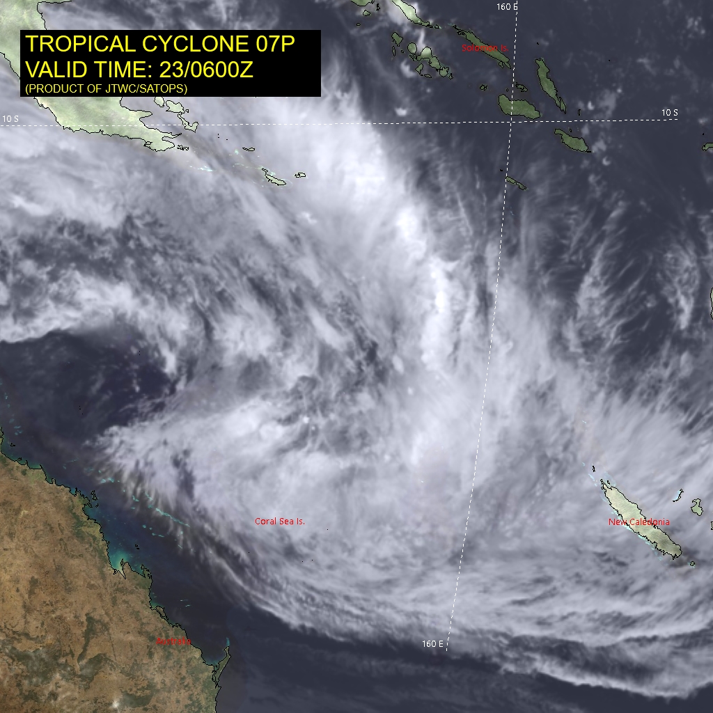
WTPS31 PGTW 230300
MSGID/GENADMIN/JOINT TYPHOON WRNCEN PEARL HARBOR HI//
SUBJ/TROPICAL CYCLONE 07P (SEVEN) WARNING NR 001//
REF/A/JOINT TYPHOON WRNCEN PEARL HARBOR HI/212021ZJAN2024//
AMPN/REF A IS A TROPICAL CYCLONE FORMATION ALERT.//
RMKS/
1. TROPICAL CYCLONE 07P (SEVEN) WARNING NR 001
   01 ACTIVE TROPICAL CYCLONE IN SOUTHPAC
   MAX SUSTAINED WINDS BASED ON ONE-MINUTE AVERAGE
   WIND RADII VALID OVER OPEN WATER ONLY
    ---
   WARNING POSITION:
   230000Z --- NEAR 16.6S 153.7E
     MOVEMENT PAST SIX HOURS - 225 DEGREES AT 06 KTS
     POSITION ACCURATE TO WITHIN 060 NM
     POSITION BASED ON CENTER LOCATED BY SATELLITE
   PRESENT WIND DISTRIBUTION:
   MAX SUSTAINED WINDS - 035 KT, GUSTS 045 KT
   WIND RADII VALID OVER OPEN WATER ONLY
   RADIUS OF 034 KT WINDS - 025 NM NORTHEAST QUADRANT
                            025 NM SOUTHEAST QUADRANT
                            025 NM SOUTHWEST QUADRANT
                            025 NM NORTHWEST QUADRANT
   REPEAT POSIT: 16.6S 153.7E
    ---
   FORECASTS:
   12 HRS, VALID AT:
   231200Z --- 17.0S 153.4E
   MAX SUSTAINED WINDS - 045 KT, GUSTS 055 KT
   WIND RADII VALID OVER OPEN WATER ONLY
   RADIUS OF 034 KT WINDS - 050 NM NORTHEAST QUADRANT
                            070 NM SOUTHEAST QUADRANT
                            060 NM SOUTHWEST QUADRANT
                            050 NM NORTHWEST QUADRANT
   VECTOR TO 24 HR POSIT: 235 DEG/ 05 KTS
    ---
   24 HRS, VALID AT:
   240000Z --- 17.5S 152.6E
   MAX SUSTAINED WINDS - 050 KT, GUSTS 065 KT
   WIND RADII VALID OVER OPEN WATER ONLY
   RADIUS OF 050 KT WINDS - 000 NM NORTHEAST QUADRANT
                            000 NM SOUTHEAST QUADRANT
                            040 NM SOUTHWEST QUADRANT
                            020 NM NORTHWEST QUADRANT
   RADIUS OF 034 KT WINDS - 090 NM NORTHEAST QUADRANT
                            150 NM SOUTHEAST QUADRANT
                            130 NM SOUTHWEST QUADRANT
                            070 NM NORTHWEST QUADRANT
   VECTOR TO 36 HR POSIT: 250 DEG/ 07 KTS
    ---
   36 HRS, VALID AT:
   241200Z --- 18.0S 151.2E
   MAX SUSTAINED WINDS - 055 KT, GUSTS 070 KT
   WIND RADII VALID OVER OPEN WATER ONLY
   RADIUS OF 050 KT WINDS - 030 NM NORTHEAST QUADRANT
                            000 NM SOUTHEAST QUADRANT
                            040 NM SOUTHWEST QUADRANT
                            030 NM NORTHWEST QUADRANT
   RADIUS OF 034 KT WINDS - 080 NM NORTHEAST QUADRANT
                            150 NM SOUTHEAST QUADRANT
                            150 NM SOUTHWEST QUADRANT
                            070 NM NORTHWEST QUADRANT
   VECTOR TO 48 HR POSIT: 245 DEG/ 09 KTS
    ---
   EXTENDED OUTLOOK:
   48 HRS, VALID AT:
   250000Z --- 18.7S 149.5E
   MAX SUSTAINED WINDS - 065 KT, GUSTS 080 KT
   WIND RADII VALID OVER OPEN WATER ONLY
   RADIUS OF 050 KT WINDS - 030 NM NORTHEAST QUADRANT
                            010 NM SOUTHEAST QUADRANT
                            020 NM SOUTHWEST QUADRANT
                            050 NM NORTHWEST QUADRANT
   RADIUS OF 034 KT WINDS - 070 NM NORTHEAST QUADRANT
                            120 NM SOUTHEAST QUADRANT
                            100 NM SOUTHWEST QUADRANT
                            070 NM NORTHWEST QUADRANT
   VECTOR TO 72 HR POSIT: 230 DEG/ 10 KTS
    ---
   72 HRS, VALID AT:
   260000Z --- 21.3S 146.0E
   MAX SUSTAINED WINDS - 040 KT, GUSTS 050 KT
   WIND RADII VALID OVER OPEN WATER ONLY
   DISSIPATING AS A SIGNIFICANT TROPICAL CYCLONE OVER LAND
   VECTOR TO 96 HR POSIT: 175 DEG/ 03 KTS
    ---
   LONG RANGE OUTLOOK:
    ---
   96 HRS, VALID AT:
   270000Z --- 22.6S 146.1E
   MAX SUSTAINED WINDS - 020 KT, GUSTS 030 KT
   WIND RADII VALID OVER OPEN WATER ONLY
   DISSIPATED AS A SIGNIFICANT TROPICAL CYCLONE OVER LAND
    ---
REMARKS:
230300Z POSITION NEAR 16.7S 153.6E.
23JAN24. TROPICAL CYCLONE 07P (SEVEN), LOCATED APPROXIMATELY 454
NM EAST OF CAIRNS, AUSTRALIA, HAS TRACKED SOUTHWESTWARD AT 06
KNOTS OVER THE PAST SIX HOURS. MINIMUM CENTRAL PRESSURE AT 230000Z IS
995 MB. MAXIMUM SIGNIFICANT WAVE HEIGHT AT 230000Z IS 15 FEET.
NEXT WARNINGS AT 231500Z AND 240300Z.
2. THIS CANCELS AND SUPERSEDES REF A (WTPS21 PGTW 222030).//
NNNN
WDPS31 PGTW 230300
MSGID/GENADMIN/JOINT TYPHOON WRNCEN PEARL HARBOR HI//
SUBJ/PROGNOSTIC REASONING FOR TROPICAL CYCLONE 07P (SEVEN) WARNING NR
001//
RMKS/
1. FOR METEOROLOGISTS.
2. 6 HOUR SUMMARY AND ANALYSIS.

SUMMARY:
   INITIAL POSITION: 16.6S 153.7E
   INITIAL INTENSITY: 35 KTS
   GEOGRAPHIC REFERENCE: 454 NM EAST OF CAIRNS, AUSTRALIA
   MOVEMENT PAST 6 HOURS: SOUTHWESTWARD AT 06 KTS
   SIGNIFICANT WAVE HEIGHT: 15 FEET

SATELLITE ANALYSIS, INITIAL POSITION AND INTENSITY DISCUSSION:
TROPICAL CYCLONE 07P IS FINALLY COMING TOGETHER. ANIMATED
MULTISPECTRAL SATELLITE IMAGERY (MSI) SHOWS DEEP CONVECTION
CONSOLIDATING AND BREAKING AWAY FROM THE LINEAR MONSOONAL BANDING
OVER THE CORAL SEA. HI-RESOLUTION VISUAL IMAGERY VERIFIES THAT THE
SOUTHERLIES ALONG THE WESTERN FLANK OF THE LOW LEVEL CIRCULATION
CENTER (LLCC) ARE FINALLY MAKING THE TURN AND WRAPPING INTO THE
SYSTEM. TOTAL PRECIPITABLE WATER LOOPS ALSO SHOW THE TELL-TALE
FISHHOOK SIGNATURE AT THE SOUTHWESTERN MOST PERIPHERY OF THE DEEP
CONVECTION.  A DIRECT OVERHEAD SCATTEROMETRY PASS AT 222243Z
CONFIRMS THE CLOSED CIRCULATION AND POSITIONING. THE STORM IS IN A
TENUOUS ZONE FOR DEVELOPMENT, POSITIONED UNDER A NARROW BELT OF
VERY LOW VERTICAL WIND SHEAR (VWS) SURROUNDED BY VERY HIGH VWS ON
EITHER SIDE OF THE ZONE. THE POSITION IS FIXED BASED ON THE
SCATTEROMETRY AND THE JTWC FIX ON THE PARTLY EXPOSED LLCC. THE
INTENSITY ASSESSMENT IS BASED ON THE SCATTEROMETRY AND SUPPORTED BY
THE JTWC T2.5 DVORAK. THE BRISBANE FIX ALSO RECENTLY CAME IN AT
2.5.

INITIAL WIND RADII BASIS: SCATTEROMETER DATA FROM 222243Z.

CURRENT STEERING MECHANISM: THE SUBTROPICAL RIDGE TO THE
NORTH-NORTHEAST WILL NUDGE THE SYSTEM WESTWARD WHILE AN ANTICYCLONE
OVER THE LAKE EYRE BASIN WILL KEEP THE NORTH OF THE 20TH LATITUDE.

AGENCY DVORAK AND AUTOMATED FIXES:
   PGTW: T2.5 - 35 KTS
   KNES: T2.0 - 30 KTS
   ABRF: T2.5 - 35 KTS

FORECASTER ASSESSMENT OF CURRENT ENVIRONMENT: FAVORABLE
   VWS: 0-5 KTS
   SST: 29-30 CELSIUS
   OUTFLOW: MODERATE EQUATORWARD

ANALYSIS CONFIDENCE:
   INITIAL POSITION: HIGH
   INITIAL INTENSITY: HIGH
   INITIAL WIND RADII: MEDIUM

3. FORECAST REASONING.

SIGNIFICANT FORECAST CHANGES: THIS INITIAL PROGNOSTIC REASONING
MESSAGE ESTABLISHES THE FORECAST PHILOSOPHY.

FORECAST DISCUSSION: TROPICAL CYCLONE 07P WILL BREAK AWAY FROM
THE MONSOON TROF OVER THE NEXT TWELVE HOURS AND EMBARK ON A STEADY
WEST-SOUTHWESTERLY BEARING TOWARDS THE COAST JUST SOUTH OF
TOWNSVILLE. TRACK GUIDANCE INDICATES THE SYSTEM WILL REMAIN UNDER A
NARROW ALLEY OF LOW VWS AND MANAGE TO DEVELOP STEADILY THROUGH LOW
TYPHOON STRENGTH 12 HOURS PRIOR TO LANDFALL. SEA SURFACE TEMPERATURES
AND OCEAN HEAT CONTENT ALONG TRACK ARE EXCELLENT FOR DEVELOPMENT BUT
A BELT OF DRY SOUTHEASTERLIES BETWEEN THE COAST AND THE STORM COUPLED
WITH SUPPRESSED OUTFLOW ALONG THE WESTERN FLANK WILL COMBINE TO KEEP
THE STORM DEVELOPING AT OR BELOW A CLIMATOLOGICAL AVERAGE RATE.
ANIMATED WATER VAPOR IMAGERY SHOWS SUBSTANTIAL SUBSIDENCE IN THE
UPPER LEVELS BETWEEN THE COAST AND THE STORM BUT MODERATE EQUATORWARD
OUTFLOW OVER THE NORTHEAST QUADRANT. DUE TO THE HIGH VERTICAL
WIND SHEAR SURROUNDING THE STORM AND THE DRY AIR ENTRAINMENT ON THE
WESTERN FLANK THE GALE FORCE WINDFIELDS ARE EXPECTED TO BE SMALLER
THAN AVERAGE DURING THE LIFE OF THE SYSTEM.

MODEL DISCUSSION: TRACK GUIDANCE SHOWS A MILD AMOUNT OF ALONG-TRACK
SPREAD BUT GOOD GENERAL AGREEMENT ON THE SCENARIO OF LANDFALL JUST
SOUTH OF TOWNSVILLE. TIMING IS ALSO CONSISTENT AND THE JTWC
FORECAST STAYS CLOSE TO THE MULTI-MODEL CONSENSUS. THERE IS ONE RI
MODEL TRIGGERING BUT THE STATISTICAL-DYNAMICAL GUIDANCE (SHIPS)
FROM THE GFS MODEL MAKES THE MOST SENSE. THE FORECAST RIDES A TICK
ABOVE CONSENSUS STAYING CLOSER TO THE SHIPS GUIDANCE.

FORECAST CONFIDENCE:
   TRACK 0 - 72 HR: MEDIUM
   TRACK 72-120 HR: LOW
   INTENSITY 0 - 72 HR: MEDIUM
   INTENSITY 72-120 HR: MEDIUM//
NNNN
WTPS31 PGTW 230300
MSGID/GENADMIN/JOINT TYPHOON WRNCEN PEARL HARBOR HI//
SUBJ/TROPICAL CYCLONE 07P (SEVEN) WARNING NR 001//
REF/A/JOINT TYPHOON WRNCEN PEARL HARBOR HI/222021ZJAN2024//
AMPN/REF A IS A TROPICAL CYCLONE FORMATION ALERT.//
RMKS/
1. TROPICAL CYCLONE 07P (SEVEN) WARNING NR 001
   01 ACTIVE TROPICAL CYCLONE IN SOUTHPAC
   MAX SUSTAINED WINDS BASED ON ONE-MINUTE AVERAGE
   WIND RADII VALID OVER OPEN WATER ONLY
    ---
   WARNING POSITION:
   230000Z --- NEAR 16.6S 153.7E
     MOVEMENT PAST SIX HOURS - 225 DEGREES AT 06 KTS
     POSITION ACCURATE TO WITHIN 060 NM
     POSITION BASED ON CENTER LOCATED BY SATELLITE
   PRESENT WIND DISTRIBUTION:
   MAX SUSTAINED WINDS - 035 KT, GUSTS 045 KT
   WIND RADII VALID OVER OPEN WATER ONLY
   RADIUS OF 034 KT WINDS - 025 NM NORTHEAST QUADRANT
                            025 NM SOUTHEAST QUADRANT
                            025 NM SOUTHWEST QUADRANT
                            025 NM NORTHWEST QUADRANT
   REPEAT POSIT: 16.6S 153.7E
    ---
   FORECASTS:
   12 HRS, VALID AT:
   231200Z --- 17.0S 153.4E
   MAX SUSTAINED WINDS - 045 KT, GUSTS 055 KT
   WIND RADII VALID OVER OPEN WATER ONLY
   RADIUS OF 034 KT WINDS - 050 NM NORTHEAST QUADRANT
                            070 NM SOUTHEAST QUADRANT
                            060 NM SOUTHWEST QUADRANT
                            050 NM NORTHWEST QUADRANT
   VECTOR TO 24 HR POSIT: 235 DEG/ 05 KTS
    ---
   24 HRS, VALID AT:
   240000Z --- 17.5S 152.6E
   MAX SUSTAINED WINDS - 050 KT, GUSTS 065 KT
   WIND RADII VALID OVER OPEN WATER ONLY
   RADIUS OF 050 KT WINDS - 000 NM NORTHEAST QUADRANT
                            000 NM SOUTHEAST QUADRANT
                            040 NM SOUTHWEST QUADRANT
                            020 NM NORTHWEST QUADRANT
   RADIUS OF 034 KT WINDS - 090 NM NORTHEAST QUADRANT
                            150 NM SOUTHEAST QUADRANT
                            130 NM SOUTHWEST QUADRANT
                            070 NM NORTHWEST QUADRANT
   VECTOR TO 36 HR POSIT: 250 DEG/ 07 KTS
    ---
   36 HRS, VALID AT:
   241200Z --- 18.0S 151.2E
   MAX SUSTAINED WINDS - 055 KT, GUSTS 070 KT
   WIND RADII VALID OVER OPEN WATER ONLY
   RADIUS OF 050 KT WINDS - 030 NM NORTHEAST QUADRANT
                            000 NM SOUTHEAST QUADRANT
                            040 NM SOUTHWEST QUADRANT
                            030 NM NORTHWEST QUADRANT
   RADIUS OF 034 KT WINDS - 080 NM NORTHEAST QUADRANT
                            150 NM SOUTHEAST QUADRANT
                            150 NM SOUTHWEST QUADRANT
                            070 NM NORTHWEST QUADRANT
   VECTOR TO 48 HR POSIT: 245 DEG/ 09 KTS
    ---
   EXTENDED OUTLOOK:
   48 HRS, VALID AT:
   250000Z --- 18.7S 149.5E
   MAX SUSTAINED WINDS - 065 KT, GUSTS 080 KT
   WIND RADII VALID OVER OPEN WATER ONLY
   RADIUS OF 064 KT WINDS - 015 NM NORTHEAST QUADRANT
                            000 NM SOUTHEAST QUADRANT
                            010 NM SOUTHWEST QUADRANT
                            020 NM NORTHWEST QUADRANT
   RADIUS OF 050 KT WINDS - 030 NM NORTHEAST QUADRANT
                            010 NM SOUTHEAST QUADRANT
                            020 NM SOUTHWEST QUADRANT
                            050 NM NORTHWEST QUADRANT
   RADIUS OF 034 KT WINDS - 070 NM NORTHEAST QUADRANT
                            120 NM SOUTHEAST QUADRANT
                            100 NM SOUTHWEST QUADRANT
                            070 NM NORTHWEST QUADRANT
   VECTOR TO 72 HR POSIT: 230 DEG/ 10 KTS
    ---
   72 HRS, VALID AT:
   260000Z --- 21.3S 146.0E
   MAX SUSTAINED WINDS - 040 KT, GUSTS 050 KT
   WIND RADII VALID OVER OPEN WATER ONLY
   DISSIPATING AS A SIGNIFICANT TROPICAL CYCLONE OVER LAND
   VECTOR TO 96 HR POSIT: 175 DEG/ 03 KTS
    ---
   LONG RANGE OUTLOOK:
    ---
   96 HRS, VALID AT:
   270000Z --- 22.6S 146.1E
   MAX SUSTAINED WINDS - 020 KT, GUSTS 030 KT
   WIND RADII VALID OVER OPEN WATER ONLY
   DISSIPATED AS A SIGNIFICANT TROPICAL CYCLONE OVER LAND
    ---
REMARKS:
230300Z POSITION NEAR 16.7S 153.6E.
23JAN24. TROPICAL CYCLONE 07P (SEVEN), LOCATED APPROXIMATELY 454
NM EAST OF CAIRNS, AUSTRALIA, HAS TRACKED SOUTHWESTWARD AT 06
KNOTS OVER THE PAST SIX HOURS.
MINIMUM CENTRAL PRESSURE AT 230000Z IS 995 MB. MAXIMUM
SIGNIFICANT WAVE HEIGHT AT 230000Z IS 15 FEET. NEXT WARNINGS AT
231500Z AND 240300Z.
2. THIS CANCELS AND SUPERSEDES REF A (WTPS21 PGTW 222030).//
NNNN
 最后于 2024-01-23 12:00:00 被ygsj24编辑 ,原因:
 -
IDQ20018
TROPICAL CYCLONE TECHNICAL BULLETIN: AUSTRALIA - EASTERN REGION
Issued by AUSTRALIAN BUREAU OF METEOROLOGY TROPICAL CYCLONE WARNING CENTRE
at: 0712 UTC 23/01/2024
Name: Tropical Low
Identifier: 05U
Data At: 0600 UTC
Latitude: 16.8S
Longitude: 153.5E
Location Accuracy: within 30nm (55 km)
Movement Towards: south southwest (206 deg)
Speed of Movement: 4 knots (8 km/h)
Maximum 10-Minute Wind: 35 knots (65 km/h)
Maximum 3-Second Wind Gust: 50 knots (95 km/h)
Central Pressure: 994 hPa
Radius of 34-knot winds NE quadrant:
Radius of 34-knot winds SE quadrant: 80 nm (150 km)
Radius of 34-knot winds SW quadrant: 140 nm (260 km)
Radius of 34-knot winds NW quadrant:
Radius of 48-knot winds NE quadrant:
Radius of 48-knot winds SE quadrant:
Radius of 48-knot winds SW quadrant:
Radius of 48-knot winds NW quadrant:
Radius of 64-knot winds:  nm ( km)
Radius of Maximum Winds:   nm (  km)
Dvorak Intensity Code: T2.5/2.5/D0.5/24HRS STT:S0.0/06HRS
Pressure of outermost isobar: 1002 hPa
Radius of outermost closed isobar: 250 nm (465 km)
FORECAST DATA
Date/Time    : Location    : Loc. Accuracy: Max Wind   : Central Pressure
(UTC)        : degrees     :      nm  (km): knots(km/h): hPa
+06:  23/1200: 17.0S 153.4E:     045 (085):  035  (065):  991
+12:  23/1800: 17.3S 153.1E:     055 (105):  040  (075):  989
+18:  24/0000: 17.5S 152.5E:     065 (115):  040  (075):  989
+24:  24/0600: 17.7S 151.9E:     070 (125):  045  (085):  986
+36:  24/1800: 18.1S 150.2E:     080 (145):  050  (095):  981
+48:  25/0600: 18.9S 148.2E:     100 (185):  060  (110):  977
+60:  25/1800: 20.0S 146.1E:     120 (220):  045  (085):  988
+72:  26/0600: 21.5S 145.2E:     140 (260):  030  (055):  997
+96:  27/0600: 22.0S 145.4E:     185 (345):  030  (055):  995
+120: 28/0600: 21.9S 146.8E:     270 (500):  025  (045):  998
REMARKS:
Gale-force winds continue to be observed to the south of Tropical Low 05U.

Position based on Himawari 9 Vis satellite imagery and AMSR2 microwave pass at
03:17 UTC. There remains a fair amount of position uncertainty thanks to an
elongated low-level centre. Intensity at 35kn based on the AMSR2 pass which
indicated gales continuing to the south and Lihou Reef just beginning to
observe gales. Dvorak analysis: DT = 2.5 based on curved band wrap of 0.3-0.5
averaged over 3 hours; MET=2.0 with a S trend over the last 24 hours, PAT
adjusted to 2.5. FT/CI = 2.5. Limited objective aids are becoming available:
ADT 33 kts, AiDT 35 kt, DPRINT 30 kts (all 1-minute wind speeds).

Although the circulation has failed to consolidate, the general environment
remains conducive for development. SSTs remain high along the track at about 30
degrees Celsius. Moisture remains high over the system. CIMSS upper level winds
display good divergence in the vicinity of the system with an upper trough to
the southwest enhancing poleward outflow. CIMSS vertical wind shear shows a
thin low shear band in the vicinity of the circulation. This, coupled with the
large system size and elongated low level centre has been slowing development
and making the short term intensity forecast difficult.

The current slow SSW to SW'ly motion should persist in the next 24 hours with
slow development expected. From about Wednesday onward the upper trough will
move east and a cradling mid-level ridge should accelerate the system to the
WSW towards the Queensland coast. The most recent NWP guidance has lowered the
forecast intensity despite the overall favourable environment. The forecast
intensity by landfall of 60kn (category 2) is supported by below standard
development from Wednesday into Thursday.

The forecast track is based on a consensus of global numerical weather
prediction models. There is good consistency between the guidance for a coastal
crossing between Cardwell and Airlie Beach Thursday evening. However, there
remains significant uncertainty in the timing of the crossing from as early as
Thursday midday to about Friday midday. This is represented by a narrow and
long 72 hour confidence cone with the track possibly as far west as Winton by
Friday afternoon.

During Friday, the system is forecast to track well inland with heavy rain and
strong winds likely along its path. Over the weekend, the track takes the
system further south, with heavy rain and strong winds possible for southern
and central Queensland. In the longer term, the system is likely to remain a
tropical low over inland Queensland which may bring further heavy rain for
parts of Queensland.

Copyright Commonwealth of Australia
==
The next bulletin for this system will be issued by: 23/1330 UTC.
Time (AEST) Intensity Category Latitude
(decimal deg.)Longitude
(decimal deg.)Estimated Position
Accuracy (km)0hr 4 pm January 23 tropical low 16.8S 153.5E 55 +6hr 10 pm January 23 tropical low 17.0S 153.4E 85 +12hr 4 am January 24 1 17.3S 153.1E 105 +18hr 10 am January 24 1 17.5S 152.5E 115 +24hr 4 pm January 24 1 17.7S 151.9E 125 +36hr 4 am January 25 2 18.1S 150.2E 145 +48hr 4 pm January 25 2 18.9S 148.2E 185 +60hr 4 am January 26 1 20.0S 146.1E 220 +72hr 4 pm January 26 tropical low 21.5S 145.2E 260 -
WTPS31 PGTW 230900
MSGID/GENADMIN/JOINT TYPHOON WRNCEN PEARL HARBOR HI//
SUBJ/TROPICAL CYCLONE 07P (SEVEN) WARNING NR 002//
RMKS/
1. TROPICAL CYCLONE 07P (SEVEN) WARNING NR 002
   01 ACTIVE TROPICAL CYCLONE IN SOUTHPAC
   MAX SUSTAINED WINDS BASED ON ONE-MINUTE AVERAGE
   WIND RADII VALID OVER OPEN WATER ONLY
    ---
   WARNING POSITION:
   230600Z --- NEAR 17.1S 153.6E
     MOVEMENT PAST SIX HOURS - 210 DEGREES AT 06 KTS
     POSITION ACCURATE TO WITHIN 045 NM
     POSITION BASED ON CENTER LOCATED BY SATELLITE
   PRESENT WIND DISTRIBUTION:
   MAX SUSTAINED WINDS - 035 KT, GUSTS 045 KT
   WIND RADII VALID OVER OPEN WATER ONLY
   RADIUS OF 034 KT WINDS - 180 NM NORTHEAST QUADRANT
                            150 NM SOUTHEAST QUADRANT
                            090 NM SOUTHWEST QUADRANT
                            195 NM NORTHWEST QUADRANT
   REPEAT POSIT: 17.1S 153.6E
    ---
   FORECASTS:
   12 HRS, VALID AT:
   231800Z --- 17.6S 153.0E
   MAX SUSTAINED WINDS - 040 KT, GUSTS 050 KT
   WIND RADII VALID OVER OPEN WATER ONLY
   RADIUS OF 034 KT WINDS - 120 NM NORTHEAST QUADRANT
                            190 NM SOUTHEAST QUADRANT
                            150 NM SOUTHWEST QUADRANT
                            140 NM NORTHWEST QUADRANT
   VECTOR TO 24 HR POSIT: 245 DEG/ 06 KTS
    ---
   24 HRS, VALID AT:
   240600Z --- 18.1S 151.9E
   MAX SUSTAINED WINDS - 045 KT, GUSTS 055 KT
   WIND RADII VALID OVER OPEN WATER ONLY
   RADIUS OF 034 KT WINDS - 100 NM NORTHEAST QUADRANT
                            170 NM SOUTHEAST QUADRANT
                            170 NM SOUTHWEST QUADRANT
                            130 NM NORTHWEST QUADRANT
   VECTOR TO 36 HR POSIT: 245 DEG/ 08 KTS
    ---
   36 HRS, VALID AT:
   241800Z --- 18.7S 150.4E
   MAX SUSTAINED WINDS - 055 KT, GUSTS 070 KT
   WIND RADII VALID OVER OPEN WATER ONLY
   RADIUS OF 050 KT WINDS - 040 NM NORTHEAST QUADRANT
                            010 NM SOUTHEAST QUADRANT
                            030 NM SOUTHWEST QUADRANT
                            030 NM NORTHWEST QUADRANT
   RADIUS OF 034 KT WINDS - 100 NM NORTHEAST QUADRANT
                            150 NM SOUTHEAST QUADRANT
                            160 NM SOUTHWEST QUADRANT
                            140 NM NORTHWEST QUADRANT
   VECTOR TO 48 HR POSIT: 240 DEG/ 09 KTS
    ---
   EXTENDED OUTLOOK:
   48 HRS, VALID AT:
   250600Z --- 19.7S 148.7E
   MAX SUSTAINED WINDS - 060 KT, GUSTS 075 KT
   WIND RADII VALID OVER OPEN WATER ONLY
   RADIUS OF 050 KT WINDS - 040 NM NORTHEAST QUADRANT
                            030 NM SOUTHEAST QUADRANT
                            030 NM SOUTHWEST QUADRANT
                            040 NM NORTHWEST QUADRANT
   RADIUS OF 034 KT WINDS - 110 NM NORTHEAST QUADRANT
                            120 NM SOUTHEAST QUADRANT
                            110 NM SOUTHWEST QUADRANT
                            140 NM NORTHWEST QUADRANT
   VECTOR TO 72 HR POSIT: 225 DEG/ 08 KTS
    ---
   72 HRS, VALID AT:
   260600Z --- 21.9S 146.2E
   MAX SUSTAINED WINDS - 030 KT, GUSTS 040 KT
   WIND RADII VALID OVER OPEN WATER ONLY
   DISSIPATED AS A SIGNIFICANT TROPICAL CYCLONE OVER LAND
    ---
REMARKS:
230900Z POSITION NEAR 17.2S 153.4E. 23JAN24.
TROPICAL CYCLONE 07P (SEVEN), LOCATED APPROXIMATELY
448 NM EAST OF CAIRNS, AUSTRALIA, HAS TRACKED SOUTH-
SOUTHWESTWARD AT 06 KNOTS OVER THE PAST SIX HOURS.
MINIMUM CENTRAL PRESSURE AT 230600Z IS 993 MB.
MAXIMUM SIGNIFICANT WAVE HEIGHT AT 230600Z IS 15 FEET.
NEXT WARNINGS AT 231500Z, 232100Z, 240300Z
AND 240900Z.//
NNNN
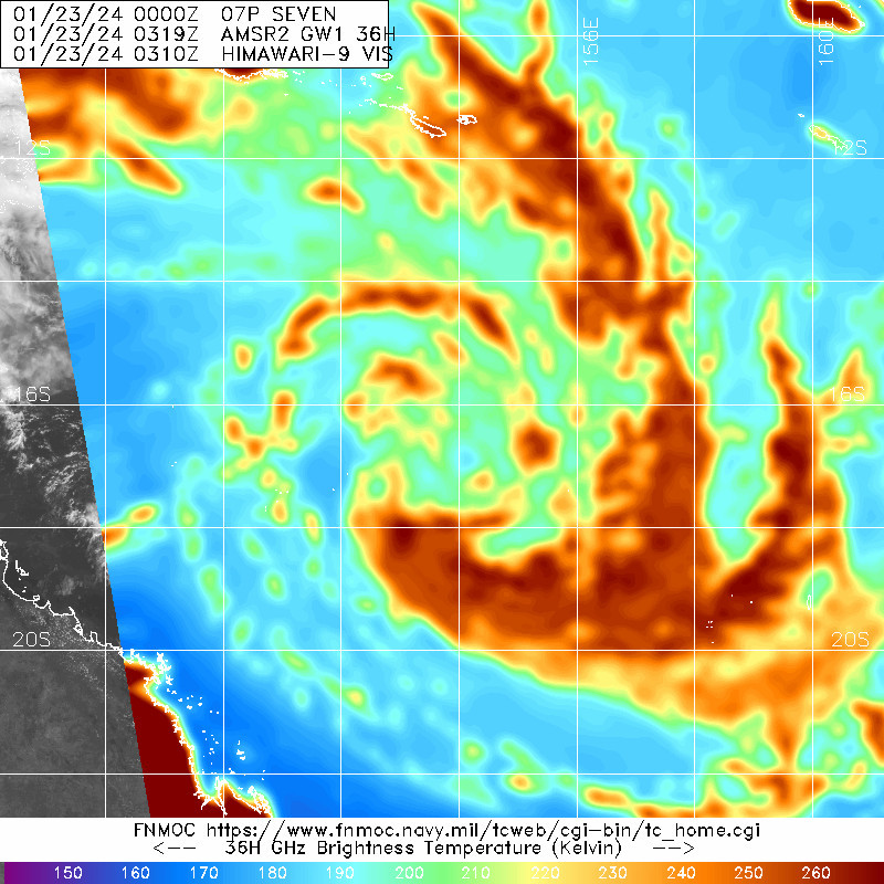
WDPS31 PGTW 230900
MSGID/GENADMIN/JOINT TYPHOON WRNCEN PEARL HARBOR HI//
SUBJ/PROGNOSTIC REASONING FOR TROPICAL CYCLONE 07P (SEVEN)
WARNING NR 002//
RMKS/
1. FOR METEOROLOGISTS.
2. 6 HOUR SUMMARY AND ANALYSIS.

SUMMARY:
   INITIAL POSITION: 17.1S 153.6E
   INITIAL INTENSITY: 35 KTS
   GEOGRAPHIC REFERENCE: 448 NM EAST OF CAIRNS, AUSTRALIA
   MOVEMENT PAST 6 HOURS: SOUTH-SOUTHWESTWARD AT 06 KTS
   SIGNIFICANT WAVE HEIGHT: 15 FEET

SATELLITE ANALYSIS, INITIAL POSITION AND INTENSITY DISCUSSION:
TROPICAL CYCLONE (TC) 07P HAS CONTINUED TO STRUGGLE TO ORGANIZE DUE
TO THE BROAD UPPER-LEVEL LOW POSITIONED OVER THE CENTER, EXTENDING
WESTWARD TO THE AUSTRALIAN GOLD COAST. CONSEQUENTLY, ANIMATED
MULTISPECTRAL SATELLITE IMAGERY (MSI) DEPICTS MULTIPLE MESOVORTICIES
ROTATING CYCLONICALLY AROUND A BROAD, EXPOSED CENTER, WITH DEEP
CONVECTIVE BANDING DISPLACED EASTWARD AND POLEWARD. A 230319Z AMSR2 36
GHZ MICROWAVE IMAGE REVEALS A FAIRLY RAGGED LOW-LEVEL CIRCULATION
CENTER (LLCC) WITH FRAGMENTED INNER SHALLOW BANDING WRAPPING AROUND
THE LLCC. A RECENT 222243Z ASCAT-B IMAGE REFLECTS THE BROAD NATURE OF
THE SYSTEM, SHOWING AN ELONGATED CENTER WITH GALE-FORCE WINDS
DISPLACED TO THE NORTHEAST AND SOUTHWEST. THIS ASCAT IMAGE WAS USED TO
TAILOR THE INITIAL WIND RADII VALUES. OVERALL, THE INITIAL POSITION IS
PLACED WITH MEDIUM CONFIDENCE BASED ON THE CENTROID POSITION EVIDENT
IN MSI AND THE AMSR2 IMAGE. THE INITIAL INTENSITY OF 35 KTS IS
ASSESSED WITH HIGH CONFIDENCE BASED ON SUBJECTIVE DVORAK ESTIMATES,
RECENT ASCAT DATA AND THE CIMSS OBJECTIVE ESTIMATES.

INITIAL WIND RADII BASIS: SCATTEROMETER DATA

CURRENT STEERING MECHANISM: COMPETING STEERING ENVIRONMENT WITH
SUBTROPICAL RIDGES POSITIONED TO THE EAST AND WEST.

AGENCY DVORAK AND AUTOMATED FIXES:
   PGTW: T2.5 - 35 KTS
   KNES: T2.0 - 30 KTS
   ABRF: T2.5 - 35 KTS
   CIMSS ADT: 35 KTS AT 230600Z
   CIMSS AIDT: 33 KTS AT 230600Z

FORECASTER ASSESSMENT OF CURRENT ENVIRONMENT: MARGINALLY FAVORABLE
   VWS: 5-10 KTS
   SST: 29-30 CELSIUS
   OUTFLOW: MODERATE POLEWARD AND EQUATORWARD

ANALYSIS CONFIDENCE:
   INITIAL POSITION: MEDIUM
   INITIAL INTENSITY: HIGH
   INITIAL WIND RADII: MEDIUM

3. FORECAST REASONING.

SIGNIFICANT FORECAST CHANGES: THERE ARE NO SIGNIFICANT CHANGES TO
THE FORECAST FROM THE PREVIOUS WARNING.

FORECAST DISCUSSION: TC 07P IS TRACKING SLOWLY WITHIN A COMPETING
STEERING ENVIRONMENT BUT IS FORECASTED TO TURN WEST-SOUTHWESTWARD
AFTER TAU 12 AS THE SUBTROPICAL RIDGE TO THE WEST, OVER EASTERN
AUSTRALIA, BUILDS TO THE SOUTH AND BECOMES THE DOMINANT STEERING
INFLUENCE THROUGH THE FORECAST PERIOD. OVER THE NEXT DAY, THE
UPPER-LEVEL LOW IS EXPECTED TO GRADUALLY ERODE, REPLACED BY
UPPER-LEVEL RIDGING. THIS WILL ALLOW THE SYSTEM TO INTENSIFY AT A
FASTER RATE TO A PEAK INTENSITY OF 60 KNOTS JUST PRIOR TO LANDFALL
NEAR TAU 48. AFTER TAU 48, THE SYSTEM WILL RAPIDLY WEAKEN AS IT
TRACKS INLAND, WITH DISSIPATION ANTICIPATED BY TAU 72.

MODEL DISCUSSION: DETERMINISTIC MODEL GUIDANCE REMAINS IN GOOD
AGREEMENT WITH A CROSS-TRACK SPREAD OF ONLY 60 NM AT TAU 48.
HOWEVER, SIGNIFICANT UNCERTAINTY IN THE INITIAL POSITION WILL
CONTINUE THROUGH TAU 24 THUS OVERALL CONFIDENCE IN THE JTWC TRACK
FORECAST IS MEDIUM. DUE TO THE COMPLEX, EVOLVING UPPER-LEVEL
ENVIRONMENT, THERE IS MEDIUM CONFIDENCE IN THE JTWC INTENSITY
FORECAST. RELIABLE INTENSITY GUIDANCE, INCLUDING THE HAFS-A AND
COAMPS-TC FORECASTS, INDICATES A PEAK INTENSITY RANGING FROM 45 TO
60 KNOTS. THE 221800Z COAMPS-TC ENSEMBLE INTENSITY PROBABILITIES
SHOW LOW PROBABILITY (20 TO 30 PERCENT) OF MODERATE INTENSIFICATION
OVER THE NEXT TWO DAYS.

FORECAST CONFIDENCE:
   TRACK 0 - 72 HR: MEDIUM
   INTENSITY 0 - 72 HR: MEDIUM//
NNNN
最后于 2024-01-23 18:00:00 被ygsj24编辑 ,原因: -
IDQ20018
TROPICAL CYCLONE TECHNICAL BULLETIN: AUSTRALIA - EASTERN REGION
Issued by AUSTRALIAN BUREAU OF METEOROLOGY TROPICAL CYCLONE WARNING CENTRE
at: 1254 UTC 23/01/2024
Name: Tropical Low
Identifier: 05U
Data At: 1200 UTC
Latitude: 17.1S
Longitude: 153.3E
Location Accuracy: within 30nm (55 km)
Movement Towards: south southwest (206 deg)
Speed of Movement: 4 knots (8 km/h)
Maximum 10-Minute Wind: 35 knots (65 km/h)
Maximum 3-Second Wind Gust: 50 knots (95 km/h)
Central Pressure: 994 hPa
Radius of 34-knot winds NE quadrant:
Radius of 34-knot winds SE quadrant: 130 nm (240 km)
Radius of 34-knot winds SW quadrant: 140 nm (260 km)
Radius of 34-knot winds NW quadrant:
Radius of 48-knot winds NE quadrant:
Radius of 48-knot winds SE quadrant:
Radius of 48-knot winds SW quadrant:
Radius of 48-knot winds NW quadrant:
Radius of 64-knot winds:  nm ( km)
Radius of Maximum Winds:   nm (  km)
Dvorak Intensity Code: T2.0/2.5/S0.0/24HRS STT:S0.0/06HRS
Pressure of outermost isobar: 1004 hPa
Radius of outermost closed isobar: 220 nm (405 km)
FORECAST DATA
Date/Time    : Location    : Loc. Accuracy: Max Wind   : Central Pressure
(UTC)        : degrees     :      nm  (km): knots(km/h): hPa
+06:  23/1800: 17.2S 152.9E:     045 (085):  035  (065):  994
+12:  24/0000: 17.3S 152.3E:     055 (100):  040  (075):  992
+18:  24/0600: 17.5S 151.8E:     060 (115):  040  (075):  991
+24:  24/1200: 17.7S 150.9E:     070 (130):  045  (085):  989
+36:  25/0000: 18.3S 149.0E:     075 (135):  050  (095):  984
+48:  25/1200: 19.3S 146.8E:     095 (175):  060  (110):  979
+60:  26/0000: 20.8S 144.9E:     115 (215):  030  (055): 1000
+72:  26/1200: 21.4S 144.1E:     140 (265):  030  (055):  998
+96:  27/1200: 22.3S 144.1E:     185 (340):  025  (045): 1000
+120: 28/1200: 23.2S 143.7E:     275 (510):  025  (045):  999
REMARKS:
Tropical Low 05U slow to develop.

Position based on afternoon VIS and microwave imagery with extrapolation to
1200z. There remains a fair amount of position uncertainty with an elongated
centre obscured by middle level cloud. Dvorak analysis: DT = 2.0 based on
curved band wrap of 0.3 averaged over 3 hours, the outer band has continued to
move away from the centre and an inner band has developed since 0500z; MET=2.0
with a S trend over the last 24 hours, PAT left at 2.0. FT=2.0 CI = 2.5.
Objective aids are becoming available: ADT 2.3 33 kn and 2.5 35 kn, AiDT 32 kt
(all 1-minute wind speeds). Intensity left at 35 kt with gales present in the
southern quadrants.

The system is currently interacting with an upper trough which is inhibiting
development. Convection is struggling to consolidate around the low level
centre. Otherwise, the general environment remains conducive for development.
SSTs remain high along the track at about 30 degrees Celsius. Moisture mostly
remains high over the system though water vapour shows some dry air on the
northwestern periphery, this area of dry air appears to be decreasing over
time. CIMSS upper level winds display good divergence over most of the system
with the exception of the NW quadrant where outflow appears to be impeded.
CIMSS vertical wind shear shows generally light to moderate shear over the
circulation. It is possible the interaction with the upper trough has slowed
the development more than was anticipated and the current forecast has delayed
formation time to 1200z/24th.

Over the next 12 hours movement is likely to be slow and then from about
Wednesday onward the upper trough will move east and a cradling mid-level ridge
should accelerate the system to the WSW, taking the system towards the
Queensland coast. The most recent NWP guidance has lowered the forecast
intensity despite the overall favourable environment. The forecast intensity by
landfall of 60kn (category 2) is supported by about standard development from
Wednesday into Thursday.

The forecast track is based on a consensus of global numerical weather
prediction models. There is good consistency between the guidance for a coastal
crossing between Cardwell and Airlie Beach Thursday evening. There remains some
uncertainty in the timing of the crossing from as early as Thursday midday to
about Friday morning. This is represented by a narrow and long 72 hour
confidence cone with the track possibly as far west as Winton by Friday
afternoon.

During Friday, the system is forecast to track well inland with heavy rain and
strong winds likely along its path. Over the weekend, the track takes the
system further south, with heavy rain and strong winds possible for southern
and central Queensland. In the longer term, the system is likely to remain a
tropical low over inland Queensland which may bring further heavy rain for
parts of Queensland.

Copyright Commonwealth of Australia
==
The next bulletin for this system will be issued by: 23/1930 UTC.
Time (AEST) Intensity Category Latitude
(decimal deg.)Longitude
(decimal deg.)Estimated Position
Accuracy (km)0hr 10 pm January 23 tropical low 17.1S 153.3E 55 +6hr 4 am January 24 tropical low 17.2S 152.9E 85 +12hr 10 am January 24 tropical low 17.3S 152.3E 100 +18hr 4 pm January 24 tropical low 17.5S 151.8E 115 +24hr 10 pm January 24 1 17.7S 150.9E 130 +36hr 10 am January 25 2 18.3S 149.0E 135 +48hr 10 pm January 25 2 19.3S 146.8E 175 +60hr 10 am January 26 tropical low 20.8S 144.9E 215 +72hr 10 pm January 26 tropical low 21.4S 144.1E 265